Showing posts with label Thermal Expansion. Show all posts

Sunday, February 26, 2012

Utopia Planitia Scallops, Polygons, and Boulders


This terrain is covered by pits and scallops (pits open on one side), perhaps due to collapse after sublimation of subsurface ice.

This full-resolution anaglyph sample shows that the surface is cut into many polygons about 10 meters wide, that form as ice expands and contracts with temperature changes. There are also many meter-scale boulders on the surface, which must be rocks rather than blocks of ice, or they would not be stable on the surface.

More than 10 meters thickness of ice must have sublimated from some areas. (Sublimation is the process of going from a solid directly to a gas). How did the ice get deposited? One idea is that it's from snowfall (in a different climate), but then it is difficult to explain the presence of the boulders. The other possibility is transport through the shallow subsurface in very thin films of water over many years.

This is a stereo pair with ESP_025277_2275.

Photo credit: NASA/JPL/University of Arizona

Note: This image is located in northwestern Utopia Planitia; the closest named feature is Nier Crater, which is some distance off to the southeast.

Saturday, December 18, 2010

Circular Feature in South Polar Residual Cap


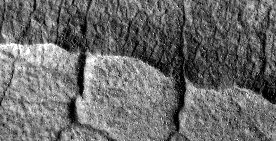
This 4 kilometer diameter feature near the edge of the south polar residual cap was recognized in Mariner 9 and Viking Orbiter images taken in the 1970s, but its origin could not be inferred. It was therefore targeted for HiRISE stereo imaging.

The bright areas in this image are covered by carbon dioxide frost, and the "swiss cheese" terrain typical of the south polar residual cap covers much of the imaged area. The dark walls of the circular depression do not have as much frost on them, and are fractured in a polygonal pattern. Apparently the surface of the walls has been extensively modified by thermal expansion and contraction of water ice.

It also appears that the "swiss cheese" terrain of the residual cap has buried the floor of the circular depression, as well as the terrain surrounding the feature, making it difficult to infer the origin of this depression. Its circular symmetry is consistent with an impact origin, but there is no evidence of a crater rim or ejecta (perhaps because they have been buried). The depression may have formed by collapse, but there is little evidence of extensional fractures that would be expected around a collapse pit. Analysis of HiRISE stereo data may help the interpretation of this feature.

Photo credit: NASA/JPL/University of Arizona

Monday, November 22, 2010

Scallop and Polygonal Features in Utopia Planitia


This observation, in Utopia Planitia, is marked by depressions in the mantle, several of which have coalesced together, and possess scalloped edges and layers.

Scalloped pits, such as these, are typical features of the mid-latitude mantle and are most commonly found at approximately 55 degrees North and South latitude; in Utopia Planitia, scalloped terrain is found between 45-50 degrees North latitude where the mantle is highly discontinuous. The presence of scalloped pits has led to hypotheses of the removal of subsurface material, possibly interstitial ice, by sublimation (evaporation). Scalloped depressions in Utopia Planitia have also been interpreted to be thermokarst lakes created by melting of a permafrost (frozen ground) and collapse of the dry surface layer.

Scalloped pits typically have a steep pole-facing scarp and a gentler equator-facing slope. This is most likely due to differences in solar heating.

On the surface surrounding the scalloped depressions are several large boulders (see subimage). Sources for these rocks may include ejecta from nearby craters, volcanic floods, or boulders emplaced by glaciers or periglacial processes. Also on the surrounding surface is a polygonal pattern of fractures. This is commonly associated with scalloped terrain, and indicates that the surface has undergone stress, potentially caused by subsidence, desiccation, or thermal contraction.

Variations in the sizes of the polygons seems to be partly dependent on their location with small polygons appearing within the scallops and larger polygons appearing outside the scallops on the surface of the mantle. Several cracks cut through the side of the scallops indicating that they must be at least as deep as the scallops. The polygons may have been present previous to the erosion of the mantle.

The formation of some scalloped depressions is believed to be an ongoing process today.

Photo credit: NASA/JPL/University of Arizona

Saturday, November 6, 2010

Curvilinear Ridge in Terra Meridiani


This image shows an arcuate ridge in Terra Meridiani. The ridge is most likely a former streambed, now exposed in inverted relief; the wandering path is not expected for an exhumed fault or volcanic dyke. The stream that formed this ridge must have been ancient as the ridge is buried by brighter rocks, which are themselves very old, having been thickly deposited and then heavily eroded.

The Mars Exploration Rover Opportunity landed in the same region of Mars, and the rocks it has examined are likely part of a sequence similar to that exposed here. The rocks exposed at the Opportunity landing site are mostly aeolian (wind-deposited) sandstone, but show evidence of past water reaching the surface at times. Opportunity has access to only a few meters of a stack of sediments that is hundreds of meters thick.

Since water was present at times at the Opportunity landing site, surface water elsewhere in the sequence of sediments is perhaps not too surprising. However, evidence like this may indicate that sediments were deposited by a broader range of processes than just those inferred at the Opportunity site. This is important for unraveling the entire history of the region.

A stream channel could become inverted in several ways. Chemicals precipitating from the water could bind the streambed together, lava could fill the channel, or the bed could contain large boulders. In each case, the relatively resistant material of the stream channel could remain as the surrounding rock eroded. Here, the ridge is distant from any volcanic vent, and appears fractured, particularly in the southern portion. This indicates that the ridge material is consolidated and has some strength. Thus, the most likely mechanism for formation of this ridge is deposition of a chemical "cement" which hardened the streambed rock.

The plains surrounding the ridge are also fractured, indicating some degree of consolidation. These cracks could form by desiccation (water loss) from wet sediment or tensile fracturing as the weight of overlying rocks was removed. Cracks like this can also form in permafrost due to seasonal temperature changes; ground ice is unlikely this close to the equator, but it is possible that the cracks are a remnant of different climate conditions from the past.

Photo credit: NASA/JPL/University of Arizona

Monday, October 25, 2010

Southern Hemisphere Crater with Dune Field


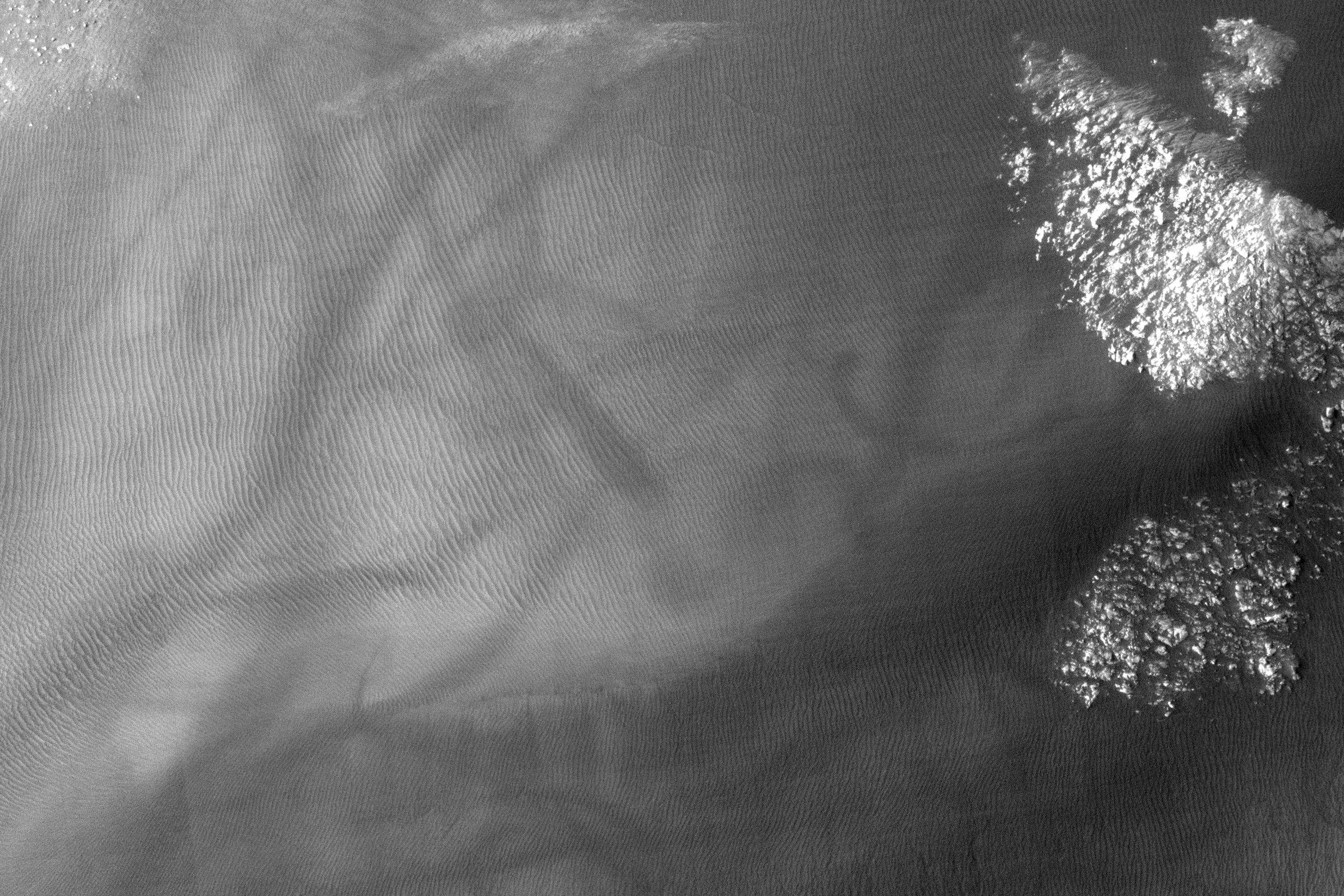
This observation shows a southern hemisphere crater with gullies, dunes, periglacial modification, bright rock deposits, and dust devil tracks. Although these features are all common on Mars, there are not many places that have all of them together as viewed here.

The gullies seen at the top of the image are likely caused by wet debris flows. They have deposits of multiple ages. The gully on the left has bright deposits that have been modified by periglacial processes overlain by slightly darker deposits that have not been modified. Periglacial processes, such as seasonal freezing and thawing, are responsible for the polygonal fractures seen near the gullies and around the image.

The dark material in the center of the image is a dune field. There are several different sizes and orientations of dunes — these different orientations indicate that the dominant winds in the area have changed throughout time.

The dark streaks that criss-cross on the outskirts of the dune field are dust devil tracks. Dust devils are spinning cells of dust that travel across the Martian surface. As they move, they pick up and redeposit particles, as well as disturbing dust on the surface. They are responsible elsewhere on Mars for removing dust from the solar panels of the Mars Exploration Rovers Spirit and Opportunity, which has helped to extend their missions way beyond the 90-day primary mission.

The subimage, 750 meters across, shows dust devil tracks near the southwest edge of the dune field. The bright protruding rocks to the right of the image are either being exposed or being buried as the dunes migrate.

Note that the black rectangular feature near the top right of the full image is a data gap resulting from data transmission problems; it is not a real feature.

Photo credit: NASA/JPL/University of Arizona

Note: This small crater is located east of Russell Crater in the Chalcoporos Rupes region.

Special Note:  This is Areology's 500th post!