Showing posts with label Plateaus. Show all posts

Sunday, December 7, 2014

Clays Along the Coprates Chasma Plateau


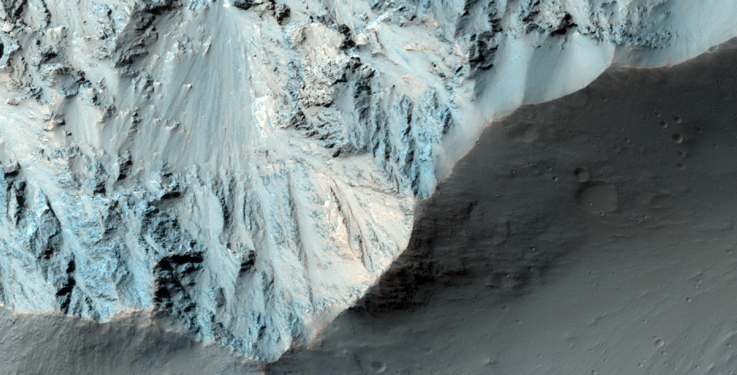
This image shows exposures of deposits along the plateau just to the south of Coprates Chasma.

Whereas Coprates Chasma and many of the other chasmata of Valles Marineris contain kilometer-thick light-toned mounds made up of sulfates, several of the deposits along the plateau have signatures of clays. This indicates that water was here for extensive periods of time to cause the plains to weather and alter into clays.

Image credit: NASA/JPL/University of Arizona

Note: For more information, see PIA18933: Clays along the Coprates Chasma Plateau.

Thursday, September 11, 2014

Aeolis Mensae


This VIS image shows a small portion of Aeolis Mensae, a complex region of hills, plateaus and graben. The prominent channel in the lower half of the image is a fault bounded graben.

Orbit Number: 56129 Latitude: -6.33435 Longitude: 146.63 Instrument: VIS Captured: 2014-08-09 10:00

Photo credit: NASA/JPL-Caltech/Arizona State University

Sunday, December 15, 2013

Juventae Chasma Topography


Color-coded topography map of Juventae Chasma. White and red show the highest terrains, while blue and purple show the deepest.

The floor of Juventae Chasma sits some 5.8 km below the surrounding plateau. It is filled with sand in the southern part (left), which takes on a smooth appearance, in contrast to the northern (right) part of this image where many blocky rock fragments have slumped down from the chasma walls. Two large mounds of layered material sit inside Juventae Chasma and comprise minerals altered by water.

This region was imaged by the high-resolution stereo camera on ESA’s Mars Express on 4 November 2013 (orbit 12,508), with a ground resolution of 16 ms per pixel. The image center is at about 4°S / 298°E.

Image credit: ESA/DLR/FU Berlin (G. Neukum)

Note: For more information, see Juventae Chasma 3D.

Saturday, November 2, 2013

Martian Thunderbird in Terra Sabaea


This non-circular pit is due to a low angle impact from an asteroid or comet. The raised plateau west of the crater was where most of the impact debris landed.

This debris protected the material underneath, but else where this material was slowly removed by the wind and the debris-covered area was left behind as this high-standing and interestingly-shaped plateau.

(Note: the wallpaper images have been rotated 90 degrees counterclockwise for better effect.)

Photo credit: NASA/JPL/University of Arizona

Note: This crater is located in Terra Sabaea slightly to the southeast of Schiaparelli Crater and northeast of Pollack Crater.

Note: For more information, see PIA17626: Martian Thunderbird.

Sunday, October 13, 2013

Hebes Chasma Mesa


The details of the central mesa inside Hebes Chasma are seen in close-up detail in this perspective view. A horseshoe-shaped chunk has been taken out of one side of the mound (left in this image); the material has slumped down onto the floor of the valley below. A dark patch appears to pool like spilt ink across the debris. It is most likely loose material that has slid down the walls from an intermediate layer. Melted ice could have played a role by weakening the rocks to create its flow-like appearance.

Along the side of the mound fine horizontal layering is seen. The layers likely comprise a mix of wind-blown dust and ancient lake sediments, along with remnants of the older plateau.

Photo credit: ESA/DLR/FU Berlin (G. Neukum)

Wednesday, May 2, 2012

How Did Valles Marineris Form?


This image (and its companion for stereo) crosses an impact crater about 50 kilometers (30 miles) wide. The crater was visible in Mariner 9 and Viking Orbiter images acquired decades ago, and was interpreted as evidence that the floor of Coprates Chasma was an old surface like that of the surrounding plateaus north and south of the canyon, and had dropped more than 10 kilometers (6 miles) as a huge intact block of crust.

However, this image and others acquired by MRO reveal a geologically young crater, with far fewer superimposed craters than the high plateaus, and well-preserved primary impact morphologies. This crater must have formed after the opening of Valles Marineris, and is not evidence, by itself, that this portion of the canyon system formed from simple downdrop of a giant intact block.

The opening of Valles Marineris did involve crustal spreading and faulting, but may have had a more complex history. Many of the large landslides in Valles Marineris could have been triggered by this impact event.

Photo credit: NASA/JPL/University of Arizona

Tuesday, November 23, 2010

Light Material in Ganges Chasma Wall


The troughs and chasms of the Valles Marineris system contain light toned deposits of enigmatic origin. The light materials, often layered, have variously been proposed to be volcanic ash or sediments laid down by rivers, lakes or sand dunes.

One aspect of the light toned material that has remained unclear is the timing of its deposition relative to canyon formation--was the material deposited in the troughs, or does it crop out in the walls, indicating that it existed before the Valles Marineris system formed?

This HiRISE image shows a part of the wall of Ganges Chasma. (This image, taken during the major dust storms which have raged through the summer of 2007, is grainy and low-contrast because of dust in the atmosphere.) The plateau above the chasm is at the bottom of the image, with the wall of the trough descending to the north. A few fine layers, likely basalt flows, form the cap layers.

In the spur at the center of the image, light material appears to crop out, contrasting with the relatively dark material elsewhere in the wall of the trough. At least some of this material is inherently lighter than other wall rock; changes in tone occur at several sites where there are no breaks in slope. The light material appears be forming spurs and ridges similar to the surrounding rock, suggesting that it comprises at least some part of the walls. However, darker, bouldery material occurs at the same level just to the west (left) of the light patch, indicating that the light outcrop may not extend very far.

Images like this provide clues to help unravel the history of deposition and deformation in Valles Marineris, and may eventually tell a complex story. In order to fully understand what this image means, several questions must be addressed: is this light material the same as intensively layered deposits observed elsewhere? How extensive are light wall materials? Are these materials conformable (part of a continuous sequence) with the rest of the wall? More HiRISE imaging will help address these questions.

Photo credit: NASA/JPL/University of Arizona

Wednesday, July 14, 2010

(Almost) Silent Rolling Stones in Kasei Valles


This observation shows the very steep side of a plateau, part of the northern limit of the Kasei Valles system, which is one of the largest outflow channel systems on Mars.

The difference in elevation here between the mostly flat channel's floor (bottom right) and the top of the plateau (top left) is over 1,300 meters (0.8 miles), comparable in height to the Grand Canyon walls.

The Kasei Valles system is much wider than the Grand Canyon, though, getting to be in places 500 kilometers (300 miles) wide. (The Grand Canyon's maximum width is 30 kilometers, or 18 miles).

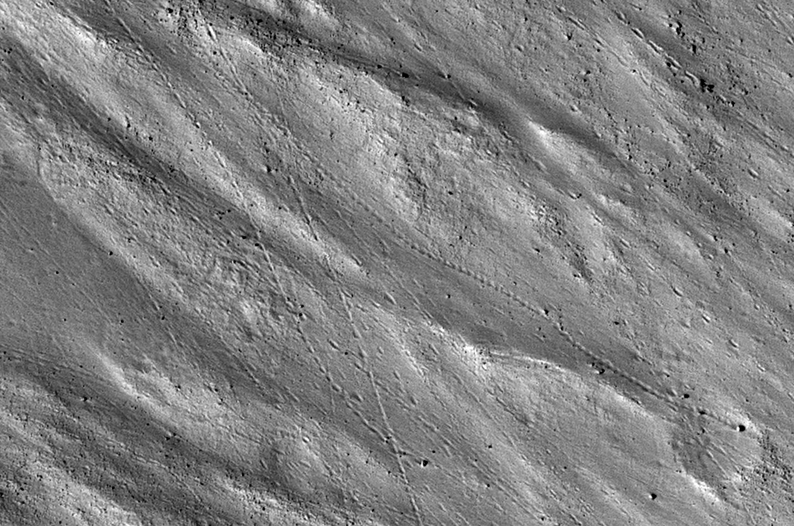
This subimage shows numerous paths with the appearance of dotted lines, criss-crossing the steep side of the plateau. The carving agents can be found at the end of some of these paths: rocky blocks such as the ones in this subset, up to 2 meters (2.2 yards) across (4 meters or 4.4 yards across elsewhere in the image).

Some of these blocks traveled downhill several hundred meters (yards) as they rolled and bounced leaving behind a trail of indentations or poke marks in the surface's fine-grained, light-toned soils. The raised borders in some of these poke marks indicate they are relatively recent features, unaffected by wind erosion, or that this soil has cohesive properties, such as if it was cemented [i.e., cohesive soil].

The sound of these blocks falling did not travel very far, though. According to computer simulations sound in Mars travels only 1.5 percent the distance it would travel on Earth. (No Martian sound has ever been recorded.) Hence, the same sound which would travel one kilometer (0.6 miles) on Earth would travel only 15 meters (16 yards) on Mars. This is due to the lower Martian atmospheric pressure, which is approximately one percent of that of Earth.

Photo credit: NASA/JPL/University of Arizona

Saturday, June 5, 2010

Exposed Light Material in Upland Region in Aureum Chaos


The plateau visible in this image is located within Aureum Chaos. Chaotic terrains on Mars are blocky, fractured regions of flat-topped hills, plateaus, plains, and depressions thought to have formed by the collapse of the heavily cratered uplands.

Large outflow channels appear to emerge from Aureum Chaos and other chaotic terrains leading researchers to posit that these large collapse regions were formed by the catastrophic release of ground water. Aureum Chaos is located just to the northeast of Valles Marineris adjacent to Margaritifer Terra, and it has a diameter of approximately 368 kilometers.

The steep-sided plateau in this image has a sharp, undulating surface possibly etched out and eroded by persistent winds. These same winds may well have transported the resulting sediment to the surrounding plains helping to form the dunes below. The plateau slopes are steep and consist of a series of parallel bright, more resistant cliff forming layers and darker, less resistant slope material. A good way to see the differences in color between the plateau's bright layered deposits and the surrounding area is to look at some of the blocks that have fallen off the cliff onto the the dark sands below.

By studying areas of Mars such as this one, researchers hope to understand how the chaos regions formed and how their formation related to the release of ground water to form the outflow channels, if indeed the two are connected in this way.

Photo credit: NASA/JPL/University of Arizona