Showing posts with label Plains. Show all posts

Thursday, September 18, 2014

Overlapping Lobate Lava Flows in Daedalia Planum


Lava flows south of Arsia Mons in Daedalia Planum transition from younger flows with elongated, sinuous morphologies to the northeast, to older, broader lobes and sheet flows to the southwest. (The time scale we’re talking about is approximately 100 million to 1 billion years.) At the southern margin of the Tharsis region, older, probably 3-billion year old volcanic plains have been identified where Tharsis flows contact the ancient highlands.

The high-resolution of HiRISE images allows for reconstruction of complex volcanic surfaces, including delineation of individual flow lobes and superposition relationships within a flow field. This image shows a contact between two of the younger, elongate flows to the northeast. Populations of small, superposed impact craters can be used to derive relative and absolute age constraints for individual flows and flow sequences.

Image credit: NASA/JPL/University of Arizona

Note: For more information, see PIA18807: Overlapping Lobate Lava Flows in Daedalia Planum.

Tuesday, July 29, 2014

Hills Near Phlegra Dorsa


The term "colles" means hills. The hills in this VIS image are located on the northern plains near Phlegra Dorsa.

Orbit Number: 54886 Latitude: 41.5743 Longitude: 155.977 Instrument: VIS Captured: 2014-04-29 03:37

Photo credit: NASA/JPL-Caltech/Arizona State University

Friday, July 25, 2014

Layering in Utopia Planitia


Today's VIS image shows layering in the plains that comprise Utopia Planitia.

Orbit Number: 54875 Latitude: 38.2154 Longitude: 112.575 Instrument: VIS Captured: 2014-04-28 05:54

Photo credit: NASA/JPL-Caltech/Arizona State University

Saturday, July 12, 2014

And More Dunes in Vastitas Borealis


Like yesterday's image, this VIS image shows more north polar dunes. If you compare multiple dune images, you will see that the dunes can take different forms and cover different amounts of the plains. The differences are caused by many factors including the amount of available sand, the force and direction of the winds, and the topography of the underlying plains.

Orbit Number: 54806 Latitude: 77.9098 Longitude: 109.282 Instrument: VIS Captured: 2014-04-22 13:16

Photo credit: NASA/JPL-Caltech/Arizona State University

Friday, June 27, 2014

Dust Devil Tracks in Acidalia Planitia


Today's VIS image of the northern plains show hundreds of dust devil tracks.

Orbit Number: 54706 Latitude: 62.5081 Longitude: 310.578 Instrument: VIS Captured: 2014-04-14 07:58

Photo credit: NASA/JPL-Caltech/Arizona State University

Note: This image is just off the northwestern edge of the ejecta blanket of the crater highlighted in this image.

Saturday, March 8, 2014

Ridges in Erythraea Fossa


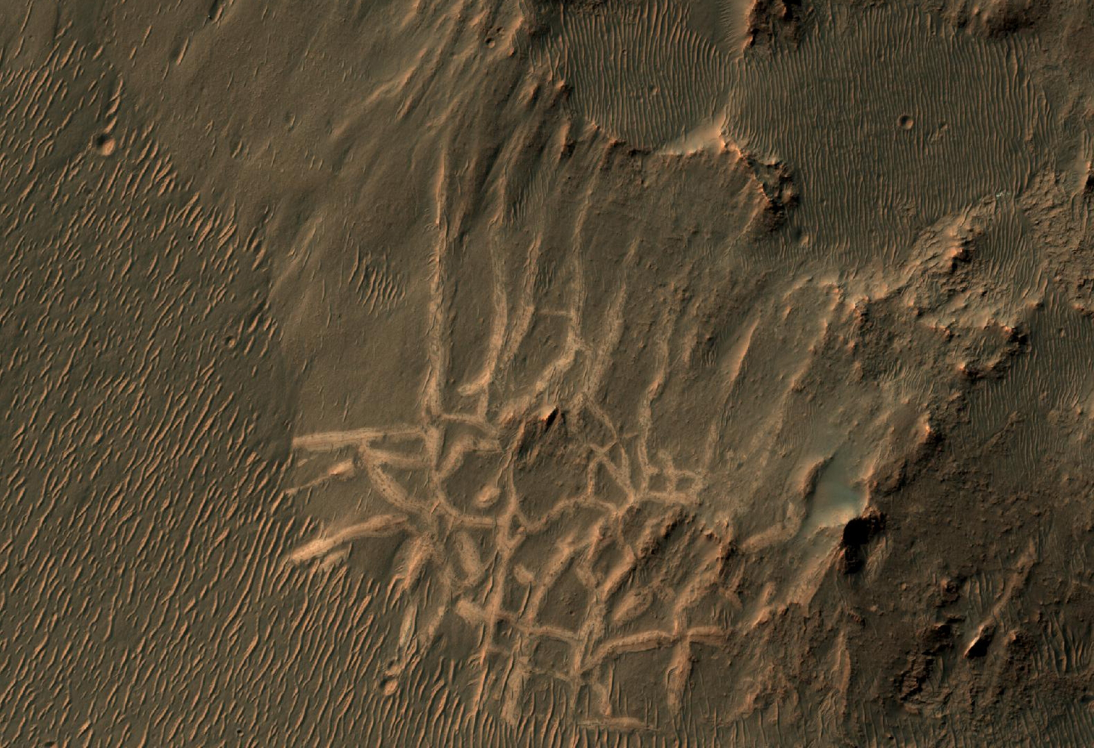
These light-toned ridges are found in a large fracture located east of Holden Crater and form a curious box-like pattern.

A hair-line fracture runs along the axis of each ridge line. The overall pattern spans several hundred meters across and individual ridges are several meters wide. Scientists are not sure how they formed yet, but some possible explanations suggest that mineral-rich ground water flowed out of the hairline fractures and deposited minerals at or near the surface as the water evaporated.

In addition, these minerals may have formed a cement along the fractures, making these patterns more resistant to subsequent erosion by wind or other processes. The resulting cemented ridges then stand high above the surrounding plains.

Photo credit: NASA/JPL/University of Arizona

Note: For more information, see PIA18112: Many Small Interesting Ridges in Erythraea Fossa.

Friday, February 14, 2014

(Yet More) Dust Devil Tracks in Utopia Planitia


Looking at yet another portion of Utopia Planitia, we still find hundreds of dust devil tracks.

Orbit Number: 53465 Latitude: 53.1584 Longitude: 86.4929 Instrument: VIS Captured: 2014-01-02 04:58

Photo credit: NASA/JPL-Caltech/Arizona State University

Thursday, February 13, 2014

(More) Dust Devil Tracks in Utopia Planitia


Today's VIS image shows a different part of Utopia Planitia than yesterday's image. Both are marked with hundreds of dust devil tracks.

Orbit Number: 53315 Latitude: 55.0129 Longitude: 91.1792 Instrument: VIS Captured: 2013-12-20 20:43

Photo credit: NASA/JPL-Caltech/Arizona State University

Wednesday, February 12, 2014

Dust Devil Tracks in Utopia Planitia


The dark markings in this VIS image are tracks made by the passage of "dust devils". Dust devils are common in the extensive plains of the northern latitudes. This image is located in Utopia Planitia.

Orbit Number: 53315 Latitude: 55.0129 Longitude: 91.1792 Instrument: VIS Captured: 2013-12-20 20:43

Photo credit: NASA/JPL-Caltech/Arizona State University

Saturday, February 1, 2014

Windstreaks Between Pavonis Mons and Noctis Fossae


The windstreaks in this VIS image are located on the lava plains between Pavonis Mons and Noctis Fossae. Streaks form on the down-wind side of positive topographic features (like hills and crater rims), indicating that the winds which created these streaks blew to the north east in this region.

Orbit Number: 53285 Latitude: -1.22511 Longitude: 255.604 Instrument: VIS Captured: 2013-12-18 07:48

Photo credit: NASA/JPL-Caltech/Arizona State University

South from Husband Hill


This section from a panorama that NASA's Mars Exploration Rover Spirit acquired in October 2005 from the top of "Husband Hill" presents the view toward the south from that summit. The entire 360-degree vista from Spirit's panoramic camera (Pancam) is available at http://photojournal.jpl.nasa.gov/catalog/pia03095.

After climbing Husband Hill, Spirit spent more than four years exploring locations within this view, including the "Comanche" outcrop and the "Home Plate" area. At Comanche, the rover found carbonate minerals, evidence of an ancient wet environment that was not acidic, and also a clue that some of the carbon dioxide in Mars' original atmosphere may have been converted to carbonates. Near Home Plate, Spirit found a deposit of nearly pure silica, evidence of an ancient environment of hot springs or steam vents.

The summit of Husband Hill is a broad plateau of rock outcrops and windblown drifts about 100 meters (300 feet) higher than the surrounding plains of Gusev Crater, where Spirit landed in January 2004.

This approximately true-color scene combines images taken through three different Pancam color filters, centered on wavelengths of 750 nanometers, 530 nanometers and 430 nanometers.

Image credit: NASA/JPL-Caltech/Cornell University

Saturday, March 16, 2013

Endeavour Crater's East Rim


Endeavour Crater is a large impact crater formed on Mars billions of years ago. Erosion and burial have filled in the depression and reduced the rim to a broken-up ring of hills made of rock that is older than the surrounding plains.

The Mars Exploration Rover (MER) Opportunity is currently exploring the west rim of the crater, and studying new types of rock that are very different from anything seen earlier in the mission. HiRISE images of the rest of the crater help the MER team plan their operations and understand how particular sites visited by the rover fit into the big picture.

Photo credit: NASA/JPL/University of Arizona

Saturday, August 11, 2012

Gale Crater by Curiosity


These are the first two full-resolution images of the Martian surface from the Navigation cameras on NASA's Curiosity rover, which are located on the rover's "head" or mast. The rim of Gale Crater can be seen in the distance beyond the pebbly ground.

The topography of the rim is very mountainous due to erosion. The ground seen in the middle shows low-relief scarps and plains. The foreground shows two distinct zones of excavation likely carved out by blasts from the rover's descent stage thrusters.

These are full-resolution images, 1024 by 1024 pixels in size.

Photo credit: NASA/JPL-Caltech

Note: For more information, see First 360-Degree Panorama From NASA's Curiosity Mars Rover. For the full 360-degree panorama (which is mostly made up of fuzzy thumbnail photos, see PIA16011: Curiosity Takes It All In.

Friday, April 27, 2012

Terrain Near the MSL Landing Site


This image is of a region slightly to the southwest of where the MSL rover, called Curiosity, will land in August 2012.

It shows three distinct terrains: (a) older plains, (b) an overlying unit with a distinct margin, and (c) recent sand dunes. The dunes indicate that the strongest winds tend to blow from the southwest toward the northeast and, like many dune fields on Mars, are probably moving slowly.

The second unit has a margin that, at low resolution, is similar to a lava flow. It also has a hard surface that retains impact craters better than the older plains beneath it.

At full HiRISE resolution it is evident that this deposit is not lava. It has thin layers and a dense network of fractures across its surface. The tops of some lava flows and lava lakes are also fractured. However, HiRISE has confirmed that the size and other characteristics of lava fractures are quite different from the ones visible here. Hence, this is some kind of sedimentary deposit, possibly consisting of largely of hardened mud.

It is likely that Curiosity will have an opportunity to investigate terrain like this soon after landing as it drives to the layered mound to the south.

Photo credit: NASA/JPL/University of Arizona

Monday, October 17, 2011

Sinuous Ridge in Malea Planum


This area of Malea Planum is covered by bright dust and dark lines. These lines formed by swirling winds known as dust devils that move across the surface removing the dust cover and revealing the darker rock materials beneath.

In the lower half of this image there is a faint sinuous, broad bouldery unit. Although largely dust covered, this sinuous unit may mark the location of a stream that once flowed across the plains. The stream may have later been filled by a lava flow or other bouldery material that was more resistant to erosion than the surrounding terrains forming what is known as an inverted stream. Since this time dust has largely filled in this terrain.

Photo credit: NASA/JPL/University of Arizona

Thursday, September 15, 2011

Fan and Dust Devil in Deuteronilus Mensa


This image shows what appears to be a degraded alluvial fan at upper left and a dust devil at lower right.

An alluvial fan is deposited by a river flowing out onto a plain; if this feature was formed by water, the activity ceased long ago, based on the density of craters on the fan surface.

The dust devil, on the other hand, is an example of the ongoing processes that continue to shape the surface of Mars.

Photo credit: NASA/JPL/University of Arizona

Note: This location is in Deuteronilus Mensae, to the southwest of Lyot Crater.

Update: The above caption has been translated into Spanish and republished by the HiRise team:

Abanico y Remolino de Polvo en Deuteronilus Mensa

Esta imagen muestra lo que parece ser un abanico aluvial degradado en la parte superior izquierda y un remolino de polvo en la parte inferior derecha.

Un abanico aluvial se deposita a través de un rio que fluye hacia una llanura. Si el agua formó este abanico, la actividad cesó hace mucho tiempo si nos fijamos en la densidad de cráteres sobre su superficie.

El remolino de polvo, por otra parte, es un ejemplo de los procesos que hay actualmente en funcionamiento y que dan forma a la superficie de Marte.

Monday, August 8, 2011

Dunes North of Aonia Planum


These dunes are located in a low plains region north of Aonia Planum.

Photo credit: NASA/JPL/Arizona State University

Note: The location of this photo is due West of Argyre Planitia, and to the Northeast of Douglass Crater.

Monday, January 17, 2011

Bright and Dark Plains near Ganges Chasma


This HiRISE image shows a mixture of bright and dark terrain along the plains just west of Ganges Chasma.

The concentration of these bright patches adjacent to an old impact crater suggests that the bright patches could represent ejecta from when the crater formed. This would be an interesting discovery because it would mean that a different unit underlies the surface we now see. Alternatively, much of the plains in this region appear to have a dark surficial cover, probably aeolian debris. Where this darker debris has been removed by the wind, the underlying brighter substrate would be exposed.

Mineralogic information from the CRISM instrument would be very useful for determining if the bright patches contain minerals indicative of water, such as clays, or if they are basalts produced from volcanic eruptions.

Photo credit: NASA/JPL/University of Arizona

Sunday, January 9, 2011

Ice-Rich Lobate Debris Aprons in Promethei Terra


This image shows a portion of a lobate debris apron along the bottom of a hill in the Promethei Terra region of Mars. This region contains many such mesas surrounded by lobate debris aprons that are thought to be ice-rich. These aprons have been interpreted as a variety of possible features including rock glaciers, ice-rich mass movements, or debris-covered glacial flows. Recent radar data have shown them to be composed of nearly 100% pure ice. Parallel grooves and ridges indicate the direction of flow.

Both the debris apron and the plains beyond it are blanketed with an ice-rich mantle that is common throughout the Martian mid-latitudes. The mantle deposits are pitted and grooved perhaps due to the sublimation of ice. This mantle is thought to have been deposited as snow around 10 million years ago during a period of high obliquity, when the planet's axis was more tilted and environmental conditions could have been more conducive to snowfall in these regions.

Several small impact craters are visible on the plains that appear to have been filled with mantling deposits that have subsequently been partially removed. These craters give us clues to the erosional history of the deposit.

Photo credit: NASA/JPL/University of Arizona

Note: This hill is located southwest of Pál Crater.