Showing posts with label Recurring Slope Lineae. Show all posts

Tuesday, May 27, 2014

Impact Crater Gully on the Southern Edge of Daedalia Planum


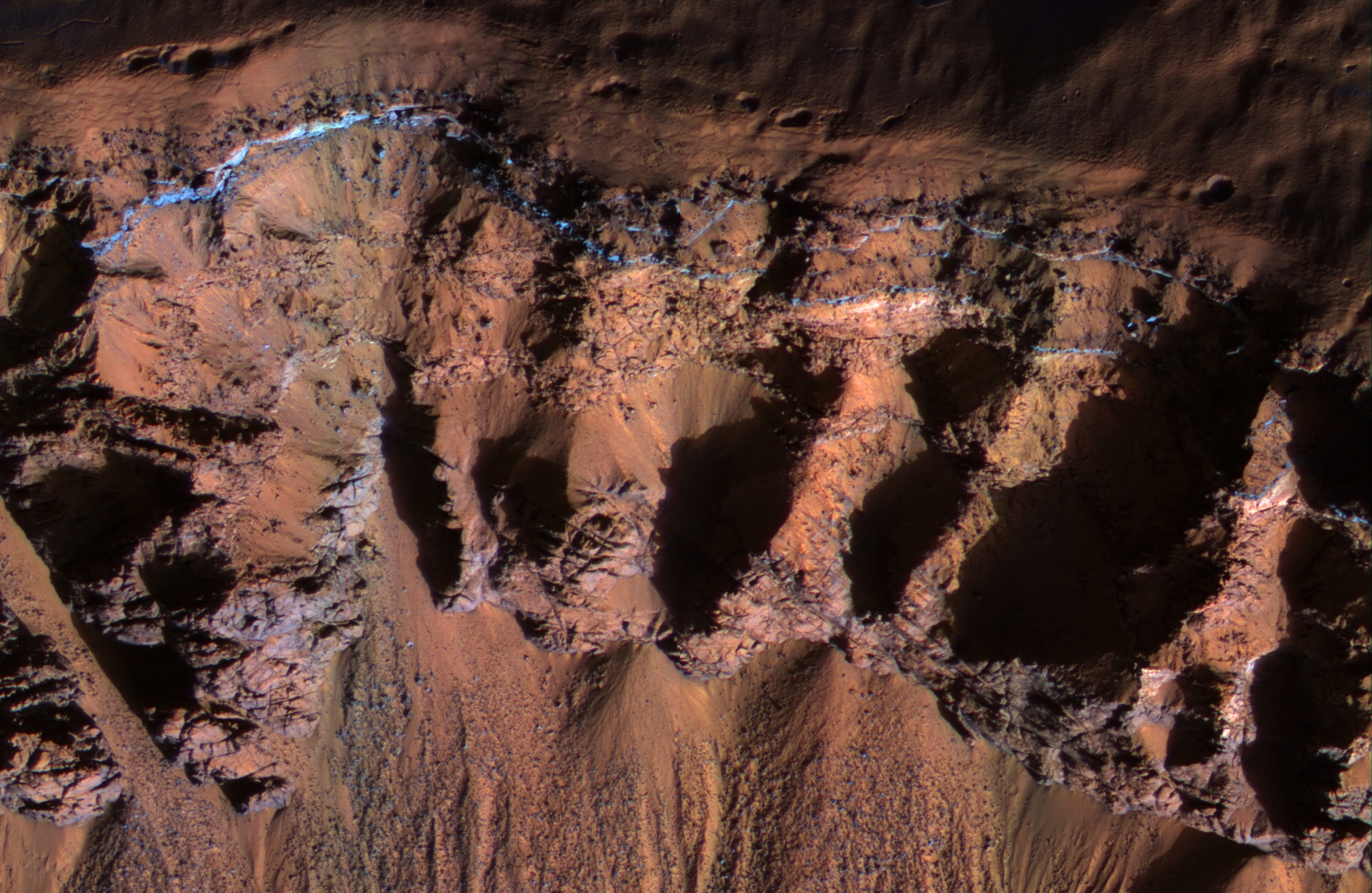
Right past the sharp, but warped rim of this ancient impact crater are deposits of winter frost, which show up as blue in enhanced color.

There are two possible science goals that we can study here: what does the terrain look like during the Martian summer, because HiRISE resolution can track changes over time. And second, could the gullies in this crater be a reasonable place to look for recurring slope lineae (or RSL) to occur? The slopes of certain craters have been home these phenomena in other regions as well.

Note: the images here are not map-projected, so approximate north is dow

Image credit: NASA/JPL/University of Arizona

Note: This impact crater is located to the east of Pickering Crater.

Monday, April 21, 2014

Slope Streak in Melas Chasma


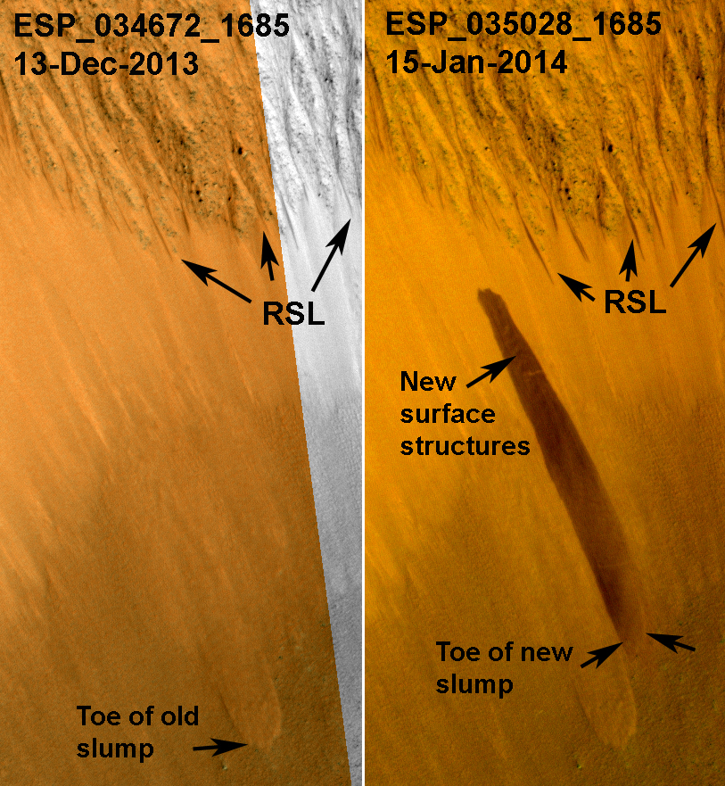
HiRISE has been monitoring the recurring slope lineae (RSL) over the mid-latitude and equatorial regions of Mars. One of these sites is a crater on the floor of Melas Chasma; and an animation shows how the RSL follow the sun, changing slope aspect with the seasons.

In one of our most recent images of this site, there was a surprise: a new dark streak just down slope from the RSL. This new streak is about 18 meters wide, whereas most RSL flows (see closer to the crater rim) are less than 5 meters wide. Closer inspection shows that the dark streak corresponds to a topographic slump, similar to several others visible on this slope.

This is one of the largest topographic changes we've seen in equatorial regions of Mars. We are continuing to monitor this location to see if this streak fades in the same manner as RSL, and to understand its relationship, if any, to the RSL activity. If the RSL are due to seeping water, then saturation of a layer downslope could destabilize the slope and lead to such slumps. We continue to be surprised by new discoveries from the Mars Reconnaissance Orbiter after 8 years in orbit.

Photo credit: NASA/JPL/University of Arizona

Note: For more information, see PIA18224: A Surprise Landslump in Melas Chasma.

Friday, March 28, 2014

Bedrock in a Trough in Asimov Crater


This image was acquired in southern winter over part of Asimov Crater (latitude 47.5 S), showing the equator-facing slope of a deep trough inside the crater. The crater appears to have been completely filled by a thick sequence of materials, perhaps including sediments and lava flows.

Later, deep troughs formed around the outer edge of the fill material<, probably by collapse over void spaces at depth. What made the void space is not known, but one idea is that there were lenses of ice that slowly sublimated into the atmosphere. Another idea is that this is part of a sequence of crater fill and "exhumation", that includes Gale Crater (home of the Curiosity rover). In other words, continued collapse and erosion of Asimov crater could eventually lead to a central mound like Eolis Mons (popular known as "Mt. Sharp") in Gale Crater. However, at Asimov crater, the southern trough has destroyed the southern rim of the original crater, which didn't happen at Gale Crater.

Many of these steep trough slopes in Asimov crater, where facing the equator, have recurring slope lineae (RSL) activity in the summer when the sun-facing slopes get warm. The RSL fade in the winter, so none are seen in this image even if they were present last summer. There are no previous HiRISE images acquired in the summer over this location.

Asimov Crater was named after Isaac Asimov, professor of biochemistry and prolific writer of science fiction and popular science books.


Photo credit: NASA/JPL/University of Arizona

Monday, February 24, 2014

Recurring Slope Lineae in Coprates Chasma


Recurring slope lineae (RSL) may be due to active seeps of water. These dark flows are abundant along the steep slopes of ancient bedrock in Coprates Chasma.

The enhanced-color cutout shows a full-resolution sample. The RSL are most prominent on the bright fans at the base of the bedrock, but actually extend back into the bedrock following small channels. MRO is continuing to monitor key sites to better understand this and other geologic activity on Mars.

This is a stereo pair with ESP_034619_1670.

Photo credit: NASA/JPL/University of Arizona

Wednesday, February 12, 2014

More Recurring Slope Lineae at Palikir Crater


Dark, seasonal flows emanate from bedrock exposures at Palikir Crater on Mars in this image from the High Resolution Imaging Science Experiment (HiRISE) camera on NASA's Mars Reconnaissance Orbiter. These flows, now documented at several places on Mars, form and grow during warm seasons when surface temperature is warm enough for salty ice to melt, and then fade or completely disappear in the colder season.

The location of this site is about 41.6 degrees south latitude, 202.3 degrees east longitude. The season was summer on southern Mars when this image was taken on June 27, 2011. Three arrows point to bright, smooth fans left behind by flows. The scale bar at lower right indicates 50 meters (164 feet). North is up.

These dark, warm-season flows are called "recurring slope lineae" or RSL. Researchers are using observations from Mars orbiters to study the possibility that RSL result from action of salty liquid water. Examples of RSL sites observed over a sequence of seasons are at PIA14472 and PIA14475.

This image, included in a paper by Lujendra Ojha of the Georgia Institute of Technology, Atlanta, and co-authors in Geophysical Research Letters, is one product from the HiRISE observation cataloged as ESP_023045_1380. Other products from the same observation are available at http://uahirise.org/ESP_023045_1380.

Image credit: NASA/JPL-Caltech/University of Arizona

Note: For more information, see NASA Mars Orbiters See Clues to Possible Water Flows.

Tuesday, February 11, 2014

Recurring Slope Lineae at Palikir Crater


This image combines a photograph of seasonal dark flows on a Martian slope with a grid of colors based on data collected by a mineral-mapping spectrometer observing the same area. The area is at Palikir Crater in the southern hemisphere of Mars.

The photograph is from the High Resolution Imaging Science Experiment (HiRISE) camera. The composition information, as an image with pixels appearing as a grid of squares, is from the Compact Reconnaissance Imaging Spectrometer for Mars (CRISM). Both of these instruments are on NASA's Mars Reconnaissance Orbiter. The view is oriented with north toward the bottom. The scale bar at lower left indicates 90 meters (295 feet).

These dark, warm-season flows are called "recurring slope lineae" or RSL. Researchers are using observations from Mars orbiters to study the possibility that RSL result from action of salty liquid water. This image was included in a paper by Lujendra Ojha of Georgia Institute of Technology, Atlanta, and co-authors in Geophysical Research Letters.

The purple and pink colors of the CRISM image represent spectra with absorption of light at wavelengths of 920 nanometers and 530 nanometers. The strength of these absorption bands at this site varies seasonally -- weaker when the RSL are inactive and stronger when the RSL are active. Absorption at 530 nanometers can indicate a concentration of ferric iron, so this could be a clue that the fluctuations observed in the absorption bands of iron minerals may be related to the RSL activity. Other image products from the same Nov. 2, 2007, HiRISE observation are available at http://www.uahirise.org/PSP_005943_1380.

Image credit: NASA/JPL-Caltech/UA/JHU-APL

Note: For more information, see NASA Mars Orbiters See Clues to Possible Water Flows.

Saturday, December 21, 2013

Recurring Slope Linea in Valles Marineris


These images from the High Resolution Imaging Science Experiment (HiRISE) camera on NASA's Mars Reconnaissance Orbiter show how the appearance of dark markings on Martian slope changes with the seasons. The marks, called recurrent slope linea, extend down slopes during warmer months and fade away during cooler months. This animation shows the same location at several times of year. The location is in a crater on the floor of Valles Marineris, near the Martian equator.

Photo credit: NASA/JPL-Caltech/University of Arizona

Note: For more information, see PIA17605: Long, Recurring Linear Marking on Martian Slope, PIA17606: Seasonal Changes in Dark Marks on an Equatorial Martian Slope, PIA17607: Maps of Recurrent Slope Linea Markings on Mars, and NASA Mars Spacecraft Reveals a More Dynamic Red Planet.

Monday, September 16, 2013

Slope Lineae along Coprates Chasma Ridge


The formation of "recurring slope lineae" is a fascinating process on Mars that we're just beginning to investigate, and one that we've imaged before in Palikir Crater.

These RSLs show up in the spring and fade in the winter. Their presence might be due to briny water, and it opens up the door to taking a fresh look at other possible RSL candidates. This observation was done to accomplish just that: to re-image a previously photographed area that might confirm if this a candidate for RSL.

When HiRISE re-images an area, we try to match the exact lighting as before, in order to see any differences. Along with a stereo pair and resulting anaglyph, our understanding of the terrain is more complete.

Photo credit: NASA/JPL/University of Arizona