Showing posts with label Rock Glaciers. Show all posts

Saturday, January 11, 2014

Banded Ridges in Hellas Planitia


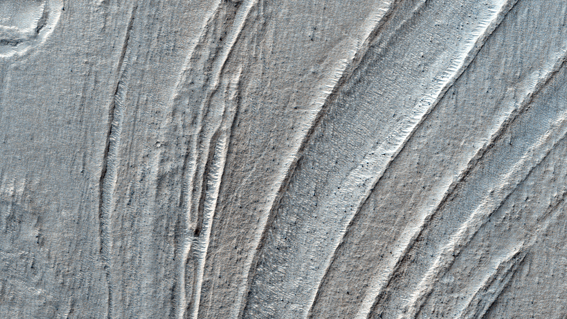
Low lying areas in the Hellas region -- which is the largest impact basin on Mars -- often show complex groups of banded ridges, furrows, and pits. These sorts of bands suggest that the surface material has flowed and twisted viscously like taffy. The orientation of the ridges and groups of ridges would then point in the direction of the flow, called stream lines.

Making this landscape even more complex is when we see that the ridges are sometimes disconnected. They stop abruptly, break up into blocky segments that sometimes appear offset. Such mixed up fragments give an initial sense that parts of the flow have been rafted apart from one another. Alternatively, the entire region may be substantially eroded since the time when the taffy-like ridges actually formed. In that case, the flow may have been far more complex and three dimensional, such that the disconnected portions are actually areas where the flow transitioned up and down relative to the current plane of the eroded surface. In this way we only see a slice through a far more complex series of twists and bends, some of which is still buried beneath the ground.

What this taffy-like material is made of is currently unknown. Hard and soft rocks, as well as ice and ice-rich rocky debris, can deform and flow given time under the force of gravity and the pressures found deep beneath the surface. Afterwards, differential erosion of hard and soft rock or icy materials mixed in bands and layers might give rise to the ridges, furrows and pits which we observe today.

Photo credit: NASA/JPL-Caltech/University of Arizona

Wednesday, July 18, 2012

Flows in Hellas Planitia


Hellas Planitia is the interior of the Hellas impact basin, is one of the largest visible impact craters in the Solar System. Hellas is located in the Southern highlands and formed very early in the planet's history. The floor of Hellas includes the lowest elevations on Mars and some of the strangest landscapes.

The most striking feature of this observation are the incredible banded features, probably due to the flow of surface material. Although Martian flow features may have Earth analogs such as rock glaciers, it's uncertain as to what types of fluvial, glacial and mass-wasting processes are involved in their formation.

This is a stereo pair with ESP_017644_1420.

Photo credit: NASA/JPL/University of Arizona
Monday, May 28, 2012

In the Transition Zone in Deuteronilus Mensae


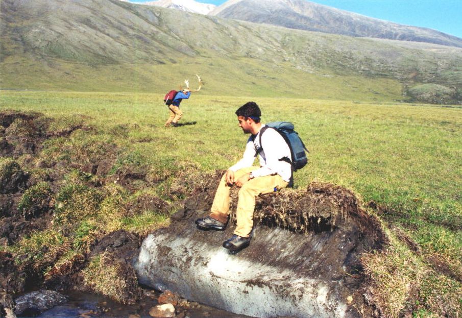
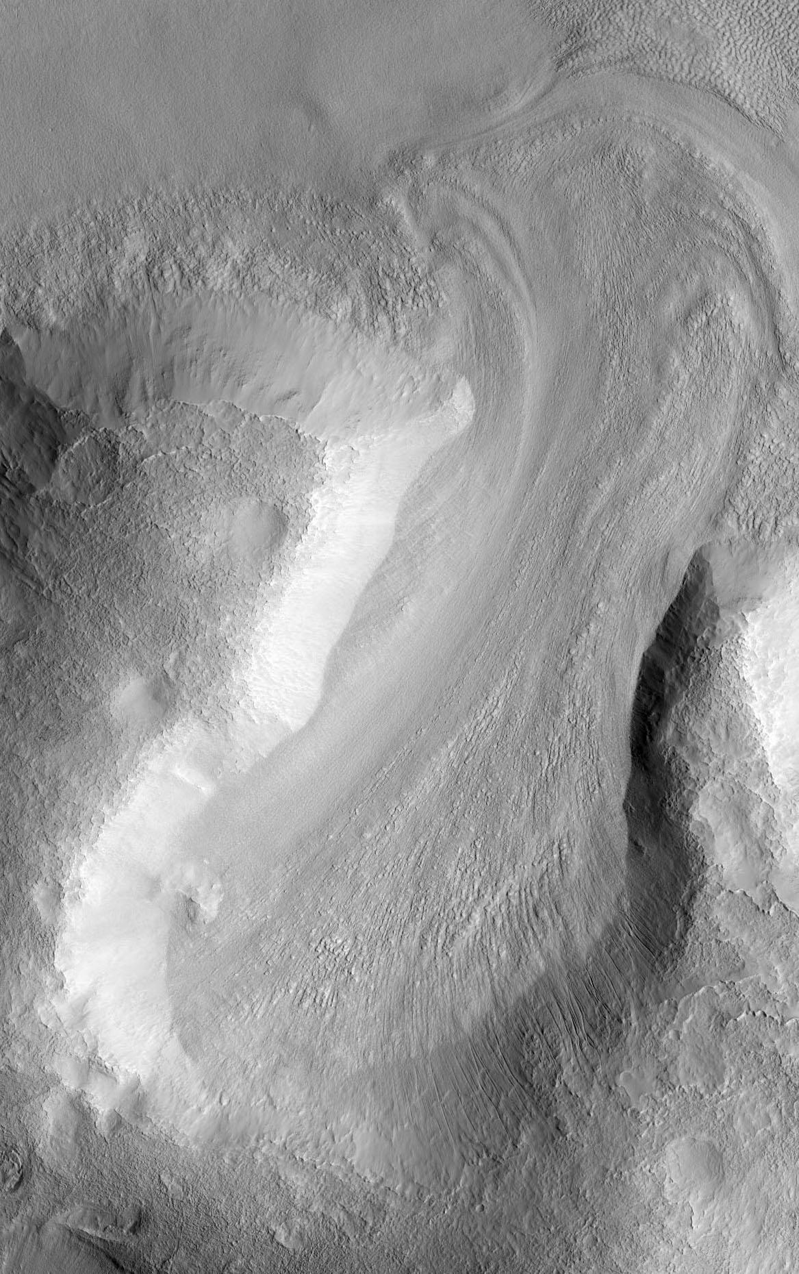
Nestled between mesas, this image shows the valley floor where eroded rocky and/or soil debris appears to have flowed viscously from the mesa walls across the valley to merge. A leading theory is that ice and snow became entrained with the soil debris as it shed from the mesa. This combined ice-rich debris then flowed slowly downhill. "Rock glaciers" on Earth are an analogous landform that flow viscously like a glacier, lubricated by ice trapped in the pore spaces.

The image shows light-toned viscous debris that overlays a darker toned surface. Both surfaces sport irregular fracture patterns and evidence that substantial erosion has since taken place. The upper viscous-flow surface also contains abundance small, regular polygonal patterns. Such patterns are commonplace in permafrost on Earth, and are typically considered strong evidence for shallow subsurface ice.

Erosion and the formation of small scarps reveal a multitude of layers within the subsurface. Such structure is unusual for a single glacial flow and may indicate episodic glacial advance and retreat. Additionally, the sparse population of rocks on the surface and along the eroded scarps suggest that the debris eroding from the mesas consists largely of soil.

Photo credit: NASA/JPL/University of Arizona
Note: This image is located in Deuteronilus Mensae, about half-way between Lyot Crater to the north and Sinton Crater to the south, in Arabia Terra.

Sunday, January 9, 2011

Ice-Rich Lobate Debris Aprons in Promethei Terra


This image shows a portion of a lobate debris apron along the bottom of a hill in the Promethei Terra region of Mars. This region contains many such mesas surrounded by lobate debris aprons that are thought to be ice-rich. These aprons have been interpreted as a variety of possible features including rock glaciers, ice-rich mass movements, or debris-covered glacial flows. Recent radar data have shown them to be composed of nearly 100% pure ice. Parallel grooves and ridges indicate the direction of flow.

Both the debris apron and the plains beyond it are blanketed with an ice-rich mantle that is common throughout the Martian mid-latitudes. The mantle deposits are pitted and grooved perhaps due to the sublimation of ice. This mantle is thought to have been deposited as snow around 10 million years ago during a period of high obliquity, when the planet's axis was more tilted and environmental conditions could have been more conducive to snowfall in these regions.

Several small impact craters are visible on the plains that appear to have been filled with mantling deposits that have subsequently been partially removed. These craters give us clues to the erosional history of the deposit.

Photo credit: NASA/JPL/University of Arizona

Note: This hill is located southwest of Pál Crater.

Friday, November 26, 2010

Glacier in Protonilus Mensae


Ice can be a powerful force of erosion, particularly when it accumulates into thick deposits. Glaciers on Mars were once proposed to be likely because of the planet's cold temperatures. The global average temperature of Mars is about -68 Celsius (-90 Fahrenheit).

Glacial-looking landforms are now seen to be commonplace, and even abundant in mountainous regions at higher latitudes such as here in Protonilus Mensae. These landforms are quite similar in appearance to glaciers on Earth.

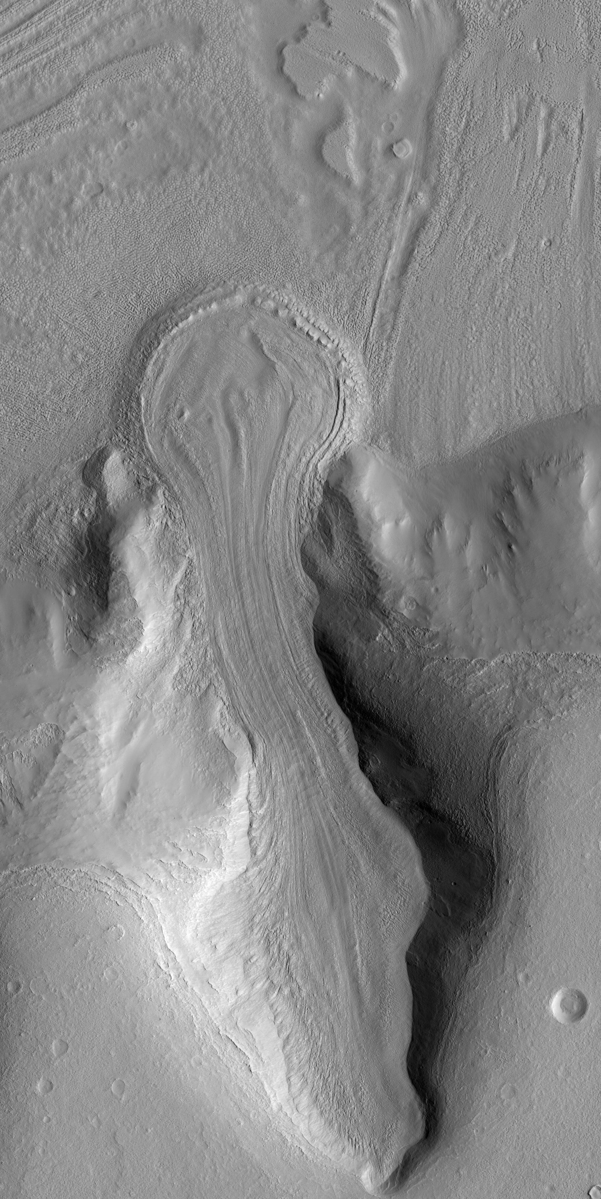
This image shows an example of such a landform. The mountain valley to the north (toward the bottom of the unprojected image) would be the zone of accumulation of snow and ice, which then flowed downhill (toward the top of the image) and out onto a neighboring plain. The evidence of this flow comes from the myriad of stream lines and flow fronts visible in the surface topography. Some of these topographic features may also be "moraines," ridges of rock and soil debris common on the surface of glaciers and at the boundaries.

Boulders up to 3 meters (9 feet) in size are visible on the surface of this feature. If you trace the streamlines from these boulders back uphill into the accumulation zone then you'll see where boulders have tumbled off the valley walls before being rafted downhill to their current location. This process continues today even though the feature itself may not be flowing significantly anymore.

Once onto the more level plain, the ice flow stalled and spread out into a bulb shaped pile where it would have gradually evaporated, called the ablation zone." Melting of the ice might have also occurred, though geologic evidence of melting has not yet been found.

Today, Mars is very dry place, and surface ice is unstable everywhere except on the polar caps. Any ice left on the surface would evaporate without ever melting, a process called "sublimation." However, past climate changes may have periodically allowed snow and ice to be stable on the Martian surface and even to build into glacial masses, hundreds of meters (yards) or more in thickness.

In this image, the surface is made up of regolith (rock and soil debris) and no ice is visible. Interestingly, subsurface ice may still be present as relatively soil-free ice, which would then be called a "debris covered glacier." Ice may also occur as a cement between rocky material throughout the glacial deposit and would also be capable of flowing like a glacier, which is called a "rock glacier." Alternatively, the ice may have all sublimated and what we see now is a residue of the "glacier till," remnant ice-free rock and soil debris.

Future stereo images of this landform will help scientists to understand the surface tilt and the forces driving ice flow under Martian gravity. In addition, stereo topography may help in estimating the thickness of the feature we see here and if any subsurface ice may still be present.

Photo credit: NASA/JPL/University of Arizona
Tuesday, November 9, 2010

Channel and Fan in Lyot Crater


Extensive flow of liquid water across the surface of Mars is generally constrained to the first billion years of the planet's evolution. There are some specific places, however, where liquid water may have been stable later in the planet's history, when Mars is considered to have been cold and dry. Lyot Crater is one of those places.

Lyot Crater is a "peak-ring basin" that formed in the lowlands of the northern hemisphere of Mars, making it the lowest topographic point in the northern hemisphere. Additionally, we know that the Lyot impact event occurred after the most significant era of fluvial activity on Mars, so any features observed in Lyot were formed after that era as well.

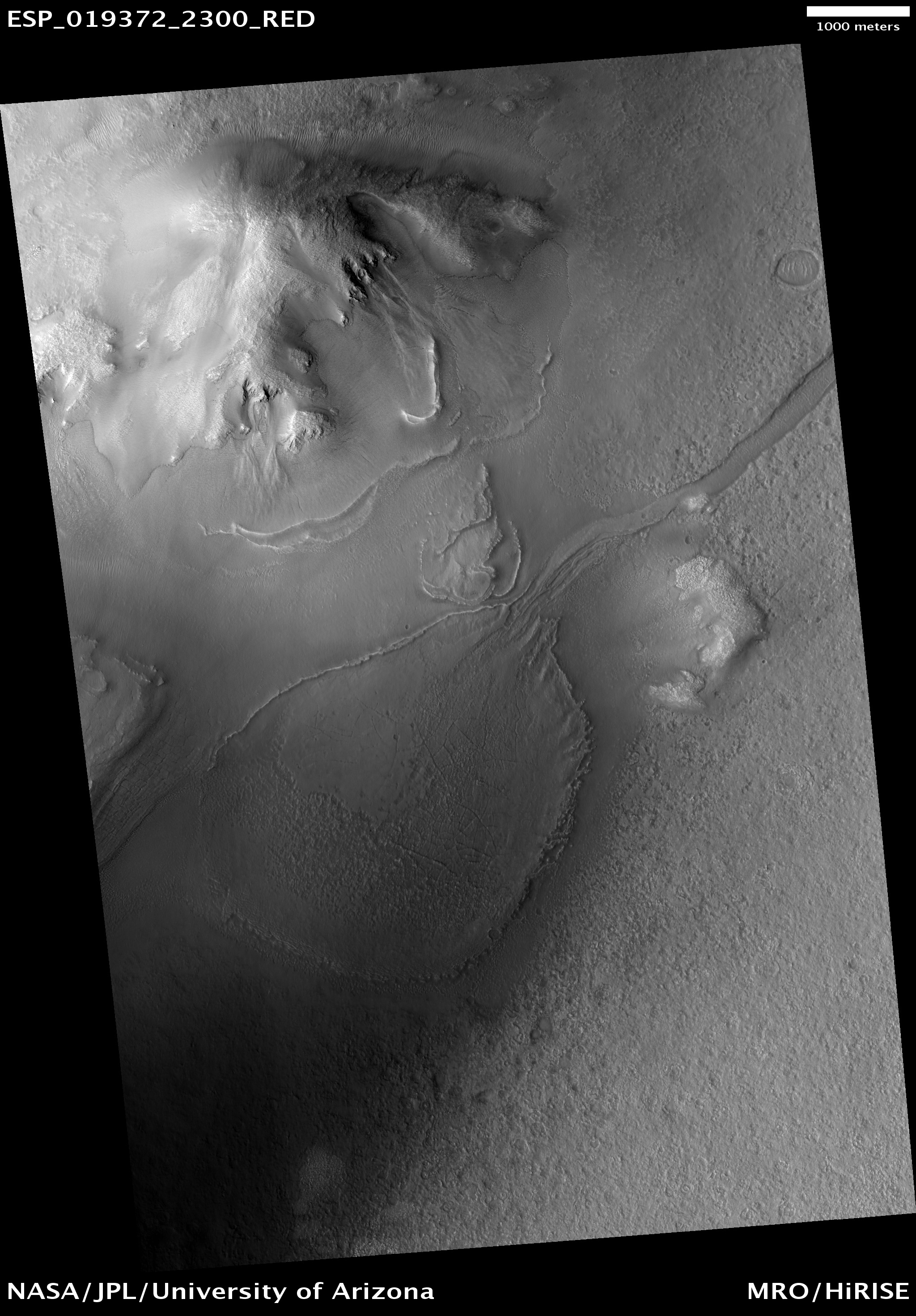
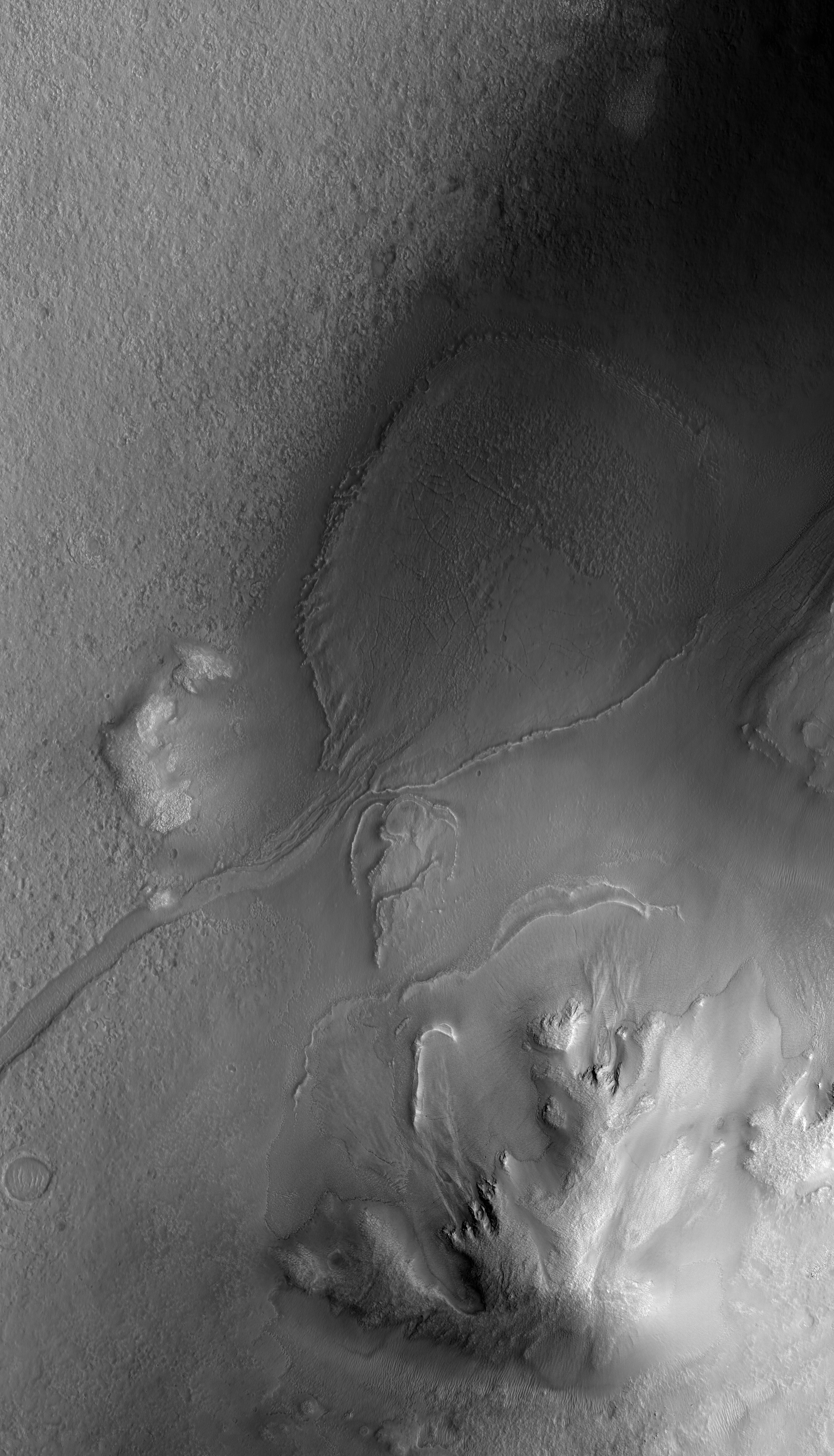
This observation shows what appears to be a very unusual fan of material that is sourced by a valley that extends upslope for almost 50 kilometers along the floor of Lyot Crater (top-right of the full image [see also here]). The fan is not fresh, so this activity pre-dates the Martian gullies (a few of which can be seen at the top of this image). The fan has been mantled by smooth material which has been removed in some areas and fractured in others. This makes it difficult to tell what the fan looked like when it was originally emplaced.

Lyot Crater is found in a region of Mars that is thought to host many debris-covered glaciers (some of which are found within Lyot itself) and ice-rich mantling units. These could provide potential sources of water that, under conditions slightly more favorable than those of today, could melt and create features like we see here.

Photo credit: NASA/JPL/University of Arizona

Tuesday, August 31, 2010

Concentric Crater Fill in the Northern Plains


This observation shows part of an unnamed crater located in the Northern plains.

The intriguing landforms in the floor of this crater are known as "concentric crater fill." Such landforms are found at high latitudes (approximately above 30 degrees from the equator), where theoretical calculations indicate that ice may exist under the surface, mixed with rocks and soil. Examples of concentric crater fill were first observed in the 1970s, in images acquired by cameras on board the Viking orbiters.

The roughly concentric ridges and troughs in the crater's floor are believed to result from compression caused by viscous flow of a thick mixture of rocks, soils, and ice inward from the crater's walls.

Impact craters with concentric fill are usually shallower than other craters. The crater in this image is approximately 12 kilometers (7.5 miles) in diameter, and 200-400 meters (220-440 yards) deep; other Martian craters of similar diameter but without concentric fill may be as deep as 700 meters (765 yards). Unlike in "regular" craters, the slopes of the walls of craters with concentric fill tend to be convex, and the crater's rim is more rounded.

All these characteristics are consistent with deformation of an ice-rock mixture similar to what's observed in rock glaciers on Earth.

Photo credit: NASA/JPL/University of Arizona

Note: This crater is located in Colles Nili region, which lies between Arabia Terra and Utopia Planitia. The closest named crater is Renaudot, which is to the north of this site.

Friday, May 14, 2010

Viscous Flow in Protonilus Mensae


This subimage highlights a feature that resembles a terrestrial glacier, indicating that material has viscously flowed at this location. It appears that water ice has collected at the head of the valley (at bottom), allowing glacier-like flow toward the top of the subimage.

At the top right of the subimage, the flow appears to have slowed down and stopped, forming ridges perpendicular to the flow direction. Similar features are observed on terrestrial glaciers, but Martian examples are not as bright as many on Earth. The Martian glaciers appear to be covered by dust and other debris, hiding the ice below. Such debris-rich flows on Earth are called "rock glaciers" and may be good analogs for the flow seen here.

Photo credit: NASA/JPL/University of Arizona

Note: This photo was taken in the Protonilus Mensae region, which is located between the northeastern-most tip of Arabia Terra and Vastitas Borealis. The location of this glacier is roughly halfway between the craters of Moreux and Renaudot, being slightly closer to Renaudot.

Saturday, May 8, 2010

Knobs near Reull Vallis


This observation shows a knob and large crater near Reull Vallis, east of the Hellas Basin. The crater's ejecta blanket abuts the base of the knob. The crater floor and ejecta are blanketed with an ice-rich mantle that is common throughout the Martian mid-latitudes.

The mantle deposits are pitted and grooved perhaps due to the sublimation of ice. This mantle is thought to have been deposited as snow around 10 million years ago during a period of high obliquity, when the planet's axis was more tilted and environmental conditions could have been more conducive to snowfall in these regions.

Several small impact craters are visible on the ejecta blanket that appear to have been filled with mantling deposits that have since been partially removed. These craters give us clues to the erosional history of the deposit. Note the fresh looking impact crater at the top of the knob. This crater does not appear to contain mantling deposits and may be much younger.

This region contains many mesas surrounded by lobate debris aprons that are thought to be ice-rich. These aprons have been interpreted as a variety of possible features including rock glaciers, ice-rich mass movements, or debris-covered glacial flows. Reull Vallis itself is filled with what is referred to as "fretted terrain," which is also thought to be ice-rich material.

Photo credit: NASA/JPL/University of Arizona

Friday, April 2, 2010

Lobate Debris Apron in Deuteronilus Mensae

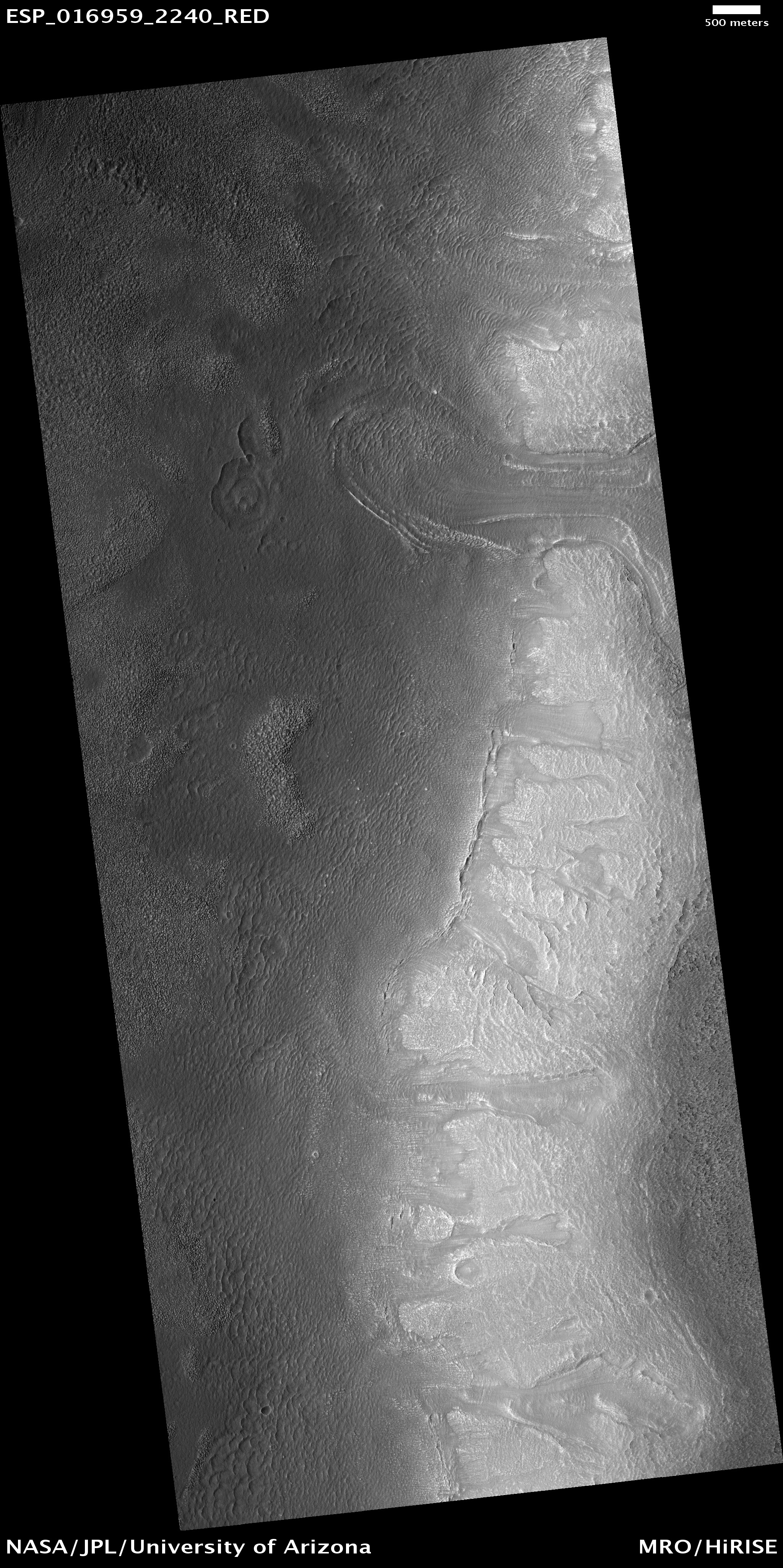
 (ESP_016959_2240)

This observation is located in the Deuteronilus Mensae region along the highland/lowland dichotomy boundary in the Northern hemisphere of Mars.

This region contains many mesas surrounded by lobate debris aprons that are thought to be ice-rich. These aprons have been interpreted as a variety of possible features including rock glaciers, ice-rich mass movements, or debris-covered glacial flows. Recent radar data from the MRO SHARAD instrument has shown them to be composed of nearly pure ice.

The full image shows the edge of one of these mesas with a lobate debris apron extending from its base. Both the mesa top and the surface of the debris apron appear covered with ice-rich mantling materials characteristic of the Martian mid-latitudes and thought to have been deposited around 10 million years ago during a period of high obliquity. Ice-rich flows also extend down the side of the mesa onto the surface of the apron, as evidenced by the lobate flow near the top of the image. Several alcoves can also be seen along the mesa wall that appear to be filled with "pasted-on" mantling deposits. Similar features have been observed along the walls of Dao Vallis east of the Hellas Basin, a mid-latitude region that also contains lobate debris aprons.

Photo credit: NASA/JPL/University of Arizona

Note: Deuteronilus Mensae is an "archipelago" of flat-topped knobby terrain located between Lyot Crater to the north and Arabia Terra to the south.

Friday, March 19, 2010

Tongue-Shaped Flow Feature in Hellas Planitia


This image captures a tongue-shaped lobate flow feature along a interior crater wall located in eastern Hellas Planitia.

The flow feature is approximately 5 kilometers long and 1 kilometer wide with a partial double inner ridge and raised outer margin. The flow feature's surface is generally devoid of impact craters and parts of its outer margin have deflected around obstacles.

Similar flow features, though not as distinctively tongue-shaped as this one, are found in many other craters throughout the southern mid-latitudes of Mars.

Recent studies of these flow features have determined a latitudinal dependence to which side of the crater interior these features are formed upon. For this particular flow feature, it has formed on the pole-facing slope. This polar or equatorial-facing preference has implications for the amount of solar insolation these slopes are receiving, which may be a result of recent climate change due to shifts from low to high obliquity.

Although these Martian flow features may have Earth analogs such as rock glaciers, uncertainty remains as to what types of fluvial, glacial and mass-wasting processes are involved in their formation. This particular flow feature was imaged previously by the Mars Orbiter Camera (MOC) onboard NASA's Mars Global Surveyor spacecraft.

Photo credit: NASA/JPL/University of Arizona