Thursday, February 28, 2013

Faults in Sinai Dorsa


The depressions and offset ridge in today's VIS image are evidence of faulting in this region of Sinai Dorsa.

Orbit Number: 49313 Latitude: -13.3538 Longitude: 281.678 Instrument: VIS Captured: 2013-01-25 11:27

Photo credit: NASA/JPL-Caltech/Arizona State University

Wednesday, February 27, 2013

Dunes in Hussey Crater


This VIS image shows part of the dune field on the floor of Hussey Crater.

Orbit Number: 49277 Latitude: -52.8798 Longitude: 233.008 Instrument: VIS Captured: 2013-01-22 12:33

Photo credit: NASA/JPL-Caltech/Arizona State University

Tuesday, February 26, 2013

Arsia Mons


This VIS image shows the eastern flank of Arsia Mons midway between the summit of the volcano and the surrounding plains. Note the small linear fractures which trend towards the top of the image; these fractures encircle the volcano.

Orbit Number: 49227 Latitude: -9.4723 Longitude: 241.774 Instrument: VIS Captured: 2013-01-18 09:34

Photo credit: NASA/JPL-Caltech/Arizona State University

Yellowknife Bay, Annotated


From a position in the shallow "Yellowknife Bay" depression, NASA's Mars rover Curiosity used its right Mast Camera (Mastcam) to take the telephoto images combined into this panorama of geological diversity.

A lip defining the edge of Yellowknife Bay is visible in the middle distance near the center of the image and in the farther distance on the right.

Shown in this panorama are the locations of the "Selwyn" section, the "John Klein" drill area, and the approximate distance between them. The Curiosity science team completed an extensive investigation of the chemical and textural properties of the rocks at these locations in advance of drilling at John Klein. This investigation included 25 analyses from the Alpha Particle X-ray Spectrometer (APXS), more than 1,000 images from the Mars Hand Lens Imager (MAHLI), and more than 12,000 laser shots from the Chemistry and Camera instrument (ChemCam).

The scene is a combination of three mosaics taken on Sols (Martian days) 137, 138, and 141 of Curiosity's work on Mars (December 24, 25 and 28, 2012). Each sol's images were acquired between about 8:30 and 9:30 a.m., local Mars solar time. Distances from the rover range from about 10 feet (3 meters) for the closest objects in the picture to about 100 feet (30 meters) for the most distant ones.

The mosaics have been white-balanced to show what the rocks would look like if they were on Earth. This image was originally released without labels on January 15, 2013, and can be found at PIA16701.

Image credit: NASA/JPL-Caltech/MSSS

Note: For more information, see PIA16687: Zapped, Martian Rock, PIA16688: Sifting Martian Samples, PIA16729: First Curiosity Drilling Sample in the Scoop and PIA16730: Drilling into Mars. Also, NASA Rover Confirms First Drilled Mars Rock Sample.

Monday, February 25, 2013

Dunes in Aonia Terra


This VIS image shows dunes in a topographic low within Aonia Terra.

Orbit Number: 49200 Latitude: -49.641 Longitude: 293.813 Instrument: VIS Captured: 2013-01-16 04:27

Photo credit: NASA/JPL-Caltech/Arizona State University

Sublimation in a Large Crater Northwest of Lomonosov Crater


This observation was suggested by 7th and 8th graders at Evergreen Middle School (California). Here was their rationale for having HiRISE target this area:

"In order to understand the weathering processes and how it may affect the Martian landscape, it is important to look at features like frost and see if that has any affect on the ground it covers."

They picked a good target! This subimage shows a portion of the dunes located in the center of the crater, covered with sublimating frost (when the frost goes directly into a gaseous state). The dark spots are defrosted material, easily visible against the lighter frosted surface.

This is a stereo pair with ESP_024925_2550.

Photo credit: NASA/JPL/University of Arizona

Sunday, February 24, 2013

Melas Chasma


This VIS image shows the part of the floor of Melas Chasma. Melas Chasma in the central chasma of Valles Marineris.

Orbit Number: 49188 Latitude: -10.3045 Longitude: 286.101 Instrument: VIS Captured: 2013-01-15 04:32

Photo credit: NASA/JPL-Caltech/Arizona State University

Rootless Cones and Inflated Lava Flows in Amazonis Planitia


A CTX image shows topographic cones in local depressions here. What are these and how did they form?

This image reveals "rootless cones," which form on lava flows that interact with subsurface water. They are in depressions because subsequent lava flowed around the base of the cones, then "inflated." Lava inflation is a process where liquid is injected beneath the solid (thickening) crust and raises the whole surface, often raising it higher than the topography that controlled the initial lava emplacement.

This scene is in Amazonis Planitia, a vast region covered by flood lava. The surface is coated by a thin layer of reddish dust, which avalanches down steep slopes to make dark streaks.

Photo credit: NASA/JPL/University of Arizona

Saturday, February 23, 2013

Landslide Deposit in Ganges Chasma


Today's VIS image shows a landslide deposit which flowed towards the floor of Ganges Chasma.

Orbit Number: 49187 Latitude: -7.12336 Longitude: 315.372 Instrument: VIS Captured: 2013-01-15 02:33

Photo credit: NASA/JPL-Caltech/Arizona State University

Dark Deposits Around a Volcanic Fissure Adjacent to Tharsis Tholus


There have been a number of claims in recent years that there are small dark volcanic ash deposits on Mars, suggesting very recent volcanic eruptions. However, most of these claims have not stood up to scrutiny by HiRISE.

Dark wind blown sand, not volcanic ash, explains most examples of diffuse dark patches on Mars. This area is especially intriguing because the wind blown material in the region has a light, not dark, tone. Furthermore, there are fresh looking lava flows adjacent to the possible vent, lending additional weight to the idea of recent volcanism here.

The difference in the way small craters resist erosion within this dark deposit is also suggestive of coarser fallout from a lava fountain. Overall, this is a top contender for a recent volcanic vent on Mars.

Photo credit: NASA/JPL/University of Arizona

Friday, February 22, 2013

Crater Dunes in Terra Cimmeria


This VIS image shows a field of dunes on the floor of an unnamed crater in Terra Cimmeria.

Orbit Number: 49180 Latitude: -36.742 Longitude: 152.903 Instrument: VIS Captured: 2013-01-14 12:53

Photo credit: NASA/JPL-Caltech/Arizona State University

Inverted Channels in Kasimov Crater


Enhanced color images, such as this 1-kilometer wide (2/3 mile) sample, can help us distinguish between materials of different composition.

The image shows a bluish ridge that runs from bottom center to upper left. The ridge is joined by smaller one in the middle of the image like small tributary rivers join together with larger ones on Earth. Indeed, this is exactly what happened here on Mars billions of years ago.

These ridges are called "inverted channels" and mark the locations of ancient Martian river beds (in this case the river flowed towards the upper left of the image). They form because the bottoms of these rivers tend to be full of gravel-sized rocks, whereas the area around the river is made of fine clays. Long after the river stops flowing the wind slowly removes the clays, but can't blow away the gravel. After all the clays are gone, the old river bed gets left as a high-standing gravel ridge such as visible here.

This is a stereo pair with ESP_022829_1550.

Image credit: NASA/JPL/University of Arizona

Thursday, February 21, 2013

Ridges in Arsia Sulci


The parallel ridges in this VIS image are part of Arsia Sulci - a region west of Arsia Mons. How these features were formed is unknown.

Orbit Number: 49165 Latitude: -5.7405 Longitude: 229.9 Instrument: VIS Captured: 2013-01-13 07:05

Photo credit: NASA/JPL-Caltech/Arizona State University

Saturday, February 16, 2013

Daedalia Planum (Again)


Today's VIS image shows more of the extensive lava flows in Daedalia Planum.

Orbit Number: 49177 Latitude: -19.1646 Longitude: 242.039 Instrument: VIS Captured: 2013-01-14 06:05

Photo credit: NASA/JPL-Caltech/Arizona State University

Friday, February 15, 2013

Daedalia Planum


The volcanic flows in this VIS image are part of Daedalia Planum, an extensive flow field originating from Arsia Mons.

Orbit Number: 49152 Latitude: -18.8713 Longitude: 242.892 Instrument: VIS Captured: 2013-01-12 05:28

Photo credit: NASA/JPL-Caltech/Arizona State University

Thursday, February 14, 2013

Avernus Cavi Fractures


The arcuate fractures and depressions in this VIS image are part of Avernus Cavi.

Orbit Number: 49142 Latitude: -2.39672 Longitude: 173.492 Instrument: VIS Captured: 2013-01-11 09:38

Photo credit: NASA/JPL-Caltech/Arizona State University

Laser Hits on Martian Drill Tailings


A day after NASA's Mars rover Curiosity drilled the first sample-collection hole into a rock on Mars, the rover's Chemistry and Camera (ChemCam) instrument shot laser pulses into the fresh rock powder that the drilling generated. This scene shows a line of pits left by laser hits on the drill tailings. The view is a mosaic of images taken by the remote micro-imager in ChemCam, with color information from Curiosity's MastCamera.

The drilled hole, at lower center, is about 0.6 inch (1.6 centimeters) in diameter. Curiosity drilled the hole 2.5 inches (6.4 centimeters) deep during the 182nd Martian day, or sol, of the rover's work on Mars (February 8, 2013). ChemCam repeatedly zapped several points near the hole on Sol 183 (February 9, 2013) to obtain spectra providing information about composition, and then on the same sol took the images that have been combined to create this view. Marks from the laser hits are visible along a line about halfway up the image. Arrows at 10 locations indicate the marks from the laser hits in the annotated version.

The site is on a patch of flat rock called "John Klein" in the "Yellowknife Bay" area of Mars' Gale Crater.

Photo credit: NASA/JPL-Caltech/LANL/IRAP/CNES/LPGNantes/IAS/CNRS/MSSS

Note: For an annotated version of the above photo, click here.

Wednesday, February 13, 2013

Gullies West of Bozkir Crater


Small gullies are located on the north and south sides of this hill. The hill is part of the mountainous region that borders the northeastern side of Argyre Planitia.

Orbit Number: 49124 Latitude: -44.1061 Longitude: 326.232 Instrument: VIS Captured: 2013-01-09 22:01

Photo credit: NASA/JPL-Caltech/Arizona State University

Note: This image is located just to the west of Bozkir Crater. The mountainous region mentioned above is known as Nereidum Montes.

Tuesday, February 12, 2013

Pavonis Mons


This VIS image shows the southern margin of Pavonis Mons.

Orbit Number: 49102 Latitude: -1.69816 Longitude: 246.882 Instrument: VIS Captured: 2013-01-08 02:37

Photo credit: NASA/JPL-Caltech/Arizona State University

Note: While collapse features may include pit craters, what we see in this photo are primarily collapsed lava tubes; see this post for a more detailed explanation of similar features on Pavonis Mons.

Hood Ornament on Mars


A shiny-looking Martian rock is visible in this image taken by NASA's Mars rover Curiosity's Mast Camera (Mastcam) during the mission's 173rd Martian day, or sol (January 30, 2013).

On Mars, as on Earth, sometimes things can take on an unusual appearance. A case in point is a shiny-looking rock seen in a recent image from NASA's Curiosity Mars rover.

Some casual observers might see a resemblance to a car door handle, hood ornament or some other type of metallic object. To Ronald Sletten of the University of Washington, Seattle, a collaborator on Curiosity's science team, the object is an interesting study in how wind and the natural elements cause erosion and other effects on various types of rocks.

Find out what likely caused the shiny appearance of the Martian rock, and see some examples of similar phenomena found on Earth. A PDF of the images and explanatory text is available at: http://www.jpl.nasa.gov/images/msl/20130211/ventifacts.pdf.

Photo credit: NASA/JPL-Caltech/Malin Space Science Systems

Monday, February 11, 2013

Landslide Deposits in Noctis Labyrinthus


Today's VIS image shows several small landslide deposits in Noctis Labyrinthus.

Orbit Number: 48989 Latitude: -13.2116 Longitude: 263.29 Instrument: VIS Captured: 2012-12-29 19:30

Photo credit: NASA/JPL-Caltech/Arizona State University

MSL Self-Portrait, Sol 177


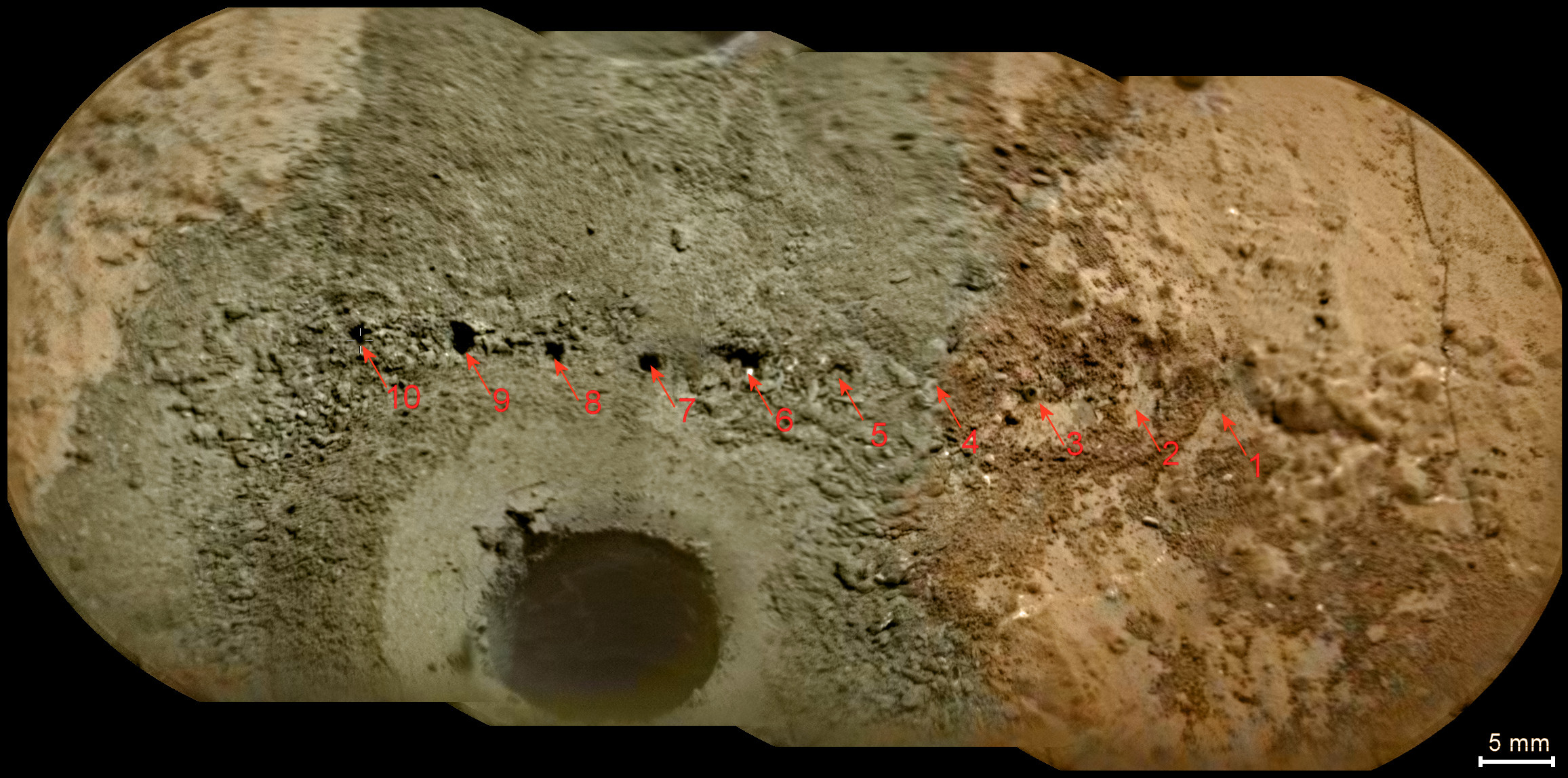
This self-portrait of NASA's Mars rover Curiosity combines 66 exposures taken by the rover's Mars Hand Lens Imager (MAHLI) during the 177th Martian day, or sol, of Curiosity's work on Mars (February 3, 2013).

The rover is positioned at a patch of flat outcrop called "John Klein," which was selected as the site for the first rock-drilling activities by Curiosity. The self-portrait was acquired to document the drilling site.

The rover's robotic arm is not visible in the mosaic. MAHLI, which took the component images for this mosaic, is mounted on a turret at the end of the arm. Wrist motions and turret rotations on the arm allowed MAHLI to acquire the mosaic's component images. The arm was positioned out of the shot in the images or portions of images used in the mosaic.

Photo credit: NASA/JPL-Caltech/MSSS

Note: For more information, see PIA16764: Curiosity Rover's Self Portrait at 'John Klein' Drilling Site, Cropped. This is the same image as above, but is cropped into a nice, rectangular shape and is also at a higher resolution (6.678 MB).

Sunday, February 10, 2013

Dunes in Brashear Crater


Today's VIS image shows part of the dune field on the floor of Brashear Crater.

Orbit Number: 49052 Latitude: -53.4147 Longitude: 240.117 Instrument: VIS Captured: 2013-01-04 (All day)

Photo credit: NASA/JPL-Caltech/Arizona State University

Frost Avalanches Along Olympia Rupes


This image was originally acquired in 2011 in order to monitor for frost avalanches that occurred the year prior.

HiRISE often re-images certain areas to track changes over time. In this case, we wanted to photograph the scarp near the onset of the Martian springtime, to get a better understanding of the frequency of these frost avalanches, what triggers them and any role they have in the evolution of the scarp's formation.

While HiRISE has captured other frost avalanches before, they never cease to amaze since it demonstrates that there are indeed active processes on the Red Planet.

Photo credit: NASA/JPL/University of Arizona

Saturday, February 9, 2013

Lava Flows in Daedalia Planum


Today's VIS image shows a small portion of the lava flows that make up Daedalia Planum.

Orbit Number: 48765 Latitude: -21.3017 Longitude: 240.492 Instrument: VIS Captured: 2012-12-11 09:06

Photo credit: NASA/JPL/Arizona State University

Layering in Central Candor Chasma


A Context Camera (CTX) image of this area shows faulted layered deposits near the contact between the layered deposits and wall rock.

At HiRISE resolution, we may be able to discern any structural relationships, which may yield insight into relative age of these layered deposits and faulting to basin formation. As part of a stereo pair (linked below), we can measure bedding and fault orientations.

This observation is in an area of high hematite abundance. On Earth, hematite is a mineral formed in an aqueous environment. Its presence on Mars can help us understand what the past environment was like that formed it.

This is a stereo pair with ESP_019732_1750.

Photo credit: NASA/JPL/University of Arizona

Friday, February 8, 2013

Meroe Patera Dunes


The dunes in this VIS image are located on the margin of Meroe Patera.

Orbit Number: 48870 Latitude: 6.65402 Longitude: 68.131 Instrument: VIS Captured: 2012-12-20 02:01

Photo credit: NASA/JPL-Caltech/Arizona State University

Layers in a Crater in Nilosyrtis


This impact crater in the Nilosyrtis region of Mars contains numerous layers exposed along its floor. These layers formed long after the impact event and are likely deposits of dust and ice.

Also present are dunes of dark sand that probably blew in from the surrounding terrain.

This is a stereo pair with ESP_025911_2255.

Photo credit: NASA/JPL/University of Arizona

Thursday, February 7, 2013

Channel in Tyrrhena Fossae


The channel feature in this VIS image is part of Tyrrhena Fossae, a large depression that dissects Tyrrhena Mons.

Orbit Number: 48882 Latitude: -20.2213 Longitude: 107.255 Instrument: VIS Captured: 2012-12-21 00:12

Photo credit: NASA/JPL-Caltech/Arizona State University

Conical Hill in Planum Australe


This image shows an odd pointy hill on the South Polar layered ice deposits.

The hill appears layered and may be an erosional remnant, in which most of the region been eroded to a depth of at least the height of this hill (about 20-30 meters), maybe more. The dark spots and streaks are due to defrosting of the seasonal cover of dry ice (carbon dioxide).

Photo credit: NASA/JPL/University of Arizona

Tuesday, February 5, 2013

Juventae Chasma Dunes


This VIS image shows the western margin of Juventae Chasma and the dunes that occur at the base of the chasma cliff.

Orbit Number: 48863 Latitude: -4.23348 Longitude: 297.286 Instrument: VIS Captured: 2012-12-19 10:35

Photo credit: NASA/JPL-Caltech/Arizona State University

Sunday, February 3, 2013

Textured Crater Floor in Arabia Terra


Surrounding the uplifted bedrock in the center of this large crater is mottled terrain. What possibly caused this?

The floor of the crater might be the result of icy flows. Perhaps an ancient aquifer system was exposed at the time of the impact resulting in the incredible mottled floor we see now, which appears different from the uplifted central peak.

Photo credit: NASA/JPL/University of Arizona

Note: This crater lies just to the north of Flammarion Crater in Arabia Terra.

Saturday, February 2, 2013

East Coprates Chasma Dune Fields and Wall Rock


One of the suggested goals for this observation was to investigate the relation of dune material with wall rock as a suspected sand source.

Outcrops emulating dark material are located upslope of the dune field. Adjacent HiRISE images (like PSP_007218_1660) show evidence that the dune material may be locally derived. Overlaps with other HiRISE images also help to monitor for change detection (dune slip faces and rock slides).

Coprates Chasma is part of the large Valles Marineris canyon, the largest one in the Solar System.

This is a stereo pair with ESP_025731_1655.

Photo credit: NASA/JPL/University of Arizona

Friday, February 1, 2013

Lucaya Crater Named

The USGS Astrogeology Science Center reports that:

The IAU Working Group for Planetary System Nomenclature has approved the name Lucaya for a crater on Mars. For more information, see the map of MC-21 in the Gazetteer of Planetary Nomenclature.

Note: Lucaya Crater is a small impact crater located on the northwestern rim of Huygens Crater, both of which are located in Terra Sabaea. It is named after a town in the Commonwealth of the Bahamas.


Diverse Mineral Compositions within Schaeberle Crater


This image covers a well-preserved (relatively young) impact crater about 5 kilometers (3 miles) wide. The enhanced-color sample shows that the north-facing slope (on the south side of the crater) has a blue-green color but the south-facing slope has a yellowish color.

The blue-green (infrared-shifted) colors indicate minerals like olivine and pyroxene, common in lava or subsurface intrusions of magma. The yellowish color is typical of hydrous alteration or dust. This crater likely exposed diverse lithologies (rock types) that were present before the crater formed.

This is a stereo pair with ESP_030290_1550.

Photo credit: NASA/JPL/University of Arizona

Note: The location of this photo is within Schaeberle Crater, which lies to the northwest of Hellas Planitia in Terra Sabaea.