Thursday, September 30, 2010

Polar Dunes in Hyperboreae Undae


By high summer, the extensive dune fields of the north polar region are completely defrosted and the number and variety of dunes are readily visible.

Photo credit: NASA/JPL/Arizona State University

Note: These dunes are located in Hyperboreae Undae, northeast of Escorial Crater.

Wednesday, September 29, 2010

Tikhonravov Crater


Tikhonravov Crater is a large, old crater in Terra Sabaea. The crater is pockmarked by numerous younger craters and other features. Today's VIS image shows a channel within Tikhonravov Crater.

Photo credit: NASA/JPL/Arizona State University

Layered Bedrock in Oyama Crater near Mawrth Valles


Layered rock exposed in Oyama Crater in HiRISE image ESP_016829_2040 provides information about bedding style and expression immediately beneath the ground at the candidate Mars Science Laboratory (MSL) field site next to Mawrth Vallis.

This new observation on the west wall of the same crater further reveals these layered rocks for comparison with what we see on the north wall. These images serve to characterize the geologic setting of the potential landing site and rover explorations.

MSL is expected to launch in late 2011, landing on Mars in 2012. Mawrth Vallis is one of four candidate landing sites.

Photo credit: NASA/JPL/University of Arizona

Ejecta Blanket in Meridiani Planum


The ejecta blanket created around impact craters is often much more resistant to erosion than the surrounding surface materials. In this case of a crater near Meridiani Planum the ejecta material is creating isolated highs as the surrounding surface is eroded.

Photo credit: NASA/JPL/Arizona State University

Note: This location is northeast of Crommelin Crater.

Tuesday, September 28, 2010

Aurorae Chaos


Located at the eastern end of Valles Marineris is the region of chaos called Aurorae. Today's VIS image is from the northern part of Aurorae Chaos and contains mesas separated by complex low lying regions.

Photo credit: NASA/JPL/Arizona State University

Slope Streak South of Olympus Mons


This observation reveals slope streaks in an area south of Olympus Mons in the northern hemisphere of Mars.

These features are found along the slopes of impact craters, buttes, knobs, ridges, and troughs on Mars. Streaks generally start at a point source and widen downslope, traveling over and sometimes around various obstacles.

The subimage shows a very wide dark slope that has developed small fingers at its terminus. The dark slope streak does not appear to have relief and does not disturb the pre-existing surface leaving the underlying topography intact beneath its dark trail. This can be seen particularly well near the streak termination. There are also no observable deposits of displaced materials along the terminus.

Surrounding the dark slope streak are multiple 1 meter deep, triangular faceted scars left behind from avalanched slope materials. The high standing remnant surfaces on either side of the lower scarred surface are clearly visible. Avalanche scars are sometimes found in areas where slope streaks have formed but they are believed to be unrelated. The trail of the dark slope streak appears to cross over the avalanche scars suggesting that the slope streak formed more recently.

Slope streak formation is among the few known processes currently active on Mars. While their mechanism of formation and triggering is debated, they are most commonly believed to form by downslope movement of extremely dry sand or very fine-grained dust in an almost fluidlike manner (analogous to a terrestrial snow avalanche) exposing darker underlying material.

Other ideas include the triggering of slope streak formation by possible concentrations of near-surface ice or scouring of the surface by running water from aquifers intercepting slope faces, briny liquid flows, dry granular flow, mixed water-dust flows, and/or hydrothermal activity.

Photo credit: NASA/JPL/University of Arizona

Note: The location of this image is in the lowlands east of Gordii Dorsum.

Gullies in Utopia Planitia


Small gullies mark the rim of this unnamed crater in Utopia Planitia.

Photo credit: NASA/JPL/Arizona State University

Monday, September 27, 2010

Dark Slope Streaks in Terra Sabaea


Today's VIS image shows dark slope streaks in an unnamed crater in Terra Sabaea.

Photo credit: NASA/JPL/Arizona State University

Note: This tiny crater lies between two much larger craters (also unnamed), the edges of which can be seen on the left and right. These craters, in turn, lie about halfway between Tikhonravov Crater, to the north, and Janssen Crater, to the south.

Layers in Galle Crater


This image shows part of a large mass of layered rock in Galle Crater, in the southern cratered highlands of Mars.

At low resolution, layers appear as bands and swirls which are nearly horizontal. This causes them to interact dramatically with topography, producing the appearance of folds and loops wrapping around small hills much like lines on a contour map. Zooming in at higher resolution, some long cracks (hundreds of meters long) are cutting across the layers, generally trending northeast-southwest.

At full resolution, details of the layers are often obscured by ripples of wind-blown dust or textured patterns of erosion now eroding the rock. In the best exposures, such as that in the cutout section the layers are fractured into blocks. Some of the layers are relatively resistant, and appear as ridges or fins in the cutout, often with little material supporting them from below. Although this seems to indicate relatively strong, coherent material, few boulders are visible. The ridge-forming layers may be weak, but separated by material with virtually no cohesion.

Polygonal fracture patterns in the dark regolith between distinct layers could be due to ground ice, or regional tectonic stresses.

Photo credit: NASA/JPL/University of Arizona

Moreux Crater Dunes


Today's VIS image shows some of the dunes of the floor of Moreux Crater.

Photo credit: NASA/JPL/Arizona State University

Sunday, September 26, 2010

Evros Vallis and Nearby Craters


This image shows part of Evros Vallis, one of the Martian valley networks.

These more ancient valley networks may have been eroded by flowing water during a warmer, wetter period of Martian history. Many dunes are visible along the valley floor, as well as throughout the scene and in a partially exhumed crater on the valley wall. There are multiple generations and orientations of dunes. Dune orientation reflects the dominant or prevailing wind direction. Multiple dune orientations indicate that this region has experienced different wind regimes.

An exhumed crater is one that likely formed a long time ago, was buried, and is now being re-exposed because the materials that originally covered it are being eroded away. The prominent crater on the valley wall as well as several other craters in this scene are thought to be partially exhumed.

The subimage shows a couple groups of secondary craters. Secondary craters are craters that form when ejecta from the primary crater hits the surface with enough energy to form another smaller crater. As seen in the subimage, secondary craters often form in clusters spatially, because ejecta thrown out of the primary crater impacts the surface near each other at approximately the same time.

Many potential secondary craters have have similar morphologies and have distinct, bright ejecta. This implies that these craters are relatively young and that their ejecta have yet to be covered by dust.

Photo credit: NASA/JPL/University of Arizona

Note: Evros Vallis is located in the northern region of Noachis Terra, and is south of Schiaparelli Crater.

Chaos Terrain Near Nili Fossae


On Mars, the term 'chaos' terrain is given to regions where areas of the surface are broken up into multiple mesas divided by low valleys. Channels in regions of chaos indicate that fluids played a part in the formation of these regions. Today's VIS image shows a channel within a region of chaos NW of Nili Fossae.

Photo credit: NASA/JPL/Arizona State University

Collapse Features of Olympica Fossae


The depressions in this VIS image likely formed due to both volcanic and tectonic forces. Tectonic forces, like faulting, probably account for the formation of some of the depressions, while collapse into lava tubes and lava flow erosion probably account for the remainder.

Photo credit: NASA/JPL/Arizona State University

Note: These troughs are all part of Olympica Fossae.

Saturday, September 25, 2010

Clouds over Sand Dunes


Clouds are common near the north polar cap throughout the spring and summer. The clouds typically cause a haze over the extensive dune fields. This VIS image shows the edge of the cloud front.

Photo credit: NASA/JPL/Arizona State University

Note: These dunes are located in Olympia Undae north of Dokka Crater.

Friday, September 24, 2010

Eridania Planitia

From the USGS Astrogeology Science Center:

The name Eridania Planitia has been approved for the Martian feature located at 38S, 238W. For more information, see the database information and the maps of MC-28 and MC-29 in the Gazetteer of Planetary Nomenclature.

Notes: Eridania Planitia is located east of Hellas Planitia in the northern Promethei Terra highlands. Two prominent craters in the Eridania Planitia region are Arrhenius Crater and Greg Crater. The name was approved on September 22, 2010. There are now a total of ten named planitae on Mars.

Monday, September 20, 2010

A Brief Discontinuity in the Space-Time Continuum

This is a quick note to say that my home is going through some renovation work through early next week. Blogging is more or less halted until then, although, if I can find some time to do some posts, I'll try to put up some new material. In the meantime, please feel free to visit the archives of Areology, Ministry of Space Exploration, and Saturnology.

Wednesday, September 15, 2010

Arabia Terra


Small unnamed channels drain the surface in this region of Arabia Terra.

Photo credit: NASA/JPL/Arizona State University

Alluvial Fan in Far Western Terra Tyrrhena


This image shows portions of an alluvial fan complex in Harris Crater, an approximately 83-kilometer diameter crater located on the northern rim of the Hellas Basin.

An alluvial fan is a fan-shaped accumulation of loose, water-transported material deposited where an upland drainage emerges into a low-relief basin. In this case, two source regions on the northern crater rim fed discrete lobe deposits that make up the alluvial fan complex. These lobes have different surface textures that enable researchers to map out the different components of the fan and investigate the sequence of fan-building processes that operated in the past.

The fan surfaces have experienced erosional degradation, presumably the result of wind. One interesting result of this is the formation of "inverted channels," where the former channel floors are now preserved as ridges. Tributary channels on the alluvial fan were armored by coarse gravels or chemically cemented, making the channel bottoms resistant to erosion. Over time, natural erosion from wind and other processes left the inverted channels elevated above the surrounding terrain. The inverted channels record the former flow direction. Differences in channel orientation point to different source regions. In this subimage, inverted channels from one source region are identified by black arrows, while a second flow orientation (marked by white arrows) that originated from a different source.

A rugged surface texture, outlined in white, is on top of some of the inverted channels. This material is a late-stage deposit in the formation of this alluvial fan complex. The HiRISE image shows that this material is boulder-rich, which suggests the material was transported in a debris flow (a sediment-concentrated slurry of material).

The preserved landforms record episodic fan formation (different portions of the fan were active at different times) resulting from different fluid flow processes. The transition from fluvial to late-stage debris flow(s) suggests a decline in available water and/or change in sediment supply. In-depth geologic investigations, such as this one, help refine our understanding of the relative timing and necessary climatic conditions required at the time this alluvial fan formed.

Photo credit: NASA/JPL/University of Arizona

Tuesday, September 14, 2010

Dark Slope Streaks


Dark slope streaks abound in this VIS image. The unnamed craters in this image are located east of Henry Crater.

Photo credit: NASA/JPL/Arizona State University

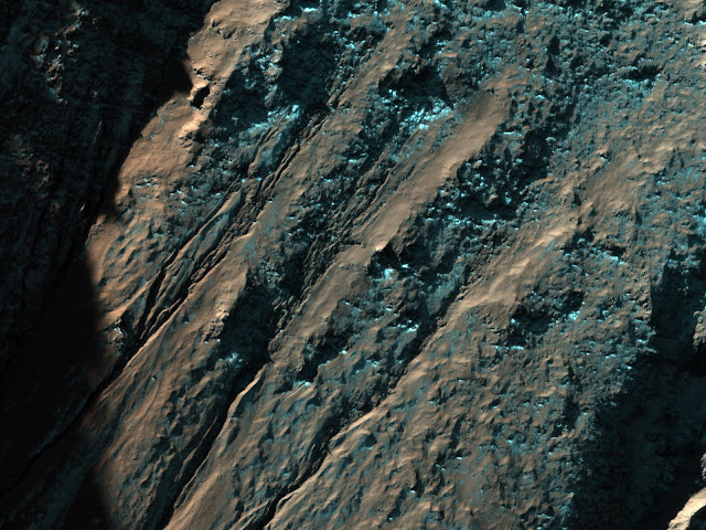
Gullies and Seasonal Frost in a Crater


This scene shows the curving, eastern interior walls of a 12 kilometer-diameter (approximately 7.4 mile-diameter) impact crater in the Southern mid-latitudes of Mars.

The Sun is off-scene to the northwest (left in the map-projected images), causing the northwestern wall to cast a shadow far into the deep crater interior. This shadowing effect also highlights the gullies incised into the northern wall of the crater. Many ideas have been advanced as to how such gullies form - some appear to have involved flowing water, perhaps from melting ice, while others appear to be formed solely due to mass wasting of soil and rocks.

In the enhanced-color strip down the middle of this image, the northern wall displays some bluish-purplish coating, which is seasonal frost that remains deposited on such steep slopes facing away from the equator at this time of year, much like frost often accumulates first, or disappears last, from mountain slopes on Earth that face away from the equator (north-facing in the Northern Hemisphere, and south-facing in the Southern Hemisphere).

Photo credit: NASA/JPL/University of Arizona

Note: The small crater in this photo is located west of Martz Crater in Terra Cimmeria.

Monday, September 13, 2010

Uzboi Vallis


This VIS image shows the western wall of Uzboi Vallis near the intersection of the vallis and Holden Crater. Many channels dissect the wall of the channel.

Photo credit: NASA/JPL/Arizona State University

Sunday, September 12, 2010

Mantling Material on Crater Floor


This image shows remnants of a mantling deposit on the floor of a crater in the southern highlands of Mars.

The slope up towards the crater rim is visible in the lower right part of the image. The rough, hummocky texture may be related to loss of ice from material that was once ice-rich.

One goal of this image was to investigate the parallel lines that are visible around several of the large hummocks and hills in the image's center. We'd like to determine whether these are layers that are present throughout the rock, or whether they are merely on the surface. In the first case, these may be the expression of buried bedrock layers. However, it is also possible that these are related to the mantling deposits, perhaps representing variations in the mantle.

At high resolution, the lines appear to be small ridges, that are either buried by or composed of the mantling material. In the best exposures, these ridges look like the edges of layers of the mantling material that was draped over the entire region and then eroded off the high places. This suggests the second hypothesis: we are probably seeing variations in the mantle, perhaps due to multiple cycles of material being laid down.

Photo credit: NASA/JPL/University of Arizona

Note: The crater in this image is the crater directly adjacent to the southwest rim of Hartwig Crater in Noachis Terra, which lies to the northeast of Argyre Planitia.

Arsia Mons Lava Flows


This VIS image shows a portion of the lava flows associated with Arsia Mons.

Photo credit: NASA/JPL/Arizona State University

Note: This photo is almost identical to a previous THEMIS picture Areology highlighted back in April.

Saturday, September 11, 2010

Labeatis Fossae


The channel-like features in this VIS image are fault bounded down-dropped blocks of material. These tectonic features are called Labeatis Fossae and are located on the eastern margin of the Tharsis Volcanic complex.

Photo credit: NASA/JPL/Arizona State University

Alluvial Fan along a Crater Wall


This observation covers an alluvial fan along the wall of a large crater in the mid latitudes of the Southern hemisphere of Mars.

The fan was formed when water and sediments drained down the steep wall of the crater creating a cone-shaped pile of debris at the base. As the fan grew with time, the channels carrying water and sediment across the fan surface changed locations, producing a layered deposit capped by channels radiating from the fan apex along the crater wall.

Subsequent stripping of the fan surface by the wind has left the coarser channel deposits in relief and exposed the fine scale layering within the fan in many locations. While is it is not known whether the source of the water responsible for creating the fan was related runoff from precipitation or groundwater or perhaps both, alluvial fans of broadly similar form are observed in many locations on Earth and are usually formed by runoff from precipitation.

Photo credit: NASA/JPL/University of Arizona

Note: The larger crater in which this smaller crater is located is in the uplands northwest of Terra Cimmeria. These craters are to the southwest of Herschel Crater.

Friday, September 10, 2010

Meridiani Planum


Parts of Meridiani Planum have a surface that appears to be composed of different layers of material. In this VIS image the contrast of bright and dark materials indicates the different layers.

Photo credit: NASA/JPL/Arizona State University

Valleys on the Ejecta Blanket from Cerulli Crater


This HiRISE image reveals valleys that cross the ejecta from the large impact crater Cerulli to the south.

The valleys appear to have been cut by flowing water and then buried by later deposits of unknown origin, possibly carried in by the wind. While it is clear that the valleys are younger than the ejecta and older than at least some of the mantling materials, the exact time they were formed is uncertain.

For example, it is possible that the valleys were carved immediately after Cerulli Crater formed, as has been inferred for some other valleys around craters imaged elsewhere on Mars by HiRISE. Alternatively, the valleys may have formed some time after the crater formed, perhaps as a result of water released from an earlier mantling deposit.

Photo credit: NASA/JPL/University of Arizona

Thursday, September 9, 2010

North Polar Dunes (Again)


As the Sun warms the surface and more frost is removed, the dunes and other features near the north pole of Mars are revealed. This VIS image shows that the inter-dune areas are complex.

Photo credit: NASA/JPL/Arizona State University

Note: The location of these dunes is to the south of Olympia Undae and to the east of Olympia Mensae.

Cambridge Bay Outcrop


This panorama taken by NASA's Mars Exploration Rover Opportunity includes an outcrop informally called "Cambridge Bay." Opportunity examined this outcrop in August 2010. The outcrop includes an apparent contact between two bedrock units which have different textures and perhaps compositions.

Opportunity used its navigation camera during the 2,335th Martian day, or sol, of the rover's mission on Mars (August 18, 2010) to take these images. Science instruments on the robotic arm were used to measure the chemistry and texture of the outcrop from Sol 2340 (August 24, 2010) to Sol 2346 (August 30, 2010). Opportunity has since resumed its journey toward the long-term destination of Endeavour Crater. Portions of Endeavour Crater's rim are visible on the horizon.


Photo credit: NASA/JPL-Caltech

Wednesday, September 8, 2010

North Polar Dunes


The appearance of the dunes in the North Polar Erg (or sand sea) changes as the seasons move from winter to summer. This summer image shows the dunes totally free of frost.

Photo credit: NASA/JPL/Arizona State University

Note: These dunes are located near the eastern tip of Olympia Undae. The closest named feature to this location is Rupes Tenuis, which is to the north. Rupes Tenuis is part of the southernmost cliffs of Planum Boreum.

Two Craters South of Sirenum Fossae


This image shows two craters in the southern hemisphere just south of Sirenum Fossae.

The northern crater is smaller, appears more degraded, and is partially filled with sediments that form a hummocky surface. Dunes have formed subsequently on this surface. Some incipient gully-like features have formed midway along the southern crater wall and expose layers that are more resistant to erosion.

The larger crater to the south is eroded by gullies on its northern slope while the southern slope region lacks them. Most gullies in this scene appear to emanate from more resistant layers, although the larger gullies have eroded back almost to the crater rim.

The nature of the layers and their connection to the water that formed the gullies is unknown. Gullies typically form when flowing water erodes sediments and soft rocks in a channelized flow. Because Mars is very cold and dry, it is unknown where the water came from to form the gullies.

Photo credit: NASA/JPL/University of Arizona

Tuesday, September 7, 2010

Nili Patera Dunes


The dunes in this VIS image are located in Nili Patera, one of the two patera of Syrtis Major Planum.

Photo credit: NASA/JPL/Arizona State University

Of Polar Pits and Gullies


This image features the north wall and floor of a polar pit in the southern hemisphere.

The pit wall is sculpted into a row of gullies. Gullies typically have a triangular start upslope, followed by a channel that transported material, and a triangular debris fan downslope. Polar pit gullies might be related to seasonal changes in frost coverage, but their exact origin is currently unknown. The gullies appear bright because they probably have seasonal frost on them.

The pit floor contains a field of dark sand dunes. Wind has transported sand across the Martian surface, and it was deposited in this pit and formed dunes. Some of the sand in the dunes might have come from the gully debris fans or other erosion of the pit wall.

The bright material within the dunes and along the floor is seasonal frost that is probably composed of carbon dioxide and water ice.

Photo credit: NASA/JPL/University of Arizona

Note: This pit is located in Sisyphi Cavi.

Monday, September 6, 2010

Moreux Crater Dunes


This VIS image shows small individual dunes on the floor of Moreux Crater.

Photo credit: NASA/JPL/Arizona State University

Valleys Carved into Elysium Mons


This image is of the flanks of the shield volcano Elysium Mons.

The volcano is considered to be the youngest within the Elysium Mons province, which also contains the volcanoes Hecates Tholus and Albor Tholus.

Of course, "young" is a relative term. The last eruption of Elysium Mons could well have been a billion years or more ago.

This image shows a series of flat bottomed valleys along the flanks of Elysium Mons. There is considerable debate on exactly how these valleys form. In Hawaii, the classic example of shield volcanoes on Earth, similar valleys are carved by prodigious rainfall. While some rain may have fallen in the earliest epochs of Mars' geologic history, the lack of small drainage networks shows that these Martian channels were not carved by rain.

However, mudflows and lava flows could potentially erode the sides of the volcano. An important hint for the origin of the valleys comes from the chain of pits visible in the northern part of the image. These pits form as the ground is pulled apart by Marsquakes. Thus it seems that many of these valleys are first formed by movement along faults. Then mud and/or lava flows widen the sides of the valley and give it a flat floor.

Photo credit: NASA/JPL/University of Arizona

Sunday, September 5, 2010

Wind Effects South of Olympus Mons


This VIS image of an area south of Olympus Mons shows a region where the wind has been an active agent in modifying the surface. Small linear dunes cover the surface in this image.

Photo credit: NASA/JPL/Arizona State University

Coordinated MER Spirit and MRO HiRISE Imaging Campaign


One of the science objectives of this observation was to try to capture the same dust devil in both cameras simultaneously by coordinated HiRISE and MER Spirit observations.

Surprisingly few dust plumes and dust devil tracks have been observed by HiRISE in Gusev Crater, in comparison to the number of dust devils seen by the rover. Obtaining both ground-based and orbital imagery will allow scientists to better understand the formation, physical properties, and behavior of the dust devils at the MER Spirit landing site.

During these coordinated observations, Spirit observed several small dust devils and a large dust devil in the flat plains northwest of its current position on the western scarp of a polygonal feature commonly called Home Plate. On the other hand, the HiRISE camera did not detect an active dust devil nor the track that dust devils often leave behind. However, a dust devil plume was captured east of Columbia Hills that was about 17 meters in diameter! The top “L-curve” is the track left behind, and the bottom “L-curve” is the shadow of the plume. With changing winds, the dust devil is moving in a direction different than when it formed. It may be that only the largest of the Gusev Crater dust devils can be easily seen by HiRISE.

BACKGROUND
Ground-based (Mars Exploration Rover) MER and orbital MRO (Mars Reconnaissance Orbiter) HiRISE observations indicate that the low albedo zone in Gusev Crater is currently an active area for the formation of dust devils.

Dust devils are convecting warm-core vortices that form when hot surface air rises and is replaced by the radial inflow of surrounding cool air. This rising vertical column of swirling warm air creates a low pressure core. The low pressure core acts like a vacuum that picks up fine particles that mantle the surface and exposes the dark basaltic substrate in a narrow track.

Photo credit: NASA/JPL/University of Arizona
Subimage credit: Devin Waller, Arizona State University (for Spirit coordination)

Saturday, September 4, 2010

Moreux Crater Dunes


This VIS image shows some of the dunes located on the floor of Moreux Crater.

Photo credit: NASA/JPL/Arizona State University

Central Peak Gullies of Lohse Crater


This image is of the eastern half of the central peak of Lohse Crater located in the southern hemisphere.

The crater itself is highly degraded and is roughly 80 miles in diameter. Of specific interest are the pristine looking gullies that appear to have sourced from layers below the top of this uplifted region.

Smaller gullies appear to emanate in all directions from the uplifted region, but of special interest is the larger gully located on the northern most slope of the central peak. This gully has a larger alcove and a better developed debris apron than surrounding gullies. This implies that either this gully formed over a longer time period or that more fluid was involved in its formation.

Gullies are present on many slopes on Mars, especially between the latitudes of 30 and 70 degrees in both hemispheres. Gullies are formed by fluids and have three distinct parts to them: an eroded “alcove” at the top, a sometimes sinuouschannel” section, and finally a large “debris apron” where the material eroded by the gully is deposited.

This image forms part of an anaglyph with ESP_013071_1365.

Photo credit: NASA/JPL/University of Arizona

Friday, September 3, 2010

Tinto Vallis


The wide channel in this VIS image is Tinto Vallis.

Photo credit: NASA/JPL/Arizona State University

Note: Tinto Vallis is a channel 180 kilometers long that flowed into the southern part of Palos Crater. Both Palos Crater and Tinto Vallis are south of Amenthes Planum.

Ramparts in Tooting Crater


This image is of the ejecta blanket of the Tooting Crater in the northern hemisphere of Mars.

Tooting is a "rampart" crater that is roughly 29 kilometers (18 miles) in diameter and appears to be one of the youngest craters of this size. A rampart crater is one where the material ejected from the crater during impact forms lobes that end with a low ridge, or rampart. One indication of Tooting Crater's youth is its ratio of depth to width. As a crater ages, the walls of the crater will tend to erode and debris will accumulate in the crater's floor making its apparent depth less, while also making its width larger.

One of the major features of Tooting Crater are its multiple ejecta layers that build a sequence of ramparts. The shapes of these ramparts suggest that the ejected material acted as a fluid (like mud) as it moved across the surface. Most researchers think that such fluid ejecta indicates that there was ice in the ground when the crater formed.

Photo credit: NASA/JPL/University of Arizona

Note: The above photo along with this one form an anaglyph image.

Thursday, September 2, 2010

Dust Devil Tracks in Arcadia Planitia


The dark lines in this VIS image are the tracks of dust devils in this region of Arcadia Planitia. As the swirling winds move along the surface, they remove the dust cover, revealing the darker rock beneath.

Photo credit: NASA/JPL/Arizona State University

Defrosting in Inca City


This image shows a region known as "Inca City" near the south pole, so named because its rectilinear grid of ridges is reminiscent of the ruins of an ancient city.

Of course, these ridges are not tumble-down stone walls, but their origin is not known for certain. The ridges most likely have been exhumed by aeolian stripping of overlying material and are not related in origin to the nearby south polar ice deposits.

One possible formation scenario is the filling of cracks (perhaps produced on the floor of an impact crater) by erosionally-resistant material, such as volcanic rock. Now, the ridges are muted by overlying material, most likely dust. In this image, taken in southern spring, the ridges are also covered by seasonal carbon dioxide ice. The dark spots are areas where the ice is translucent enough to see the darker material beneath it and/or where darker material beneath the ice has escaped to the surface and is blown by near-surface winds, creating long, dark streaks.

This image is one in a series of images positioned near this location for the purpose of monitoring these dark spots and streaks throughout southern spring and early summer to ascertain how they form and change as the seasonal ice disappears.

Photo credit: NASA/JPL/University of Arizona

Note: Inca City is located in the very southern reaches of Cavi Angusti, just north of Planum Australe.

Wednesday, September 1, 2010

Olympus Mons Flows


Many surface lava flows on the flanks of Olympus Mons are confined to narrow channels, like the ones in today's VIS image.

Photo credit: NASA/JPL/Arizona State University

Area Traversed by the Mars Exploration Rover


This digital terrain model covers the area that has been explored by the Mars Exploration Rover "Opportunity" on Meridiani Planum. It provides topographic data that have been very useful in Opportunity mission planning.

For example, the part of the DTM covering Victoria Crater was used in conjunction with rover observations to select a safe place to enter the crater. This subimage shows a perspective view of HiRISE color data laid over the DTM of Victoria crater, looking north. The selected entry point is at far left in this view, dubbed "Duck Bay."

Credit: NASA/JPL/University of Arizona/USGS