Friday, January 31, 2014

Ascraeus Mons


Today's image shows a different portion of the collapse features located on the northern flank of Ascraeus Mons.

Orbit Number: 53309 Latitude: 13.6999 Longitude: 256.956 Instrument: VIS Captured: 2013-12-20 09:06

Photo credit: NASA/JPL-Caltech/Arizona State University

Dingo Gap


This scene combines images taken by the left-eye camera of the Mast Camera (Mastcam) instrument on NASA's Curiosity Mars rover during the mid-afternoon, local Mars solar time, of the mission's 526th Martian day, or sol (January 28, 2014). The sand dune in the upper center of the image spans a gap, called "Dingo Gap," between two short scarps. The dune is about 3 feet (1 meter) high. The nearer edge of it is about 115 feet (35 meters) away from the rover's position when the component images were taken, just after a Sol 526 drive of 49 feet (15 meters).

The image has been white-balanced to show what the rocks would look like if they were on Earth. A version with 200-centimeter (79-inch) scale bars is available as Figure A. A version with raw color, as recorded by the camera under Martian lighting conditions, is available as Figure B.

Image credit: NASA/JPL-Caltech/MSSS

Note: For more information, see PIA17763: Full-Circle Vista During Curiosity's Approach to 'Dingo Gap', PIA17764: Full-Circle Vista During Curiosity's Approach to 'Dingo Gap' (Stereo), PIA17765: Traverse Map for Mars Rover Curiosity as of January 26, 2014, PIA17767: Crystal-Laden Martian Rock Examined by Curiosity's Laser Instrument and Curiosity Mars Rover Checking Possible Smoother Route.

Thursday, January 30, 2014

Ascraeus Mons


The pits, fractures and channel-like features in this image are located on the northern flank of Ascraeus Mons. Most of these features were created by collapse into lava tubes that existed below the surface.

Orbit Number: 53284 Latitude: 13.1863 Longitude: 257.591 Instrument: VIS Captured: 2013-12-18 07:44

Photo credit: NASA/JPL-Caltech/Arizona State University

Opportunity Traverse Map for Cape York


A region known as "Cape York" on the western rim of Endeavour Crater, where NASA's Mars Exploration Rover Opportunity worked for 20 months, is highlighted in these images.

The inset at upper left is a portion of a false-color image taken by the High Resolution Imaging Science Experiment (HiRISE) camera on NASA's Mars Reconnaissance Orbiter. The black outline shows the "Matijevic Hill" region, enlarged in the central image. Initial traverses accomplished by Opportunity to evaluate the geologic setting of the region are noted. The Opportunity team was interested in this region because the Compact Reconnaissance Spectrometer for Mars (CRISM) on NASA's Mars Reconnaissance Orbiter showed a specific type of clay mineral called a ferric smectite. This type of clay mineral originally formed in groundwater along fractures in which the water was only mildly acidic.

The lower left inset shows a portion of CRISM data centered on Cape York. The red region delineates where CRISM spectra show features diagnostic of the smectite clay mineral.

This image is from a portion of a HiRISE observation cataloged as ESP_032573_1775 . Other products from the same observation are available at http://hirise.lpl.arizona.edu/ESP_032573_1775.

Image credit: NASA/JPL-Caltech/University of Arizona

Wednesday, January 29, 2014

Alba Fossae


Today's VIS image shows a portion of Alba Fossae, located on the northwestern margin of Alba Mons. Small channels are also visible.

Orbit Number: 53322 Latitude: 45.2895 Longitude: 247.241 Instrument: VIS Captured: 2013-12-21 10:36

Photo credit: NASA/JPL-Caltech/Arizona State University

Montmorillonite Deposit in Rock at Cape York


Researchers used NASA's Mars Exploration Rover Opportunity to find a water-related mineral [Montmorillonite] on the ground that had been detected from orbit, and found it in the dark veneer of rocks on the rim of Endeavour Crater.

This false-color view from the panoramic camera (Pancam) on Opportunity shows a dark veneer, exposed after brushing with the rover's rock abrasion tool. These finely layered rocks with dark veneers are in the "Whitewater Lake" outcrop on "Matijevic Hill" on the western rim of Endeavour. The deposits are part of the ancient Matijevic formation, which predates the Endeavour impact event. The brushed area is about 1.5 inches (3.8 centimeters) wide. This image was taken on the 3,098th Martian day, or sol, of Opportunity's mission (October 11, 2012).


Photo credit: NASA/JPL-Caltech/Cornell University/Arizona State University

Note: For more information, see PIA17756: 'Esperance6' and 'Lihir' Rover Targets and PIA17757: Mineral Plot from 'Esperance' Target.

Tuesday, January 28, 2014

Labeatis Fossae


The fractures in this VIS image are part of Labeatis Fossae. The large impact crater was formed after the fractures.

Orbit Number: 53283 Latitude: 32.1022 Longitude: 289.185 Instrument: VIS Captured: 2013-12-18 05:39

Photo credit: NASA/JPL-Caltech/Arizona State University

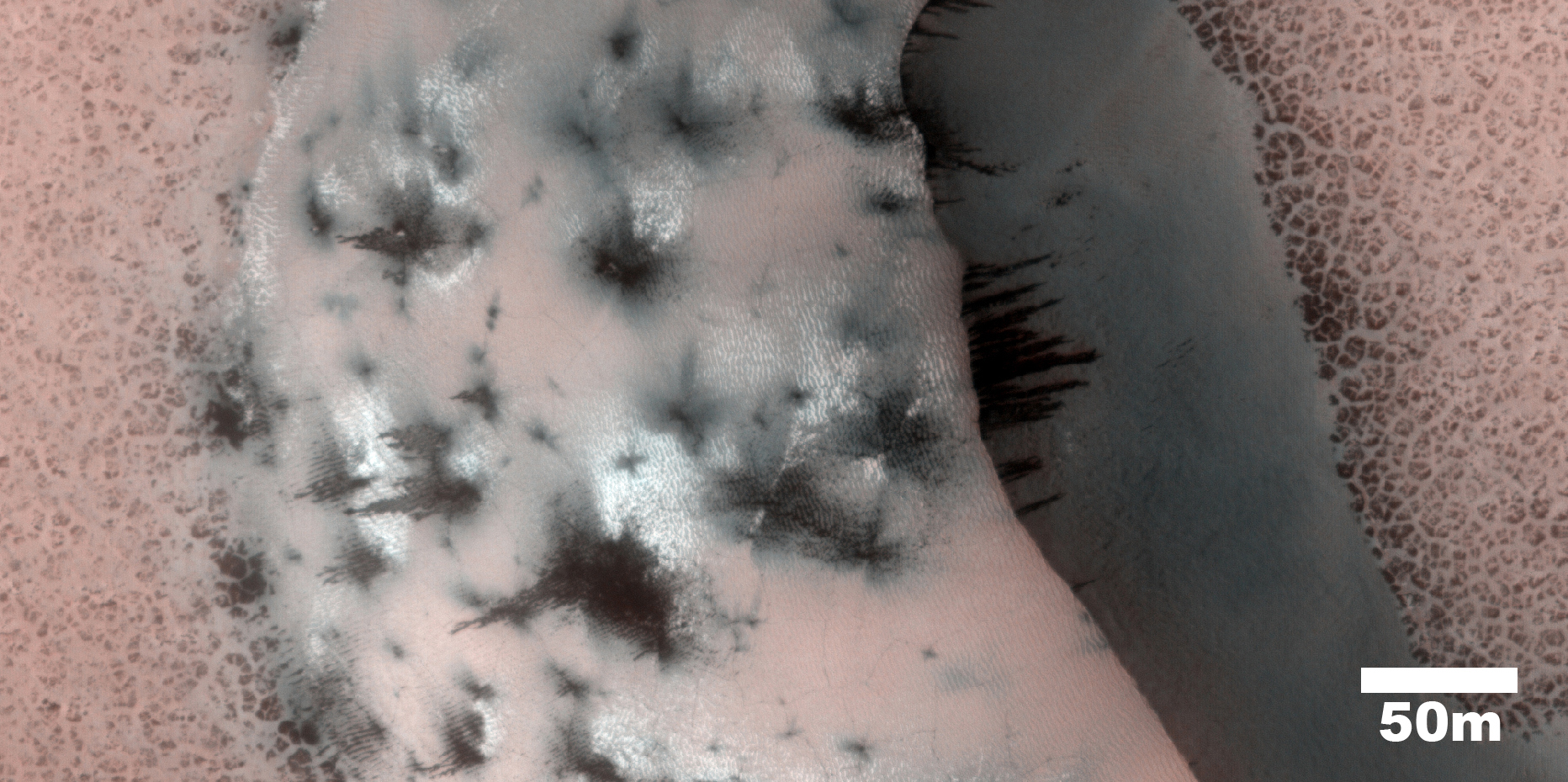
Frost and Geyser Marks on a Dune South of Planum Boreum


This image shows numerous dark shapes and bright spots on a sand dune in the Northern polar regions of Mars.

The bright spots are carbon dioxide frost. On Mars, the main atmospheric component is carbon dioxide, which circulates seasonally between the atmosphere and the polar regions. One of the reasons that permit this process is the fact that temperatures on Mars are much colder than on Earth, which allows carbon dioxide frost to condense on the surface in winter.

When spring comes however, the surface heats up and the carbon dioxide frost eventually sublimates (turns directly from the solid to the vapor state), and forms jets of carbon dioxide mixed with dust, leading to the formation of the dark features we see in the image.

Such processes occur seasonally on Mars, and therefore are continuously being monitored by the HiRISE scientists to assess the differences from one year to the next.

Photo credit: NASA/JPL/University of Arizona

Note: This dune is located in Vastitas Borealis just south of Planum Boreum.

Monday, January 27, 2014

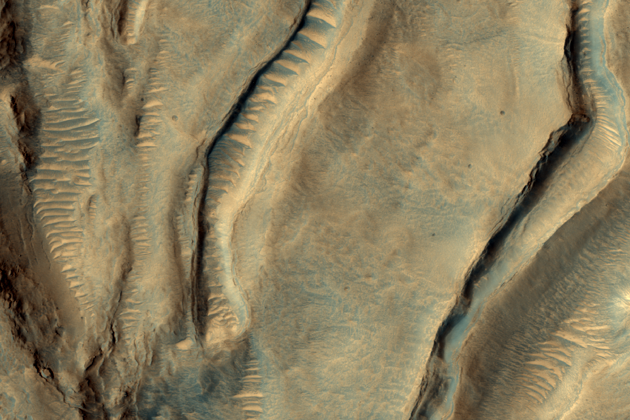
Light-Toned Deposits in Coprates Chasma


Valles Marineris contains kilometers-thick light-toned layered sedimentary deposits along many of its floors. In this image, similar light-toned layered deposits are observed, except these are found along steeper wallrock slopes in Coprates Chasma.

Compositional data from CRISM and also stereo images—which we use to create 3D images—can help scientists determine how these sediments were deposited and if they are the same as the thicker deposits seen along the chasma floors.

Photo credit: NASA/JPL/University of Arizona

Sunday, January 26, 2014

Oxus Patera Collapse Feature


Oxus Patera is an ancient, eroded depression in northern Arabia Terra. It is not known how Oxus Patera formed, though it has been suggested that the feature represents an ancient caldera formed through collapse and explosive volcanism.

Other possibilities include formation by impact and erosion, or collapse due to removal of subsurface volatiles. Regardless of how the massive depression originally formed, there is little doubt that the feature has been modified by younger ice-related processes.

This image shows an unusual landform on the floor of Oxus Patera. Notice an irregular, scalloped contact trending diagonally from southwest to northeast near the center of the image. The terrain in the upper left is likely composed of fine-grained, weakly consolidated materials because it does not form many topographic features within the unit (few mesas, buttes, mountains, etc.). Where it is eroded, it does not form boulders: it appears to be an easily crumbled, blanketing deposit. The terrain in the lower right is very unusual. It contains smooth surfaces marked by small, irregularly shaped cones and fractures that are bounded by upturned ridges. The boundary between the two terrains consists of scalloped fractures that appear to have formed where the terrain in the lower right has detached from the terrain in the upper left, and partially collapsed.

Photo credit: NASA/JPL/University of Arizona

Saturday, January 25, 2014

Cerberus Fossae and Athabasca Valles


The fractures in this VIS image are part of a large system of fractures called Cerberus Fossae. Athabasca Valles is visible in the lower right corner of the image.

Orbit Number: 53141 Latitude: 19.8044 Longitude: 61.0929 Instrument: VIS Captured: 2013-12-06 13:16

Photo credit: NASA/JPL-Caltech/Arizona State University

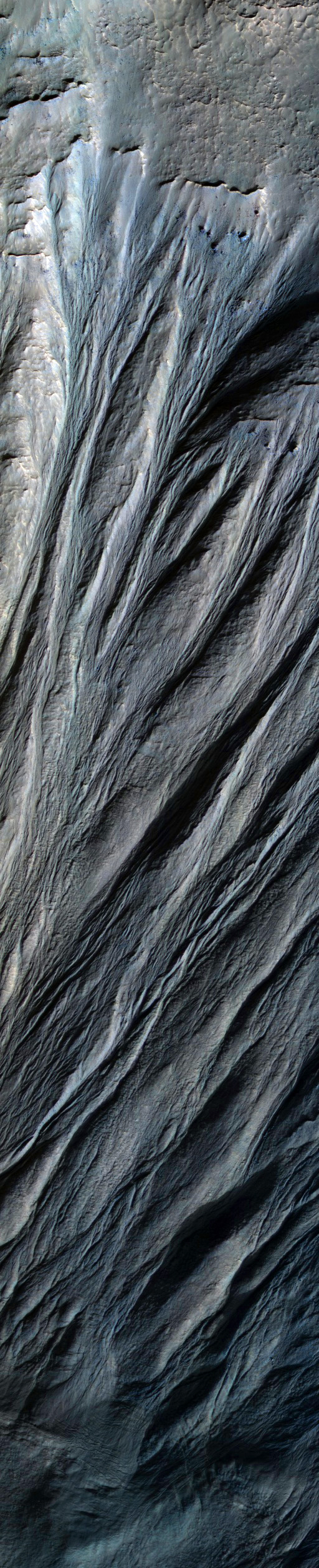
Giant Gullies North of Argyre Planitia


This image shows gullies that are large even by Mars standards, and much larger than the terrestrial landforms we call gullies. The length of some of these is over 6 kilometers (3.6 miles).

They are located on large mountains located north of the Argyre impact basin. An enhanced color view (reduced scale) shows only subtle color differences.

Photo credit: NASA/JPL/University of Arizona

Friday, January 24, 2014

Dust Devil Tracks in Antoniadi Crater


This VIS image shows a portion of the floor of Antoniadi Crater. The faint, dark marks may be dust devil tracks.

Orbit Number: 53141 Latitude: 19.8044 Longitude: 61.0929 Instrument: VIS Captured: 2013-12-06 13:16

Photo credit: NASA/JPL-Caltech/Arizona State University

Opportunity's January 2014 Self-Portrait


NASA's Mars Exploration Rover Opportunity recorded the component images for this self-portrait about three weeks before completing a decade of work on Mars. The rover's panoramic camera (Pancam) took the images during the interval January 3, 2014, to January 6, 2014, a few days after winds removed some of the dust that had been accumulating on the rover's solar panels.

Opportunity landed on Mars on January 25, 2004, Universal Time (January 24, 2004, PST) for a mission that was planned to last three months. It is still active 10 Earth years later.

This image is presented as a vertical projection. The mast on which the Pancam is mounted does not appear in the image, though its shadow does.

Image credit: NASA/JPL-Caltech/Cornell University/Arizona State University

Note: For more information, see PIA17758: Opportunity's First Decade of Driving on Mars and NASA's Opportunity at 10: New Findings from Old Rover.

Wednesday, January 22, 2014

Labeatis Fossae


The fractures in this VIS image are part of Labeatis Fossae.

Orbit Number: 53096 Latitude: 25.6028 Longitude: 279.278 Instrument: VIS Captured: 2013-12-02 20:22

Photo credit: NASA/JPL-Caltech/Arizona State University

Pinnacle Island


This before-and-after pair of images of the same patch of ground in front of NASA's Mars Exploration Rover Opportunity 13 days apart documents the arrival of a bright rock onto the scene. The rover had completed a short drive just before taking the second image, and one of its wheels likely knocked the rock -- dubbed "Pinnacle Island" -- to this position. The rock is about the size of a doughnut.

The images are from Opportunity's panoramic camera (Pancam). The one on the left is from 3,528th Martian day, or sol, of the rover's work on Mars (December 26, 2013). The one on the right, with the newly arrived rock, is from Sol 3540 (January 8, 2014). Much of the rock is bright-toned, nearly white. A portion is deep red in color. Pinnacle Island may have been flipped upside down when a wheel dislodged it, providing an unusual circumstance for examining the underside of a Martian rock.

The site is on "Murray Ridge," a section of the rim of Endeavour Crater where Opportunity is working on north-facing slopes during the rover's sixth Martian winter.

Image credit: NASA/JPL-Caltech/Cornell University/Arizona State University

Tuesday, January 21, 2014

Olympia Undae


This VIS image shows a portion of the north polar dune field where there has been more frost lost from the dunes, so they appear darker than the dunes in PIA17865.

Orbit Number: 53077 Latitude: 79.9901 Longitude: 128.365 Instrument: VIS Captured: 2013-12-01 06:32

Photo credit: NASA/JPL-Caltech/Arizona State University

Note: This image is located in Olympia Undae.

Sunday, January 19, 2014

Dunes on the Western Rim of the Hellas Planitia


Sand dunes like these seen in this image have been observed to creep slowly across the surface of Mars through the action of the wind. These are a particular type of dune called a “barchan”, which forms when the wind blows in one direction (here, east to west) for long periods of time. Barchan dunes are common on Mars and in the desert regions of the Earth.

These barchan dunes are located on the western rim of the Hellas impact basin, in the Southern Hemisphere of Mars. This area is covered by extensive deposits of layered rocks that were initially deposited as loose sediments and over time formed these rock layers. Portions of these layered rocks were subsequently eroded away and the remaining layers now form numerous flat-topped hills called “mesas”. The barchan dunes are forming in the lee (or downwind) of the mesas.

This area was previously image by HiRISE in 2008 and was retargeted here through a public request via HiWish. Careful comparison of repeat images such as these can reveal the speed and manner by which dunes move across the Martian surface. This information can be used to study the current atmosphere of Mars, the age and mobility of sand deposits on the planet’s surface, and the hazards that sand dunes may pose to landed vehicles such as rovers.

Over the course of its mission, the science instruments on board the Mars Reconnaissance Orbiter (MRO) have returned over 200 terabits of data back to Earth. This image was taken on November 4, 2013, the same day that MRO’s 200-terabit mark was surpassed.

Photo credit: NASA/JPL/University of Arizona

Note: For more information, see PIA17873: Dunes on the Rim of the Hellas Impact Basin.

Saturday, January 18, 2014

Olympia Undae


This VIS image shows dunes near the north polar cap of Mars. It is springtime at the north pole and the dunes are starting to lose their frost cover. As the season continues towards summer the dunes will appear darker and darker as the frost sublimates.

Orbit Number: 53076 Latitude: 80.2675 Longitude: 157.439 Instrument: VIS Captured: 2013-12-01 04:34

Photo credit: NASA/JPL-Caltech/Arizona State University

Note: This image is located in Olympia Undae.

Salt Deposits in Terra Cimmeria


Why are scientists interested in areas that contain salts on Mars? Simply put, salts usually form by evaporation of liquid water. Most salts can easily dissolve in water, and if that water evaporates away completely, the salt is left behind as a deposit or residue. The larger the amount of salts initially dissolved, the larger the salt deposit left behind when the water evaporates. So when scientists look for regions on Mars that have noticeable salt deposits, they are effectively looking for areas that may have contained liquid water in the past.

A few years ago, a group of scientists found more than 600 locations on Mars that may contain chloride salts, which could be very similar to common table salt. Since then, scientists have been using the HiRISE camera to look at these locations more closely and they have found out that many of these locations are very similar to dried lakes on Earth, which are sometimes called “playas” or “salt pans.” Many such playas can be visited in California and Arizona such as the Racetrack playa and the Death Valley National Park.

In this image, the chlorides have a bright appearance and are covered by other dark materials. Interestingly, the bright deposits also display cracks that form polygonal patterns very similar to common mud cracks, which may be another indication that these deposits formed when salty waters evaporated away. Studying these regions in detail can help scientists understand when and how the weather conditions on Mars may have changed.

Photo credit: NASA/JPL/University of Arizona

Note: These salt deposits are located in Terra Cimmeria, northwest of Morpheos Rupes. For more information, see PIA17875: Looking for Salts on Mars.