Saturday, November 30, 2013

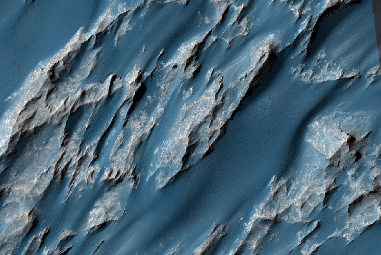
Lava Channel East of Olympus Mons


The channel in the bottom part of this VIS image was created by lava flow rather than water flow. This feature is located in the Tharsis plains east of Olympus Mons.

Orbit Number: 52423 Latitude: 20.9613 Longitude: 240.14 Instrument: VIS Captured: 2013-10-08 11:01

Photo credit: NASA/JPL-Caltech/Arizona State University

Friday, November 29, 2013

Rubicon Valles


Today's VIS image shows part of Rubicon Valles located on the northwestern flank of Alba Mons.

Orbit Number: 52423 Latitude: 44.6535 Longitude: 244.022 Instrument: VIS Captured: 2013-10-08 11:00

Photo credit: NASA/JPL-Caltech/Arizona State University

Thursday, November 28, 2013

Surface Textures Southeast of Aeolis Planum


The surface textures in this VIS image located southeast of Aeolis Planum likely had wind action as one of the contributing processes.

Orbit Number: 52402 Latitude: -7.56114 Longitude:150.354 Instrument: VIS Captured: 2013-10-06 15:59

Photo credit: NASA/JPL-Caltech/Arizona State University

Wednesday, November 27, 2013

Nicholson Crater


This VIS image shows part of the large deposit on the floor of Nicholson Crater.

Orbit Number: 52387 Latitude: 0.130557 Longitude: 194.999 Instrument: VIS Captured: 2013-10-05 12:18

Photo credit: NASA/JPL-Caltech/Arizona State University

Tuesday, November 26, 2013

Hydraotes Chaos


The ridges and mesas in this VIS image are part of Hydraotes Chaos.

Orbit Number: 52370 Latitude: 1.85829 Longitude: 325.257 Instrument: VIS Captured: 2013-10-04 02:43

Photo credit: NASA/JPL-Caltech/Arizona State University

Monday, November 25, 2013

Textured Mesa Southeast of Bosporus Planum


Also imaged by MRO's Context Camera, this observation shows one of two odd, rounded mesas with a knobby/pitted texture.

This mesa may be the last remnants of a formerly more extensive geologic unit. Given the particular pitted texture, this formation could be ice-rich.

High resolution images can greatly help to characterize the surface texture and allow us to compare other mid-latitude-type landforms, which may have some connection with ice and sublimation degradation processes.

Photo credit: NASA/JPL/University of Arizona

Note: These mesas are located southeast of Bosporus Planum. For more information, see PIA17703: A Textured Mesa.

Sunday, November 24, 2013

Intersection of Fractures in Echus Chasma


In this image, we see an intersection of several fractures on the floor of Echus Chasma. One "sector" appears to have been filled by a more recent viscous lava flow.

Echus Chasma is considered to be the water source region that formed Kasei Valles, a large valley that extends thousands of kilometers to the north. HiRISE may help determine the relative roles of lava and water in the region.

Photo credit: NASA/JPL/University of Arizona

Note: For more information, see PIA17704: Martian Intersection.

Saturday, November 23, 2013

Coprates Chasma


Today's VIS image shows part of Coprates Chasma.

Orbit Number: 52347 Latitude: -13.3246 Longitude: 295.016 Instrument: VIS Captured: 2013-10-02 03:24

Photo credit: NASA/JPL-Caltech/Arizona State University

Nirgal Vallis Tributaries


Nirgal Vallis is one of the largest and longest valley networks on Mars (approximately 400 kilometers in length). Oriented roughly east-west and located north of the Argyre impact basin, its western region contains numerous short, theater-headed tributaries that merge into a long, sinuous, and deeply entrenched main valley that extends eastward to Uzboi Vallis.

The area in this image (centered at -27.1730 latitude, 313.7340 longitude) is of the western most tributaries. Valley heads are steep and abrupt with blunt terminations. Although Nirgall Vallis formed long ago, likely by flowing water, abundant wind-blown sediments transformed into the dune fields that now line the valley floors. However, the distinctive valley pattern shape with steep walls and flat floors led many to propose that ground water flowed out to the surface along the valley heads and walls of the numerous tributaries. This process, known as sapping, begins with ground water flowing along subsurface fractures or permeable layers and carrying out sediments with it as it emerges at the cliff face.

Eventually, the loss of support from beneath undermines the cliff face, causing it to slump into the valley. With continued sapping, tributaries grow progressively in a headward direction. This kind of erosion is common in the Colorado Plateau of the Southwestern United States and helped form the distinctive shape of the Grand Canyon. Wrinkle ridges intersecting several tributaries may have provided additional avenues for ground water flow into the valley system.

Photo credit: NASA/JPL/University of Arizona

Note: For more information, see PIA17701: Nirgal Vallis Tributaries.

Friday, November 22, 2013

Gale Crater


This VIS image of Gale Crater shows the region of the crater that is "home" to the Curiosity Rover.

Orbit Number: 52340 Latitude: -4.58873 Longitude: 137.411 Instrument: VIS Captured: 2013-10-01 13:32

Photo credit: NASA/JPL-Caltech/Arizona State University

Hydrated Sulfate Landslides in Ophir Chasma


Giant landslides in Ophir Chasma host a variety of geologic surfaces and mineralogies. Some possess a variety of hydrated sulfate minerals that formed in the presence of partially acidic liquid water.

This image of an ancient, approximately 3 billion year-old landslide shows two distinct surface albedos, which are proportions of reflected light. These different toned surfaces also mark a transition from one sulfate mineralogy to another and variations in surface evolution.

The upper slopes to the north are light-toned due to an abundance of hydrated sulfate minerals and bright surface dust. The surfaces that make up the southern portions of the landslide are darker in tone due to the greater frequency of dark sediment that form strings of sand drifts. Additionally, the underlying units of bedrock consist of darker minerals with less hydration then those to the north, implying a change in the ancient aqueous environments that formed them.

Photo credit: NASA/JPL/University of Arizona

Note: For more information, see PIA17702: Hydrated Sulfate Landslides in Ophir Chasma.

Thursday, November 21, 2013

Iani Chaos


Several different surface textures are present on the lower elevations of Iani Chaos.

Orbit Number: 52283 Latitude: -0.827418 Longitude: 341.65 Instrument: VIS Captured: 2013-09-26 20:57

Photo credit: NASA/JPL-Caltech/Arizona State University

Murray Ridge on the Rim of Endeavour Crater


This scene shows the "Murray Ridge" portion of the western rim of Endeavour Crater on Mars. The ridge is the NASA's Mars Exploration Rover Opportunity's work area for the rover's sixth Martian winter.

The ridge rises about 130 feet (40 meters) above the surrounding plain, between "Solander Point" at the north end of the ridge and "Cape Tribulation," beyond Murray Ridge to the south. This view does not show the entire ridge. The visible ridge line is about 10 meters (33 feet) above the rover's location when the component images were taken.

The scene sweeps from east to south. The planar rocks in the foreground at the base of the hill are part of a layer of rocks laid down around the margins of the crater rim. At this location, Opportunity is sitting at the contact between the Meridiani Planum sandstone plains and the rocks of the Endeavour Crater rim. On the upper left, the view is directed about 22 kilometers (14 miles) across the center of Endeavour crater to the eastern rim.

Opportunity landed on Mars in January 2004 and has been investigating parts of Endeavour's western rim since August 2012.

The scene combines several images taken by the panoramic camera (Pancam) on NASA's Mars Exploration Rover Opportunity during the 3,446th Martian day, or sol, of the mission's work on Mars (October 3, 2013) and the following three sols. On Sol 3451 (October 8, 2013), Opportunity began climbing the ridge. The slope offers outcrops that contain clay minerals detected from orbit and also gives the rover a northward tilt that provides a solar-energy advantage during the Martian southern hemisphere's autumn and winter.

The rover team chose to call this feature Murray Ridge in tribute to Bruce Murray (1931-2013), an influential advocate for planetary exploration who was a member of the science teams for NASA's earliest missions to Mars and later served as director of NASA's Jet Propulsion Laboratory, in Pasadena.

This view is presented in approximately true color, merging exposures taken through three of the Pancam's color filters, centered on wavelengths of 753 nanometers (near-infrared), 535 nanometers (green) and 432 nanometers (violet).

Image credit: NASA/JPL-Caltech/Cornell/Arizona State University

Note: For more information, see PIA17583: 'Murray Ridge' on Rim of Endeavour Crater on Mars, False Color, PIA17585: Opportunity's View Climbing 'Murray Ridge', PIA17586: A New Perspective on Murray Ridge, PIA17588: 'Murray Ridge' in Stereo from Mars Rover Opportunity, and Mars Rover Teams Dub Sites in Memory of Bruce Murray.

Wednesday, November 20, 2013

Wind Streaks in Syrtis Major Planum


This image shows several wind streaks in Syrtis Major Planum.

Orbit Number: 52279 Latitude: 9.12948 Longitude: 69.5053 Instrument: VIS Captured: 2013-09-26 14:58

Photo credit: NASA/JPL-Caltech/Arizona State University

Ismeniae Fossae Perspective


Branches in the 2 km-wide trough of Ismeniae Fossae are seen in close-up detail in this scene. Material in the channels likely derived from the walls subsequently transported by glaciers or water flowing through the region. Smaller dendritic valley systems formed by water – possibly from melting ice – are seen at the bottom left and in the upper right portion of the image. The clusters of circular to elliptical depressions in the bottom left may be either secondary impact craters from debris flung out by larger impact craters, or collapse pits caused by the sublimation of subsurface ice.

This region was imaged by the High Resolution Stereo Camera on ESA’s Mars Express on 16 June 2013 (orbit 11709), with a ground resolution of about 20 m per pixel. The scene is located at approximately 40°N / 42°E.

Photo credit: ESA/DLR/FU Berlin (G. Neukum)

Tuesday, November 19, 2013

Lava Flows in Daedalia Planum


This VIS image shows a small portion of the lava flows that comprise Daedalia Planum.

Orbit Number: 52274 Latitude: -22.4732 Longitude: 238.098 Instrument: VIS Captured: 2013-09-26 03:18

Photo credit: NASA/JPL-Caltech/Arizona State University

Ismeniae Fossae


This scene shows a section of Ismeniae Fossae that straddles the southern highlands–northern lowlands of Mars. The 2 km-wide curvilinear trough that runs through this image contains numerous parallel grooves and ridges comprising material from the trough walls and material that has been dragged along the floor by ancient glaciers and ice-rich flows.

In the left portion of the scene the channel truncates a roughly 25 km-wide crater. Material in the crater walls has slumped down into the channel, smoothing over the grooved floor.

Around this crater, and elsewhere in Ismeniae Fossae, clusters of circular to elliptical, partially interconnected depressions are observed. These may be either secondary impact craters from debris flung out by larger impact craters, or collapse pits caused by the sublimation of subsurface ice.

The western portion of the 138 km-wide Moreux Crater is seen in the bottom right of the image. Numerous small dendritic valley systems west of the crater provide further evidence of water flowing in this region at some point in the Red Planet’s past, perhaps as water melting from the ice thought to have once covered this region.

The image was taken by the High Resolution Stereo Camera on ESA’s Mars Express on 16 June 2013 (orbit 11709), with a ground resolution of about 20 m per pixel. The image centre is at approximately 40°N / 42°E.

Photo credit: ESA/DLR/FU Berlin (G. Neukum)

Monday, November 18, 2013

Impact Crater with Ring Trough in Utopia Rupes


Does this observation show a possible proto-pedestal crater?

This crater has a ring trough, but the inner circle around the crater does not appear significantly elevated. Why did the ring around the crater collapse before anything else? Could it be an example of ice sublimating from below the surface?

A high resolution image shows us better details, as we can see in this close-up.

Photo credit: NASA/JPL/University of Arizona

Sunday, November 17, 2013

Lava Rafts in Athabasca Valles


This image covers part of the Athabasca Valles flood lava plain, the youngest large lava flow on the surface of Mars.

At this location, there are two rafted pieces of lava crust with strange infrared properties. Compared to the rest of the lava flow, these two raised areas are cold at night and warm in the day. This property of the surface, where the temperature changes quickly, is called "low thermal inertia." Rocks tend to have relatively high thermal inertia, so this is unexpected.

This image confirms speculation from earlier, lower resolution images. The rafts are composed of broken up (brecciated) lava, forming an extraordinarily rough surface. Normally, such a jagged pile of lava rocks would have high thermal inertia. But in this location, the rough surface has served as a trap for wind-carried dust. Thus in these rafts, and only in these rafts, is the lava covered by a thick pile of fluffy dust.

Such dust is extremely insulating, meaning that all the solar heating is deposited in a very thin layer near the surface. Therefore, dust gets relatively hot during the day. Because the heat is deposited so shallowly, it is easily lost at night. So, the trapped dust is the explanation for the low thermal inertia of these lava rafts.

Photo credit: NASA/JPL/University of Arizona

Saturday, November 16, 2013

Wind Streaks in Syrtis Major Planum


Today's VIS image shows wind streaks in Syrtis Major Planum.

Orbit Number: 52254 Latitude: 5.90248 Longitude: 69.7373 Instrument: VIS Captured: 2013-09-24 13:03

Photo credit: NASA/JPL-Caltech/Arizona State University