Sunday, April 13, 2014

Butte Remaining at Possible Fissure Vent South of Ascraeus Mons


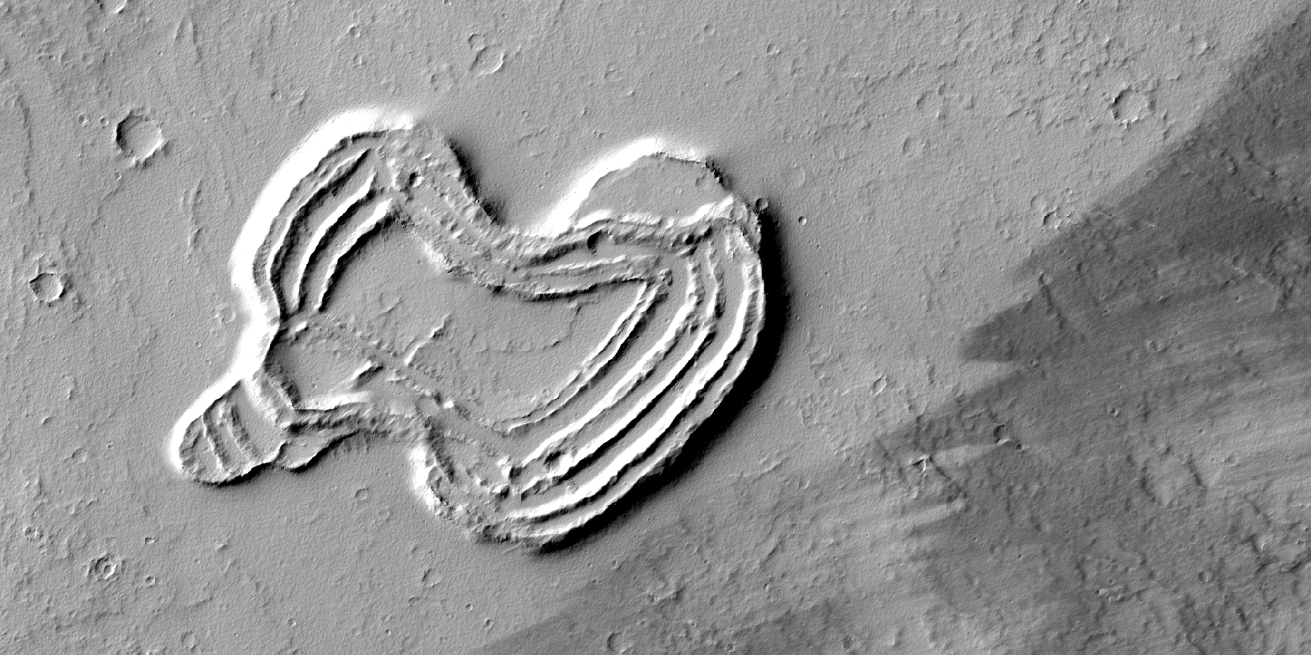
What is this strange-looking feature? HiRISE scientists first noticed it in images from the Context Camera and acquired this picture to investigate more closely.

The feature indeed does look like a heart. It is located south of Ascraeus Mons, which is a large volcano within the Tharsis volcanic plateau, so it is extremely likely that this feature was formed by a volcanic process. The feature rises above the surrounding terrain and we can see concentric ridges on its top. Perhaps this feature is an ancient vent structure (an opening in the ground from which volcanic lava emerges) that has been more resistant to erosion than the surrounding area, so that it resembles “inverted” terrains.

Topographic inversion or inverted terrain often occurs when low areas of a landscape become filled with lava or sediments that harden into materials which are more resistant to erosion than the materials that surround them. Differential erosion then removes the less resistant surrounding material, leaving behind the younger resistant material which may then appear as a ridge where previously there was a valley, or in our case, a butte, where there was once a pit or depression.

Additional imaging of the feature to create a stereo and a digital terrain model may help in further assessing the structure by making accurate measurement of its height and the steepness of its slopes.

Photo credit: NASA/JPL/University of Arizona

Saturday, April 12, 2014

Channel in Nili Fossae


This complex channel is located in the Nili Fossae region.

Orbit Number: 54027 Latitude: 22.7189 Longitude: 78.748 Instrument: VIS Captured: 2014-02-17 11:05

Photo credit: NASA/JPL-Caltech/Arizona State University

Osuga Valles


The central portion of Osuga Valles, which has a total length of 164 km. In some places, it is 20 km wide and plunges to a depth of 900 m. It is located approximately 170 km south of Eos Chaos, which is located at the periphery in the far eastern portion of the vast Valles Marineris canyon system.

Catastrophic flooding is thought to have created the heavily eroded Osuga Valles, which displays streamlined islands and a grooved floor carved by fast-flowing water. The water flowed in a northeasterly direction (towards the bottom right in this image) and eventually drained into another region of chaotic terrain, just seen at the bottom of the image.

Several large impact craters are also seen in this scene, including the ghostly outline of an ancient, partially buried crater in the bottom center of the image.

The image was created using data acquired with the High Resolution Stereo Camera on Mars Express on 7 December 2013 during orbit 12,624. The image resolution is about 17 m per pixel and the image center is at about 15ºS / 322ºE.

Image credit: ESA/DLR/FU Berlin

Note: For more information, see Osuga Valles in Context, Osuga Valles in 3D, Perspective View of Osuga Valles, and Osuga Valles Topography.

Friday, April 11, 2014

Olympia Undae


The sand dunes in this VIS image are part of Olympia Undae, a huge sand sea located near the north polar cap.

Orbit Number: 54011 Latitude: 78.4383 Longitude: 198.938 Instrument: VIS Captured: 2014-02-16 03:10

Photo credit: NASA/JPL-Caltech/Arizona State University

Opportunity at Murray Ridge


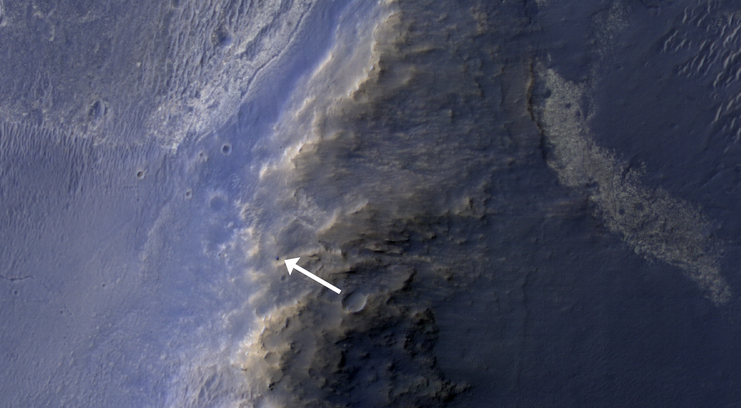
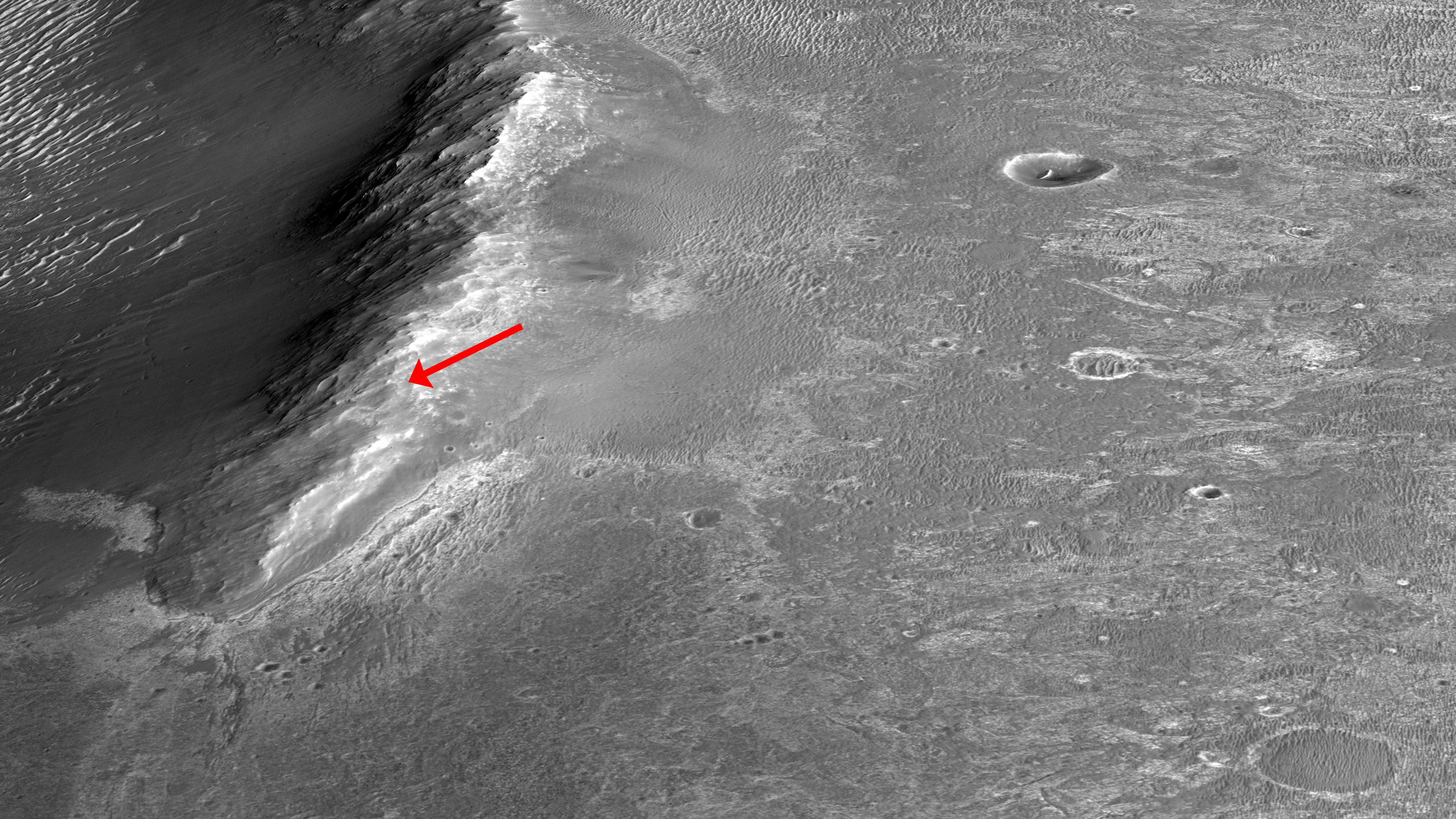
This HiRISE image of the Opportunity rover was acquired as a coordinated “ride-along” observation with the CRISM instrument, also onboard the Mars Reconnaissance Orbiter. The CRISM instrument is a spectrometer that views the surface in many wavelengths beyond what the human eye can detect, allowing for mineral identification of the Martian surface.

HiRISE images can be used to construct digital terrain models (or DTM), like the one of Endeavour Crater’s western rim, which provides high-resolution topography for landing site support. This southward prospective view was built using that DTM.

The use of CRISM mineralogy, along with topography and fine-scale images from HiRISE will aid in Opportunity's investigation into the geologic history of the Murray Ridge of Endeavour Crater.

Photo credit: NASA/JPL/University of Arizona

Thursday, April 10, 2014

Wind Streak East of Olympus Mons


The windstreak in this VIS image is located on Tharsis volcanic lava flows east of Olympus Mons.

Orbit Number: 54009 Latitude: 20.7725 Longitude: 237.425 Instrument: VIS Captured: 2014-02-15 23:33

Photo credit: NASA/JPL-Caltech/Arizona State University

Wednesday, April 9, 2014

Patapsco Vallis


Today's VIS image shows a portion of Patapsco Vallis, located on the eastern margin of the Elysium volcanic complex.

Orbit Number: 53987 Latitude: 23.4305 Longitude: 152.015 Instrument: VIS Captured: 2014-02-14 04:05

Photo credit: NASA/JPL-Caltech/Arizona State University

Bright Spot in the Distance at Gale Crater


This image from the Navigation Camera (Navcam) on NASA's Curiosity Mars rover includes a bright spot near the upper left corner. The sun is in the same direction, west-northwest, above the frame. Bright spots appear in images from the rover nearly every week. Typical explanations for them are cosmic rays hitting the light detector or sunlight glinting from rocks.

The right-eye camera of the stereo Navcam recorded this frame during the afternoon of the 589th Martian day, or sol, of Curiosity's work on Mars (April 3, 2014), from the site where the rover reached a waypoint called "the Kimberley" by that sol's drive. An image taken by the Navcam's left-eye camera within one second of the same time (http://mars.jpl.nasa.gov/msl/multimedia/raw/?rawid=NLB_449790582EDR_F0310000NCAM00262M_&s=589) does not include a bright spot of this type. A pair of Navcam images in the same direction from the previous afternoon has a bright spot similarly located in the right-eye image (http://mars.jpl.nasa.gov/msl/multimedia/raw/?rawid=NRB_449700848EDR_F0301254NCAM00252M_&s=588) but not in the left-eye image (http://mars.jpl.nasa.gov/msl/multimedia/raw/?rawid=NLB_449700848EDR_F0301254NCAM00252M_&s=588).

One possible explanation for the bright spot in this image is a glint from a rock surface reflecting the sun. Another is a cosmic ray hitting the camera's light detector, a CCD (charge-coupled device). Cosmic ray patterns in Mars rover images vary from a dot to a long line depending on the angle at which the ray strikes the detector.

Photo credit: NASA/JPL-Caltech

Note: For more information, see Images From NASA Mars Rover Include Bright Spots.

Tuesday, April 8, 2014

Graben in Labeatis Fossae


The depressions in this VIS image are graben that make up part of Labeatis Fossae. Graben are tectonic features comprised of a fault bounded depression where the central block of material has been downdropped between the two faults.

Orbit Number: 53970 Latitude: 27.2178 Longitude: 282.723 Instrument: VIS Captured: 2014-02-12 18:29

Photo credit: NASA/JPL-Caltech/Arizona State University

Ring of Rootless Cones in Elysium Planitia


In the center of this observation, we see a ring of cones that have developed over a crater rim. Lava appears to have deflated around and within the ring.

Interestingly, the area around the ring has few cones: did water or steam flow to the crater and make that zone less fertile? These cones are likely "rootless cones," so named because they do not form as a result of direct magma supply, but from the interaction of lava and water or ice in the substrate. The rootless cones in this image may have formed around the crater rim because the lava was thin there.

This is a stereo pair with ESP_034808_2065.

Photo credit: NASA/JPL/University of Arizona

Note: These rootless cones are located in northeastern Elysium Planitia to the southeast of Lockyer Crater.

Monday, April 7, 2014

Candidate Landing Site in Gusev Crater for Mars 2020 Rover


As we did for Phoenix in 2008 and the Mars Science Laboratory in 2012, HiRISE has been imaging landing sites for a potential rover mission in 2020.

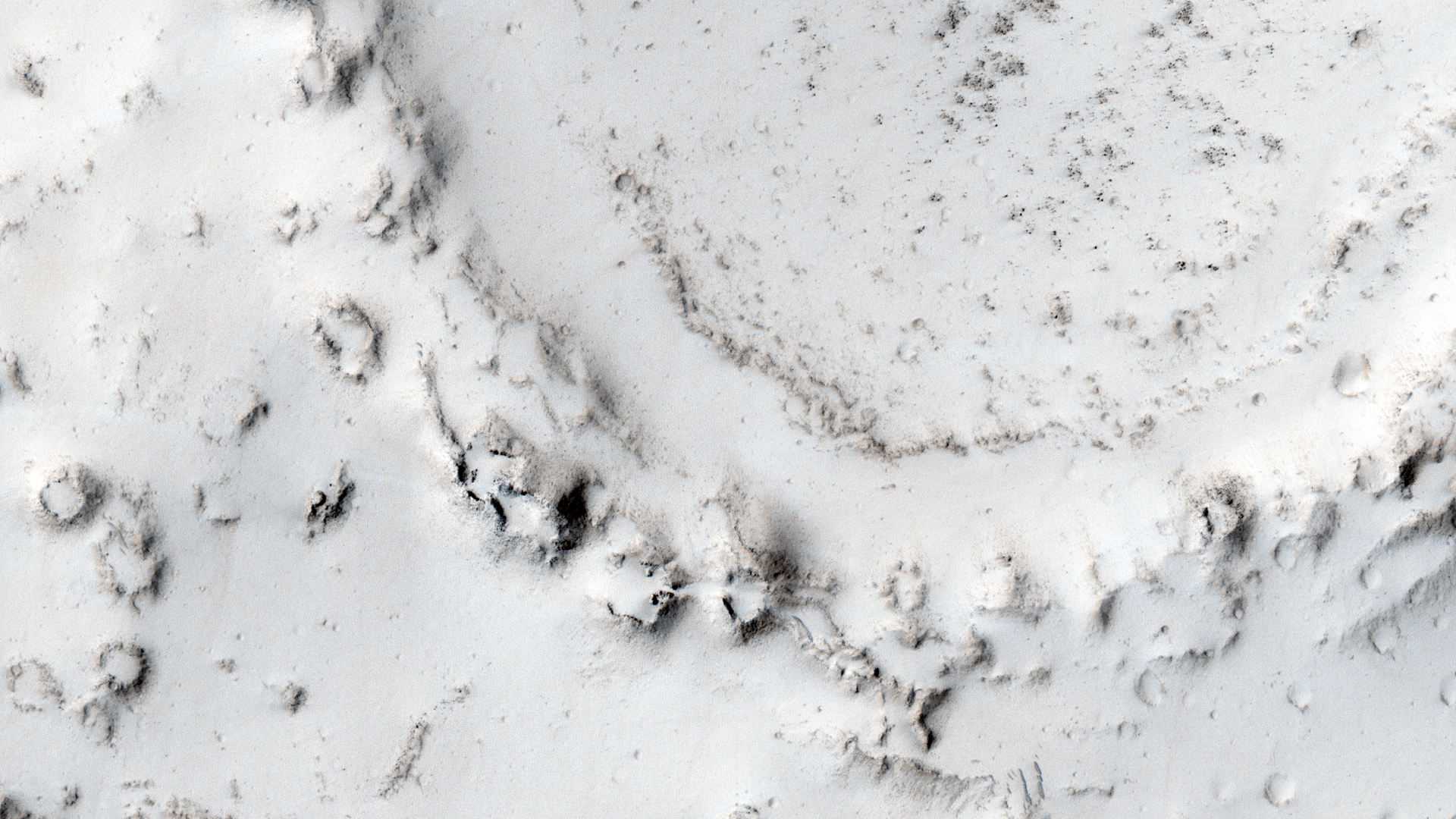
With HiRISE resolution, mission teams can examine what areas of Mars are flat enough to touchdown safely and also investigate the terrain to satisfy scientific research goals. Gusev Crater, a massive and ancient impact crater, was also the landing site for the rover Spirit in January 2004.

With this image, the science rationale was to investigate nearby opaline silica, carbonates and other aqueous phases.

Photo credit: NASA/JPL/University of Arizona

Sunday, April 6, 2014

The Kimberley


NASA's Curiosity Mars rover recorded this view of various rock types at a waypoint called "the Kimberley" shortly after arriving at the location during the 589th Martian day, or sol, of the rover's work on Mars (April 2, 2014). The Kimberley was selected in 2013 as a major waypoint for the mission because of the diversity of rock types distinguishable in orbital images, exposed close together at this location in a decipherable geological relationship to each other.

The outcrop at the center of the image is a category that the rover team scientists call "striated," from its appearance in images taken from orbit before the rover reached this area. Farther in the distance, the striated type is overlain by other types. On the horizon, slopes of Mount Sharp -- the mission's long-term destination -- are on the left and the rim of Gale Crater is on the right.

Curiosity's Navigation Camera (Navcam) took the component images of this mosaic. The scene spans from south-southwest at left to west-northwest at the right. It is presented here as a cylindrical projection.

Image credit: NASA/JPL-Caltech

Note: For more information, see PIA18072: Curiosity's View From Before Final Approach to 'The Kimberley' Waypoint, PIA18074: Curiosity's View From Arrival Point at 'The Kimberley' Waypoint (Stereo), PIA18075: Map of Curiosity Mars Rover's Drives to 'the Kimberley' Waypoint, PIA18076: Curiosity Mars Rover's Route from Landing to 'The Kimberley' Waypoint, and NASA Mars Rover Curiosity Scoping Out Next Study Area.

Saturday, April 5, 2014

Lava Flows from Ascraeus Mons


The lava flows in this VIS image most likely originated from Ascraeus Mons, one of the large Tharsis volcanos.

Orbit Number: 53958 Latitude: 15.8753 Longitude: 267.009 Instrument: VIS Captured: 2014-02-11 18:51

Photo credit: NASA/JPL-Caltech/Arizona State University

An Irregular Crater-Intersecting Graben in Tractus Albus


This crater, of which only a small portion is visible in the full HiRISE image, is very irregularly shaped and might suggest that some underlying liquid was present that made it so elongated after the initial impact.

Another reason for the crater’s shape might be that it was caused by a binary asteroid pair or a meteorite that broke into multiple fragments just before hitting the ground leading to the formation of a number of superimposed craters that produced this odd-shaped depression. Such craters have been previously observed by HiRISE (https://hirise.lpl.arizona.edu/PSP_009619_1630)

The crater itself intersects a graben, which is a depressed stretch of land typically bordered by parallel faults. Note the dark streak on the crater’s eastern wall.

Photo credit: NASA/JPL/University of Arizona

Friday, April 4, 2014

Streamlined Island in Kasei Valles


Today's VIS image shows a streamlined island in Kasei Valles. The teardrop shape indicates that flow was from the bottom to the top of the image. Kasei Valles is one of the largest channel system on Mars, starting in Echus Chasma and emptying into Chryse Planitia.

Orbit Number: 53895 Latitude: 18.9361 Longitude: 283.703 Instrument: VIS Captured: 2014-02-06 14:24

Photo credit: NASA/JPL-Caltech/Arizona State University

Probable Caldera Near Apollinaris Mons


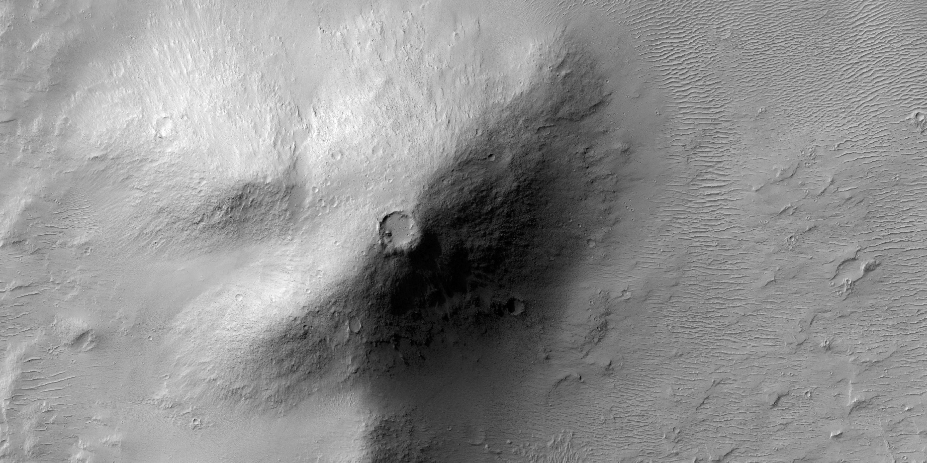
Impact craters are very common on the surface of Mars. However, when a circular depression is visible on the summit of a mound or an elevated landform in general, careful analysis is needed to identify whether the crater is created by an impact or by volcanic activity.

This issue becomes even more problematic when the crater is located in a area known for its volcanic history such as the Apollinaris region where this image was taken and is very close to the prominent volcano Apollinaris Mons.

In fact, this classical problem has been encountered before here on Earth in the case of the famous Meteor Crater in Arizona just outside of the city of Flagstaff. Back in the late 19th century, many people believed that Meteor Crater was a volcanic crater because of its proximity to the San Francisco volcanic field and the rarity of impact craters on Earth.

Meteor Crater remained controversial until the 1960s when scientists were finally able to confirm that the crater was indeed an impact crater by identifying minerals in the crater site that can only form in extremely high pressures, which are usually associated with violent impact events.

In the absence of such “ground truth” or lab analysis, how can planetary scientists differentiate between impact and volcanic craters? There are a number of ways. For example, impact craters usually exhibit raised rims and distinctive ejecta patterns around the crater, formed by materials ejected during the impact event. Large craters (more than 7 kilometers-wide in general for Mars) exhibit central peaks that form due the rebound of the ground right after impact. All these features are not usually observed in volcanic craters. In this observation, none of these features is visible. Nonetheless, this region is old and heavily dusted so all the above-mentioned features may have been eroded away or are covered by other materials.

However, we can see in this image that the crater is on the summit of a mountain- or hill-like elevated land form. In addition, some of the materials at the base of this elevated land form exhibit a rough texture that may resemble volcanic flows. If we add to that that the region is within a volcanic area, it becomes highly likely that this crater in particular is, in fact a volcanic crater.

Photo credit: NASA/JPL/University of Arizona

Thursday, April 3, 2014

Layering in Planum Boreum


With summer fast approaching, the frost has sublimated away and the layers that make up the north polar cap are easily discernible.

Orbit Number: 53890 Latitude: 82.8252 Longitude: 98.7289 Instrument: VIS Captured: 2014-02-06 04:10

Photo credit: NASA/JPL-Caltech/Arizona State University

Wednesday, April 2, 2014

Channel in Arabia Terra


Today's VIS image shows an unnamed channel that dissects the rim of a large crater in Arabia Terra.

Orbit Number: 53879 Latitude: 31.2164 Longitude: 26.7961 Instrument: VIS Captured: 2014-02-05 06:44

Photo credit: NASA/JPL-Caltech/Arizona State University

Tuesday, April 1, 2014

Dust Devil Tracks in Utopia Planitia


A multitude of dust devil tracks mark the surface in this region of Utopia Planitia.

Orbit Number: 53877 Latitude: 55.7328 Longitude: 89.2858 Instrument: VIS Captured: 2014-02-05 02:39

Photo credit: NASA/JPL-Caltech/Arizona State University

Opportunity's Shadow


NASA's Mars Exploration Rover Opportunity caught its own silhouette in this late-afternoon image taken by the rover's rear hazard avoidance camera. This camera is mounted low on the rover and has a wide-angle lens.

The image was taken looking eastward shortly before sunset on the 3,609th Martian day, or sol, of Opportunity's work on Mars (March 20, 2014). The rover's shadow falls across a slope called the McClure-Beverlin Escarpment on the western rim of Endeavour Crater, where Opportunity is investigating rock layers for evidence about ancient environments. The scene includes a glimpse into the distance across the 14-mile-wide (22-kilometer-wide) crater.

Photo credit: NASA/JPL-Caltech

Note: For more information, see Cleaner NASA Rover Sees Its Shadow in Martian Spring.