Thursday, August 9, 2012

Martian Dust Storm Over Utopia Planitia


This close-up image of a dust storm on Mars was acquired by the Mars Color Imager instrument on NASA's Mars Reconnaissance Orbiter on November 7, 2007, around 3 p.m. local time on Mars. Scientists working with NASA's Curiosity rover, which is set to land on Mars on Aug. 5 PDT (August 6 EDT), are monitoring Mars each day for similar small storms that could either drift over the landing site or stir up dust that moves as haze over the site.

This image is centered on Utopia Planitia (53.6 degrees north latitude, 147.9 degrees east longitude), along the north seasonal polar cap edge in late northern winter. When NASA's Curiosity rover lands on Mars, it will be late southern winter. Scientists are looking at similar small storms that form near the south seasonal polar cap edge. The dust storm pictured here was short-lived, lasting less than 24 hours. The image also shows the seasonal north polar cap (at top of figure) and gravity-wave water ice clouds coming off of Mie crater, just south of the storm. Gravity-wave clouds, also called lee-wave clouds, are clouds that result from changes in atmospheric pressure, temperature and height because of vertical displacement, such as when wind blows over a mountain or crater wall.

The projection of the image is polar stereographic and the image has a resolution of about 0.6 miles (1 kilometer) per pixel. North is indicated with an arrow in this image. The white scale bar is 93 miles (150 kilometers).

Photo credit: NASA/JPL-Caltech/MSSS

Note: Obviously the text for this photo was written prior to Curiosity's landing; however, due to the deluge of new photos coming in, I decided to push this blog post back to give priority to some of the other, more important stories.

Wednesday, August 8, 2012

Curiosity's Landing Site


The four main pieces of hardware that arrived on Mars with NASA's Curiosity rover were spotted by NASA's Mars Reconnaissance Orbiter (MRO). The High-Resolution Imaging Science Experiment (HiRISE) camera captured this image about 24 hours after landing. The large, reduced-scale image points out the strewn hardware: the heat shield was the first piece to hit the ground, followed by the back shell attached to the parachute, then the rover itself touched down, and finally, after cables were cut, the sky crane flew away to the northwest and crashed. Relatively dark areas in all four spots are from disturbances of the bright dust on Mars, revealing the darker material below the surface dust.

Around the rover, this disturbance was from the sky crane thrusters, and forms a bilaterally symmetrical pattern. The darkened radial jets from the sky crane are downrange from the point of oblique impact, much like the oblique impacts of asteroids. In fact, they make an arrow pointing to Curiosity.

This image was acquired from a special 41-degree roll of MRO, larger than the normal 30-degree limit. It rolled towards the west and towards the sun, which increases visible scattering by atmospheric dust as well as the amount of atmosphere the orbiter has to look through, thereby reducing the contrast of surface features. Future images will show the hardware in greater detail. Our view is tilted about 45 degrees from the surface (more than the 41-degree roll due to planetary curvature), like a view out of an airplane window. Tilt the images 90 degrees clockwise to see the surface better from this perspective. The views are primarily of the shadowed side of the rover and other objects.

The Curiosity rover is approximately 4,900 feet (1,500 meters) away from the heat shield; about 2,020 feet (615 meters) away from the parachute and back shell; and approximately 2,100 feet (650 meters) away from the discoloration consistent with the impact of the sky crane.

The image scale is 39 centimeters (15.3 inches) per pixel.

Photo credit: NASA/JPL-Caltech/University of Arizona

Note: For more information, see Orbiter Images NASA's Martian Landscape Additions.

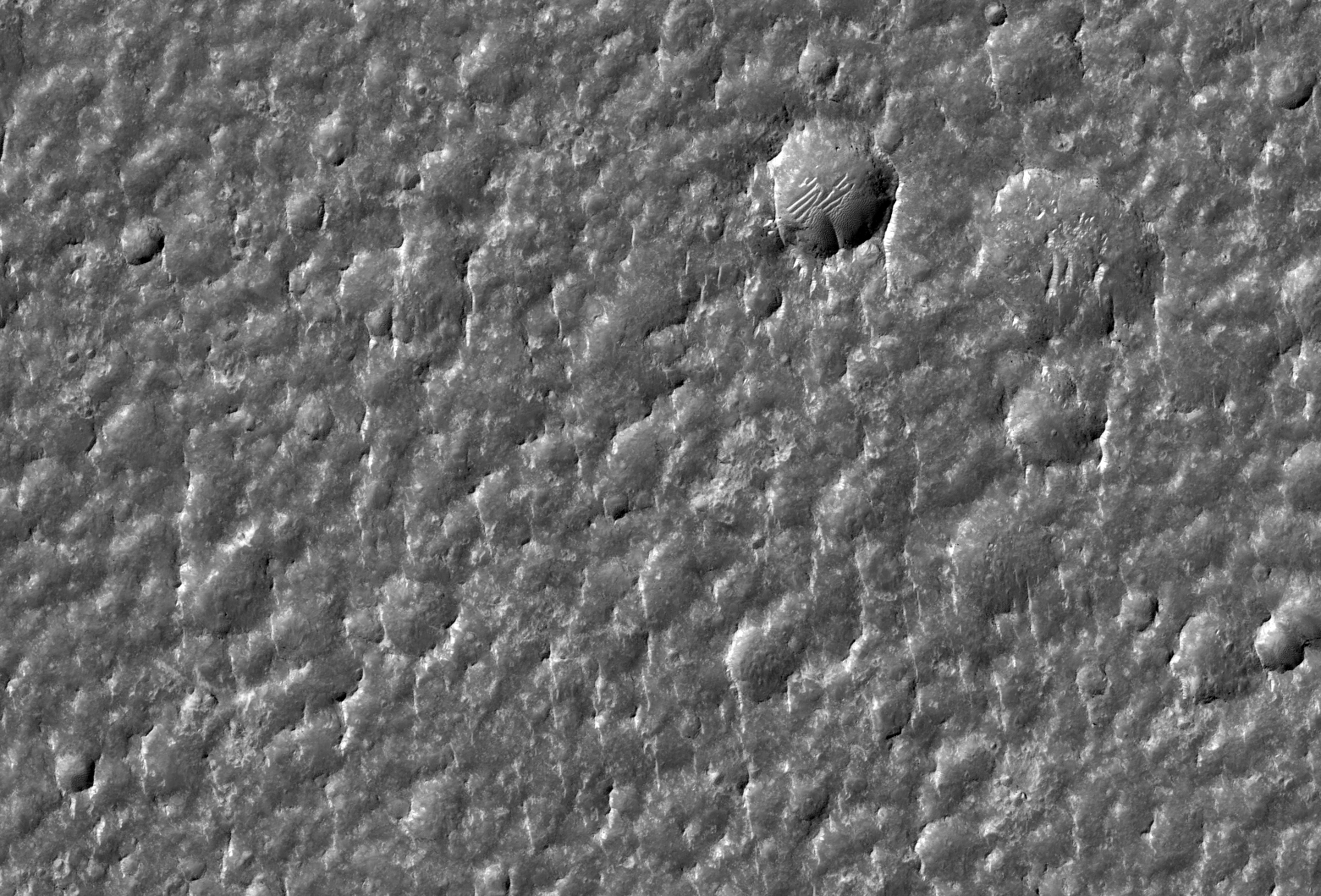
Fresh Impact Crater North of Coprates Chasma


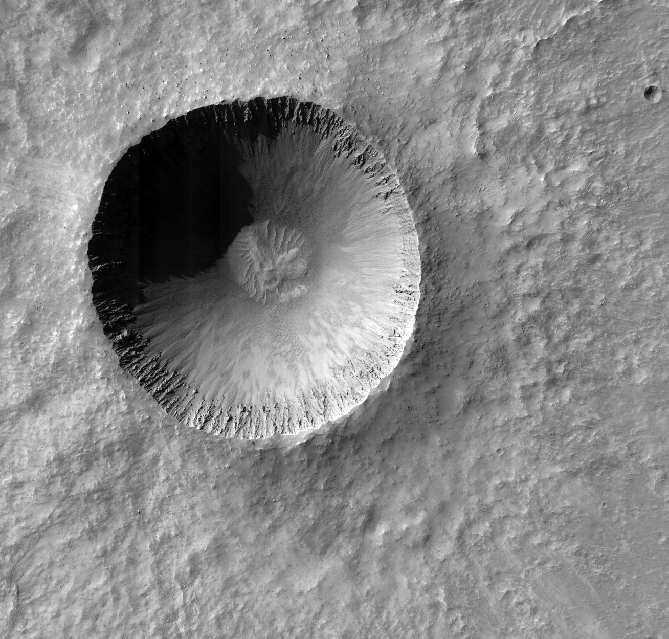
This image shows a fresh impact crater about 2 kilometer (1.2 miles) across. How do we know it is fresh?

The crater walls are steep and rocky, and fine striated texture is still visible on the ejecta. Over time, erosion and dust settling out of the atmosphere will smooth out such details. However, these processes are slow on Mars, and the crater is probably at least several million years old.

Craters like this are important targets for HiRISE for several reasons. The details of the fresh crater are interesting in themselves for studying impact processes, but crater walls can also provide great exposures of bedrock. The steep slopes are also good places to look for active processes like rockfalls happening today, especially when we can compare a series of images taken over several years.

Photo credit: NASA/JPL/University of Arizona

Tuesday, August 7, 2012

Curiosity Descending Into Gale Crater


NASA's Curiosity rover and its parachute were spotted by NASA's Mars Reconnaissance Orbiter as Curiosity descended to the surface on August 5 PDT (August 6 EDT). The High-Resolution Imaging Science Experiment (HiRISE) camera captured this image of Curiosity while the orbiter was listening to transmissions from the rover. Curiosity and its parachute are in the center of the white box; the inset image is a cutout of the rover stretched to avoid saturation. The rover is descending toward the etched plains just north of the sand dunes that fringe "Mt. Sharp." From the perspective of the orbiter, the parachute and Curiosity are flying at an angle relative to the surface, so the landing site does not appear directly below the rover.

The parachute appears fully inflated and performing perfectly. Details in the parachute, such as the band gap at the edges and the central hole, are clearly seen. The cords connecting the parachute to the back shell cannot be seen, although they were seen in the image of NASA's Phoenix lander descending, perhaps due to the difference in lighting angles. The bright spot on the back shell containing Curiosity might be a specular reflection off of a shiny area. Curiosity was released from the back shell sometime after this image was acquired.

This view is one product from an observation made by HiRISE targeted to the expected location of Curiosity about one minute prior to landing. It was captured in HiRISE CCD RED1, near the eastern edge of the swath width (there is a RED0 at the very edge). This means that the rover was a bit further east or downrange than predicted.

The image scale is 13.2 inches (33.6 centimeters) per pixel.

Photo credit: NASA/JPL-Caltech/Univ. of Arizona

Note: For more information, see NASA's Curiosity Rover Caught in the Act of Landing; also, NASA's Curiosity Rover Caught in the Act of Landing (same title, different page).

Ladon Valles


High-Resolution Stereo Camera (HRSC) nadir and colour channel data taken during revolution 10602 on 27 April 2012 by ESA’s Mars Express have been combined to form a natural-color view of the Ladon Valles region. Centered at around 18°S and 329°E, this image has a ground resolution of about 20 m per pixel. The image shows the interconnected craters Sigli and Shambe, believed to have formed when a large meteorite fragmented in to two pieces just before impact. Extensive fracturing can be seen within the craters. Above the craters (west), creek-like flow channels can be seen leading in to the wider impact basin region to the right (north).

Photo credit: ESA/DLR/FU Berlin (G. Neukum)

Monday, August 6, 2012

First Images from Curiosity


This image shows one of the first views from NASA's Curiosity rover, which landed on Mars the evening of August 5 PDT (early morning hours August 6 EDT). It was taken through a "fisheye" wide-angle lens on one of the rover's Hazard-Avoidance cameras. These engineering cameras are located at the rover's base. As planned, the early images are lower resolution. Larger color images are expected later in the week when the rover's mast, carrying high-resolution cameras, is deployed.

Photo credit: NASA/JPL-Caltech


This is one of the first images taken by NASA's Curiosity rover, which landed on Mars the evening of August 5 PDT (morning of August 6 EDT). It was taken through a "fisheye" wide-angle lens on the left "eye" of a stereo pair of Hazard-Avoidance cameras on the left-rear side of the rover. The image is one-half of full resolution. The clear dust cover that protected the camera during landing has been sprung open. Part of the spring that released the dust cover can be seen at the bottom right, near the rover's wheel.

On the top left, part of the rover's power supply is visible.

Some dust appears on the lens even with the dust cover off.

The cameras are looking directly into the sun, so the top of the image is saturated. Looking straight into the sun does not harm the cameras. The lines across the top are an artifact called "blooming" that occurs in the camera's detector because of the saturation.

As planned, the rover's early engineering images are lower resolution. Larger color images from other cameras are expected later in the week when the rover's mast, carrying high-resolution cameras, is deployed.

Photo credit: NASA/JPL-Caltech

Notes: For more information on the lower photo see NASA's New Mars Rover Sends Higher-Resolution Image. Are these blueberries in the sand?

Cloudy with a chance of...


This global map of Mars was acquired on August 2, 2012, by the Mars Color Imager instrument on NASA's Mars Reconnaissance Orbiter. One global map is generated each day to forecast weather conditions for the entry, descent and landing of NASA's Curiosity rover. The active dust storm observed south of Curiosity's landing site on July 31 has dissipated, leaving behind a dust cloud that will not pose a threat to the landing.

The map is a rectangular projection of Mars (from 90 degrees latitude to minus 90 degrees latitude, and minus 180 degrees longitude to 180 degrees east longitude). The landing site is located on the right side of the map, near 137 degrees east longitude and 4.5 degrees south latitude. The map shows water ice clouds at equatorial latitudes that are typical for late southern winter, when Mars is farther from the sun. Along the southern (bottom) part of the map there are patches of orange clouds, indicating dust lofted into the atmosphere. Small, short-lived dust storms are common at this time of year on Mars and were taken into account when Curiosity's landing system was designed and tested. Larger and more long-lived dust storms are very rare at this time of year.


This global map of Mars was acquired on October 28, 2008, by the Mars Color Imager instrument on NASA's Mars Reconnaissance Orbiter. It was acquired during the same season that NASA's Curiosity rover will land in, but two Mars years earlier. It is remarkably free of water ice clouds when compared with the maps acquired this year in the days leading up to Curiosity's landing.

In 2008, during this season, the planet was dustier than usual. Larger amounts of dust cause sunlight to warm the atmosphere and make it less dense, which means less stopping power for a landing rover. What's more, dusty conditions can lead to an increased chance for small, intense dust storms, another challenge for rover landings. So far, the weather forecast for Curiosity calls for a clearer atmosphere; nonetheless, the spacecraft has been designed to land safely under conditions similar to those observed in 2008.

The map is a rectangular projection of Mars (from 90 degrees latitude to minus 90 degrees latitude, and minus 180 degrees longitude to 180 degrees east longitude). The landing site is located on the right side of the map, near 137 degrees east longitude and 4.5 degrees south latitude. Along the northern (top) and southern (bottom) parts of the map there are patches of orange clouds, indicating dust lofted into the atmosphere.

Map credit 1: NASA/JPL-Caltech/MSSS; map credit 2: NASA/JPL-Caltech/MSSS

Note: NASA has released an additional Martian weather map, that of August 5th, the day Curiosity landed in Gale Crater.

Sunday, August 5, 2012

Nested Craters in Utopia Planitia


Impact craters that are only a few kilometers in size on Mars usually have simple bowl shaped interiors with craters in weaker material being larger than craters in stronger material.

Occasionally though, nature is more complicated and these simple rules don't apply. One such case is shown here where is appears as if there are craters nested within each other. These nested craters are probably caused by changes in the strength of the target material. This usually happens when a weaker material overlies a stronger material.

We can use craters like this to tell us something about what lies below the surface. What could be causing the change in strength in the subsurface? Mars has a lot of ice in its terrain near the surface. This ice-rich layer could be the weaker material and the deeper ice-free layer could be the stronger material.

Photo credit: NASA/JPL/University of Arizona

Saturday, August 4, 2012

Regional Topography Map Around Gale Crater


Gale Crater on Mars, where NASA's Curiosity rover is set to land, belongs to a family of large, very old craters shown here on this elevation map. It has one of the lowest elevations among this family.

The data come from the Mars Orbiter Laser Altimeter instrument on NASA's Mars Global Surveyor.

Map credit: NASA/JPL-Caltech

Layers in Flammarion Crater


The objective of this observation is to examine layers. In and around this region, there are outcrops of layered terrain.

A high resolution image can see minute details that will enable us to start to catalog different types of layers and to discover under what conditions they are produced. In this particular image there is a cap rock on top of some poorly formed layers and some well formed layers.

Photo credit: NASA/JPL/University of Arizona

Friday, August 3, 2012

Magnetic Fields of Earth and Mars


This is an artist's concept comparing the present day magnetic fields on Earth and Mars. Earth's magnetic field is generated by an active dynamo -- a hot core of molten metal. The magnetic field surrounds Earth and is considered global (left image). The various Martian magnetic fields do not encompass the entire planet and are local (right image). The Martian dynamo is extinct, and its magnetic fields are "fossil" remnants of its ancient, global magnetic field.

Image credit: NASA/GSFC

Dunes on the Move in Lyot Crater


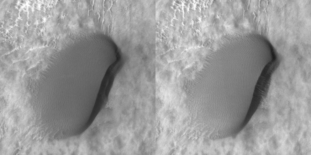
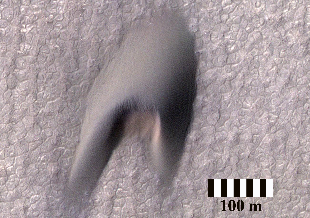
HiRISE has been carrying out a dedicated survey of sand dunes on Mars, determining whether and how fast the dunes move by observing repeatedly at intervals of Martian years. More than 60 sites have been monitored so far, showing that sand dunes from the equator to the poles are advancing at rates of up to 1 meter per Martian year.

These observations are still spotty, however, and tend to be concentrated in the tropics and the North Polar erg (the sand sea that surrounds the North Pole). One latitude band that had not been sampled at all lies between 30 and 65 degrees north. This observation is among a set of images acquired to fill that gap.

This image shows a variety of different dune types in southern Lyot Crater in the northern lowlands at 48.9 degrees North. Transverse dunes to the west grade into longitudinal dunes downwind to the east and barchans to the south, possibly because of local winds channeled by topography in the impact basin. This image was intended to match the approximate illumination and viewing conditions of an earlier HiRISE observation that was made two Martian years earlier, in August 2008.

Detailed comparison of the two images shows movement on many of the dunes during this interval of nearly four Earth years. The subimage is an animation showing changes on one of the small barchans in the south of the dune field. The area pictured in the subimage is about 100 meters across. Winds from the west (left) have shifted the small ripples up the back of the dune towards the east. Sand has blown over the crest of the dune, cascaded down the steep slip face, and accumulated along the base of the slip face in the lee of the dune. In this way, the small dune advances slowly downwind.

Other images also show dune activity in this latitude band, adding to a growing suspicion that dunes are on the move everywhere on Mars, faster in some places than others.

Photo credit: NASA/JPL/University of Arizona

Wednesday, July 25, 2012

Tyrrhena Terra


The 1000 × 2000 km area region of Tyrrhena Terra (outlined by the white box in the inset) sits between two regions of low altitude – Hellas Planitia and Isidis Planitia – in Mars' southern hemisphere, as shown in this global topography map. Hydrated minerals were found in 175 locations associated with impact craters in Tyrrhena Terra, such as inside the walls of craters, along crater rims, or in material excavated by the impact. Analysis suggests that these minerals were formed in the presence of water that persisted at depth for an extended period of time.

Map credit: NASA/MOLA Science Team/D. Loizeau et al.

Sunday, July 22, 2012

Streaks on the North Polar Layered Deposits


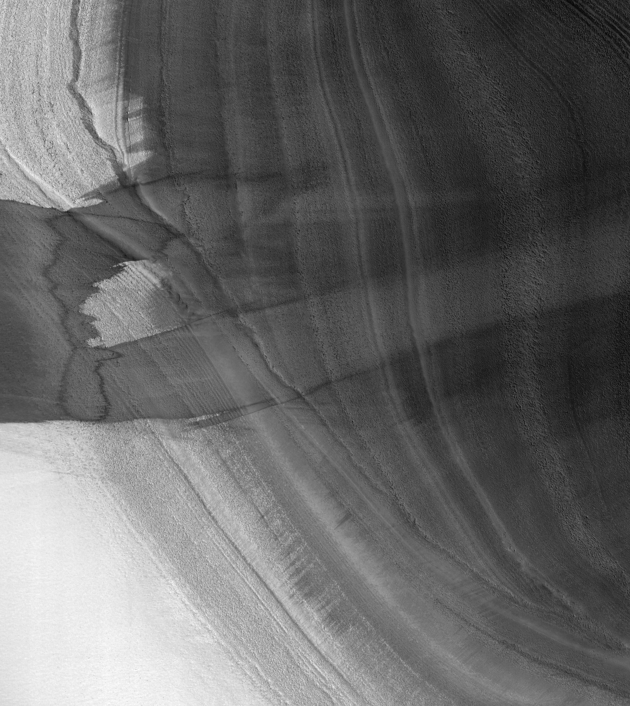
This image shows an exposure of the north polar layered deposits with strange streaks superimposed on the layers.

These streaks may be formed by winds blowing bright water frost over the surface, removing frost from the surface, or blowing dark material over the frost. These streaks make it a bit more difficult to see the angular unconformity running from upper left to lower right. The unconformity can be traced by finding where the layers at the top of the image are truncated by the layers at the bottom of the image.

This relationship shows that the layered deposits were eroded in this area, probably thousands to millions of years ago, before younger layers were deposited over them. The streaks over them were formed during the current northern summer, and may not persist for long.

Photo credit: NASA/JPL/University of Arizona

Saturday, July 21, 2012

Active Sand Abrasion in the Northern Polar Region of Mars


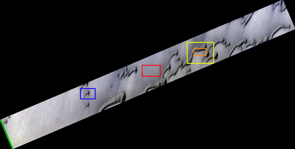
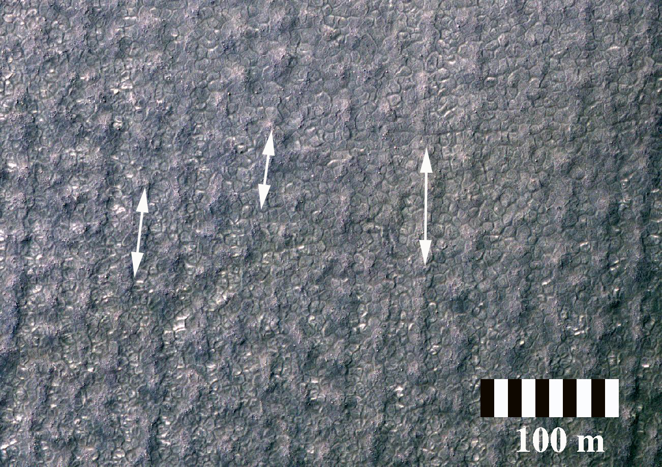
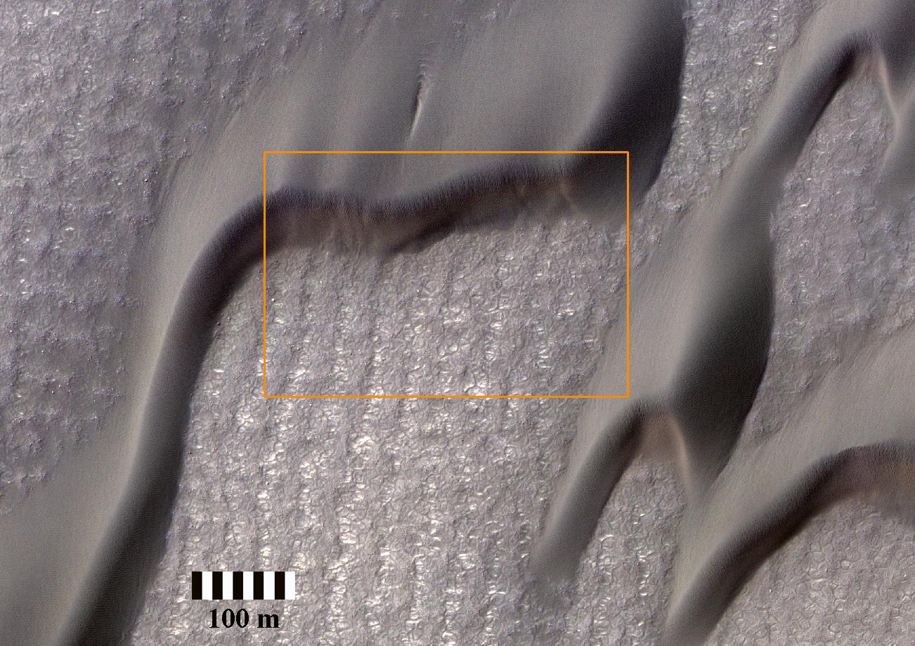
The large dune field which surrounds Mars' North Polar cap is actively being modified by the wind, with dunes moving at rates of a meter or more per year (PDF). This new HiRISE image shows that the blowing sand is also abrading the ice-rich ground over which the dunes migrate.

Clearly visible in the black and white and color HiRISE frames is a linear texture on the interdune surface that is oriented north-northeast to south-southwest. This orientation matches that of the horns and slipfaces of the barchan dunes, which together indicate migration from the north-northeast to the south-southwest. Visible here are four zoomed views that provide details of this texture. Zoom A/blue box shows a typical barchan dune. The linear texture is visible, albeit subtly, on the surrounding ground surface.

The texture is more apparent in the next views: A zoom of an interdune surface (Zoom B/red box) shows the wind-etched topography as a series topographic high and lows, with the directional trend indicated by the white arrows. This is also clearly seen next to another dune (Zoom C/yellow box). Further zooming in shows that the topographic highs contain boulders, which may be ice rich (Zoom D/orange box). Most of the sand abrasion probably occurs within the topographic troughs, accentuating topography and abrading away boulders, leaving remnant rocks on the highs. This shows that sand abrasion is actively modifying the surface in Mars' northern latitudes.

This is a stereo pair with ESP_027248_2550.

Photo credit: NASA/JPL/University of Arizona

Friday, July 20, 2012

Layered Material Cut by a Valley Connected to East Jezero Crater


This image shows layered bedrock composed of light- and intermediate-toned materials. There are also darker bed forms that fill in low-lying topography, such as impact craters.

In the center of the image is a valley with darker fill extending from left to right. The darker materials within the valley might be fluvial sediments. At HiRISE resolution, we might be able to decipher the properties of the bedrock as well as what deposited the sediments.

Photo credit: NASA/JPL/University of Arizona

Thursday, July 19, 2012

Wavy-Looking Layers in the North Polar Layered Deposits


These layers near the North Pole of Mars probably record global climate changes, similar to ice ages on Earth.

They appear wavy here either because flat-lying layers have been eroded into shallow valleys and ridges, or because the layers are not horizontal. Some of these layers are truncated, or appear to pinch out against other layers, evidence of a period of erosion followed by continued deposition of new layers.

The orientations of both the wavy-looking layers and the "unconformity" or erosional surface will be determined once this image and its stereo pair have been used to measure the surface topography.

This is a stereo pair with ESP_026662_2625.

Photo credit: NASA/JPL/University of Arizona

Note: This image is located in the Gemini Scopuli region of Planum Boreum; the closest named feature to this location is Udzha Crater, to the southeast.

Wednesday, July 18, 2012

Flows in Hellas Planitia


Hellas Planitia is the interior of the Hellas impact basin, is one of the largest visible impact craters in the Solar System. Hellas is located in the Southern highlands and formed very early in the planet's history. The floor of Hellas includes the lowest elevations on Mars and some of the strangest landscapes.

The most striking feature of this observation are the incredible banded features, probably due to the flow of surface material. Although Martian flow features may have Earth analogs such as rock glaciers, it's uncertain as to what types of fluvial, glacial and mass-wasting processes are involved in their formation.

This is a stereo pair with ESP_017644_1420.

Photo credit: NASA/JPL/University of Arizona

Tuesday, July 17, 2012

Geological Diversity at Curiosity's Landing Site


The area where NASA's Curiosity rover will land on August 5 PDT (August 6 EDT) has a geological diversity that scientists are eager to investigate, as seen in this false-color map based on data from NASA's Mars Odyssey orbiter. The image was obtained by Odyssey's Thermal Emission Imaging System. It merges topographical data with thermal inertia data that record the ability of the surface to hold onto heat.

The yellow oval shows the elliptical landing target for Curiosity's landing site.

An alluvial fan is visible around a crater to the northwest of the landing area. A series of undulating lines traveling southeast from the crater indicates similar material moving down a slope. The material, which appears bluish-green in this image, also forms a fan shape.

An area in red indicates a surface material that is more tightly cemented together than rocks around it and likely has a high concentration of minerals. An attractive interpretation for this texture is that water could have been present there some time in the past.

Curiosity is expected to land within the large Gale Crater. The rim of a smaller crater (about a half mile, or 1 kilometer, in diameter) inside of Gale is visible at the bottom right of the image.

Map credit: NASA/JPL-Caltech/Arizona State University

Note: For more information, see NASA's Car-Sized Rover Nears Daring Landing on Mars

Monday, July 16, 2012

Gully Monitoring on Crater Slopes in Terra Sirenum


These crater gullies lie on the northern wall of an unnamed 9-kilometer diameter southern hemisphere crater in Terra Sirenum. The image was acquired during early winter in the southern hemisphere, so the crater wall is in shadow.

These gullies were first imaged by HiRISE in 2006. Since that time the possible role of seasonal frost in gully formation along with the association of polygonal terrain with these and other gullies has garnered considerable interest. As a result, these gullies have become one of several locations being monitored by HiRISE throughout multiple Mars years. Over a dozen images of these gullies have been acquired to date throughout different Mars seasons.

In this image, frost (likely water-ice) is once again forming on these southern hemisphere mid-latitude crater slopes. The subimage shows gullies on the shadowed polar-facing slope. The large dynamic range of the HiRISE camera allows one to see into the shadows dimly lit by sunlight scattered by the surface and the atmosphere. These gullies are thinly veiled with frost and range in width from several meters to tens of meters and in length from a couple kilometers or so. Dark regions within the gullies are warmer areas where frost likely evaporated or melted exposing the darker underlying surface.

Photo credit: NASA/JPL/University of Arizona

Sunday, July 15, 2012

Frosted Gullies in Newton Crater


This image shows a crater wall in the southern hemisphere, with gully landforms.

Gullies like these are mostly found in the mid-latitudes, between 30-50 degrees north or south. In the Martian winter, frost (mostly carbon dioxide) can build up in the gullies, especially on the cold slopes that face the pole.

The bright, bluish (enhanced-color) frost can be clearly seen in the upper alcoves of gullies here. We now know that Martian gullies are active, and that most changes occur in the winter--it is likely that frost like this causes the activity in some way.

Photo credit: NASA/JPL/University of Arizona

Note: This landscape is located on the eastern wall of Newton Crater. The Mars 3 landing site is located to the southwest of this location.

Saturday, July 14, 2012

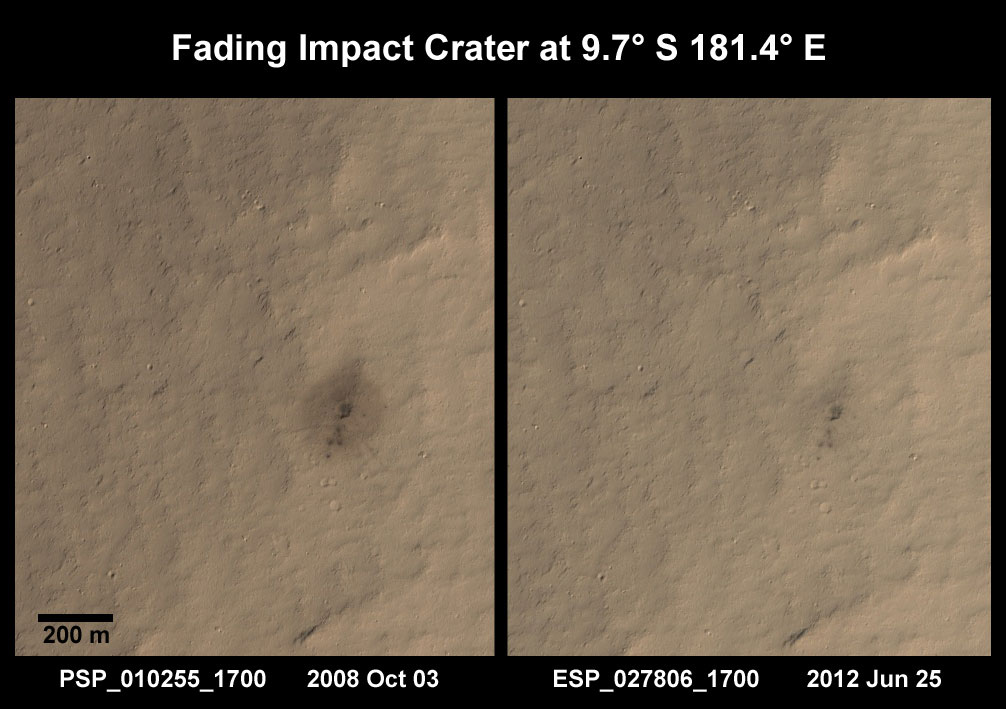
A Fading Impact Crater in Lucus Planum


This cluster of craters formed quite recently from a weak impactor that broke apart in Mars' thin atmosphere before smashing into the surface. It was discovered by the MRO Context Camera (CTX) Team, who found a dark spot in a CTX image taken in August 2008 that was not present in earlier Mars Odyssey Mission THEMIS images from July 2005. HiRISE examined the feature in October 2008 and verified that the dark spot was impact ejecta excavated from beneath the bright surface.

On June 25 2012, HiRISE took another look at the young crater to see how it had fared after two Martian years. This image was timed to closely match the illumination and viewing conditions of the earlier HiRISE image. A comparison of the two images shows that the dark halo surrounding the crater cluster has nearly vanished. The delicate rays extending beyond the halo are also significantly faded. Only the individual craters remain distinctly dark in the new image.

This observation is important for two reasons. First, it raises questions about the Martian winds and sediments that produce such changes. Did the dark ejecta blow away, or was it buried by a layer of bright dust? Second, it tells us that the window for detection of these young craters can be very short. In this case, the dark spot that drew the attention of the Context Camera Team was the 200-meter diameter halo of ejecta that encircled the crater cluster. After two Martian years, the halo is gone and the impact cluster would not be easily detected.

Photo credit: NASA/JPL/University of Arizona

Note: This feature is located in Lucus Planum to the west of Memnonia Sulci.

Friday, July 13, 2012

Ridges in Meridiani Planum


When terrain gets squeezed by geologic forces, deep rocks sometimes break and get pushed upwards forming raised wrinkles on the surface. These wrinkle ridges are common on a lot of planets including Mars.

One of these ridges exists south of this image but seems to have been buried there. With HiRISE, we might be able to figure out the sequence of events by comparing the topography of the ridge with the younger layer that buries it.

Meridiani Planum is famous for another reason. This is where the rover Opportunity landed and has been exploring since 2004.

This is a stereo pair with ESP_025663_1800.

Photo credit: NASA/JPL/University of Arizona

Thursday, July 12, 2012

Antoniadi Crater


Some of of the challenges of exploring Mars is not only finding a safe landing spot for a future rover, but a place that is scientifically compelling as well.

HiRISE has taken scores of observations for other missions like Phoenix and the Mars Science Laboratory to help those science teams better understand possible terrain hazards. In this observation, we are trying to explore for the presence of minerals called quartz and feldspar, which are even more common on Earth than Mars.

Antoniadi Crater was identified, even prior to the MRO mission, as a likely ancient lake (now dry) that was supplied by both surface water and ground water. Note also how "flat" the terrain appears, an important factor for any potential landing spot.

Photo credit: NASA/JPL/University of Arizona

Wednesday, July 11, 2012

Rough Surfaces in Deuteronilus Mensae


The objective of this observation is to examine what may be formerly ice-rich terrain that has just lost ice to the atmosphere.

Research with the Shallow Radar instrument onboard the Mars Reconnaissance Orbiter has found that many areas in Deuteronilus Mensae are glaciers with a thin layer of debris on top of them. This image may show a transition from ice-rich to ice-poor terrain.

Removal of buried ice can cause collapse and may be responsible for the strange appearance of this terrain. Understanding the origin of features in this image tells us something about when buried ice was stable or unstable and therefore helps us figure out how the climate of Mars has changed.

Photo credit: NASA/JPL/University of Arizona

Tuesday, July 10, 2012

Colorful Layers in Nili Fossae


This enhanced-color version of the central part of the HiRISE image shows colorful layers that may contain carbonate minerals.

Carbonates are commonly formed on Earth by marine organisms; the origin of these carbonates on Mars is unknown, but probably involved liquid water.

This image was taken along with the CRISM instrument, also onboard MRO, in what is called "ridealong" mode.

Photo credit: NASA/JPL/University of Arizona

Notes: This picture was taken in the Nili Fossae area to the northeast of Hargraves Crater. For the Spanish translation of this page, see Estratos de Colores en Nili Fossae.

Monday, July 9, 2012

Sinuous Ridges in Aeolis Planum


In this image, we see several very sinuous ridges, some very eroded, and others still very well defined.

The eroded ridges are located in a trough, while the well-preserved ridges are at higher elevation. The image allows scientists to characterize the morphology and the local texture of both type of ridges and determine whether those where part of the same network or where formed at two different stratigraphic levels, during different fluvial episodes.

This is a stereo pair with ESP_026818_1740.

Photo credit: NASA/JPL/University of Arizona

Sunday, July 8, 2012

Two Craters in Terra Sabaea: Which Came First?


This image shows two craters, both approximately the same diameter (not quite 3 kilometers, or about 1.8 miles), but quite different in appearance otherwise.

The slightly smaller crater to the south seems to have a sharper rim and steeper sides than its partner to the north, which also appears to contain more small craters inside it and along its rim. The interior of the northern crater, in particular its south-facing wall, appears to have a similar texture to the ejecta around the southern crater. This is the second image in a stereo pair (the first is ESP_019346_1690), so we have an anaglyph of these craters.

Although it would require a digital terrain model and more analysis to be certain, in the anaglyph it appears that the southern crater has a higher rim and a deeper center than the northern crater. All these signs point to the northern crater being quite a bit older than the southern crater, rather than the two craters forming in the same impact event. For an example of two craters that might have formed at the same time (see ESP_020894_1395).

Compare the similarity of those two craters with the disparate appearance of the ones in this image.

This is a stereo pair with ESP_019346_1690.

Photo credit: NASA/JPL/University of Arizona

Note: This image is located in southwestern Terra Sabaea, near the Noachis Terra border. The closest named feature is Pollack Crater, which is a short distance to the north.

Saturday, July 7, 2012

Greeley Haven Panorama


This full-circle scene combines 817 images taken by the panoramic camera (Pancam) on NASA's Mars Exploration Rover Opportunity. It shows the terrain that surrounded the rover while it was stationary for four months of work during its most recent Martian winter.

Opportunity's Pancam took the component images between the 2,811th Martian day, or sol, of the rover's Mars surface mission (December 21, 2011) and Sol 2,947 (May 8, 2012). Opportunity spent those months on a northward sloped outcrop, "Greeley Haven," which angled the rover's solar panels toward the sun low in the northern sky during southern hemisphere winter. The outcrop's informal name is a tribute to Ronald Greeley (1939-2011), who was a member of the mission team and who taught generations of planetary scientists at Arizona State University, Tempe. The site is near the northern tip of the "Cape York" segment of the western rim of Endeavour Crater.

North is at the center of the image. South is at both ends. On the far left at the horizon is "Rich Morris Hill." That outcrop on Cape York was informally named in memory of John R. "Rich" Morris (1973-2011), an aerospace engineer and musician who was a Mars rover team member and mission manager at NASA's Jet Propulsion Laboratory, Pasadena.

Bright wind-blown deposits on the left are banked up against the Greeley Haven outcrop. Opportunity's tracks can be seen extending from the south, with a turn-in-place and other maneuvers evident from activities to position the rover at Greeley Haven. The tracks in some locations have exposed darker underlying soils by disturbing a thin, bright dust cover.

Other bright, dusty deposits can be seen to the north, northeast, and east of Greeley Haven. The deposit at the center of the image, due north from the rover's winter location, is a dusty patch called "North Pole." Opportunity drove to it and investigated it in May 2012 as an example of wind-blown Martian dust.

The interior of Endeavour Crater can been seen just below the horizon in the right half of the scene, to the northeast and east of Cape York. The crater spans 14 miles (22 kilometers) in diameter.

Opportunity's solar panels and other structures show dust that has accumulated over the lifetime of the mission. Opportunity has been working on Mars since January 2004.

During the recent four months that Opportunity worked at Greeley Haven, activities included radio-science observations to better understand Martian spin axis dynamics and thus interior structure, investigations of the composition and textures of an outcrop exposing an impact-jumbled rock formation on the crater rim, monitoring the atmosphere and surface for changes, and acquisition of this full-color mosaic of the surroundings.

The panorama combines exposures taken through Pancam filters centered on wavelengths of 753 nanometers (near infrared), 535 nanometers (green) and 432 nanometers (violet). The view is presented in false color to make some differences between materials easier to see.

Photo credit: NASA/JPL-Caltech/Cornell/Arizona State University

Note: For more information, see Mars Panorama: Next Best Thing to Being There.

Friday, July 6, 2012

Melas Dorsa


High-Resolution Stereo Camera (HRSC) nadir and color channel data taken during revolution 10532 on 17 April 2012 by ESA’s Mars Express have been combined to form a natural-color view of the Melas Dorsa region. Centered at around 18°S and 288°E, this image has a ground resolution of about 18 m per pixel. The image shows the wrinkle ridges bisected by crustal displacement faults known as ‘en-echelon’ faults along with the large impact crater with its butterfly-shaped fluidized ejecta blanket. En-echelon faults are closely spaced, parallel overlapping or step-like fault structures, which in this view can be seen at the far left of the image, intersecting the wrinkle ridges.

Photo credit: ESA/DLR/FU Berlin (G. Neukum)

Thursday, June 28, 2012

Excavating Water-Rich Rocks


The large 25 km-diameter crater in the foreground of this High Resolution Stereo Camera (HRSC) perspective view has excavated rocks which have been altered by groundwater in the crust before the impact occurred. Using OMEGA (Visible and Infrared Mineralogical Mapping Spectrometer) on ESA's Mars Express and CRISM (Compact Reconnaissance Imaging Spectrometer for Mars) on NASA's Mars Reconnaissance Orbiter (MRO), scientists have identified hydrated minerals in the central mound of the crater, on the crater walls and on the large ejecta blanket around the crater. Hydrated minerals were found in 175 locations associated with other nearby craters in the Tyrrhena Terra region of Mars.

Photo credit: Mars Express HRSC, ESA/DLR/FU Berlin (G. Neukum); NASA/MOLA Science Team; D. Loizeau et al.

Note: For more information, see Craters Expose Action of Groundwater Beneath Martian Highlands.

Monday, June 18, 2012

Bright Material along the Floor of a Trough in Noctis Labyrinthus


Many of the troughs (or, rounded depressions) of Noctis Labyrinthus contain bright, sometimes layered, materials. Noctis Labyrinthus is located on the far western end of the large canyon system Valles Marineris. To the west lie the volcanoes of Tharsis.

This HiRISE image shows an example of the bright material commonly found along the floors of some of the Noctis troughs. Spectral data from the CRISM instrument, also onboard the MRO spacecraft, indicate the bright material is hydrated (i.e., contains water). The hydrated material may have formed when water upwelled into the low-lying depression or when ice within the trough melted due to heating from volcanic activity.

An earlier image taken of this same location will now be combined with this new image to produce a stereo anaglyph. The stereo should allow scientists to understand the relationship between the bright material and the darker rocks that make up the trough floor.

This is a stereo pair with ESP_017399_1680.

Photo credit: NASA/JPL/University of Arizona

Saturday, June 9, 2012

Pluvo Point


This image near Mars' North Pole was a public image suggestion, with the following rationale: "My three year old son has dubbed this white smudge 'Pluvo Point', he thinks 'we should take a picture of it to learn about how snow and ice comes down on Mars.'"

Although we can clearly see the bright area in this image, it isn't due to frost or ice at this time of year (early summer), and doesn't have the relatively blue color expected for frost. So, what does create the "white smudge"?

The image shows a typical region of northern plains covered by polygons and boulders. There are dark areas in low spots that are probably due to windblown dark sand. Where the sand is most abundant, it forms the dunes seen near the top and bottom of this image. The "white smudge" appears to be a region with relatively little dark sand. It isn't actually white, but it is brighter than other nearby regions. These could be low hills where the sand doesn't collect.

Photo credit: NASA/JPL/University of Arizona

Note: This site is located in Vastitas Borealis to the south of Gemini Scopuli; the closest named feature is Inuvik Crater, which is to the north.

Friday, June 8, 2012

Danielson and Kalocsa Craters


High-Resolution Stereo Camera (HRSC) nadir and color channel data taken on 19 June 2011 by ESA’s Mars Express have been combined to form a natural-color view of the Danielson and Kalocsa craters and their environment in the Arabia Terra region. Centered at around 7°N and 353°E, this image has a ground resolution of about 26 m per pixel. The image shows the yardangs bisected by the darker dune field in Danielson Crater.

Photo credit: ESA/DLR/FU Berlin (G. Neukum)

Note: Danielson crater is the impact crater on the right.

Monday, June 4, 2012

Near the Mouth of Morava Valles


Morava Valles drained Ladon Basin and discharged towards the large regions of chaotic terrain near the head of Ares Vallis.

Because the valley emerges full bore from Ladon Basin (much like the Niagara River emerges from Lake Erie on the Earth), it has been hypothesized that it was formed when a lake overflowed the basin.

There are numerous valleys, including the large Ladon Valles, that end along the margin of Ladon Basin. Some of the outcrops visible in this image and elsewhere in the basin show evidence of layering due to deposition of sediments.

Comparison of the nature and extent of layers exposed here and elsewhere around Ladon basin should help to constrain their origin, by water flow or other processes.

Photo credit: NASA/JPL/University of Arizona

Sunday, June 3, 2012

Landforms in Cerberus Fossae


The landforms in this observation are quite diverse, with a segment of the Cerberus Fossae (a deep trough extending east-west) and surrounding terrain that has been eroded by some fluid, either water or lava.

There are many boulders in places, either on steep slopes or excavated by impact craters. The high hills are islands of older terrain surrounded by younger lavas.

Be sure to check out the stereo anaglyph.

This is a stereo pair with ESP_026712_1960.

Photo credit: NASA/JPL/University of Arizona

Note: I have modified this title from "Landforms Near Grjotá Valles" to Landforms in "Cerberus Fossae." Grjotá Valles is some distance off to the east from the location in the above image. This site is actually in the heart of Cerberus Fossae, hence the title change.

Saturday, June 2, 2012

Streamlined Hills in Elysium Planitia


This observation was taken to investigate the topography of hills that were eroded by floods of water or lava. In many locations near here it is clear that the last fluid to flow through the region was lava.

Clear margins of lava flows are visible as well as lava textures on the channel floor. In this location, the cover of wind-blown sand and the effect of many small impact craters has erased such obvious indicators of lava. This is likely because the lava coating is thin and can be easily erased.

However, it is also possible that no lava passed through this location. Further investigation of these data should help us better understand the role of water and lava in changing the Martian landscape.

This is a stereo pair with ESP_025802_1960.

Photo credit: NASA/JPL/University of Arizona

Note: This hill is located in Phlegra Dorsa in the immediate vicinity of Grjotá Valles.

Friday, June 1, 2012

Different Materials Exposed along a Wallrock Slope in Coprates Chasma


This image shows several kilometers of topography exposed along the wallrock within Coprates Chasma. Higher topography is towards the bottom of the image while the floor of Coprates Chasma is visible at the top of the image.

There are patches of brighter materials exposed within the wallrock and along the chasma floor. The bright massive rocks exposed in the wallrock likely represent weathered rocks that have altered to this brighter material.

Lower down the wallrock and along the chasma floor, the brighter material appears layered and could represent sediments deposited within the chasma when water or ice may have existed here. The image also shows finer material composed of eroded wallrock and aeolian debris that is mass wasting downslope.

Photo credit: NASA/JPL/University of Arizona

Note: This image is located in far eastern Coprates Chasma, near the entrance of Capri Chasma. The closest named feature is Saravan Crater, to the south.

Thursday, May 31, 2012

Sand Ripples West of Aeolis Planum


Landing of the surface of Mars requires extensive planning and imaging reconnaissance. This terrain west of Aeolis Planum is being considered as landing site for a future Mars mission.

The surface is relatively flat with numerous small-scale ridges and mounds. Some of these ridges curve and form the rims of old impact craters, now in various stages of erosion and largely filled with soil. However, most ridges have the appearance of a wind-driven landform called ripples. These features are about 10 yards wide and 100 yards long, and meander slightly but are generally oriented south to north.

Mounds are less distinct, but may also be aeolian (wind derived) in nature. Most of the "freshest" looking crater floors, those seeming least eroded, contain smaller characteristic sand ripples.

All of the craters appear eroded and heavily filled with a soil mantle. Even many of the ripples features appear mantled and smothered by soil. Nevertheless the occurrence of these aeolian bedforms (landforms that are formed by wind blown sand) suggest these surface soils are comprised of loose fine-grained regolith (rocks and fine rock fragments), which the wind has been able to move and organize.

Very few rocks or boulders are seen and those that are seen are largely limited to ejecta around some of the fresher appearing and larger craters. Although still heavily eroded and mantled, these rocky craters indicate more cohesive material such as bedrock or partially-cemented regolith exists beneath the loose soil cover. The absence of widely distributed rocks ejected from craters may suggest this area has experienced extensive, possibly ongoing, accumulation of soil, or that the subsurface rocks are weak and easily eroded by wind and windblown sand.

This is a stereo pair with ESP_027003_1790.

Photo credit: NASA/JPL/University of Arizona

Note: This site is located to the north of Aeolis Mensae and to the northeast of Gale Crater, where the Mars Science Laboratory (Curiosity) will be landing in August.

Wednesday, May 30, 2012

Streamlined Landforms near the Cerberus Fossae


One of the earliest observations of Mars that indicated that water once flowed across its surface was the presence of large streamlined landforms. Such landforms are carved by flowing fluids that erode islands into teardrop shapes.

While wind can also produce streamlined landforms (called yardangs), many features on Mars were clearly produced by a liquid that was confined to the low areas inside channels. There is an ongoing debate about the roles of lava and water in carving these features.

Streamlined forms visible inside channels on the Moon and Mercury must have been carved by lava since there is no plausible way water could have flowed over those bodies. On Mars, the HiRISE team is seeing a pattern where we believe most channels were carved by water but then covered with lava.

Observations like this one help us test the idea that the lava is simply coating a water-carved surface.

Photo credit: NASA/JPL/University of Arizona

Note: This site is located to the east of the southern-half of the Tartarus Montes chain.

Tuesday, May 29, 2012

Breccia with Large Clasts in Candor Chasma


In this beautiful image there appears to be a breccia layer, or a layer composed of rock fragments embedded in a finer material. This particular breccia is made up of fragments (or "clasts" as they are known to geologists) so large they can be seen by HiRISE.

The breccia layer, seen most easily near the center of this image, seems to be more resistant to erosion than the surrounding material, serving as a caprock to protect the layers beneath it.

The HiRISE team is planning on acquiring another image over this area in order to create a stereo (3-D) pair. This will help scientists better understand the topography and stratigraphy of the area.

This is a stereo pair with ESP_026523_1735.

Photo credit: NASA/JPL/University of Arizona

Note: This image is located in western Candor Chasma to the east of Ceti Mensa.

Monday, May 28, 2012

In the Transition Zone in Deuteronilus Mensae


Nestled between mesas, this image shows the valley floor where eroded rocky and/or soil debris appears to have flowed viscously from the mesa walls across the valley to merge. A leading theory is that ice and snow became entrained with the soil debris as it shed from the mesa. This combined ice-rich debris then flowed slowly downhill. "Rock glaciers" on Earth are an analogous landform that flow viscously like a glacier, lubricated by ice trapped in the pore spaces.

The image shows light-toned viscous debris that overlays a darker toned surface. Both surfaces sport irregular fracture patterns and evidence that substantial erosion has since taken place. The upper viscous-flow surface also contains abundance small, regular polygonal patterns. Such patterns are commonplace in permafrost on Earth, and are typically considered strong evidence for shallow subsurface ice.

Erosion and the formation of small scarps reveal a multitude of layers within the subsurface. Such structure is unusual for a single glacial flow and may indicate episodic glacial advance and retreat. Additionally, the sparse population of rocks on the surface and along the eroded scarps suggest that the debris eroding from the mesas consists largely of soil.

Photo credit: NASA/JPL/University of Arizona

Note: This image is located in Deuteronilus Mensae, about half-way between Lyot Crater to the north and Sinton Crater to the south, in Arabia Terra.

Sunday, May 27, 2012

Da Vinci-Mars Design

I don't receive many comments on this blog, and it's extremely rare for me to promote other non-official websites here, but I think readers of Areology will greatly enjoy Da Vinci-Mars Design. This is an art blog by Ludovic Celle about Mars using Kim Stanley Robinson's Mars trilogy as inspiration. The artwork here is very good, and I hope to get through all of Ludo's posts soon. What I have seen so far is very impressive. Please give Ludo your support!

A Trough within Ladon Basin


This image shows an approximately 2-kilometer wide trough within Ladon Basin. This trough, and others around the perimeter of the basin, were probably produced during the gradual sinking of the materials here.

The basin formed during an epoch in Martian history called the Noachian period, and may have harbored a lake based upon the fluvial valleys that flow into it. If a lake once existed here then the trough is a window that could expose any sediments deposited within the lake, making this an exciting image to explore.

Photo credit: NASA/JPL/University of Arizona

Note: Ladon Basin is not a formally named feature on Mars; however, it is located in southwestern Margaritifer Terra. Ladon Valles (the only Martian feature with the Ladon name) looks to have flowed north into the southern end of the impact basin; however, this trough is far to the northwest of that outflow channel.