Tuesday, June 22, 2010

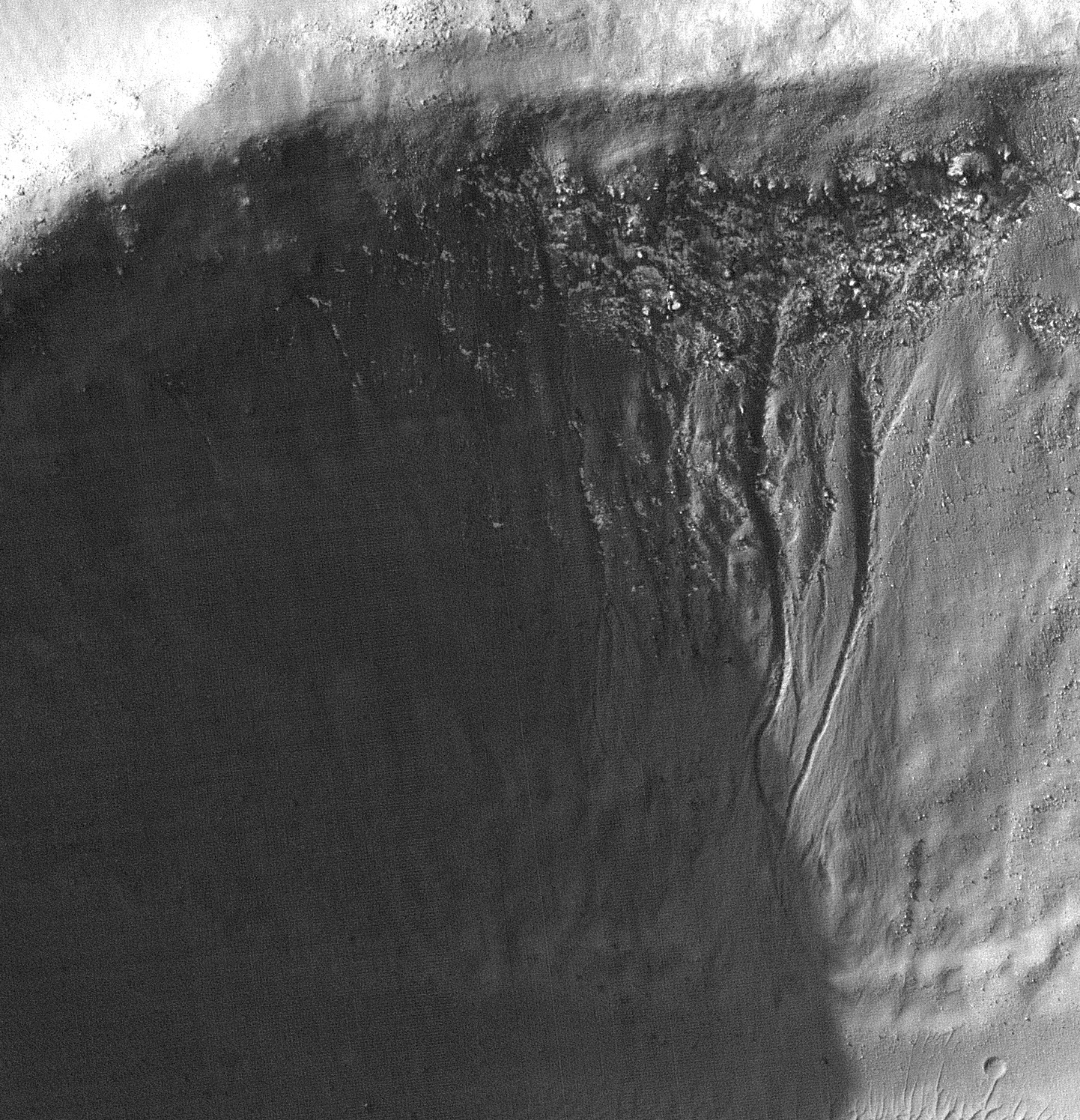
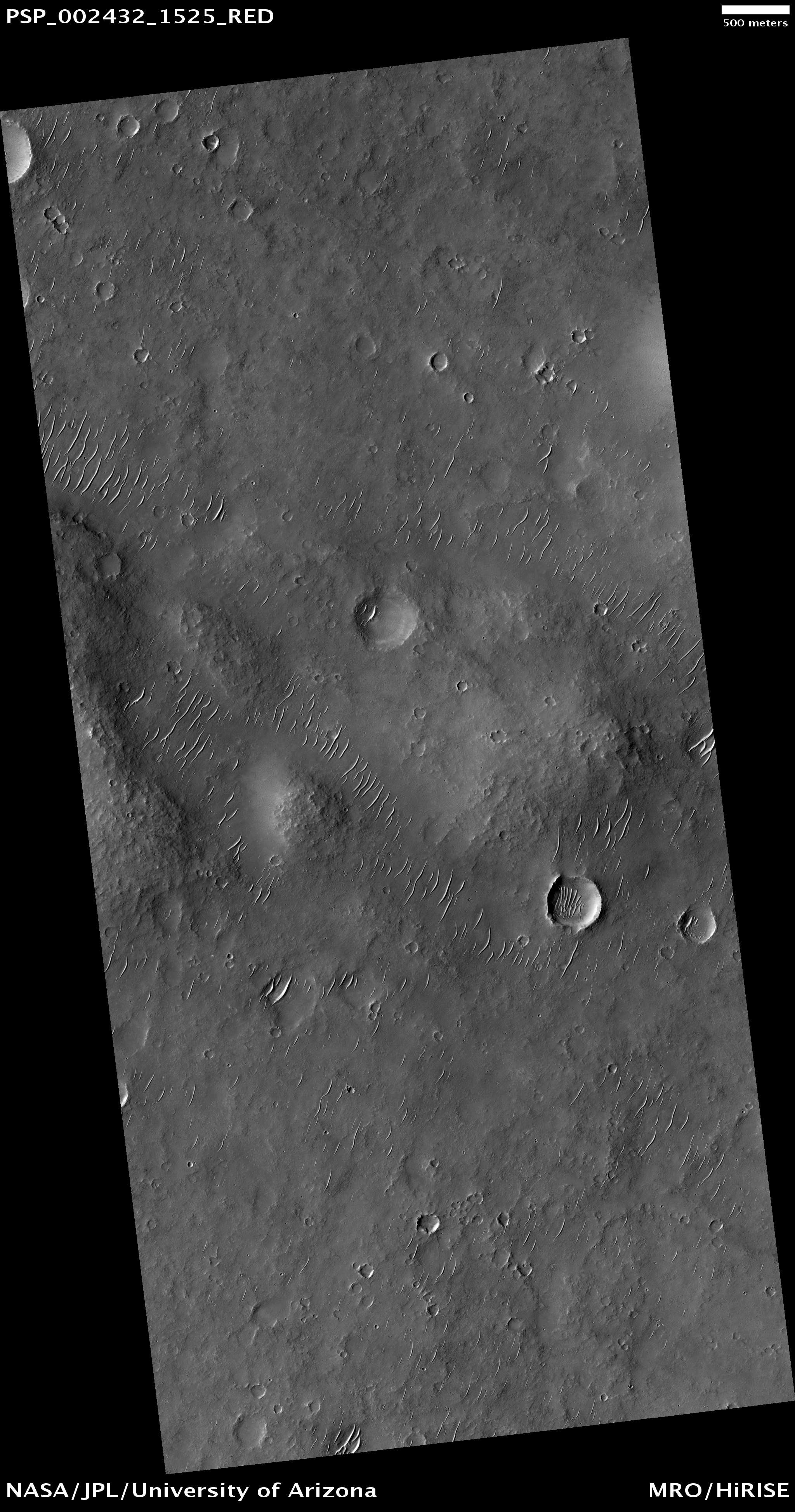
Aeolian Ripples within Slope Streak Beds


Slope streaks, commonly seen in dust-rich equatorial regions of Mars, have been observed in all spacecraft images from the early Mariner missions to the most recent Mars Reconnaissance Orbiter (MRO) mission.

Recently formed slope streaks are typically darker than their surroundings and appear to fade (i.e., brighten) over time. Typical characteristics of slope streaks are initiation at a point source, one streak splitting into two, deflection around or over obstacles such as small boulders or crater rims, widening below the source area up to a few hundred meters, and lengths of up to a few kilometers.

Numerous models have been proposed for their formation, both dry- and wet-based. Although there is not one universally accepted model, one key observation up to now was that streaks do not appear to have topographic relief. However, HiRISE images from the first seven months of MRO showed that slope streaks do indeed have topographic relief: the streak interior is lower than its surroundings. There are also many Martian slope streaks that do not appear to have relief; this does not necessarily mean they lack relief, but rather, the relief is below the capability of HiRISE to detect.

The discovery of topographic relief provides an important clue in that sediment had to be removed for the relief to be present. There are several processes, both wet and dry, that can remove material. A small stream of liquid water running over the surface could carve out the streak area, but liquid water exposed at the surface is not stable under current Martian conditions. Water flowing below the surface, covered by an insulating layer of materials is also possible.

Other evidence that would favor a wet process are detection of salts, alcoves or channels above the point source, or streaks forming at the intersection of two different geologic layers (i.e., permeable and non-permeable layers). However, there are no documented cases of these thus far. Thus, a dry process is appealing and one of these are dry dust avalanches.

Further analyses of the slope streaks have documented features related to modification of the streaks. These include ridge-like structures, which have been interpreted to be aeolian ripples. These ripples indicate that saltation of grains within streak beds are occurring on Mars today, and have likely occurred in the recent past.

Photo credit: NASA/JPL/University of Arizona

Note: This image is located in a bulge region north of Pavonis Mons.

Monday, June 21, 2010

Slope Streaks in Zephyria Planum


Numerous dark slope streaks are visible in this small unnamed crater in Zephyria Planum.

Photo credit: NASA/JPL/Arizona State University

Impact Crater Cut by Faults


This image reveals an interesting coincidence of two important planetary processes: impact cratering and tectonism.

Here we have an impact crater (the large round feature, approximately 6.2 kilometers, or 3.9 miles, across) that intersects a series of faults (the linear features). The faults are seen to cut the circular rim of the impact crater. Also, the impact did not destroy the adjacent faults. These observations tell us that the fault was active after the impact occurred.

In addition, by measuring the distance of offset of the different pieces of the crater rim separated by the fault line (assuming that when the crater formed, the rim was continuous around its circumference), the amount of movement along the fault can be estimated, laterally and vertically. Faults like these cause troughs to form, called graben, of which the heavily shadowed one is a good example. The center (shadowed) section has been dropped downwards relative to the surrounding terrain, forming the trough.

It is also clear that parts of the crater rim are lower than others where the graben intersects the crater. The sides of the graben (the faults forming the walls of the trough) are sloped, so that the dropped-down part of the crater rim has also moved horizontally away from the higher part of the rim. The combined down-dropping and moving apart indicates that the land here is being stretched and pulled apart, called extension. By measuring the amount of offset on all the faults, we can estimate how much extension has occurred in this part of the planet.

This location is especially helpful because, as mentioned above, we have a good knowledge of the “before-faulting” configuration of the land, in which the crater rim was continuous. Finally, it is interesting that there is no sign of the fault on the floor of the crater – the floor has not been faulted and no part is down-dropped and stretched apart as the crater rim has been. This indicates that some infilling of the crater (perhaps by lava or airborne sediment) has likely occurred since the fault was active, burying the trace of the fault and representing a third stage of geologic history in this area.

Photo credit: NASA/JPL/University of Arizona

Note: This image is located in the Phlegathon Catena region east of the volcano Alba Patera.

Sunday, June 20, 2010

Dunes in Tyrrhena Terra


The dunes in this VIS image are located on the floor of an unnamed crater in Tyrrhena Terra.

Photo credit: NASA/JPL/Arizona State University

Dunes and Polygons in Olympia Undae


This observation shows dark dunes and light polygonal terrain in Olympia Undae, also known as the North Polar Erg.

Two sets of dunes are obvious. The major set trends North-South, indicating winds from the East or West. Between the crests of these dunes is a second set oriented mostly East-West.

Zooming in on the dunes, a rippled texture is apparent, probably due to redistribution of sand at the scale of meters and less. Near the crests of some dunes are channel-like features, with some branching downslope. The origin of these channels is unknown, but they may result from the flow and displacement of sand that was fluidized by sublimating carbon dioxide or water frost.

Bright patches of ground are found in some inter-dune areas, with many having a polygonal texture. Polygons on Earth form from contraction induced by stresses from dehydration, cooling, and other processes, so these features may have a similar origin. The CRISM instrument on MRO and OMEGA on Mars Express indicates that many dunes in Olympia Undae are rich in the mineral gypsum.

Photo credit: NASA/JPL/University of Arizona

Saturday, June 19, 2010

Ascraeus Mons


This VIS image shows a portion of the northeastern flank of Ascraeus Mons.

Photo credit: NASA/JPL/Arizona State University

Note: For similar images, see this image of Ascraeus Mons and this image of Pavonis Mons; the caption for the latter photo gives a good explanation for what one sees in the above picture.

Dusty Lava Flows on Ascreaus Mons


Ascreaus Mons is one of the giant shield volcanoes in the Tharsis region of Mars. Based on earlier lower resolution images, this location seemed to be ideal for examining how different types of lava flows interacted.

The smoother ground on the northwest side of the image is probably a lava flow with a relatively smooth crust much like "pahoehoe" lava flows in Hawaii.

The rugged terrain in the southwestern part of the image is indicative of a highly disrupted crust, possibly like what Hawaiians call an "aa" flow. Instead of confirming these hypotheses, HiRISE shows that the lava flow details are obscured by dust. The dust is carved into a curious network of scallops that are too small to have been seen by previous cameras.

Photo credit: NASA/JPL/University of Arizona

Friday, June 18, 2010

Channel in Xanthe Terra


This unnamed channel is located in Xanthe Terra.

Photo credit: NASA/JPL/Arizona State University

Southern Layered Mound and Floor in Gale Crater


This observation shows the interior of Gale Crater, a region being considered as a landing site for the 2011 Mars Science Laboratory.

Gale is distinguished from many other craters on Mars by a large interior layered mound that extends to the height of the crater rim. The top part of this image contains portions of the southeast part of the mound, with the bottom part showing details of the crater floor.

The mound material here is exposed as several distinct smaller hills. Close up, the hills show abundant rocks and debris aprons on their flanks, lacking distinct bedrock layers seen elsewhere on Mars. This suggests that the mound material is friable and easily eroded by the wind over time.

Other evidence of wind activity includes bright bedforms near the top of the image and dark bedforms and sand sheets at bottom. Between the hills and dark sand are a series of stacked stratigraphic units. Polygons are visible in some of the units, indicating contraction due to water loss, cooling, or some other process. Many of the polygons appear highly fractured.

Possible crossbeds are seen in some of the rock exposures near the bottom of the image. This and other images of Gale will be studied over the coming months and years in order to better understand the geology and further assess the potential as a future landing site.

Photo credit: NASA/JPL/University of Arizona

Thursday, June 17, 2010

Dark Slope Streaks in Terra Sabaea


Dark slope streaks, like the ones on the rim of a unnamed crater in Terra Sabaea, are thought to have been formed by material moving down slope due to gravity. As the lighter toned fine materials are removed, the darker toned underlying materials are exposed.

Photo credit: NASA/JPL/Arizona State University

Evolution of the South Polar Residual Cap


As on Earth, the seasonal frost caps of Mars grow and recede each year. But seasonal frost on Mars is composed of carbon dioxide ice (also known as dry ice), not water ice as on our planet.

Near the south pole of Mars, the seasonal carbon dioxide frost never completely disappears, leaving a residual ice cap of carbon dioxide ice throughout the summer. This HiRISE image shows part of the south polar residual cap, with many shallow pits dubbed "Swiss cheese" terrain. Because the sun is always low in the sky at this latitude, the steep walls of the pits receive more solar energy than the high-standing, flat areas between the pits. This causes the walls of the pits to retreat several meters per year as sunlight causes the carbon dioxide ice to evaporate directly to gas, a process called "sublimation."

In some depressions, ridges or blocks of material a couple of meters (several feet) across are visible at the base of the depression walls, likely fallen from the walls during the sublimation and retreat process. At this rate, the layer of carbon dioxide ice could completely disappear in about 100 years if not replenished.

Photo credit: NASA/JPL/University of Arizona

Wednesday, June 16, 2010

Wind Effects Near Medusae Fossae


This region of Mars has been eroded by the wind. Linear hills called yardangs indicate the wind direction, which varies in this area of Medusae Fossae.

Photo credit: NASA/JPL/Arizona State University

Impact Crater Teetering on the Edge of a Canyon


This observation shows the intersection of several geologic features at the edge of the huge Valles Marineris system of canyons on Mars.

The circular feature is an impact crater, roughly 4 kilometers (2.5 miles) across. To the south, terrain slopes downward over 4,000 meters (13,000 feet). Thinking of the crater like a huge drill hole and the canyon wall like a towering road-cut, both features provide a glimpse into the subsurface of the surrounding terrain.

In the curved north wall of the impact crater, and in the East-West trending, upper walls of the canyon (center of the scene), individual layers of rock can be traced laterally over hundreds to thousands of meters (thousands to tens-of-thousands of feet). The layers appear prominently in the wall because they are stronger, steeper, and more resistant to erosion than materials above and below, which form more gradual slopes.

In this scene, darker shadows help to distinguish the steeper, rock layers from lighter, gentler slopes, which are covered with broken rocks and dust. Such layers on Mars may have been deposited by the wind, in water, or by volcanic lava flows or ash falls. Thicknesses and sequences of layering can yield information about how many different events were responsible for their formation, the relative volumes of material involved in each event, and whether a repeating pattern of events of similar type and/or size exists.

The interaction of crater materials and the canyon adds an additional level of interest and complexity to the scene. Normally, when an impact into a layered planetary surface occurs, materials from the center of the crater are pushed downward or blown upward and outward (forming the hole in the ground), while the terrain immediately ringing the crater is tilted upwards to form a relatively narrow, sharp rim as exemplified along the north and southeast edge of this crater. However, the southwest rim of this crater is wider, extends further away from the crater center, is not as circular, and contains several discontinuous pieces of ridges. Either this wall of the crater was pushed further outwards and stretched because the impact occurred near the edge of the canyon (basically allowing the impact to push the wall part-ways over the edge of the canyon), or erosion and expansion of the canyon after formation of the crater has partially undercut the crater wall, causing the wall to slump downwards and outwards.

In either case, it may be possible to learn something about the impact-induced damage and disruption caused in the ground below the rim of a crater; about the strength and structure of post-impact materials in the crater wall; about the effects of impacts on layers farther away or below the crater, and about processes of erosion, canyon growth, and crater formation.

Photo credit: NASA/JPL/University of Arizona

Note: This location is on the northern rim of Capri Chasma.

Tuesday, June 15, 2010

A Channel Into Focas Crater


This image is of a small channel that drains from a small crater into the deeper Focas Crater, named after the Greco-French astronomer, Jean-Henri Focas (1909-1969). Focas Crater is located in Arabia Terra to the south of Mamers Valles.

Photo credit: NASA/JPL/Arizona State University

Southern Hemisphere Craters


This observation shows two southern hemisphere craters. These craters are about the same size, approximately 800 - 900 meters in diameter, and appear to have experienced parallel histories. Both craters show dunes and gullies with similar orientations.

Several generations of dunes can be seen in the interior of these craters. The largest barchan dunes trend northwest-southeast with their slip faces facing the southeast, indicating that the winds forming them came from the northwest.

There are smaller dunes that superpose the large dunes with a different orientation. Different dune orientations are a sign of a changing dominant wind direction. Both craters have similar dune orientations, which is expected because of their proximity.

The two craters also both have gullies originating at layers on their south-facing walls. The gullies are mostly in shadow, but adjusting the brightness and contrast of the image allows them to be seen. The subimage is approximately 300 meters across and shows the gullies in the crater on the right. Gullies are thought to form by liquid water flowing down slopes, but the source of the water and how it is involved in gully erosion is often debated.

One theory proposes that near-surface ground ice melts to form the gullies. An important part of this theory is the direction and amount of insolation (sunlight) a slope receives. Since these craters are close to each other, they receive similar insolation, which could explain why the gullies are in the same location in them.

Another theory suggests that subsurface water from an aquifer forms the gullies. If an extensive aquifer existed, it would flow downslope. If the regional slope trends towards the south, that could explain why the gullies are where they are (the water would come from behind the slope to form the gullies).

HiRISE is showing us unprecedented details of the gullies and will no doubt bring us closer to understanding how these mysterious features form.

Photo credit: NASA/JPL/University of Arizona

Note: These craters lie in Terra Sirenum, and are located to the southwest of the famous Mariner Crater. I discussed Mariner Crater very early on in the history of this blog.

Monday, June 14, 2010

Capri Chasma


This VIS image shows a small portion of the floor of Capri Chasma. Bright layered deposits and dunes are visible in this image.

Photo credit: NASA/JPL/Arizona State University

Ancient Terrain Near Tyrrhena Patera


This observation covers a small part of the plains surrounding the volcano Tyrrhena Patera.

Most of this area is covered by a thick layer of "mantling" material which hides the underlying rocks. Infrared data from the Mars Odyssey spacecraft suggested that this area is rockier than most of the region.

The center of the image is at full resolution, but the outer edges have averaged each group of 4 x 4 pixels. This reduces the amount of data that needs to be returned to Earth and helps ascertain how much resolution is actually needed to study this kind of terrain.

This observation confirms that the area is unusually rocky, with some bare patches of ancient shattered rock exposed at the surface. This image is also a good example of how the HiRISE team samples unknown terrain.

Photo credit: NASA/JPL/University of Arizona

Sunday, June 13, 2010

Tithonium Chasma


Two landslide deposits are visible in this image of Tithonium Chasma.

Photo credit: NASA/JPL/Arizona State University

Dusty Volcanic Vent in Syria Planum


Previous images of this area by other space missions indicate that this is a shield volcano with very shallow slopes. What HiRISE reveals is that it is completely covered by a blanket of dust.

While volcanic features remain obscure, the dust does exhibit some very strange patterns. As you zoom into the middle of the image, the ground appears covered with a fine network of light and dark polygons. But at full resolution, it can be seen that these polygons are actually the edges of small scallops.

The dust is apparently held together by some unknown means, giving it sufficient strength to be carved into this strange pattern.

Photo credit: NASA/JPL/University of Arizona

Note: This volcano is located near the center of Syria Planum, which itself lies south of Noctis Labyrinthus.

Saturday, June 12, 2010

Shalbatana Vallis


This VIS image shows a complex tributary channel and its entry to the main channel of Shalbatana Vallis.

Photo credit: NASA/JPL/Arizona State University

Sample Tharsis Tholus Caldera Wall


This image captures one of the cleaner portions of the interior wall of the caldera at the top of Tharsis Tholus.

Tharsis Tholus is an intermediate sized shield volcano, much smaller than giants such as Olympus Mons, but still large by terrestrial standards. While relatively dust-free, this section of the caldera wall is still extensively covered by dust that is being sculpted into curious shapes by the wind and by gravity.

Photo credit: NASA/JPL/University of Arizona

Note: I love this photo in that it reminds me of your typical snow-covered mountain photo and, yet, there is no snow in this picture; it's all dust. Just another reminder of the alienness of Mars.

Friday, June 11, 2010

Arabia Terra


This small channel is located on the northern margin of Arabia Terra.

Photo credit: NASA/JPL/Arizona State University

Ancient Lava Plain in Thaumasia Planum


This observation samples part of an ancient lava plain in Thaumasia Planum. The stack of lava flows has been folded into dunes the size of a chain of hills, as is visible in the center of the image.

The lava and the dunes has been degraded by erosion. The numerous craters and dunes attest to two of the erosional processes—meteorite impacts and the wind.

Photo credit: NASA/JPL/University of Arizona

Note: Thaumasia Planum is an upland region in Mars' southern hemisphere directly south of Coprates Chasma. It lies in the Thaumasia Quadrangle.

Thursday, June 10, 2010

Ophir Chasma


This VIS image shows a landslide deposit in Ophir Chasma.

Photo credit: NASA/JPL/Arizona State University

Distal Rampart of Crater in Chryse Planitia


Impact craters on Mars are kind of neat: many of them look very different than impact craters seen on the Moon or Mercury.

Fresh lunar and Mercurian craters have ejecta blankets that look a bit rough near the crater rims; around larger craters, long rays or chains of secondary craters radiate away from the crater rims. Some Martian craters are similar to these craters, but Mars also has a high proportion of craters with forms not found on the Moon or Mercury: rampart craters.

Rampart craters, also called fluidized-ejecta craters, have ejecta blankets that appear lobate, or rounded, and end in low ridges or ramparts, such as the ridge in this HiRISE image. Here you see the rampart at the edge of the ejecta blanket that comes from an approximately 16 kilometer (10 mile)-diameter crater, about 16 km (10 mi) to the east.

For years there has been a debate about whether these lobes and ramparts were formed by ejecta interacting with the thin Martian atmosphere, or whether they formed because volatiles (such as water or ice) in the subsurface were incorporated into the ejecta material excavated by the impact. The common consensus is now in favor of the volatile hypothesis. Because of this, rampart craters can be used to indicate the past presence of water or ice in the Martian crust.

Photo credit: NASA/JPL/University of Arizona

Notes: This image is located in the southwestern uplands of Chryse Planitia. The Viking 1 Lander is due north from this location.

Wednesday, June 9, 2010

Eos Chasma


At the eastern end of Valles Marineris is Eos Chasma. In Eos the canyon system transitions into a region of chaos and then into major outflow channels. This image shows the transition into chaos.

Photo credit: NASA/JPL/Arizona State University

Comanche Outcrop Contained Carbonates


Lengthy detective work with data NASA's Mars Exploration Rover Spirit collected in late 2005 has confirmed that an outcrop called "Comanche" contains a mineral indicating that a past environment was wet and non-acidic, possibly favorable to life.

Spirit used its panoramic camera to capture this view of the Comanche outcrop during the 689th Martian day, or sol, of the rover's mission on Mars (December 11, 2005). The rover's Moessbauer spectrometer, miniature thermal emission spectrometer and alpha particle X-ray spectrometer each examined targets on Comanche that month. On June 3, 2010, scientists using data from all three spectrometers reported that about one-fourth of the composition of Comanche is magnesium iron carbonate. That concentration is 10 times higher than for any previously identified carbonate in a Martian rock.

Carbonates originate in wet, near-neutral conditions but dissolve in acid. The find at Comanche is the first unambiguous evidence from either Spirit or its twin, Opportunity, for a past Martian environment that may have been more favorable to life than the wet but acidic conditions indicated by the rovers' earlier finds.

In this image, Comanche is the dark reddish mound above the center of the view. The image is presented in false color, which makes some differences between materials easier to see. It combines three separate exposures taken through filters admitting wavelengths of 750 nanometers, 530 nanometers and 430 nanometers. The main Comanche outcrop is about 5 meters (16 feet) from left to right from this perspective. The paler material visible at bottom right is part of another outcrop, "Algonquin."


Photo credit: NASA/JPL-Caltech/Cornell University

Note: The Comanche outcrop is to the southeast of the summit of Husband Hill, and is on the route Spirit took to the plateau known as Home Plate. See this map, which shows Spirit's route since its landing on Mars.

Update: I just happened to find this short NASA-produced video about this story:

Tuesday, June 8, 2010

Terra Sabaea


Gravity has caused materials to move down the rim of this crater in Terra Sabaea. Here, thinner dark slope streaks are less common than broader, lighter markings of downslope movement of materials.

Photo credit: NASA/JPL/Arizona State University

Exposures of Different Rocks in Eos Chasma


The bright rock exposures in this image occur along the walls of a 60-kilometer diameter impact crater.

The crater penetrated into rocks that are made of different kinds of sulfates. The sulfates appear brighter than most other rocks commonly found on Mars, like basaltic lava flows. Within the sulfates there may be small particles (below the 25 centimeter/pixel resolution of HiRISE) composed of iron in the form of hematite (Fe2O3).

Scientists are able to use spectral information from instruments like the Compact Reconnaissance Imaging Spectrometer for Mars (CRISM) and the Thermal Emission Spectrometer (TES) to identify minerals like sulfates and hematite on the surface of Mars. The occurrence of these two minerals at this location suggests that water once existed here in the past.

Photo credit: NASA/JPL/University of Arizona

Note: This crater is located in the uplands just south of Capri Chasma.

Monday, June 7, 2010

Lava Flows Near a Crater Rim in Daedalia Planum


In some regions of Mars the relative ages of different materials can be determined. One example is shown in this VIS image. Here the younger lava flows of Daedalia Planum are on top of the older Terra Sirenum materials. The crater rim of older material is inundated by the younger flows.

Photo credit: NASA/JPL/Arizona State University

Northern Hemisphere Gullies on West-Facing Crater Slope


This image shows the eastern (west-facing) side of an impact crater in the mid-latitudes of the Northern hemisphere.

Like many mid-latitude craters, this one has gullies along its walls that are composed of alcoves, channels, and debris aprons. The origins of these gullies have been the subject of much debate; they could have formed by flowing water, liquid carbon dioxide, or dry granular flows. The orientation of these gullies is of interest because many craters only contain gullies on certain walls, such as those that are pole-facing. This could be due to changes in orbital conditions and differences in solar heating along specific walls.

Many of the other features observed in and around this crater however are indicative of an ice-rich terrain, which may lend credence to the water formation hypothesis, at least for the gullies visible here. The most notable of these features is the "scalloped" terrain in and around the crater. This type of terrain has been interpreted as a sign of surface caving, perhaps due to sublimation of underlying ice. (Sublimation is the process of a solid changing directly to a gas.)

Another sign of ice is the presence of parallel lineations and pitted material on the floor of the crater, similar to what is referred to as concentric crater fill. Parallel linear cracks are also observed along the crater wall over the gullies, which could be due to thermal contraction of ice-rich material.

All of these features taken together are evidence for ice-rich material having been deposited in this region during different climatic conditions that has subsequently begun to melt and/or sublimate under current conditions. More recently, aeolian deposits have accumulated around the crater as evidenced by the parallel ridges dominating the landscape. Dust devil streaks are also visible crossing the aeolian ridges.

Photo credit: NASA/JPL/University of Arizona

Note: This crater is located in the Utopia Rupes region, which is in the northwestern corner of Utopia Planitia.

Sunday, June 6, 2010

Dunes in Briault Crater


These individual dunes are located on the floor of Briault Crater.

Photo credit: NASA/JPL/Arizona State University

Notes: Briault Crater, which is named after the French astronomer, P. Briault, lies in Tyrrhena Terra.

Flow Features in Amazonis Planitia


Located between the Tharsis and Elysium volcanic provinces, Amazonis Planitia's relatively smooth surface and sparseness of sizeable craters has made it a good example for the most recent period in Mars' geological history. The "Amazonian" spans roughly the first several hundred million years of Mars' history.

Although Amazonis Planitia is considered one of the smoothest areas on Mars, it is not featureless. The surface is covered with small sinuous ridges that are several hundred meters in length. Spanning across the image are larger continuous ridges and troughs that trend in a roughly North-South direction and cut across the smaller ridges. The formation of these features is consistent with large-scale lava flow activity. Sediment fills in the lower topography between these ridges, and occasionally accumulates into larger dunes. These dunes likely formed from particles eroded off the ridges over time and are shaped by the prevailing winds. Interestingly, these dunes are isolated from each other by several hundreds of meters.

Studying terrains like those in this image allows researchers to characterize more recent surface processes on Mars, thus helping to piece together the planet's geologic history.

Photo credit: NASA/JPL/University of Arizona

Saturday, June 5, 2010

Pavonis Mons


This image is of a tiny sliver of the eastern flank of Pavonis Mons. The very base of the volcano is the left-hand side of the image, whereas the right-hand side is the plain upon which the mountain rests. Pavonis Mons is the middle of the three "Prince" volcanoes on the Tharsis bulge.

Of interest is the three sets of pits that curve around near the base of the mountain. Each set of pits is probably a lava tube in which skylights opened up; the resulting pit caves then filled up with sand and dust over time. These pits differ from the recently-discussed pits on Arsia Mons (see Chain of Pits on Arsia Mons and Anaglyph of Arsia Mons' Chain of Pits) in that the latter are all in a straight line, thus probably being a fault in which the ground was pulled apart, as opposed to the Pavonis Mons pits, which are all curved, which is more typical of lava tubes.

Photo credit: NASA/JPL/Arizona State University

Exposed Light Material in Upland Region in Aureum Chaos


The plateau visible in this image is located within Aureum Chaos. Chaotic terrains on Mars are blocky, fractured regions of flat-topped hills, plateaus, plains, and depressions thought to have formed by the collapse of the heavily cratered uplands.

Large outflow channels appear to emerge from Aureum Chaos and other chaotic terrains leading researchers to posit that these large collapse regions were formed by the catastrophic release of ground water. Aureum Chaos is located just to the northeast of Valles Marineris adjacent to Margaritifer Terra, and it has a diameter of approximately 368 kilometers.

The steep-sided plateau in this image has a sharp, undulating surface possibly etched out and eroded by persistent winds. These same winds may well have transported the resulting sediment to the surrounding plains helping to form the dunes below. The plateau slopes are steep and consist of a series of parallel bright, more resistant cliff forming layers and darker, less resistant slope material. A good way to see the differences in color between the plateau's bright layered deposits and the surrounding area is to look at some of the blocks that have fallen off the cliff onto the the dark sands below.

By studying areas of Mars such as this one, researchers hope to understand how the chaos regions formed and how their formation related to the release of ground water to form the outflow channels, if indeed the two are connected in this way.

Photo credit: NASA/JPL/University of Arizona

Friday, June 4, 2010

Wind Effects Near Zephyria Planum


Located on the margin of Zephyria Planum, today's image shows the effect the wind has had on the surface of Mars. Loose materials have been removed and semi-consolidated materials have been eroded into narrow hill forms.

Photo credit: NASA/JPL/Arizona State University

Note: Zephyria Planum is a peninsula-shaped lobe of upraised land that extends to the northwest from the border terrain separating the southern highlands from Elysium Planitia.

Low Albedo Feature in Aeolis and Zephyria Regions


This image is taken of an interesting linear feature in the Aeolis and Zephyria regions. Using the daytime infrared imaging data from the THEMIS instrument, this feature has a higher daytime temperature than its surroundings while also being relatively dark.

When viewed at full HiRISE resolution, this area contains sand ripples with some consolidated, bedrock-like material poking through. These bedrock outcrops are more pronounced along the southern portion of the image and are most apparent in the region of the thermal anomaly. The outcrops trend generally East-West and appear sculpted by aeolian erosion.

In the area of the anomaly, the sand between these outcrops has a darker tone and gradually blends with the lighter material to either side. This darker sand may be the reason why the material has a "hot" signature compared to its surroundings, because dark materials absorb sunlight more efficiently.

Features similar to the one in this image help researchers to characterize such features and to understand whether such exposures may indicate possible hydrothermal fissures, or perhaps be just an exposure of a darker underlying material.

Photo credit: NASA/JPL/University of Arizona

Note: Aeolis Planum and Zephyria Planum are two peninsula-shaped lobes of upraised land that extend to the northwest from the border terrain separating the southern highlands from Elysium Planitia.

Thursday, June 3, 2010

Coprates Chasma


The floor of Coprates Chasma contains many different geologic landforms. This VIS image shows the effects of wind and landslides.

Photo credit: NASA/JPL/Arizona State University

Light-Toned Deposits in Noctis Labyrinthus


CRISM observations of this region of the Noctis Labyrinthus formation have shown indications of iron-bearing sulfates and phyllosilicate (clay) minerals.

HiRISE observations have revealed exposed layers which are possibly the sources of the signatures seen by CRISM. In the subimage, the layering can be seen in the lower part of the image. To the upper left one can see a dune field which covers other beds.

Photo credit: NASA/JPL/University of Arizona

Wednesday, June 2, 2010

Patapsco Vallis


This VIS image shows a portion of Patapsco Vallis, a channel located on the eastern margin of Elysium Mons.

Photo credit: NASA/JPL/Arizona State University

Polygonal Ridges in Gordii Dorsum


This image from the Gordii Dorsum region of Mars shows a large area covered with polygonal ridges in an almost geometric pattern.

The ridges may have originally been dunes which hardened (indurated) through the action of an unknown process. Groundwater might have been involved.

Photo credit: NASA/JPL/University of Arizona

Notes: Gordii Dorsum is a long peninsula of raised land that juts out of the southern highlands into Amazonis Planitia; it is located to the southwest of the Tharsis bulge and Olympus Mons. This particular image is located near the northeastern tip of Gordii Dorsum.

Tuesday, June 1, 2010

Elysium Fractures


The fractures in this VIS image are located on the northwestern flank of the Elysium Mons volcanic complex.

Photo credit: NASA/JPL/Arizona State University

Gully Landforms in Aram Chaos


This observation shows erosional features on light-toned rocks in Aram Chaos, a crater near the equator of Mars that has been nearly filled with sedimentary rocks.

In enhanced color, the sediments are very distinctive. The rocks show a sharp change in color partway down the slope, indicating a change in the properties of the rock, probably to a different composition.

The erosional features have alcoves with aprons downslope, and in some cases have hints of channels, potentially due to abrasion by falling debris. These morphologies bear some resemblance to gullies commonly found in the mid-latitudes, which are often thought to have formed due to erosion by liquid water from melting snow. Near the equator, however, snowmelt in Mars' recent climate is less likely.

Photo credit: NASA/JPL/University of Arizona