Tuesday, May 11, 2010

Two Worlds, One Sun


While humans' lives unfolded on Earth, NASA's Mars Exploration Rover Opportunity paused in its southward trek and captured this photomosaic around 15:00 local Mars time on May 2, 2010. ... Dusty, reddish brown dunes stretch southward to the horizon along the rover's route ahead.

The "Two Worlds, One Sun" theme is a reference to the motto inscribed on the Pancam calibration target, seen on the back of the rover deck at the bottom of this view. The target is used to properly calibrate and color-balance the Pancam images, and with its artistically styled shadow post, or gnomon, it doubles as a sundial (also known as a "Marsdial") for educational purposes. (See PIA05018.)

This scene is a three-tall by one-wide mosaic of Pancam images taken through the camera's red (602 nanometer), green (530 nanometer) and blue (480 nanometer) filters. It has been calibrated and processed to approximate the colors that would be seen by humans if they could be present for this lovely Martian view. The camera took the images during the 2,229th Martian day, or sol, of Opportunity's mission on Mars.

Photo credit: NASA/JPL-Caltech/Cornell University

Pits along Fractures in Crater Floor Material


This image shows the degraded rim of a large impact crater which is partly filled with material that is fractured in several places, especially near the crater rim.

Pits of various sizes have formed along most of the fractures, and some of the pits have merged into elongated depressions. The association of the pits with the fractures suggests that the pits were formed by removal of material deep within the fractures. A plausible reason for the formation of these features is that the crater floor material includes substantial ground ice. When the fractures open, perhaps due to glacial-like flow of the ice-rich floor material toward the center of the crater, water ice is exposed to the Martian atmosphere.

The ice then evaporates into the dry atmosphere, enlarging the fracture at depth. As the icy "cave" grows, ice-free material near the surface collapses into the cave, forming the pits we see here.

Photo credit: NASA/JPL/University of Arizona

Note: This crater is located in the fretted terrain of Protonilus Mensae. The closest named feature to this crater is Renaudot Crater, which is to the southeast.

Monday, May 10, 2010

Capri Chasma


This VIS image shows a portion of Capri Chasma. Dunes are found on the floor of this chasma.

Photo credit: NASA/JPL/Arizona State University

Note: Capri Chasma is part of the larger Valles Marineris System, located just south of Aurorae Planum and east of Coprates Chasma.

Big Impact-Triggered Dust Avalanche


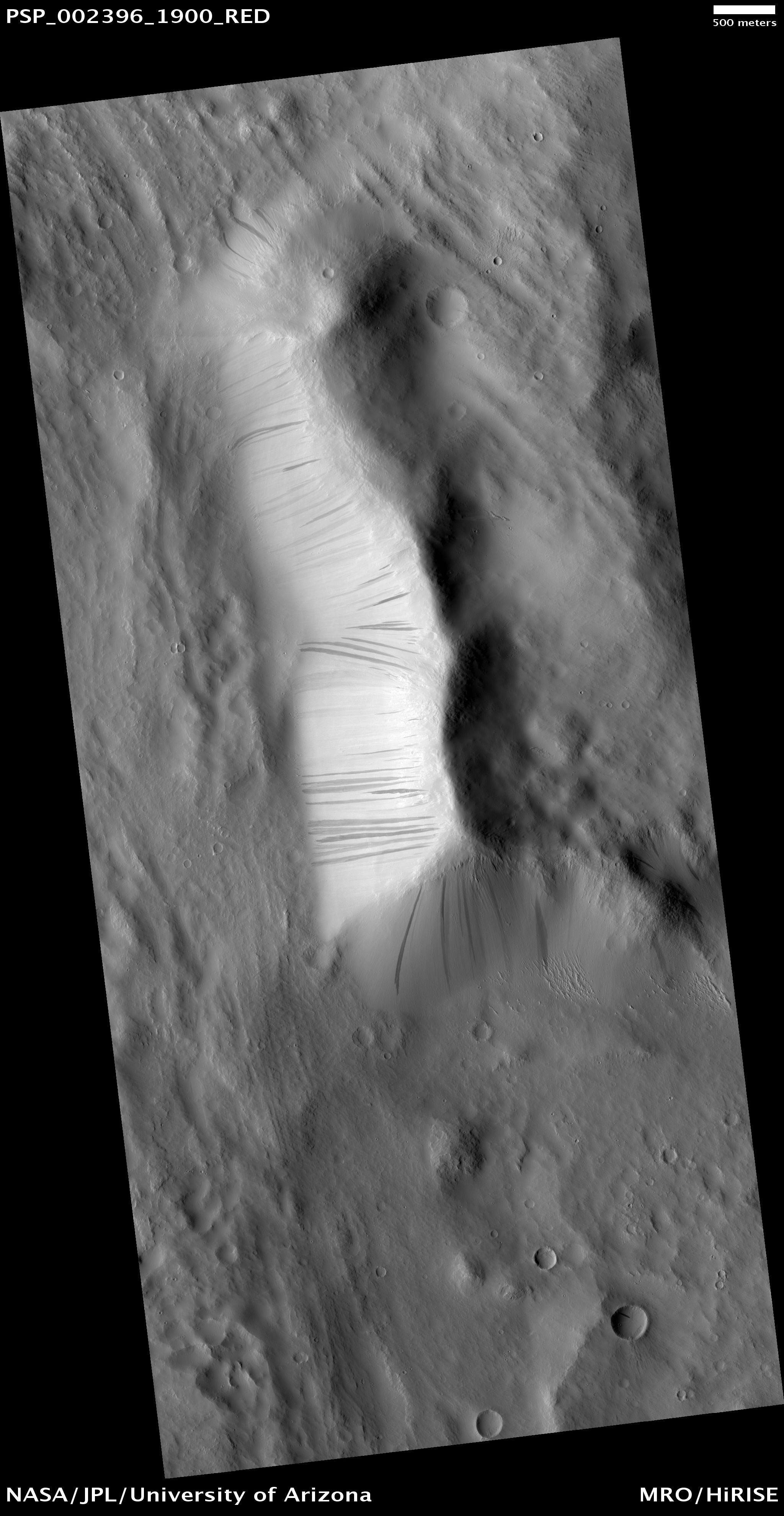
MRO's Context camera (CTX) acquired the image at lower left on 18 November 2007 and the adjacent image on 14 February 2010, showing a large new slope streak in the aureole (giant landslide deposits) of Olympus Mons.

Slope streaks (dust avalanches) are common on Mars but this one is unusually wide and it began from an unusual extended/fuzzy source area. HiRISE acquired the follow-up image (right) 31 March 2010, revealing a small, pristine impact crater (blue arrow) in the fuzzy source area, which resembles the airblast patterns seen at many other new (recent year) impact sites. We've conclude that an impact event occurred sometime between the dates of the CTX images and triggered a large dust avalanche.


Photo credit: NASA/JPL/University of Arizona

Sunday, May 9, 2010

Lava Flows in the Tharsis Region


This VIS image in the Tharsis region shows a lava flow that topped the rim of an impact crater and flowed down to the floor of the crater.

Photo credit: NASA/JPL/Arizona State University

Deformed Craters and Polygons in Utopia Planitia


This image of Utopia Planitia shows some deformed craters. The crater rims are not round but elliptical and even angular.

The region is interesting because there are surface features (e.g., polygonal cracks) which suggest that water ice is close to the surface. A good example is just to the south of the featured image here. Other craters in the area appear old and eroded. Many are filled with material which could contain quantities of water ice. Were these deformed craters the result of an oblique impact or were they deformed afterwards by an as-yet unknown process?

Photo credit: NASA/JPL/University of Arizona

Saturday, May 8, 2010

Intra-Crater Structure in NW Hellas Basin


This subimage from an observation by the High Resolution Imaging Science Experiment (HiRISE) camera on NASA's Mars Reconnaissance Orbiter covers a small portion of the northwest quadrant of Hellas Basin, or Hellas Planitia, on southern Mars. With a diameter of about 2,200 kilometers (about 1,400 miles) and a depth reaching the lowest elevations on Mars, Hellas is one of the largest impact craters in the solar system.

This area of Hellas Basin has a number of unusual features which are thought to be quite old because of the high crater density. Here a crater inside Hellas has been filled with material. This may be related to volcanic activity on the northwestern rim of Hellas.

However, it might also be related to water and water ice. There is evidence elsewhere that the ground here is ice-rich. HiRISE is being used to investigate this in more detail when Hellas Basin is free from atmospheric dust.

Photo credit: NASA/JPL-Caltech/University of Arizona

Note: Fore more photos and information about this formation, see here.

Knobs near Reull Vallis


This observation shows a knob and large crater near Reull Vallis, east of the Hellas Basin. The crater's ejecta blanket abuts the base of the knob. The crater floor and ejecta are blanketed with an ice-rich mantle that is common throughout the Martian mid-latitudes.

The mantle deposits are pitted and grooved perhaps due to the sublimation of ice. This mantle is thought to have been deposited as snow around 10 million years ago during a period of high obliquity, when the planet's axis was more tilted and environmental conditions could have been more conducive to snowfall in these regions.

Several small impact craters are visible on the ejecta blanket that appear to have been filled with mantling deposits that have since been partially removed. These craters give us clues to the erosional history of the deposit. Note the fresh looking impact crater at the top of the knob. This crater does not appear to contain mantling deposits and may be much younger.

This region contains many mesas surrounded by lobate debris aprons that are thought to be ice-rich. These aprons have been interpreted as a variety of possible features including rock glaciers, ice-rich mass movements, or debris-covered glacial flows. Reull Vallis itself is filled with what is referred to as "fretted terrain," which is also thought to be ice-rich material.

Photo credit: NASA/JPL/University of Arizona

Friday, May 7, 2010

Ganges Chasma


This VIS image of Ganges Chasma shows where a large portion of the canyon wall has given way and formed a landslide deposit. Large landslides deposits are common features in Valles Marineris and the surrounding chasmata.

Photo credit: NASA/JPL/Arizona State University

Light-Toned Rocks inside a Crater


This approximately 20 kilometer diameter impact crater is located just to the south of Coprates Chasma in Valles Marineris.

Near the center of the crater are some light-toned rocks. These rocks are very jumbled and broken up rather than flat-lying and layered. These observations suggest that the light-toned rocks once existed below the current terrain and were brought up by the process that created the crater.

Several other craters around Valles Marineris also reveal light-toned rocks in their central peaks suggesting that the light-toned rocks are a regional unit that is buried beneath the lava plains that now surround Valles Marineris.

Photo credit: NASA/JPL/University of Arizona

Thursday, May 6, 2010

Rhabon Valles


This VIS image shows a portion of Rhabon Valles, a channel south of Uranius Mons.

Photo credit: NASA/JPL/Arizona State University

Endeavour Crater on the Horizon


NASA's Mars Exploration Rover Opportunity used its panoramic camera (Pancam) to capture this view of the rim of Endeavour crater, the rover's destination in a multi-year traverse along the sandy Martian landscape. The image was taken during the 2,226 Martian day, or sol, of Opportunity's mission on Mars (April 28, 2010).

Endeavour is 21 kilometers (13 miles) in diameter, about 25 times wider than Victoria crater, the last major crater Opportunity visited. This image shows an outcrop of rocks at the foot of the rover and beyond these rocks rippled dunes, which are about 20 centimeters (8 inches) tall. The west rim of Endeavour, about 13 kilometers (8 miles) away, appears on the left on the horizon. The rim of smaller, more-distant Iazu crater, which is 7 kilometers (4 miles) in diameter and about 35 kilometers (22 miles) away, is on the far right. On the horizon in between is a blanket of material ejected from the impact that created Iazu crater, and darker features that are portions of the west and southwest rim of Endeavour.

Opportunity began a marathon from Victoria to Endeavour in September 2008 after spending two years exploring Victoria. The intended route, about 19 kilometers (12 miles) long, has headed south before turning east in order to bypass potentially hazardous sand ripples to the east, larger than the ripples in this image.

This approximately true-color view combines three exposures taken through filters admitting wavelengths of 750 nanometers, 530 nanometers and 430 nanometers.

Photo credit: NASA/JPL-Caltech/Cornell University

Wednesday, May 5, 2010

Coprates Crater in Coprates Chasma


Impact craters can be created anywhere on the surface of Mars at any time. This crater is located on the floor of Coprates Chasma.

Photo credit: NASA/JPL/Arizona State University

Reading the Geologic Record


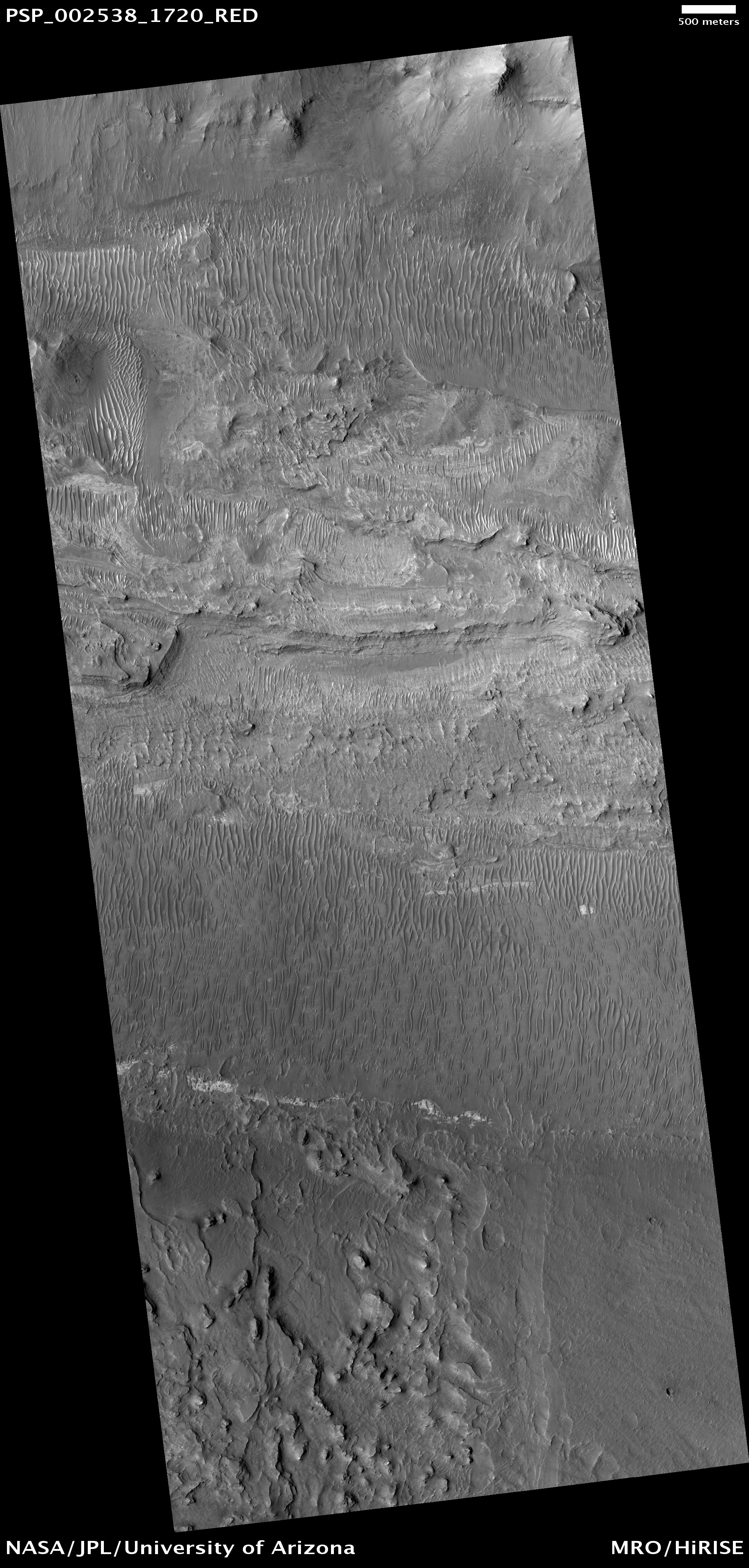
This observation shows a series of parallel layers eroding into peculiar knobs and hills.

These sedimentary rocks were imaged on the floor of a large crater located at 8.8 degrees North, 358.3 degrees East. Similar rock units are found within several nearby craters also imaged by HiRISE, as seen in images PSP_001902_1890, ESP_013611_1910, and PSP_002733_1880. The occurrence of similar layers in each of these locations may indicate that they were once part of a much more extensive geologic unit that has now been largely eroded away.

One particularly interesting aspect of the layers in this image is their repetitive nature. Each layer appears to be nearly the same thickness throughout the outcrop, as has also been observed in other nearby layered units. This cyclic nature points to a formation process which occurred repeatedly, building up the deposit layer by layer. However, the exact formation mechanism and the climate cycle possibly responsible for forming the layers here remain unknown.

Studying the record exposed in rocks like these can help reveal secrets of the ancient Martian climate.

Photo credit: NASA/JPL/University of Arizona

Note: This crater is located in the Arabia Terra region; the closest named landmark to this crater is Marth Crater.

Tuesday, May 4, 2010

Orbital View of Opportunity's Region


This view of an area about 140 kilometers (about 90 miles) wide in the Meridiani Planum region of Mars shows the region around NASA's Mars Exploration Rover Opportunity. Opportunity, in the seventh year of its exploration of Mars, is in the upper central portion of the image, on multi-year trek from Victoria crater toward the much larger Endeavour crater. In April 2010, Opportunity captured views of the rims of Endeavour crater and the more distant Iazu crater on the horizon to southeast from the rover. (See PIA13081 and PIA13080.) The rover's position relative to those craters is indicated here.

This view is a mosaic of daytime infrared images taken by the Thermal Emission Imaging System (THEMIS) camera on NASA's Mars Odyssey orbiter.

Below is an annotated version of the above mosaic:


Photo credit: NASA/JPL-Caltech/Arizona State University

Gullied Trough in Noachis Terra


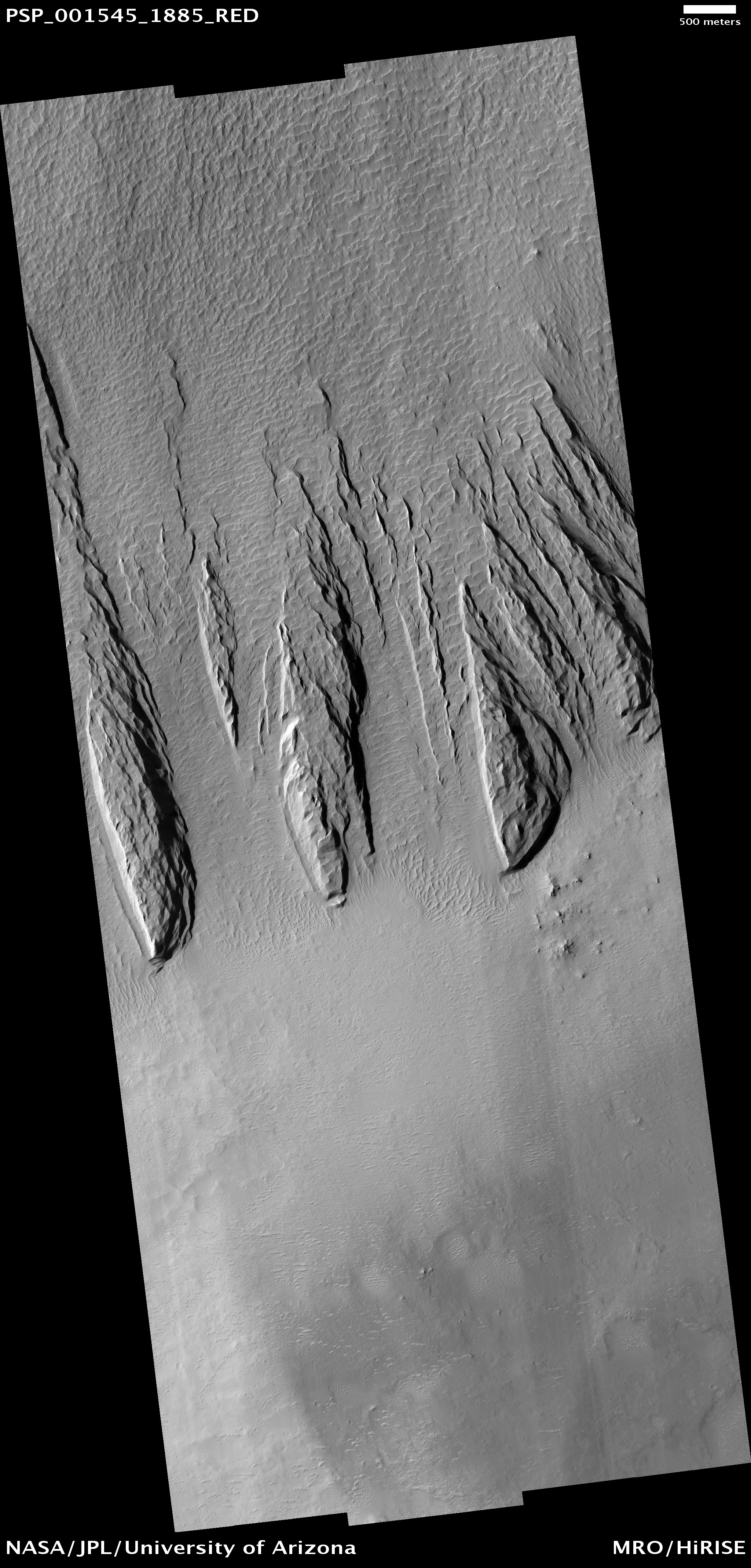
This observation shows gullies in a semi-circular trough in Noachis Terra. The gullies are observed to face all directions.

It is interesting to note that the gully morphology seen here depends on the orientation of the gullies. The morphology differences are most pronounced on the sunlit slope, with the gullies facing south (down) being more deeply incised than those facing the west. It is unknown what caused the different gully morphologies, but there are several possibilities.

Gullies are proposed to form at locations determined by the availability of a forming liquid (thought to be water) and/or the amount of insolation the slope receives, among other factors. It is possible that the deeper gullies experienced more erosional events or that their erosional events were more effective for undetermined reasons. It is also possible that the gullies formed at different times such that they did not have the same amount of water — either for an individual flow or total — available to them. Also, the underlying topography could make the gullies appear relatively more incised without this actually being the case.

The majority of the gullies on both sides of the trough appear to originate at a boulder-rich layer visible in the subimage. The layer appears dark on the sunlit slope because the boulders sticking out from the slopes cast shadows. If these gullies formed by water from the subsurface, then it is possible that this layer is a permeable layer that conducted water to the surface. The layer is deteriorating and traveling down slope in the form of boulders. These boulders can clearly be seen in the alcoves of the gullies on both sides of the trough.

Note that the alternating stripes on the left side of the image are an artifact from camera noise. They are not real features.

Photo credit: NASA/JPL/University of Arizona

Monday, May 3, 2010

Galaxias Fossae


The fracture system in this VIS image is part of Galaxias Fossae, a series of fractures on the northern part of the Elysium Mons volcanic complex.

Photo credit: NASA/JPL/Arizona State University

Newly-Formed Slope Streaks


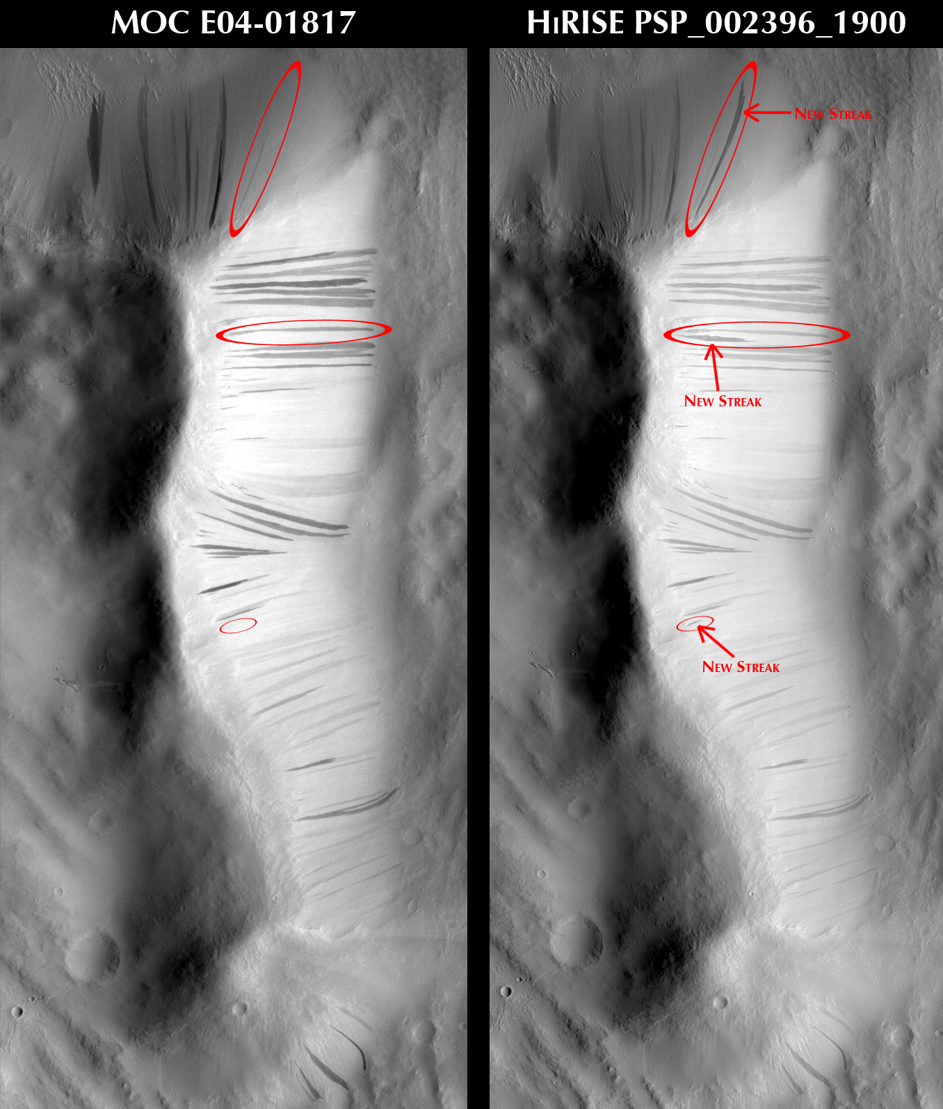
This observation features three newly-formed slope streaks. These are features which occur on crater walls, hills, and other slopes on Mars.

They always begin at a point source and widen downslope, sometimes weaving around existing topographic features (such as dunes or craters), but other times they flow over them. Many slope streaks do not show topographic relief in available images, and there are no observable deposits of displaced materials surrounding their borders.

In general, slope streaks tend to be many hundreds of meters long and less than 200 meters wide. They are observed in varying shades of darkness, where lighter-toned streaks appear to be older than darker ones. The formation mechanism responsible for slope streaks is still under debate; theories range from dry dust avalanches (most widely-accepted theory) to briney water seepage.

Slope streak formation is among the few surface processes known to be currently active on Mars, making slope streaks some of the youngest features on Mars. A comparison of this HiRISE image with MOC image E04-01817 shows that three new slope streaks have formed during the six years separating these images (2001 - 2007). The shortest time frame in which new slope streaks have been observed to form is six months (MOC images SP2-37303 and E02-02379), though it is not yet known how long it actually takes for a slope streak to form.

Photo credits: NASA/JPL/University of Arizona; MOC Image E04-01817: NASA/JPL/Malin Space Science Systems.

Note: These slope streaks are located in Amazonis Planitia to the northwest of Eumenides Dorsum.

Sunday, May 2, 2010

Juventae Chasma


Baetis Chasma is a chasmata near Valles Marineris. It is not directly connected to Valles Marineris, but contains some of the same features seen in the larger chasmata. Dunes are prevalent on the floor of this portion of Juventae Chasma.

Photo credit: NASA/JPL/Arizona State University

Proctor Crater Dune Field


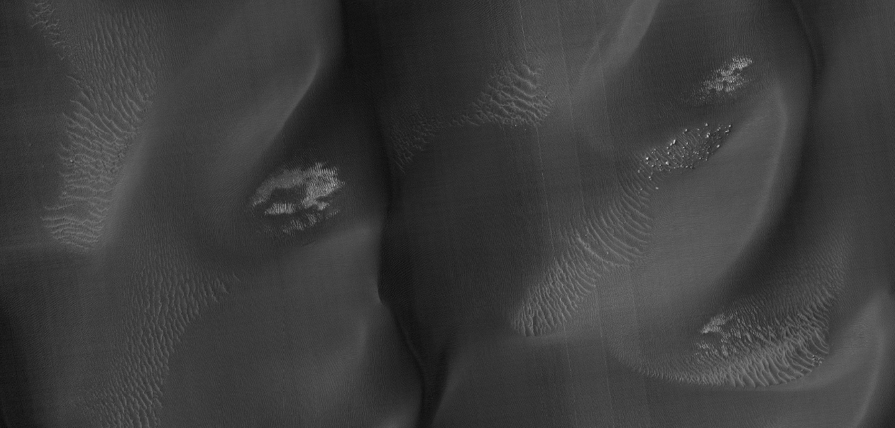
This observation shows the edge of a dark dune field on the floor of Proctor Crater, a 150 kilometer diameter crater in the southern highlands of Mars.

The subimage is a close-up view of the dark dunes. These dunes are most likely composed of basaltic sand that has collected on the bottom of the crater. Superimposed on their surface are smaller secondary dunes which are commonly seen on terrestrial dunes of this size. Near the crests of the dark dunes are bright patches of frost. Dark spots within the frost patches are areas where defrosting is occurring.

Many smaller and brighter bed forms, most likely small dunes or granule ripples, cover the substrate between the larger dark dunes as well as most of the floor of Proctor Crater. In many locations, large boulders are seen on the same surfaces as the bright bed forms. The dark dunes stratigraphically overlie the small bright bed forms indicating that the darker dunes formed more recently.

However in several areas, the dark dunes appear to influence the orientation of the small bright dunes, possibly by wind flowing around the larger dunes, suggesting that both dark and bright bed forms are coeval.

Photo credit: NASA/JPL/University of Arizona

Note: Proctor Crater is located in the Noachis Terra region, to the west of Hellas Planitia.

Saturday, May 1, 2010

Ascraeus Mons


This VIS image shows part of the northeastern flank of Ascraeus Mons, one of the large Tharsis volcanoes. The channels were carved by lava, not by water.

Photo credit: NASA/JPL/Arizona State University

Floor of Ius Chasma


Ius Chasma is one of several canyons that make up Valles Marineris, the largest canyon system in the Solar System.

The canyons likely formed by extension in association with the development of the Tharsis plateau and volcanoes to the west. Wind and possibly water have modified the canyons after they formed.

This observation shows the floor of Ius Chasma. The floor is bounded to the north and south by higher standing wallrock, with a few exposures of wallrock seen in the north (top) of the picture. Much of the floor is covered by ripples that are oriented approximately north-south, indicating an east to west wind flow, parallel to the orientation of Ius Chasma.

Layered deposits and bright patches of material are also seen along portions of the Ius Chasma floor. The layered deposits appear distinct in morphology from the nearby wallrock. These layered deposits could be lava flows, sediments deposited in a former lake, or fines that settled out from the atmosphere over time, such as dust or volcanic ash.

The bright outcrops visible further south in the image have been seen elsewhere in Valles Marineris as well as other locations on Mars and tend to have mineral signatures consistent with sulfates. Data from the CRISM instrument (also on Mars Reconnaissance Orbiter) of the composition of these bright patches in Ius Chasma could shed insight into their origin.

Photo credit: NASA/JPL/University of Arizona

Friday, April 30, 2010

Daedalia Planum


Some of the youngest volcanic flows on Mars are from Arsia Mons. This VIS image of Daedalia Planum shows some of these flows.

Photo credit: NASA/JPL/Arizona State University

Yardangs within a Large Crater


This observation shows a part of a central mound in an impact crater in Arabia Terra. At low resolution, the mound is relatively smooth and featureless, although elsewhere in the mound a Mars Orbiter Camera (MOC) image shows fine layers.

The mound is broad, filling much of the crater, although it now appears to be eroding. Images like this can be used to explore the nature of the deposit, and provide clues about how it formed. At high resolution the material still appears relatively uniform and featureless, without boulders or obvious fine layers. This indicates a relatively weak, fine-grained material.

The large, elongated features in the image are yardangs. These are characteristic of aeolian (wind) erosion. They form roughly parallel with the direction of the prevailing wind, and the streamlined shape (often compared with the hull of a boat) is created by persistent flow from this direction.

Yardangs on Earth often form from relatively unconsolidated material, supporting the inference made from the appearance of the deposit.

Photo credit: NASA/JPL/University of Arizona

Thursday, April 29, 2010

Auqakuh Vallis


This VIS image shows a small portion of Auqakuh Vallis.

Photo credit: NASA/JPL/Arizona State University

Note: Auqakuh Vallis is located in the Syrtis Major Quadrangle of Mars, and emptied into the Nilosyrtis Mensae region.

Falling Material Kicks Up Cloud of Dust on Dunes


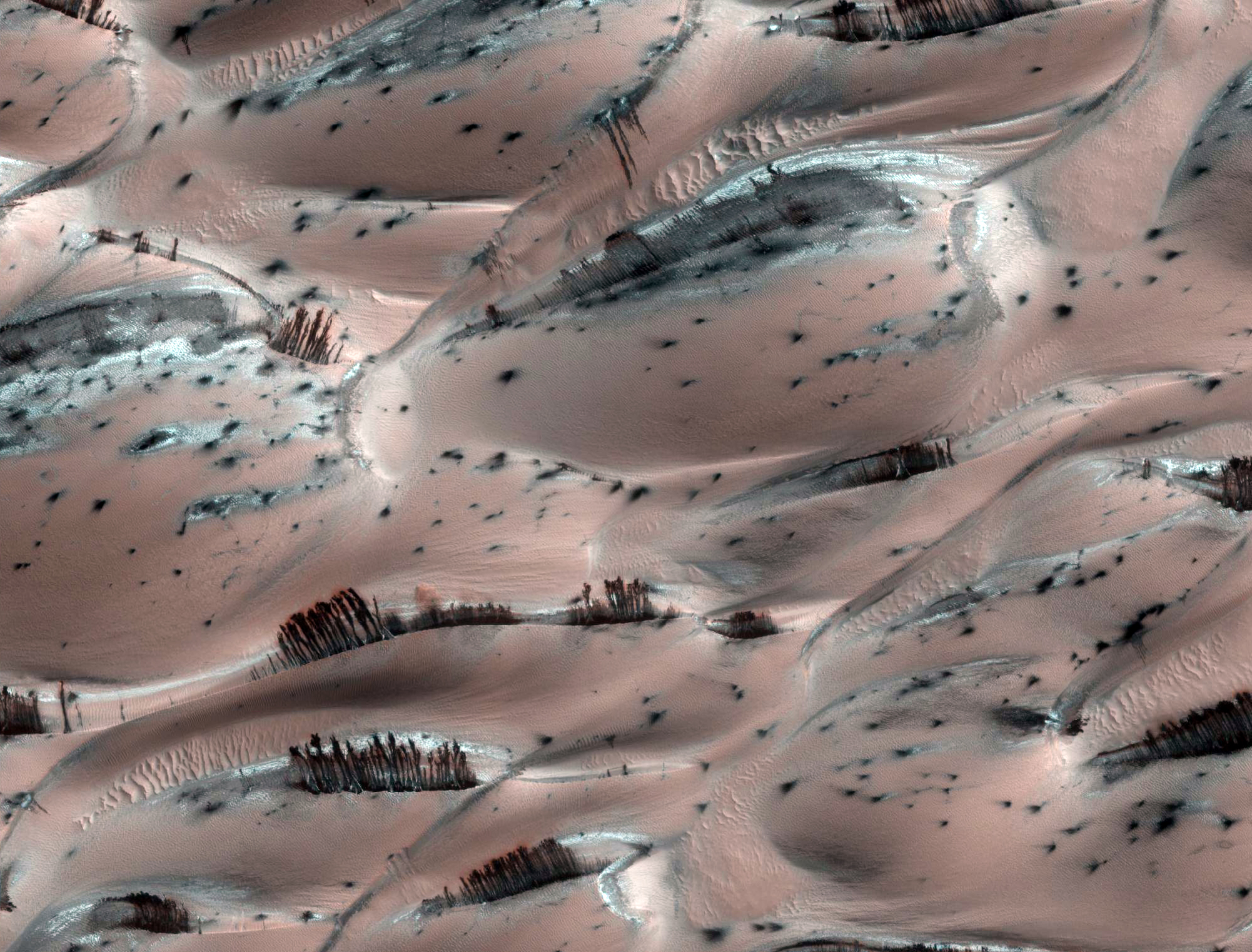
There is a vast region of sand dunes at high northern latitudes on Mars. In the winter, a layer of carbon dioxide ice covers the dunes, and in the spring as the sun warms the ice it evaporates. This is a very active process, and sand dislodged from the crests of the dunes cascades down, forming dark streaks.

In the subimage falling material has kicked up a small cloud of dust. The color of the ice surrounding adjacent streaks of material suggests that dust has settled on the ice at the bottom after similar events.

Also discernible in this subimage are polygonal cracks in the ice on the dunes (the cracks disappear when the ice is gone).

Photo credit: NASA/JPL/University of Arizona

Wednesday, April 28, 2010

McLaughlin Crater Dunes


These sand dunes are located on the floor of McLaughlin Crater.

Photo credit: NASA/JPL/Arizona State University

Note: McLaughlin Crater is located in the Arabia Terra region, just south of the "shore" of Acidalia Planitia.

Radar Map of Buried Martian Ice Adds to Climate Record


Extensive radar mapping of the middle-latitude region of northern Mars shows that thick masses of buried ice are quite common beneath protective coverings of rubble.

The ability of NASA's Mars Reconnaissance Orbiter to continue charting the locations of these hidden glaciers and ice-filled valleys -- first confirmed by radar two years ago -- adds clues about how these deposits may have been left as remnants when regional ice sheets retreated.

The subsurface ice deposits extend for hundreds of kilometers, or miles, in the rugged region called Deuteronilus Mensae, about halfway from the equator to the Martian north pole. Jeffrey Plaut of NASA's Jet Propulsion Laboratory, Pasadena, California, and colleagues prepared a map of the region's confirmed ice for presentation at this week's 41st Lunar and Planetary Science Conference near Houston.

The Shallow Radar instrument on the orbiter has obtained more than 250 observations of the study area, which is about the size of California.

"We have mapped the whole area with a high density of coverage," Plaut said. "These are not isolated features. In this area, the radar is detecting thick subsurface ice in many locations." The common locations are around the bases of mesas and scarps, and confined within valleys or craters.

Plaut said, "The hypothesis is the whole area was covered with an ice sheet during a different climate period, and when the climate dried out, these deposits remained only where they had been covered by a layer of debris protecting the ice from the atmosphere."

The researchers plan to continue the mapping. These buried masses of ice are a significant fraction of the known non-polar ice on Mars. The ice could contain a record of environmental conditions at the time of its deposition and flow, making the ice masses an intriguing possible target for a future mission with digging capability.

Image credit: NASA/JPL-Caltech/ASI/University of Rome/Southwest Research Institute

Tuesday, April 27, 2010

Melas Chasma (II)


This VIS image shows a portion of the floor of Melas Chasma. Wind blown material is located in lows between layered floor materials.

Photo credit: NASA/JPL/Arizona State University

Anaglyph of Arsia Mons' Chain of Pits


The deep pits on the flanks of Arsia Mons have attracted special interest because some are potentially linked to subterranean caverns. Such locations would be protected from the radiation, impacts, and extreme temperature variations seen at the surface of Mars and therefore could be more favorable for life (including future human explorers).

The three pits seen in this area are in a line, suggesting that they all formed in response to the same underground feature. One possibility is a lava tube, but lava tubes tend to have bends and curves. Furthermore, HiRISE shows that there are multiple layers exposed in the walls of the pits. While it is perfectly possible for skylights into lava tubes to cut through multiple lava flows, this is not the most common case (usually they cut through just the top of a single flow). Hence it is more likely that these pits overly a fault system where the ground is being pulled apart.

In places the ground has collapsed into the resulting void, producing these pits. Such faults are expected as the great weight of these giant volcanoes slowly tears them apart. Similar faults and pits are found on many of Earth's volcanoes, with Kilauea Volcano on Hawaii being perhaps the best studied example.

Photo credit: NASA/JPL/University of Arizona

Note: For another photograph and more information about these same pits on Arsia Mons, see Chain of Pits on Arsia Mons.

Monday, April 26, 2010

Kasei Valles


This VIS image shows secondary channeling on a terrace of the huge Kasei Valles outflow system.

Photo credit: NASA/JPL/Arizona State University

Icy Craters on Mars


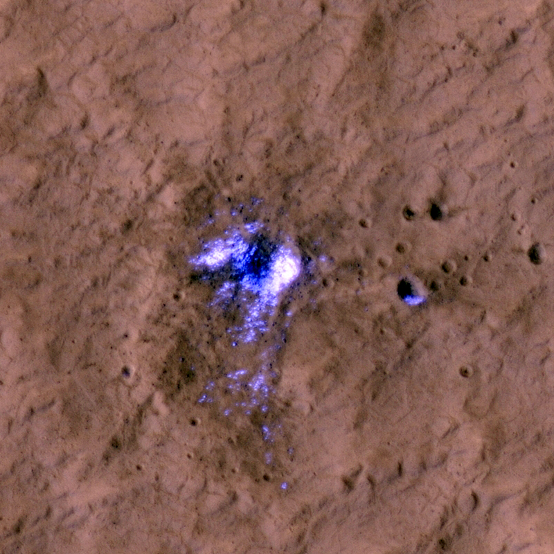
Newly formed impact craters have been discovered on Mars over the past several years. When craters form over dusty regions the impact blast blows the bright dust off the terrain over a wide area, leaving a dark spot.

These large dark spots are visible to the Context Camera (CTX) and the Context Camera team reports their discovery to the HiRISE team. HiRISE has sufficient resolution to see not only the dark blast zone, but also the much smaller crater that formed it. One of these craters, with its dark blast zone, is visible in the first subimage. The blast zone is almost 800 meters (half a mile) across. The crater itself is just over 20 meters (66 feet) across and is shown in the second subimage.

This crater is one of a special group that have excavated down to buried ice. This ice gets thrown out of the crater onto the surrounding terrain. Although buried ice is common over about half the Martian surface, we can only easily discover craters in dusty regions. The overlap between areas that both have buried ice and surface dust is unfortunately small. So even though we have discovered over 100 new impact craters we have only discovered 7 new craters that expose buried ice.

When craters excavate this buried ice it tells us something about the extent and depth of buried ice on Mars (controlled by climate); this information is used by planetary scientists to figure out what the recent climate of Mars was like. It has also been a surprise that this ice is so clean. Scientists expected this buried ice to be a mixture of ice and dirt; instead this ice seems to have formed in pure lenses. Yet another surprise that Mars had in store for us!

Photo credit: NASA/JPL/University of Arizona

Note: This crater is located in the Phlegra Montes region.

Sunday, April 25, 2010

Melas Chasma


Melas Chasma is the central portion of Valles Marineris. This VIS image shows a small portion of the floor of Melas Chasma, including layered deposits and wind eroded and deposited materials.

Photo credit: NASA/JPL/Arizona State University

Chain of Pits on Arsia Mons


The lower flanks of Arsia Mons, one of the giant volcanoes on Mars, is riddled with pits of various sizes. These have been of great interest to a number of researchers because they have the potential to be openings into underground caverns.

Such caverns have some potential for holding ice and offer protection from radiation and small meteorites. These are good things if one is looking for a safe place for current life on Mars or future human life.

However, this image shows some of the pitfalls of such hopes. Most of these pits are largely filled with rubble and dust that hide any potential links to larger underground areas. Furthermore, the entrances are steep and rocky, making them difficult areas to traverse. They would be a very exciting, if not safe, place to visit!

Photo credit: NASA/JPL/University of Arizona

Note: This pit is located on the northwest flank of Arsia Mons.

Saturday, April 24, 2010

Memnonia Sulci


Wind is one of a handful of active processes on Mars today. This VIS image of Memnonia Sulci demonstrates the power of wind in eroding and shaping the surface.

Photo credit: NASA/JPL/Arizona State University

Note: This image was taken in Memnonia Sulci, which is located in the Memnonia Quadrangle.

Cluster of Secondary Impact Craters


This observation was taken to see if the cluster of pits were formed by the interaction of hot lava with water. Such pits and cones have been found in this region, most likely because there was significant ice in the ground when a large lava flow inundated the area.

However, in this case, HiRISE reveals that the circular features are a mass of impact craters (note that the word "crater" is used by geologists for holes formed by volcanic, impact, and other geologic processes). The tight clustering of these craters is unusual. The most likely explanation is that they were formed by a clump of material thrown out from a larger impact crater nearby. As such, they are called "secondary" craters with the larger source crater called a "primary". This HiRISE image covers too small an area to identify the primary.

Photo credit: NASA/JPL/University of Arizona

Note: This photo was taken in the Tartarus Montes/Phlegra Dorsa region of Elysium Planitia.

Friday, April 23, 2010

Terra Cimmeria Dunes


This VIS image of Terra Cimmeria shows channeling and dunes near Herschel Crater.

Photo credit: NASA/JPL/Arizona State University

Mound of South Polar Layered Deposits


The south polar layered deposits are a stack of layered ice up to 3000 meters (9800 feet) thick which is similar to terrestrial ice sheets. In places, this stack extends up to 1100 kilometers (680 miles) from the pole and many of the impact craters surrounding this ice-sheet appear to be filled with mounds of similar icy material and also sand dunes.

This image shows the material within one of these near-polar craters. The crater is about 44 kilometers (27 miles) across and contains a mound of material about 23 kilometers (14 miles) across and 300 meters (1000 feet) thick on its northern (south facing) wall. The dark material at the top (north) of the image shows the northern wall of the crater, the bright material that begins near the image top and extends toward the bottom is the surface of the mound.

This surface is covered with sand dunes that appear bright as they are still covered by seasonal carbon dioxide frost. Smaller dunes and ripples can be seen on the surfaces of the larger linear dunes. In the low lying areas between dunes, one can see a network of cracks that are reminiscent of the surface of the polar layered deposits, indicating that this mound is probably mostly ice with a thinner and incomplete covering of dunes.

The dark spots in the frost cover are characteristic of how this terrain defrosts, and are commonly observed in these locations during this season.

Photo credit: NASA/JPL/University of Arizona

Note: This photo is of the Terra Cimmeria region, and is located near the Ulyxis Rupes scarp and Jeans Crater, both of which are to the east.

Thursday, April 22, 2010

Multiple Channels in Warrego Valles


The image shows an area in the Warrego Valles region. It was collected July 6, 2003 during the northern summer season. The local time is 5 p.m. The image shows multiple channels dissecting the terrain.

Photo credit: NASA/JPL/Arizona State University

Headwater Region of Warrego Valles


One of the most well-known valley networks on Mars is Warrego Valles. Located along the southern boundary of the Thaumasia Plateau in the southern highlands, images of these valley systems are often used in textbooks or online as evidence for a more Earth-like climate on early Mars.

At least before the HiRISE era, whenever a single image illustrating "water on Mars" was needed, a Viking-era image of Warrego answered the call. Despite its fame, the origin of the Warrego valley networks has never been fully understood.

At first glance, these ancient (several billion years old) valley systems seem similar to erosional networks on Earth, but they are simpler and not as finely integrated. In addition, they are only located in one area on the plateau boundary. Valleys have not formed all along the plateau boundary as might be expected from rainfall (Gulick, 2001, Geomorphology, pgs. 241-268). Nevertheless many have argued that these features attest to an ancient warmer, wetter time of Mars' geological history. To better understand the Warrego valleys, HiRISE imaged the headwater regions of one of the tributaries.

Seen at high resolution the system appears more complex than implied by the much lower resolution Viking-era images. The valley floor — as well as the floors of nearby small craters — is covered by an enigmatic rough, angular, blocky textured material that seems to be contained in a finer-grained material. This rough textured material might also be the result of ice evaporating from the subsurface.

At any rate, at HiRISE resolution, there is little sign of fluvial bedforms, like channel bars, from the original erosive event that carved the valleys. Given the age of these valleys, clues to its origin may long since have been obscured by subsequent geologic processes. Without such geologic clues we can add little more to the previous speculation about what might have carved these features originally. In this case, the high resolution images provided by HiRISE inform us that we have much more to learn about some of the best known landforms on Mars.

Photo credit: NASA/JPL/University of Arizona

Wednesday, April 21, 2010

North Polar Dunes


This VIS image of dunes in the north polar region was collected in early spring. Frost still covers the dunes.

Photo credit: NASA/JPL/Arizona State University

Note: The dunes in this photo are called barchan dunes, and are pushed along by the wind in the direction the two horns on the sides point toward (in this photo, to the northeast). For a similar photo, see Barchan Dune Field in Arkhangelsky Crater.

Rim of Bopolu Crater, by Opportunity


NASA's Mars Exploration Rover used its panoramic camera to record this view of the rim of a crater about 65 kilometers (40 miles) in the distance, on the southwestern horizon. This crater, Bopolu, is about 19 kilometers (12 miles) in diameter.

The image was taken during the 2,179th Martian day, or sol, of Opportunity's mission on Mars (March 11, 2010), two days after the rover drove southward away from Concepción Crater, site of several weeks of investigation.

Opportunity's long-term destination is Endeavour Crater, to the southeast and closer than Bopolu. The intended route heads south before turning east in order to bypass potentially hazardous sand ripples to the east, larger than the ripples in the foreground of this image.

This approximately true-color view combines three exposures taken through filters admitting wavelengths of 750 nanometers, 530 nanometers and 480 nanometers.

Photo credit: NASA/JPL-Caltech/Cornell University