Sunday, February 28, 2010

Mars Express to make closest ever approach to Phobos

On 3 March 2010 Mars Express will make its closest ever approach to Phobos, the larger of the two Martian moons. During a series of flybys, spanning six weeks, all seven instruments onboard Mars Express will be utilised to study Phobos. The close approach provides a first opportunity to perform a unique gravity experiment that may reveal the distribution of mass within this intriguing moon.


ESA's Mars Express spacecraft orbits the Red Planet in a highly elliptical, polar orbit that brings it close to Phobos every five months. It is the only spacecraft, currently in orbit around Mars, whose orbit reaches far enough away from the planet to provide a close-up view of Phobos. Over the course of twelve flybys, taking place between 16 February and 26 March 2010, Mars Express will pass within 1400 km of the surface of Phobos. The Mars orbiter will make its closest ever approach to Phobos- just 50 km above the surface - on 3 March 2010.

The suite of seven experiments onboard Mars Express are primarily used to study the atmosphere, surface and subsurface of the Red Planet. These science instruments can also be used to investigate Phobos. During this current series of flybys all Mars Express instruments will be used to study Phobos, taking advantage of not only the close approach to the moon but also, for the gravity experiment during the closest flyby, the proximity of Mars to the Earth.

Phobos – a moon of unknown origin
Phobos, the larger of the two Martian moons, remains one of the few objects in the Solar System whose location cannot be easily explained. By studying Phobos with the Mars Express instruments scientists are hoping to contribute to the understanding of the moon's nature and origin. Phobos (and Deimos) could be captured asteroids – early measurements of the composition of both moons were compatible with this idea – or they could have formed from material that was ejected following a large collision with Mars. Additional theories are that the moons could be survival planetisimals, or formed from the break-up of a moon that was created early in the formation of the Solar System. Knowing how the mass is distributed within Phobos is an important step in understanding the interior of the moon and this in turn will provide crucial insight into the moon’s origin.

Studying Phobos close-up – unique science
At a distance of just 50 km above the surface of Phobos Mars Express will make the most precise measurements to date of the moon's gravity field using the X-band (8.4 GigaHertz) channel of the Mars Radio Science (MaRS) instrument. This instrument relies on the observation of the phase, amplitude, polarisation and propagation times of radio signals transmitted from the spacecraft and received at ground station antennas on Earth. The radio signals are affected by the medium through which the signals propagate, by the gravitational influence of Mars on the spacecraft and finally by the performance of the various systems involved both on the spacecraft and on ground. In addition, during this series of close flybys, the gravitational attraction of Phobos will slightly disturb the trajectory of the spacecraft. The difference between predicted trajectory (without Phobos) and the actually observed trajectory will lead to the determination of the forces acting on the spacecraft and from them the gravity field of the moon. To make these measurements, the spacecraft operates in two-way link mode with an X-band uplink and downlink.

This current series of flybys happen to occur when the orbits of Earth and Mars bring them close together which means that Mars Express will be ideally positioned to maximize the signal-to-noise ratio of the two-way X-band radio-link. NASA’s Deep Space Network (DSN) 70 metre radio station at Robledo, Spain, will track the radio signal from Mars Express and will pick up the subtle changes in the signal due to the doppler effect as the gravity of Phobos affects the spacecraft's velocity. In addition, the ESA Cebreros station will also be listening to the signal.

Mapping the mass distribution of Phobos
Analysis of Mars Express data will provide key coefficients of the gravity field. The most important coefficient, the mass of Phobos, has been determined from previous flybys at higher altitudes, but it does not provide any information about how the mass is distributed. Calculation of the density of Phobos, using the mass and volume, gives a value too low to be consistent with a solid, non-porous body, which has led to speculation about the composition of the moon and about how its mass is distributed.

Measurement of the gravity field coefficients from a lower altitude, as will be achieved during this series of flybys, will provide increased accuracy of the mass and allow the subsequent, smaller coefficients, such as the J2 coefficient, to be determined for the first time. To determine the mass distribution of Phobos these coefficients are required along with the libration, a measure of how Phobos rotates – this has already been determined from Mars Express HRSC images. Knowledge of these various parameters allows the three principle moments of inertia to be derived - these in turn describe the mass distribution of Phobos. Models of Phobos' interior are being developed and will be tested against the findings of the current and future close flybys.

Studying Phobos close-up – continuing investigation
In addition to the new science performed during the gravity experiment, this series of flybys will see Mars Express build on knowledge gained from previous flybys. HRSC data obtained during previous flybys has led to the development of a new topographical atlas of Phobos (see M. Wählisch et al. (2009) for further details and the Phobos atlas website). On-going investigations include: improving the accuracy of the location of Phobos (see J. Oberst et al. (2006), V. Lainey et al. (2007), K. Willner et al. (2008), P. Rosenblatt et al. (2008)) and therefore knowledge of its constantly changing orbit as it spirals slowly towards Mars; measurements of the surface to determine its composition (see B. Gondet et al. (2008), S. Perrier et al. (2004)), study of the origin of grooves [pdf] (see J. Murray et al. (2006)), shape (see K. Willner et al. (2010)) and sub-surface properties; as well as studying how the surface interacts with the solar wind.

Mars Express data will provide an important contribution to understanding the nature and origin of Phobos but this alone will not provide a definitive answer. Further exploration is required, and in 2011 the Russian Phobos-Grunt (Phobos-Soil) mission is scheduled to launch to retrieve a sample from Phobos to return for study on Earth. Images taken by the Mars Express HRSC instrument during this series of flybys will be used to support the final selection of the Phobos-Grunt landing site.

Credits:
Digital terrain model of Phobos derived from HRSC data (top), M. Wählisch et al. (2009)
Orbits of Phobos and Mars Express (bottom), ESA

For a very nice animation of Phobos (that, unfortunately, I'm not able to upload for this blog post), see A Complete View of Phobos.

Saturday, February 27, 2010

Central Deposits in Pasteur Crater

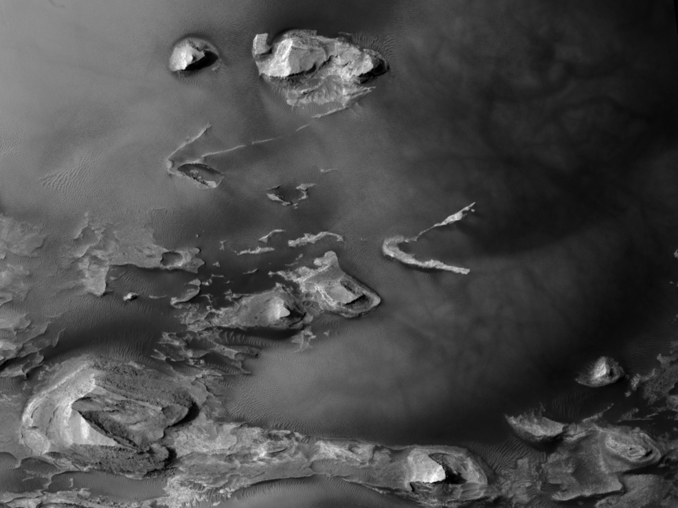
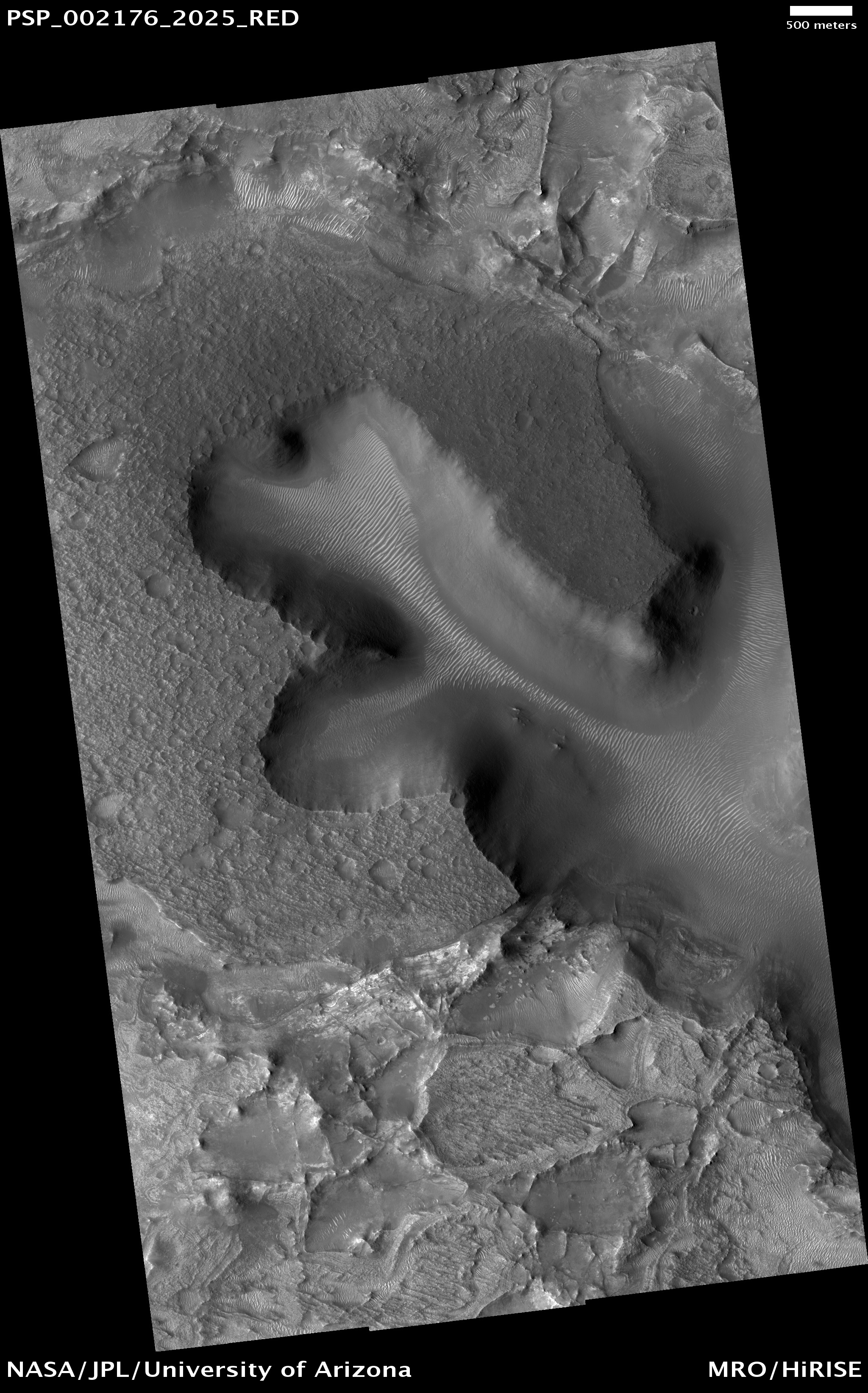
This observation shows a portion of the central sedimentary deposits in Pasteur Crater [located in Arabia Terra].

The deposits in this image [are] now being eroded into knobs and ridges. The erosion is probably dominated by wind, as most of the ridges are parallel. This is common in wind-eroded features, with the ridges generally aligned with the prevailing wind.

At high resolution, layering is revealed in many of the knobs and outcrops. The horizontal layers indicate that the material was deposited uniformly over a broad area. Possible origins include volcanic airfall or lacustrine (lake) deposits. After deposition, the rock in this area has been fractured and faulted, forming a diverse array of cracks.

The mottled appearance of much of the image is caused by dark, featureless patches which may be wind-blown dust. These have interacted with lighter-toned ridges and ripples which are probably also formed by aeolian (wind) processes. In places, the dark patches partially cover the ripples, indicating that they have moved more recently, but they must be thin because the ripples frequently stand above surrounding dark material.

The ripples exhibit multiple interacting orientations in some places, producing networks of small ridges which reflect movement in winds from several directions.
Photo Credits: NASA/JPL/University of Arizona

Friday, February 26, 2010

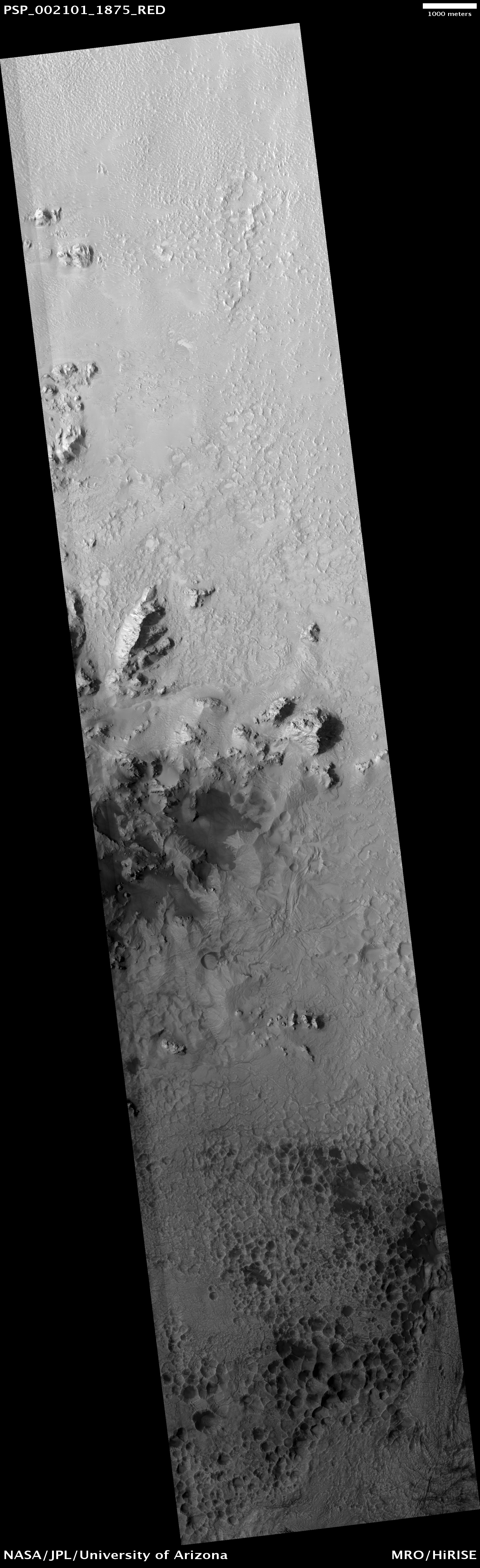
A Field of Secondary Craters

This observation shows a secondary crater field, which form when material ejected from a larger impact event impacts the Martian surface. One impact event, depending on the size of the impactor, can form hundreds of millions of secondary craters at essentially the same time.

Primary craters (those created directly from an impactor from space) can be the same size as secondary craters, which makes dating surfaces based on the number of accumulated craters difficult to near-impossible. Secondary craters are distinguished from primaries based on their morphologies. They are sometimes irregularly shaped, as seen in this image, because they form at relatively low velocities. The velocity of the impactor determines a crater’s size, shape, and depth, with lower energy impacts forming shallow, less-developed craters and higher energy impacts forming deeper, more regular craters.

Secondary craters often occur in clusters, as seen here, as a piece of ejecta breaks up before hitting the surface. Primary craters form at random locations globally. Secondary clusters are more likely to be found in groups because of their formation mechanism.
Note: The craters in this photo are located in the southwestern rim of Utopia Planitia (31.1° North, 89.7° East), in the Casius Quadrangle.

Photo Credit: NASA/JPL/University of Arizona

Thursday, February 25, 2010

Mojave Crater: The Rosetta Stone of Martian Craters?

This Digital Terrain Model (DTM) covers the northwestern portion of the approximately 60 kilometer diameter Mojave Crater, centered at 327.0 degrees East, 7.5 degrees North in Xanthe Terra on Mars.

The perspective views subimage 1 [the black-and-white image above] and subimage 2 shows the entire HiRISE image covering portions of the crater’s northwestern wall-terraces, rim and ejecta blanket (see subimage 3 for context). Subimage 1 is viewed from the southeast and highlights the crater interior. Subimage 2 is viewed from the northwest and highlights the crater rim and ejecta blanket. The vertical exaggeration for these images are set to 3x (meaning that features appear to be 3x taller than they are wide).

One of the most interesting features in Mojave are the “pitted ponds” that appear to be “backed-up” behind massive wall-terrace blocks of bedrock. Pitted materials are currently recognized in hundreds of fresh and well-preserved Martian craters, and are thought to represent impact melt bodies that were captured behind the wall-terraces as they faulted off the rim and into the crater interior. With the exception of the dense population of pits, these “ponds” are quite similar to impact melt ponds observed on the wall-terraces of lunar craters (see the Kaguya image gallery).

The DTM shows terrain spanning -4803.65 meters to -2744.87 meters (-3 miles to -1.7 miles) with respect to the Martian datum (just over 2 kilometers [1.3 miles] from the lowest to highest points; see color altimetry image [above]). Based on observations and modeling of fresh craters, a crater the size of Mojave should be approximately 2,595 meters (1.62 miles) deep in its most pristine state. The DTM here does not show the lowest point in the crater, but still demonstrates nicely that Mojave has minimal infilling or erosion, and is very close to its pristine state – estimates from other datasets indicate that Mojave is approximately 2,604 meters (1.63 miles) deep. A survey of Mojave’s features indicates that there are very few overprinting craters on them.

A statistical analysis of Mojave’s overprinting craters further indicates the youthfulness of Mojave, as models indicate the crater may be as “young” as approximately 10 million years old – well within the Amazonian Era, and indeed a very young Martian crater for its size.

Mojave no doubt gives us a glimpse of what a very large complex crater should look like on Mars; and perhaps in a sense, it is a “Rosetta Stone” of craters, given that it’s so “fresh” and most others – especially this size – have been affected by erosion, sedimentary infilling and overprinting by other geologic processes. Such craters like Mojave, especially when accounting for size, location and target properties, are one-of-a-kind ... , but give tremendous insight into the impact process (e.g., ejecta, melt-generation and deposition, etc.).

Mojave’s fans and channels are most intriguing, and hint that impacts such as Mojave may have unleashed water/water-ice from the subsurface to flow across the surface and, perhaps, condense as rain or snow for only a brief period of Martian time. This further suggests that early climate on Mars could have been heavily influenced by its most intense bombardment when many Mojave-sized craters (and far larger) were more common, approximately 3.9 billion years ago.
Credit: NASA/JPL/University of Arizona/USGS

Wednesday, February 24, 2010

Changes at the Site of a New Impact Cluster

Nineteen new impact sites were discovered by the Mars Orbital Camera on the Mars Global Surveyor, and HiRISE has re-imaged these sites to learn more about them, including detection of many smaller craters since the objects often break up in the atmosphere and make clusters of craters.

The biggest cluster--shown here--with over 1,000 craters, formed between September 2005 and February 2006, over the dusty region between Ascraeus and Pavonis Mons, giant shield volcanoes. We have imaged some of these new impact sites multiple times to look for changes, which provides information on aeolian (wind-driven) processes.

Many of these impact sites are remarkably unchanged over several years time, but the site shown here has changed dramatically. In the subimage [above right] are cutouts of the impact cluster from PSP_003172_1870 (top), PSP_007431_1870 (middle), and this newest image (bottom). Blowing winds through the pass between shield volcanoes has darkened some regions and brightened others, probably largely by removing and depositing dust.
Photo Credit: NASA/JPL/University of Arizona

Tuesday, February 23, 2010

Evidence of Multiple Episodes of Gully Formation

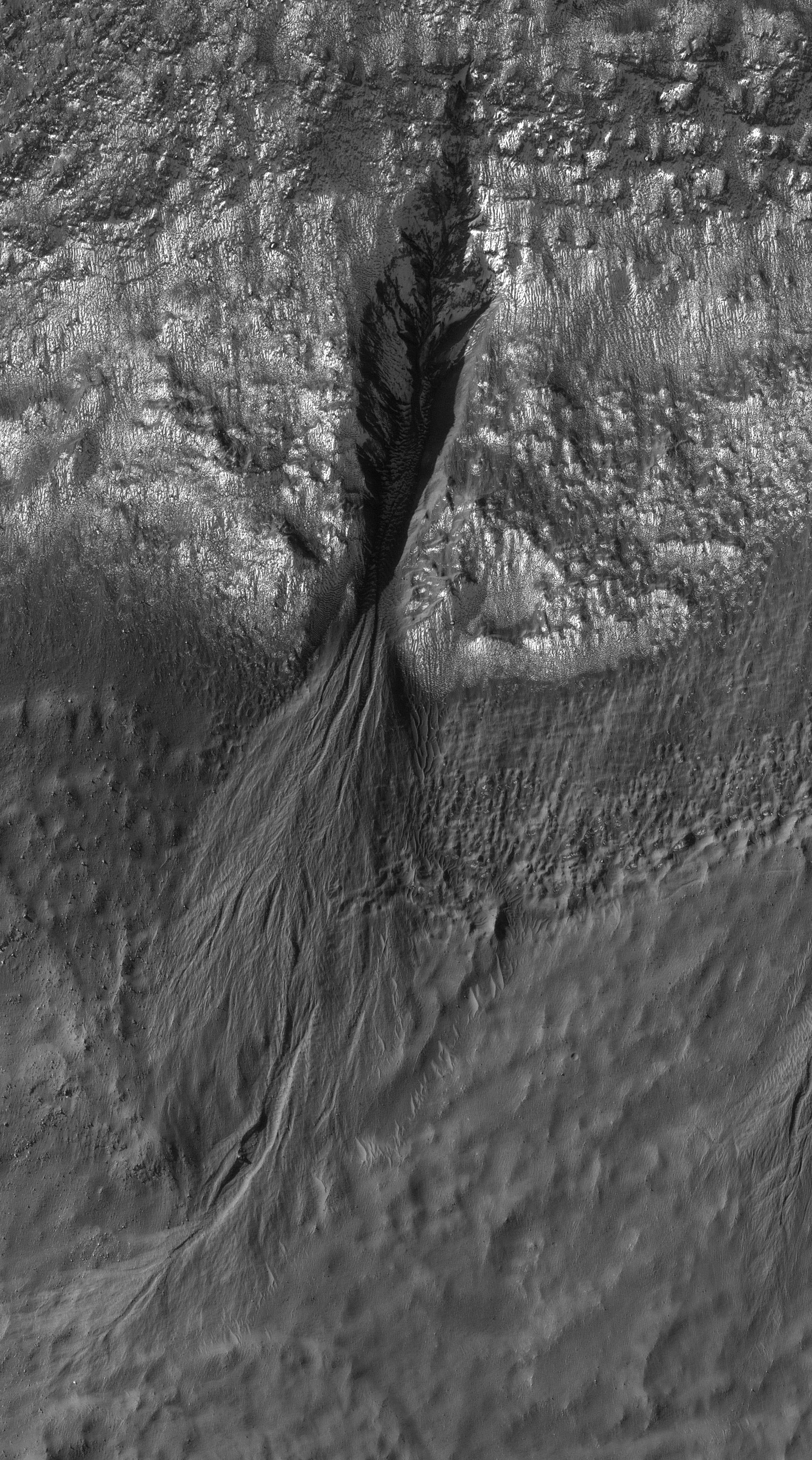
This observation shows gullies in a crater in Terra Sirenum. The gullies unusually emanate from different elevations along the crater wall. Several of the gullies are extremely developed and incised, while others have very narrow, shallow channels.

Many of the gullies appear to have extensive debris aprons, but that could be deceiving. Based on their surroundings, the topography underlying the debris aprons is likely not flat or gently sloping. This might cause the debris apron material to cover a wider surface area, without being as large of a volume as it might appear visually, than it otherwise would.

The subimage shows a gully with many channels. Several of the channels overlap or are overlapped by debris aprons suggesting that multiple flow episodes occurred here. In particular, there is a large channel that sticks out from underneath the main debris apron with a debris apron of its own. If this channel originated where the alcove currently is, then it is possible that the past flow contained more liquid and that the source of liquid to form the gullies in this region is now available in smaller amounts for an unknown reason.
Photo Credit: NASA/JPL/University of Arizona

Monday, February 22, 2010

Crater Floor in Arabia Terra Region

This observation shows a northwestern portion of the floor of a crater in the Arabia Terra region of Mars.

In the subimage, several light-toned layered outcrops are visible, surrounded by dunes of varying sizes. The outcrops exhibit multiple alternating light and dark layers with extensive fracturing and small fault offsets. The outcrops represent the eroded remains of sedimentary rocks that formed from sediments once deposited within the crater. Possible origins for the sediments include windblown debris, volcanic ash falling from the sky, or sediments that accumulated in a lake on the crater floor.

The dark filamentary streaks in the right half of the full image were most likely created by the disruption and/or removal of thin surface coatings of dust by the passage of a dust devil. Streak patterns such as these have been found to change over periods of several months to an Earth year, suggesting that the ones seen here probably formed relatively recently.
Photo Credit: NASA/JPL/University of Arizona

Sunday, February 21, 2010

Sinuous Ridges Near Aeolis Mensae


This observation covers part of a fan-shaped deposit of material in the Aeolis Mensae region of Mars.

The dominant surface texture is a series of parallel linear ridges. In addition, there are several sinuous, flat-topped ridges. The sinuous ridges do not follow the trend of the linear ridges, and various intersecting relations are observed.

The southernmost sinuous features in this image are partially buried by linear ridge material, while in the northern part of the image they appear to stand above it. This could indicate that the linear unit has been more eroded in the north than the south, but may also be due to a more complex geological history in which different sinuous ridges formed at different times. In the northeast part of the image one sinuous ridge appears superposed on another, supporting this hypothesis.

The linear ridges may be yardangs. Yardangs form when material is eroded by wind, producing elongated features aligned with the prevailing wind. Many of the ridges expose layers and appear to have broken into boulders. Layering indicates multiple episodes or pulses of deposition, while the occurrence of boulders shows that the material has been consolidated to some degree.

The sinuous ridges could be former stream channels outcropping in inverted relief, where a formerly low-lying feature is now relatively high-standing. This occurs when the stream channel is more resistant to erosion that the surroundings, either due to cementation by water or to the presence of large rocks which are not easily eroded.

In this case, the sinuous ridges contain few boulders resolvable by HiRISE, generally appearing uniform and smooth. They also contain fractures which in places cut across the entire ridge. Both of these observations are consistent with cementation of former channel floors.
Photo Credit: NASA/JPL/University of Arizona

Saturday, February 20, 2010

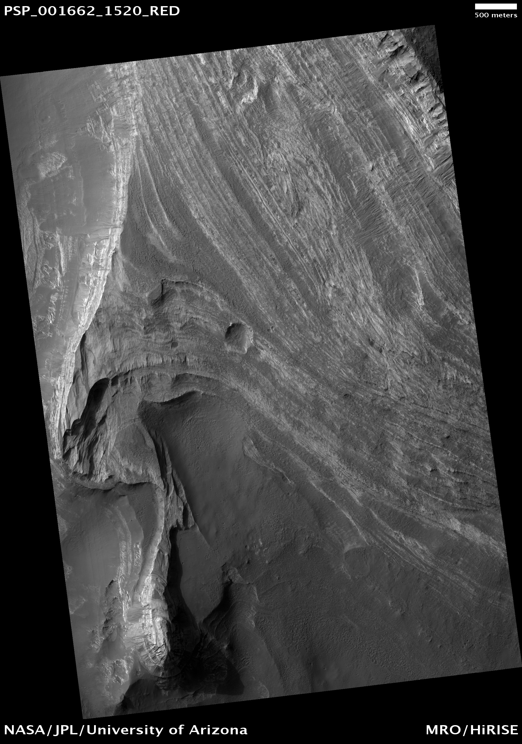
Layers in Olympus Mons Basal Scarp


This observation shows a small portion of the scarp (cliff) that surrounds the largest volcano in the solar system, Olympus Mons.

The scarp is of unknown origin. It may have formed from faulting or other tectonic processes resulting from the heavy loading of the Martian crust in this location. The bottom of the image shows the cratered flanks of Olympus Mons.

Olympus Mons is a large shield volcano, like the Hawaiian volcanoes on Earth. Shield volcanoes have very shallow slopes and gentle eruptions. The Hawaiian volcanoes form when a plate of crust moves over a hot spot. The hot spot produces magma that gradually forms the volcanoes. Since Earth has plate tectonics, the crustal plate moves over the hot spot producing a chain of volcanoes.

Mars does not have plate tectonics, which causes the magma to build a volcano in one location making Olympus Mons so large.

Photo Credit: NASA/JPL/University of Arizona

Friday, February 19, 2010

Eroding Layers in an Impact Crater


This image shows a stack of layers on the floor of an impact crater roughly 30 kilometers across, located in the Iapygia Quadrangle (MC-21) of Mars. Many of the layers appear to be extremely thin, and barely resolved.

In broad view, it is clear that the deposit is eroding into a series of ridges, likely due to the wind. Below the ridges, additional dark-toned layered deposits crop out. These exhibit a variety of textures, some of which may be due to transport of material.

The light ridges are often capped by thin dark layers, and similar layers are exposed on the flanks of the ridges. These layers are likely harder than the rest of the material, and so armor the surface against erosion. They are shedding boulders which roll down the slope, as shown in the subimage. Although these cap layers are relatively resistant, the boulders do not seem to accumulate at the base of the slope, so it is likely that they also disintegrate relatively quickly.

The subimage itself is 250 meters wide. The light is from the left. Boulders are visible on the slopes of the ridges along with thin dark layers including the cap layer, but they are absent on the spurs where the resistant cover has been eroded. This demonstrates that the boulders come only from the dark layers, and are not embedded in the rest of the deposit.
Photo Credit: NASA/JPL/University of Arizona

Thursday, February 18, 2010

Slope Streaks in Terra Sabaea


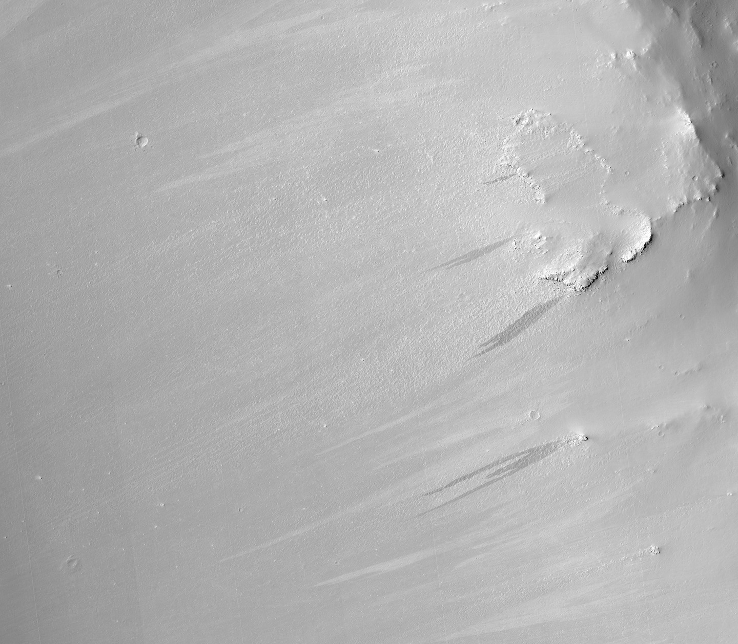
This observation shows the rim of a crater in the region of Terra Sabaea in the northern hemisphere of Mars.

The subimage is a close-up view of the crater rim revealing dark and light-toned slope streaks. Slope streak formation is among the few known processes currently active on Mars. While their mechanism of formation and triggering is debated, they are most commonly believed to form by downslope movement of extremely dry sand or very fine-grained dust in an almost fluidlike manner (analogous to a terrestrial snow avalanche) exposing darker underlying material.

Other ideas include the triggering of slope streak formation by possible concentrations of near-surface ice or scouring of the surface by running water from aquifers intercepting slope faces, spring discharge (perhaps brines), and/or hydrothermal activity.

Several of the slope streaks in this subimage, particularly the three longest darker streaks, show evidence that downslope movement is being diverted around obstacles such as large boulders. Several streaks also appear to originate at boulders or clumps of rocky material.

In general, the slope streaks do not have large deposits of displaced material at their downslope ends and do not run out onto the crater floor suggesting that they have little reserve kinetic energy. The darkest slope streaks are youngest and can be seen to cross cut and superpose older and lighter-toned streaks. The lighter-toned streaks are believed to be dark streaks that have lightened with time as new dust is deposited on their surface.
Photo Credit:  NASA/JPL/University of Arizona

Wednesday, February 17, 2010

Exhumed Layers Near the Nili Fossae


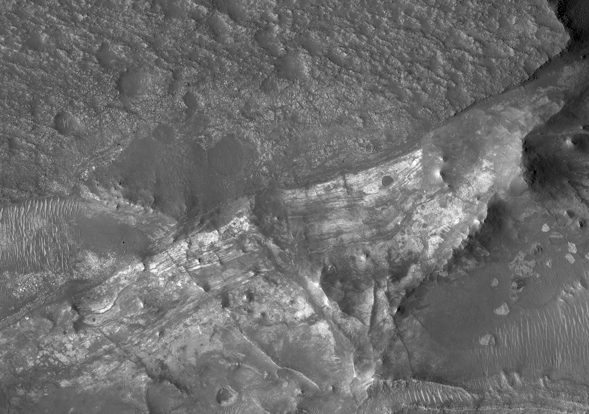
This subimage shows (near center) densely fractured light-toned rock in the vicinity of the Nili Fossae. The light-toned material is finely layered; these layers are visible in cross-section along a scarp face at the bottom of the image.

At full resolution, the light-toned layered materials resemble those seen in other HiRISE images of Nili Fossae and its surroundings, some of which have been identified on the basis of their infrared spectra (by OMEGA and CRISM) as containing phyllosilicates (clays), which require the presence of water to form. These layers likely formed very early in Martian history, but must have been rapidly buried due to the lack of overprinting impact craters.

Presently, the light-toned materials are being exhumed as the overlying material is eroded away by wind.

Additionally, the light-toned layers are overlain by a darker, densely pitted, rubbly layer. The areal extent of this darker layer, which has no apparent internal layering, is visible in the full image. The dark layer may represent lava flows, possibly extruded from the Nili Fossae fissures or from the Syrtis Major volcano, 1000 kilometers (620 miles) to the southwest.

In the full image, the large valleys cutting into the dark material and its underlying layers may have formed by groundwater seepage and erosion, or by tectonic processes related to the opening of the Nili Fossae fissure system, to which the valleys connect just southeast of this image.

South of the large area capped by dark material is a complex terrain of irregularly shaped pits and mesas, some of which are also capped by dark, pitted rock. The lighter, layered, densely fractured material is well exposed here. The pits are filled with relatively dark-toned, fine-grained material, and lighter wind-blown ripples are also present in some cases. Large boulder-sized fragments of light-toned rock are also visible in some pits, especially near the eroding scarp face highlighted in the sub-image above.

Photo Credit: NASA/JPL/University of Arizona

Tuesday, February 16, 2010

Debris Flow Near Hale Crater


Channels are found all around Hale Crater. The largest channels were there before the formation of Hale, such as Uzboi Vallis.

The impact that created Hale Crater smashed directly into Uzboi Vallis, a very large channel thought to have periodically transported hundreds of thousands of cubic meters of water per second. Another nearby channel is Nirgal Vallis, an approximately 700 kilometer (430 miles)-long channel interpreted to have formed from groundwater sapping. Nirgal Vallis is about 300 kilometers (190 miles) from Hale.

Other, smaller channels also radiate from Hale. The relationship between the channels and the ejecta from Hale Crater strongly suggests the Hale-forming impact event created, or at least heavily modified, the channels.

One of the types of channels thought to have been formed at the same time as Hale Crater is a channel with raised margins. These channels are relatively short (less than 5 kilometers, or 3 miles) and less than 0.5 kilometers (0.3 miles) wide. They are found on the slope break at the very edge of the northern rim of Argyre Basin, which opens to the bottom left of this image. We interpret these channels to be the result of debris flows.

Photo Credit: NASA/JPL/University of Arizona

Sunday, February 7, 2010

Frost-Covered Dunes in the North Polar Region


This image shows dunes on the northern plains of Mars, and appears similar to images taken when the surface was covered by frost.

However, CRISM spectra taken at the same time do not show evidence for either water or carbon dioxide frost here. Possibly, and consistent with the CRISM spectra, this area is covered by dust, obscuring the dark material that is typically present in dunes of this type.

The orientation of the dunes indicates that they were formed by winds blowing generally from upper right to lower left. Ripples on the dunes show that the wind patterns that formed them are more complex, with the dune shapes affecting the wind direction.

It is not known whether these dunes are currently active (being moved by wind today) or have been in this location for a very long time, but if they are indeed covered by dust they cannot have been recently active.

Between the dunes, the underlying surface of the northern plains can be seen. In places, it has been fractured into polygonal blocks, suggesting that water ice is or was present below the surface. Meter-size blocks are also seen in places in this image and elsewhere on the northern plains. The origin of these blocks is not known, but they may be remnants of erosion of material that once covered this region.

Photo Credit: NASA/JPL/University of Arizona

Saturday, February 6, 2010

Layered Deposits in Terby Crater


Terby Crater is a large (approximately 165 kilometer), Noachian-aged crater located on the northern rim of the Hellas impact basin.

Terby hosts a very impressive sequence of predominantly light-toned layered deposits, up to 2.5 kilometers thick that are banked along its northern rim and extend toward the center of the crater.

The full image shows this stack of layered rocks as they are exposed westward facing scarp. The layered sequence consists of many beds that are repetitive, relatively horizontal and laterally continuous on a kilometer scale. Many beds are strongly jointed and fractured and exhibit evidence of small-scale wind scour.

The light-toned layers are typically at least partially covered with dark mantling material that obscures the layers as well as debris and numerous, meter-scale boulders that have cascaded down slope. The processes responsible for formation of these layers remain a mystery, but could include deposition in water, by the wind, or even volcanic activity.

This HiRISE image is a proposed landing site for the Mars Science Laboratory (MSL) in Terby Crater.

Photo Credit: NASA/JPL/University of Arizona

Friday, February 5, 2010

Mojave Crater Floor and Central Uplift


This observation shows a portion of the central uplift structure in Mojave Crater.

Central uplifts are a typical feature of large impact craters on the Earth, the Moon and Mars; craters larger than 6 or 7 kilometers in diameter on Mars typically form this mountain-like peak in the central portion of the crater interior.

This peak consists of rocks originating from several kilometers beneath the pre-impact surface. Mojave has a very prominent central uplift as it has a diameter of 60 kilometers (37 miles). In this image, boulders as large as 15 meters (50 feet) across have been eroded from the massive uplifted rock and have rolled downslope. Fine-grained debris has also collected in the topographic lows, and has been shaped by the wind into dunes and ripples.

Notably absent from this image are the striking drainage channels and alluvial fans that are abundant on the wall-terraces and ejecta of Mojave Crater (see PSP_001415_1875). These features were likely formed by surface runoff of liquid water, which may have been released from the subsurface during the impact event that formed Mojave.

Previously, it had been suggested that a brief, torrential downpour over Mojave Crater delivered the water. However, Mars Orbiter Camera's (MOC) images of Mojave's central uplift have previously shown no evidence for surface runoff, and the higher resolution of this HiRISE image confirms that this part of the crater appears untouched by liquid water.

So the question remains: by what means was the water, in the form of runoff, supplied to Mojave? This question, in addition to several others regarding this phenomenon, are currently being investigated by the HiRISE team and their collaborators.

The full HiRISE image shows that the crater floor south of the central uplift is densely pitted and fractured. These pits, many of which are partially filled with dark sand, lack raised rims and a circular form. This suggests that they are not impact craters. In fact, very few definite impact craters are seen on the floor and walls of Mojave, implying that it is incredibly young and relatively well preserved for a crater of its size.

Photo Credit: NASA/JPL/University of Arizona

Thursday, February 4, 2010

Central Uplifted Region of Crater in Phlegra Dorsa


This image covers part of the central uplifted region of an unnamed crater in Phlegra Dorsa.

This complex crater is approximately 30 kilometers (about 18 miles) in diameter and is centered at 23 N latitude and 176 E longitude. The transition from a simple bowl-shaped crater to a complex crater exhibiting central peaks or pits, flat floors and terraced walls takes place in craters that are larger than about 15 kilometers (about 9 miles) in diameter on Mars. Because the central uplifts of complex craters expose rocks and materials that originated deep below the surface, researchers can use these regions as possible "windows" to view the rocks beneath the surface.

A northeast-southwest linear valley or trough transects this region dividing the uplift in two. This valley, or lineation, may have resulted from processes occurring during the uplift event or subsequent to crater formation. When seen at HiRISE resolution the center of this valley seems to bisect what may be a small (less than a kilometer wide) central pit.

Photo Credit: NASA/JPL/University of Arizona

Friday, January 16, 2009

Discovery of Significant Amounts of Methane on Mars

An interesting article out of NASA today. While I suspect that the methane plumes mentioned are probably of geologic origin, the idea that microorganisms (endoliths) may be living underneath the surface of Mars is not a new one. Certainly the possibility of a biologic origin to some or all of the Martian methane is quite plausible.


Mars today is a world of cold and lonely deserts, apparently without life of any kind, at least on the surface. Indeed it looks like Mars has been cold and dry for billions of years, with an atmosphere so thin, any liquid water on the surface quickly boils away while the sun's ultraviolet radiation scorches the ground.

The situation sounds bleak, but research published today in Science Express reveals new hope for the Red Planet. The first definitive detection of methane in the atmosphere of Mars indicates that Mars is still alive, in either a biologic or geologic sense, according to a team of NASA and university scientists.

"Methane is quickly destroyed in the Martian atmosphere in a variety of ways, so our discovery of substantial plumes of methane in the northern hemisphere of Mars in 2003 indicates some ongoing process is releasing the gas," says lead author Michael Mumma of NASA's Goddard Space Flight Center. "At northern mid-summer, methane is released at a rate comparable to that of the massive hydrocarbon seep at Coal Oil Point in Santa Barbara, California."

Methane -- four atoms of hydrogen bound to a carbon atom -- is the main component of natural gas on Earth. It is of interest to astrobiologists because much of Earth's methane come from living organisms digesting their nutrients. However, life is not required to produce the gas. Other purely geological processes, like oxidation of iron, also release methane. "Right now, we don't have enough information to tell if biology or geology -- or both -- is producing the methane on Mars," said Mumma. "But it does tell us that the planet is still alive, at least in a geologic sense. It's as if Mars is challenging us, saying, hey, find out what this means."

If microscopic Martian life is producing the methane, it likely resides far below the surface, where it's still warm enough for liquid water to exist. Liquid water, as well as energy sources and a supply of carbon, are necessary for all known forms of life.

"On Earth, microorganisms thrive 2 to 3 kilometers (about 1.2 to 1.9 miles) beneath the Witwatersrand basin of South Africa, where natural radioactivity splits water molecules into molecular hydrogen (H2) and oxygen (O). The organisms use the hydrogen for energy. It might be possible for similar organisms to survive for billions of years below the permafrost layer on Mars, where water is liquid, radiation supplies energy, and carbon dioxide provides carbon," says Mumma.

"Gases, like methane, accumulated in such underground zones might be released into the atmosphere if pores or fissures open during the warm seasons, connecting the deep zones to the atmosphere at crater walls or canyons," he says.

"Microbes that produced methane from hydrogen and carbon dioxide were one of the earliest forms of life on Earth," notes Carl Pilcher, Director of the NASA Astrobiology Institute which partially supported the research. "If life ever existed on Mars, it's reasonable to think that its metabolism might have involved making methane from Martian atmospheric carbon dioxide."

However, it is possible a geologic process produced the Martian methane, either now or eons ago. On Earth, the conversion of iron oxide (rust) into the serpentine group of minerals creates methane, and on Mars this process could proceed using water, carbon dioxide, and the planet's internal heat. Another possibility is vulcanism: Although there is no evidence of currently active Martian volcanoes, ancient methane trapped in ice "cages" called clathrates might now be released.

The team found methane in the atmosphere of Mars by carefully observing the planet over several Mars years (and all Martian seasons) using spectrometers attached to telescopes at NASA's Infrared Telescope Facility, run by the University of Hawaii, and the W. M. Keck telescope, both at Mauna Kea, Hawaii.

"We observed and mapped multiple plumes of methane on Mars, one of which released about 19,000 metric tons of methane," says Geronimo Villanueva of the Catholic University of America in Washington, D.C. Villanueva is stationed at NASA Goddard and is co-author of the paper. "The plumes were emitted during the warmer seasons -- spring and summer -- perhaps because the permafrost blocking cracks and fissures vaporized, allowing methane to seep into the Martian air. Curiously, some plumes had water vapor while others did not," he says.

According to the team, the plumes were seen over areas that show evidence of ancient ground ice or flowing water. For example, plumes appeared over northern hemisphere regions such as east of Arabia Terra, the Nili Fossae region, and the south-east quadrant of Syrtis Major, an ancient volcano 1,200 kilometers (about 745 miles) across.

It will take future missions, like NASA's Mars Science Laboratory, to discover the origin of the Martian methane. One way to tell if life is the source of the gas is by measuring isotope ratios. Isotopes are heavier versions of an element; for example, deuterium is a heavier version of hydrogen. In molecules that contain hydrogen, like water and methane, the rare deuterium occasionally replaces a hydrogen atom. Since life prefers to use the lighter isotopes, if the methane has less deuterium than the water released with it on Mars, it's a sign that life is producing the methane.

Whatever future research reveals--biology or geology--one thing is already clear: Mars is not so dead, after all.

Photo Credits: Trent Schindler/NASA (first picture); NASA (second picture) For more pictures and animations, please click here

Tuesday, May 27, 2008

Mars Phoenix Lander Descending

Credit: NASA/JPL-Caltech/University of Arizona

This is a very unique and interesting photograph. There are two versions of this photo available from NASA; one with no background and this one with. I've chosen this particular image because it has a better resolution with respect to seeing all of the spacecraft, the parachute and its cords.

NASA's Mars Phoenix Lander can be seen parachuting down to Mars, in this image captured by the High Resolution Imaging Science Experiment (HiRISE) camera on NASA's Mars Reconnaissance Orbiter. This is the first time that a spacecraft has imaged the final descent of another spacecraft onto a planetary body.

From a distance of about 310 kilometers (193 miles) above the surface of the Red Planet, Mars Reconnaissance Orbiter pointed its HiRISE obliquely toward Phoenix shortly after it opened its parachute while descending through the Martian atmosphere. The image reveals an apparent 10-meter-wide (30-foot-wide) parachute fully inflated. The bright pixels below the parachute show a dangling Phoenix. The image faintly detects the chords attaching the backshell and parachute. The surroundings look dark, but corresponds to the fully illuminated Martian surface, which is much darker than the parachute and backshell.

Phoenix released its parachute at an altitude of about 12.6 kilometers (7.8 miles) and a velocity of 1.7 times the speed of sound.

The HiRISE, acquired this image on May 25, 2008, at 4:36 p.m. Pacific Time (7:36 p.m. Eastern Time). It is a highly oblique view of the Martian surface, 26 degrees above the horizon, or 64 degrees from the normal straight-down imaging of Mars Reconnaissance Orbiter. The image has a scale of 0.76 meters per pixel.

This image has been brightened to show the patterned surface of Mars in the background.

Monday, May 26, 2008

Mars Phoenix Lander Lands on Mars


Photos credit: NASA/JPL-Calech/University of Arizona

I'm happy to say that the Mars Phoenix Lander has landed safely on Mars. The spacecraft was launched from Cape Canaveral last August, and successfully set down in the part of Mars known as the Vastitas Borealis (literally, northern vastness or widespread lowlands). The Vastitas Borealis lies 3-4 km below the mean radius of the planet (the Martian equivalent of sea level), that completely encircles the northern hemisphere of Mars from about 50°-60° North to about 80° North, where it meets the Planum Boreum, the northern polar plain where the ice cap is located. It is believed that the Vastitas Borealis may have been an ocean in Mars' ancient past, and that the Phoenix Lander may discover ice beneath a thin layer of dirt.

Unlike the rovers
Spirit and Opportunity, which are both mobile and have been operational for a number of years, the Phoenix Lander will remain in one place, where it landed, and is expected to survive for about three months or so, when the weather will freeze the spacecraft. In the meantime, the Phoenix Lander has an arm that will scoop soil and ice samples and place them into several chemistry laboratories inside the spacecraft, which will try to determine the soil chemistry, the amount of water and water vapor in the soil, and the soil's level of conductivity. The goal is to determine whether the Martian environment has ever been favorable to microbial life. In addition to the above-mentioned equipment, there's also several cameras on board plus a meteorological station, all of which are standard equipment for Martian vehicles today.

The two photos here are some of the first images taken by the
Phoenix Lander. Both photos, which are approximate-color images, show a landscape that is strewn with tiny pebbles and shows polygonal cracking, a pattern seen widely in Martian high latitudes and also observed in permafrost terrains on Earth. The polygonal cracking is believed to have resulted from seasonal freezing and thawing of surface ice.

Sunday, February 3, 2008

Butterfly Crater in Hesperia Planum, by Mars Express

Credits: ESA/DLR/FU Berlin (G. Neukum)

Because I truly am a glutton for punishment, I've started another blog, The Ministry of Space Exploration, which focuses on the remainder of the universe other than Mars. This particular post happens to be the first one written at The Ministry since that blog started. Please visit The Ministry of Space Exploration.

This image, taken by the High Resolution Stereo Camera (HRSC) on board ESA’s Mars Express spacecraft, shows a large elliptical impact crater in the Hesperia Planum region of Mars.

The HRSC obtained these images during orbit 368 with a ground resolution of approximately 16.7 meters per pixel. The scenes show the region of Hesperia Planum, at approximately 35.3° South and 118.7° East.

[The crater measures] ...approximately 24.4 km long, 11.2 km wide and reaching a maximum depth of approximately 650 meters below the surrounding plains.

Ejecta from this impact can be seen extending away from the crater, including two prominent lobes of material north-west and south-east of the crater.

...

This appears to be an impact crater that was subsequently resurfaced by lava flows, preserving the outline of the underlying crater. The curving features visible in the north of the image, known as 'wrinkle ridges,' are caused by compressional tectonics.

While the majority of impact craters are relatively circular, the elliptical shape of this impact crater suggests a very low impact angle (less than 10 degrees).

The long axis of the impact crater is viewed as the impacting direction of the projectile. Similar elliptical craters are observed elsewhere on Mars, as well as on our Moon.

Saturday, December 22, 2007

Breaking News: Asteroid Threatens to Hit Mars

Science@NASA has a short article on an asteroid that may hit Mars next January 30th. The asteroid, if it does hit Mars, is expected to create a crater about one kilometer wide. CNN International, which aired this story last night, suggested (with tongue firmly in cheek) that we call on Bruce Willis.

Also, be sure to click on the animation link below.

December 21, 2007: Astronomers funded by NASA are monitoring the trajectory of an asteroid named 2007 WD5 that is expected to cross the orbital path of Mars early next year. Calculations by NASA's Near-Earth Object Office at the Jet Propulsion Laboratory indicate that the 164-ft wide asteroid may pass within 30,000 miles of Mars at about 6 a.m. EST on Jan. 30, 2008.

"Right now asteroid 2007 WD5 is about half-way between the Earth and Mars and closing the distance [to Mars] at a speed of about 27,900 miles per hour," said Don Yeomans, manager of the Near Earth Object Office at JPL.


Above: This artist rendering uses an arrow to show the predicted path of the asteroid on Jan. 30, 2008. The orange swath indicates the area it is expected to pass through. Mars may or may not be in the asteroid's path. Image credit: NASA/JPL. [Animation]

There is a 1-in-75 chance of 2007 WD5 hitting Mars; researchers can't be more confident than that because of uncertainties in the asteroid's orbit. If this unlikely event were to occur, however, the strike would happen somewhere within a broad swath across the planet north of where the Opportunity rover is.

"We estimate such impacts occur on Mars every thousand years or so," said Steve Chesley, a scientist at JPL. "If 2007 WD5 were to thump Mars on Jan. 30, we calculate it would hit at about 30,000 miles per hour and might create a crater more than half-a-mile wide." The Mars Rover Opportunity is currently exploring a crater approximately this size.

Such a collision could release about three megatons of energy. Scientists believe an event of comparable magnitude occurred here on Earth in 1908 in Tunguska, Siberia, but no crater was created. The object was disintegrated by Earth's atmosphere before it hit the ground, although the air blast devastated a large area of unpopulated forest. The Martian atmosphere is much thinner than Earth's so a similar sized impactor would be more likely to reach the ground.

Asteroid 2007 WD5 was first discovered on Nov. 20, 2007, by the NASA-funded Catalina Sky Survey and put on a "watch list" because its orbit passes near the Earth. Further observations from both the NASA-funded Spacewatch at Kitt Peak, Ariz., and the Magdalena Ridge Observatory in New Mexico gave scientists enough data to determine that the asteroid was not a danger to Earth, but could potentially impact Mars.

Because the asteroid has been tracked for little more than a month, there is still some uncertainly about the path it will take. "Over the next five weeks, we hope to gather more information from observatories so we can further refine the asteroid's trajectory," says Yeomans. More data could eliminate or confirm the possibility of an impact.

Update: This news actually came out back on January 9th, but I only noticed the information now (January 28th). The potential collision of Asteroid 2007 WD5 with Mars has been "effectively ruled out" by NASA's Near Earth Object Program:

Since our last update, we have received numerous tracking measurements of asteroid 2007 WD5 from four different observatories. These new data have led to a significant reduction in the position uncertainties during the asteroid's close approach to Mars on Jan. 30, 2008. As a result, the impact probability has dropped dramatically, to approximately 0.01% or 1 in 10,000 odds, effectively ruling out the possible collision with Mars.

Our best estimate now is that 2007 WD5 will pass about 26,000 km from the planet's center (about 7 Mars radii from the surface) at around 12:00 UTC (4:00 am PST) on Jan. 30th. With 99.7% confidence, the pass should be no closer than 4000 km from the surface.

Friday, December 14, 2007

MARSIS and Subsurface Geology

One of the purposes of the MARSIS instrument is to probe Mars' subsurface geology to a depth of five kilometers. To do this, MARSIS sends low-frequency radio waves down to the surface and records the echoes that have bounced back to Mars Express. In November 2005, the European Space Agency (ESA) reported that the MARSIS team had discovered buried impact craters and hints of the presence of deep underground water ice.

Credit: ASI/NASA/ESA/Univ. of Rome/JPL

First results revealed an almost circular structure, about 250 kilometers in diameter, shallowly buried under the surface of the northern lowlands of Chryse Planitia (see the map below). Scientists have interpreted it as a buried basin of impact origin. Echo structures, as shown in the radargram images above, form a distinctive collection that include parabolic arcs and an additional planar reflecting feature parallel to the ground, 160 km long. The images were taken in two different orbits, spaced about 50 km apart.

Credit: ASI/NASA/ESA/Univ. of Rome/JPL/MOLA

The topographic map, based on Mars Orbiter Laser Altimeter (MOLA) data, shows the MARS Express groundtracks and the arc structures detected by MARSIS that are interpreted to be part of the buried impact basin. The topographic relief represented in the image is 1 km, from low (purple) to high (red). The projected arcs are shown in red for orbit 1892 and white for orbit 1903. There is no obvious feature in the surface topography that corresponds to the buried feature identified with MARSIS data.

The parabolic arcs correspond to ring structures that could be interpreted as the rims of one or more buried impact basins. Other echoes show what may be rim-wall 'slump blocks' or 'peak-ring' features. The planar reflection is consistent with a flat interface that separates the floor of the basin, situated at a depth of about 1.5 to 2.5 km, from a layer of overlying different material. It is possible that this planar feature is a low-density, water-ice-rich material at least partially filling the basin.

Credit: ASI/NASA/ESA/Univ. of Rome/JPL/MOLA Science Team

MARSIS also probed the layered deposits that surround the north pole of Mars, in an area between 10º and 40º East longitude. The interior layers and the base of these deposits are poorly exposed. Prior interpretations could only be based on imaging, topographic measurements and other surface techniques. However, MARSIS results (above) show two strong and distinct echoes coming from the area corresponding to a surface reflection and subsurface interface between two different materials.

The MARSIS radargram image (top) shows data from the subsurface of Mars in the layered deposits that surround the north pole. The lower image shows the position of the ground track on a topographic map of the area based on MOLA data. The total elevation difference shown in the topographic map is about 2 km, between the lowest surface (magenta) and the highest (orange) over an area 458 km wide.

The MARSIS echo trace splits into two traces to the right of center, at the point where the spacecraft's groundtrack crosses from the smooth plains onto the elevated layered deposits on the right. The upper trace is the echo from the surface of the deposits, while the lower trace is interpreted to be the boundary between the lower surface of the deposits and the underlying material, believed to be basaltic regolith. The strength of the lower echo suggests that the intervening material is nearly pure water ice. The time delay between the two echoes reaches a maximum of 21 microseconds at the right of the image, corresponding to a thickness of 1.8 km of ice. This conclusion appears to rule out the hypothesis of a melt zone at the base of the northern layered deposits.

Wednesday, December 12, 2007

MARSIS

Credit: ESA

Continuing with our discussion of instruments aboard Mars Express:

MARSIS, the Mars Advanced Radar for Subsurface and Ionosphere Sounding, was developed by the University of Rome, Italy, in partnership with NASA’s Jet Propulsion Laboratory (JPL). It is the first instrument to actually look below the surface of Mars, using low-frequency microwaves reflected by the different layers of matter. Its primary objective is to map the distribution of water, both liquid and solid (ice), in the upper portion of the crust of Mars; the instrument is also designed to probe Mars' subsurface geology and to measure the planet's ionosphere. MARSIS consists of three antennas: two "dipole" booms 20 meters long, and one seven-meter "monopole" boom oriented perpendicular to the first two. The instrument works by sending a coded stream of radio waves towards Mars at night, and analyzing their distinctive echoes. From this, scientists can then make deductions about the surface and subsurface structure. Operations are conducted on both Mars' day-side and night-side. The night-side is for deep subsurface sounding: during the night the ionosphere of Mars does not interfere with the lower-frequency signals needed by the instrument to penetrate the planet's surface, down to a depth of five kilometers. Day-side operations use higher frequency radio waves, which allows MARSIS to conduct shallow probing of the subsurface and atmospheric sounding. The MARSIS operation altitudes are up to 800 kilometers for subsurface sounding and up to 1200 kilometers for studying the ionosphere.

The extension of the three MARSIS booms was originally planned to deploy in April 2004. However, computer simulations pointed to a risk that the booms could lash back and harm the spacecraft and its instruments during deployment. The ESA then delayed deployment until the boom supplier (JPL) and the spacecraft prime contractor (Astrium, France), together with ESA’s experts, had conducted further analyses and simulations of the boom behavior during deployment and the possible impact on the spacecraft. Once the magnitude of the risk involved had been assessed and the relevant mitigation scenarios defined, ESA decided to proceed with releasing the MARSIS antennas in May 2005. Deployment of the first boom was started on May 5, 2005. At first, there was no indication of any problems, but later it was discovered that one segment of the boom did not lock. Using the Sun's heat to expand the segments of the MARSIS antenna, the last segment locked in successfully on May 10th. The second 20-meter boom was successfully deployed on June 14th, and the third boom on June 17th. On June 22nd, the ESA announced that MARSIS was fully operational, and the instrument began science operations on July 4th.

The above drawing is an impression of the completely deployed MARSIS experiment on board ESA's Mars Express orbiter with the two 20-meter and one 7-meter booms sprung out and locked into place.

Sunday, December 9, 2007

SPICAM Detects Ozone on the Earth

Credit: ESA/CNRS Verrieres

On July 3, 2003, thirty-one days after launch and from a distance of about 7 million km, the SPICAM instrument on board Mars Express was turned toward Earth. The main scientific objective of SPICAM is to observe both ozone and water vapor in the atmosphere of Mars. This test was to see how well SPICAM could detect ozone on Earth. Here, ozone forms a natural screen that protects life on Earth from harmful ultraviolet (UV) solar radiation. However, on Mars, the quantity of ozone is about 100 times less than that on Earth, making survival on the surface of Mars very difficult for any lifeforms.


In this first graph, above, the red line shows the simulated results that would be expected from SPICAM if the Earth's atmosphere had no ozone; i.e., if the atmosphere was not able to absorb ultraviolet radiation. The blue line is the simulated results with a realistic Earth atmosphere containing ozone.


The second graph shows the actual results obtained by SPICAM. The blue line indicates the spectrum (the intensity of light as a function of wavelength) of the Earth in ultraviolet light. This light comes from solar light scattered by the atmosphere of the Earth back to outer space. Only the peak just above 300 nm is significantly above the level of "noise." The red line, on the other hand, is the spectrum of the Sun in ultraviolet light. This is the amount of ultraviolet light the Earth would receive if the Earth didn't have the thick atmosphere with ozone that it has. (Conversely, the red line indicates the amount of ultraviolet radiation the moon does receive as, of course, the moon has no atmosphere to protect it.) The difference between the two lines, then, is the amount of ultraviolet radiation the Earth's atmosphere absorbs. As you can see, the ozone layer absorbs most of the ultraviolet radiation below 300 nm, preventing harmful effects on the DNA molecules of all living species exposed to the Sun.

As Jean-Loup Bertaux, principal investigator from Service d'Aéronomie/IPSL (the agency responsible for SPICAM), drolly said, "Together with the OMEGA infrared spectrometer detection of water vapor and oxygen, the detection of copious amounts of ozone in the atmosphere indicates that this planet that we call Earth could sustain life."

Saturday, December 8, 2007

SPICAM and the Aurora at Terra Cimmeria


Credit (Map): NASA/MGS
Credit (Photo): NASA/ESA

Another instrument aboard Mars Express is SPICAM (Spectroscopy for the Investigations and the Characteristics of the Atmosphere on Mars), developed by the Service d'Aéronomie du CNRS/IPSL (Verrières-le-Buisson, France) ,the Belgian Institute for Space Aeronomy (BIRA-IASB; Brussels, Belgium), and the Space Research Institute of the Russian Academy of Sciences (IKI; Moscow, Russia). SPICAM was originally on board the ill-fated Mars 96. However, a new instrument was placed aboard Mars Express, and a similar instrument (SPICAV) is on the European Space Agency's (ESA) Venus Express.

SPICAM is a lightweight (4.7 kg) ultraviolet-infrared dual spectrometer dedicated primarily to the study of the atmosphere of Mars. SPICAM makes measurements of the Martian atmosphere mainly through stellar and solar occultations. Through this method, SPICAM can make measurements of the Martian atmosphere's chemistry, the atmosphere's structure and dynamics (including its density and temperature) through vertical profiles, measurements of aerosols and dust particles and their vertical distribution, and measurements of the ionosphere and the rate of escape of atmospheric molecules. The ultraviolet sensor also measures the level of ozone in the Martian atmosphere, and the infrared sensor measures water vapor.

On August 14, 2004, SPICAM detected a new type of aurora on Mars. On Earth and among the gas giants (Jupiter, Saturn, Uranus, and Neptune), aurorae occur along the planetary magnetic field lines near the poles, and are produced by charged particles (electrons, protons and ions) precipitating along those lines. Venus also produces aurorae, although of a different type. Because Venus has no "intrinsic" (planetary) magnetic field, Venusian aurorae appear as bright and diffuse patches of varying shape and intensity, sometimes distributed across the full planetary disc. Venusian aurorae are produced by the impact of electrons originating from the solar wind and precipitating in the night-side atmosphere.

Like Venus, Mars is a planet with no intrinsic magnetic field. However, it was suggested that Mars could have aurorae as well, and this hypothesis was reinforced by Mars Global Surveyor's discovery of crustal magnetic anomalies, most likely the remnants of an old planetary magnetic field.

SPICAM detected light emissions in the southern hemisphere on Mars, in Terra Cimmeria, during night-time observations in the region of 177º East, 52º South. The total size of the emission region was about 30 km across, and possibly about 8 km high. By analyzing the map of crustal magnetic anomalies compiled with Mars Global Surveyor’s data, scientists observed that the region of the emissions corresponds to the area where the strongest magnetic field is localized. This correlation indicates that the origin of the light emission actually was a flux of electrons moving along the crust magnetic lines and exciting the upper atmosphere of Mars.

The above map shows the crustal magnetic field intensity in the Terra Cimmeria region. The aurora was located in an area where the crustal magnetic field is very strong (dark red in the image). The photo underneath is of the same region as the map.