Saturday, December 20, 2014

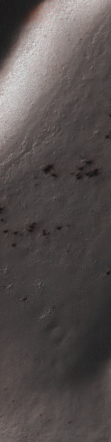
Daga Vallis


The THEMIS VIS camera contains 5 filters. The data from different filters can be combined in multiple ways to create a false color image. These false color images may reveal subtle variations of the surface not easily identified in a single band image. Today's false color image shows part of Daga Vallis on Eos Mensa.

Orbit Number: 2012 Latitude: -11.8784 Longitude: 317.167 Instrument: VIS Captured: 2002-05-29 04:14

Image credit: NASA/JPL-Caltech/Arizona State University

Wednesday, December 17, 2014

Possible Methane Sources and Sinks


This illustration portrays possible ways that methane might be added to Mars' atmosphere (sources) and removed from the atmosphere (sinks). NASA's Curiosity Mars rover has detected fluctuations in methane concentration in the atmosphere, implying both types of activity occur in the modern environment of Mars.

A molecule of methane consists of one atom of carbon and four atoms of hydrogen. Methane can be generated by microbes and can also be generated by processes that do not require life, such as reactions between water and olivine (or pyroxene) rock. Ultraviolet radiation (UV) can induce reactions that generate methane from other organic chemicals produced by either biological or non-biological processes, such as comet dust falling on Mars. Methane generated underground in the distant or recent past might be stored within lattice-structured methane hydrates called clathrates, and released by the clathrates at a later time, so that methane being released to the atmosphere today might have formed in the past.

Winds on Mars can quickly distribute methane coming from any individual source, reducing localized concentration of methane. Methane can be removed from the atmosphere by sunlight-induced reactions (photochemistry). These reactions can oxidize the methane, through intermediary chemicals such as formaldehyde and methanol, into carbon dioxide, the predominant ingredient in Mars' atmosphere.

Image credit: NASA/JPL-Caltech/SAM-GSFC/University of Michigan

Note: For more information, see:
* PIA19086: Tunable Laser Spectrometer on NASA's Curiosity Mars Rover
* PIA19087: Methane Measurements by NASA's Curiosity in Mars' Gale Crater
* PIA19089: Some Data from Detection of Organics in a Rock on Mars
* PIA19090: Comparing 'Cumberland' With Other Samples Analyzed by Curiosity
* PIA19091: Mars Has Ways to Make Organics Hard to Find
* NASA Rover Finds Active and Ancient Organic Chemistry on Mars
* How NASA Curiosity Instrument Made First Detection of Organic Matter on Mars
* Curiosity Detects Methane Spike on Mars

Friday, December 12, 2014

Impact Crater in Morava Valles


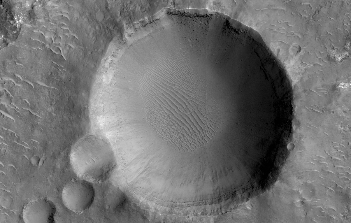
Morava Valles is a small outflow channel in the Margaritifer Sinus region of Mars. Several of the interior channels of Morava emanate from a localized region of terrain that is caving in, also called “subsidence.”

This region, comprised of jumbled blocks of flat-topped hills, is known as chaotic terrain. These channels, which emerge from the chaotic region, are separated by elongated hills that coalesce into a single channel before disappearing into the Margaritifer Chaos to the north. Chaotic terrains are thought to be the regions where ground water erupted catastrophically onto the surface, forming highly erosive flows that carved the outflow channels. The hills just downstream of the chaotic source region were shaped into streamlined islands by the erosive flows, forming blunt rounded ends in the upstream direction and tapering towards the north in the downstream direction.

Although windblown sediments now cover the original flood-carved channel floor in a sea of dunes, a 1.5 kilometer diameter impact crater provides a window into the sediment on the channel floor. The crater exposes several layers along its upper walls including a distinct bouldery layer just below the mantle of windblown sediments. These boulders may have originated from the eruption site and were transported and emplaced on the channel floor by high energy floods. Alternatively, these bouldery layers may be lava that subsequently flowed across the flood scarred channel floors.

Image credit: NASA/JPL/University of Arizona

Note: For more information, see PIA19116: Seeing Beneath the Surface in Morava Valles.

Tuesday, December 9, 2014

Gale Crater Lake


This illustration depicts a lake of water partially filling Mars' Gale Crater, receiving runoff from snow melting on the crater's northern rim. Evidence of ancient streams, deltas and lakes that NASA's Curiosity Mars rover mission has found in the patterns of sedimentary deposits in Gale Crater suggests the crater held a lake such as this more than three billion years ago, filling and drying in multiple cycles over tens of millions of years.

Gale Crater is 96 miles (154 kilometers) in diameter. This view is looking toward the southeast. The land surface in this illustration is the area's modern shape. Three billion years ago, the rim would have been higher and less eroded. A large layered mountain, Mount Sharp, now stands in the middle of Gale Crater. Accumulation of sediments in lakes, deltas, streams and wind-blown deposits is proposed to have formed the layers making up the lower portion of the mountain. When the crater first held a lake, it might have had central peak, much smaller than Mount Sharp, formed as a rebound from the impact that excavated the crater. Such a peak might have appeared as an island in the lake.

Illustration credit: NASA/JPL-Caltech

Note: For more information, see:
* PIA19067: Curiosity Mars Rover's Route from Landing to Base of Mount Sharp
* PIA19068: Inclined Martian Sandstone Beds Near 'Kimberley'
* PIA19069: Bedding Pattern Interpreted as Martian Delta Deposition
* PIA19070: Sets of Beds Inclined Toward Mount Sharp
* PIA19071: How a Delta Forms Where River Meets Lake
* PIA19072: Sol 696 (July 22, 2014), Left
* PIA19073: Multiple Deltas Built Out Over Time
* PIA19074: Sedimentary Signs of a Martian Lakebed
* PIA19075: Thin-Laminated Rock in 'Pahrump Hills' Outcrop
* PIA19076: Cross-Bedding at 'Whale Rock'
* PIA19077: Crystals May Have Formed in Drying Martian Lake
* PIA19078: Sediment Accumulation in Dry and Wet Periods
* PIA19079: Sedimentation and Erosion in Gale Crater, Mars
* PIA19081: Martian Rock's Evidence of Lake Currents
* NASA's Curiosity Rover Finds Clues to How Water Helped Shape Martian Landscape
* Mars Mountain was All Wet

Monday, December 8, 2014

Enigmatic Feature in Athabasca Lava Flows


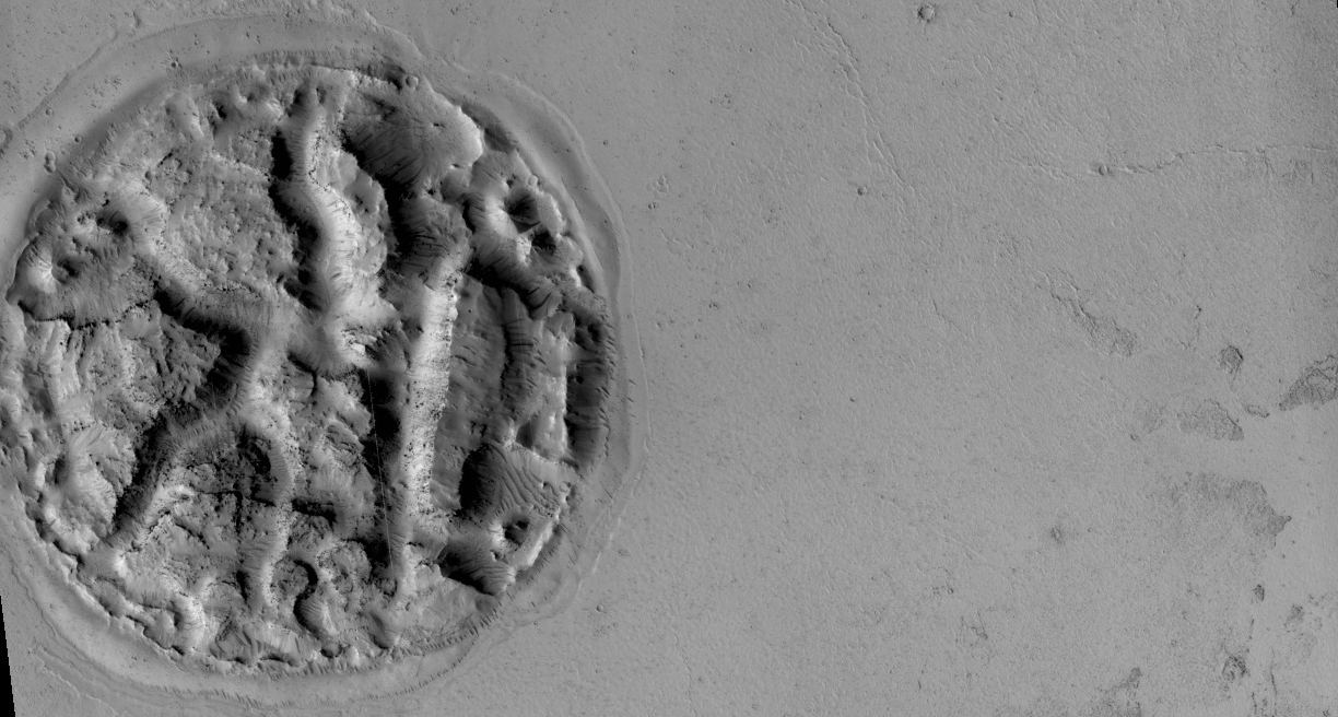
What is this enigmatic landform?

The circular feature is nearly 2 kilometers (1.2 miles) wide. It looks like a circular island surrounded by a "sea" of smooth-looking lava flows. The Athabasca region contains some of the youngest lava flows on Mars. Therefore, it is highly possible that volcanism played a role in creating this feature.

Perhaps lava has intruded underneath this mound and pushed it up from beneath. It looks as if material is missing from the mound, so it is also possible that there was a significant amount of ice in the mound that was driven out by the heat of the lava. There are an array of features like this in the region that continue to puzzle scientists.

We hope that close inspection of this HiRISE image, and others around it, will provide some clues regarding its formation.

Image credit: NASA/JPL/University of Arizona

Note: For more information, see PIA18932: An Enigmatic Feature in Athabasca Lava Flows.

Sunday, December 7, 2014

Clays Along the Coprates Chasma Plateau


This image shows exposures of deposits along the plateau just to the south of Coprates Chasma.

Whereas Coprates Chasma and many of the other chasmata of Valles Marineris contain kilometer-thick light-toned mounds made up of sulfates, several of the deposits along the plateau have signatures of clays. This indicates that water was here for extensive periods of time to cause the plains to weather and alter into clays.

Image credit: NASA/JPL/University of Arizona

Note: For more information, see PIA18933: Clays along the Coprates Chasma Plateau.

Saturday, December 6, 2014

Dunes and Wind Streaks in Arabia Terra


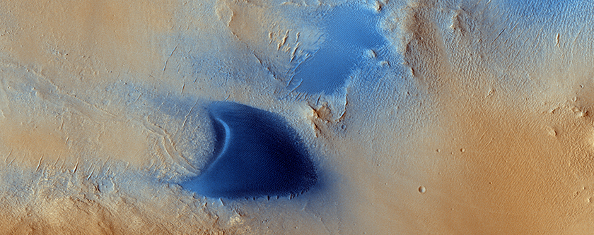
Arabia Terra is one of the more dusty regions on Mars, where ever-falling red dust covers the surface allowing only minor variations in color and tone. One exception is when wind-driven, dark-toned sand moves across the surface ejecting the bright dust into the atmosphere to reveal the dust-free surface below.

This HiRISE image shows sand dunes with surrounding larger tear drop-shaped light streaks pointing west (or, to the left). This orientation, along with the morphology of the local dunes, indicates winds from the east have stripped sand particles off the dunes and carried them downwind to form these light streaks. More importantly, active sand has a role in the slow erosion of the rocks here and the overall landscape evolution of the region.

Image credit: NASA/JPL/University of Arizona

Note: For more information, see PIA18931: Dunes and Wind Streaks in Arabia Terra.

Friday, December 5, 2014

Braided TARs in Syrtis Major


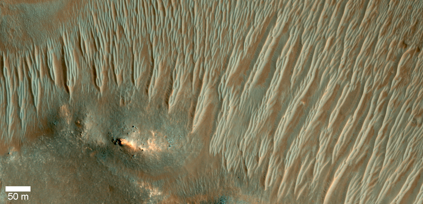
Transverse aeolian ridges (TARs) are commonly found throughout the Martian tropics, including rocky regions such as Syrtis Major that are largely devoid of dust.

These bright wind-blown ripples most often occur in simple sets of ridges with regular size and spacing. Typical TARs stand a few meters tall and have a wavelength (that is to say, separation) of 30 to 60 meters. HiRISE has not detected any changes among the TARs today, suggesting that they are inactive.

In this scene, we see TARs with a highly unusual morphology. Instead of single ridges, we see sets of small ridges that are separated by about 50 meters. The smaller ripples are spaced only 5 to 8 meters apart. Between the smaller ripples are even smaller striations that are perpendicular to the ridge crests with regular spacings of less than 2 meters.

This image raises a number of puzzling questions. Why are the ripples organized into two distinct wavelengths? Did the different wavelengths result from different processes or from different conditions? When did these wavelength-specific conditions or processes take place? Did they occur together, or did they alternate, or did one take place after the other? Were the processes depositional or erosional, or both?

The complexity of Martian TARs makes us think twice about any single explanation for their origin.

Image credit: NASA/JPL/University of Arizona

Note: For more information, see PIA18930: Braided TARs in Syrtis Major.

Thursday, December 4, 2014

False Color Arsia Mons


This false color image shows part of the summit caldera of Arsia Mons. The mottled bluish tones are from clouds.

Orbit Number: 56650 Latitude: -9.51318 Longitude: 239.933 Instrument: VIS Captured: 2014-09-21 07:27

Image credit: NASA/JPL-Caltech/Arizona State University

Wednesday, December 3, 2014

False Color Noctis Labyrinthus


This false color image covers part of Noctis Labyrinthus. The bluish tone in the lower elevation depressions may indicate atmospheric haze.

Orbit Number: 56612 Latitude: -5.85669 Longitude: 255.491 Instrument: VIS Captured: 2014-09-18 04:23

Image credit: NASA/JPL-Caltech/Arizona State University

Tuesday, December 2, 2014

False Color Claritas Fossae


This false color image shows part of Claritas Fossae.

Orbit Number: 56562 Latitude: -42.1269 Longitude: 263.184 Instrument: VIS Captured: 2014-09-14 01:23

Image credit: NASA/JPL-Caltech/Arizona State University

Saturday, November 29, 2014

False Color Tithonium and Ius Chasmata


This false color image of the region including both Tithonium and Ius Chasmata includes a bluish region in both canyons. This may indicate an atmospheric haze. The potential haze appears to be more widespread in Ius Chasma.

Orbit Number: 56524 Latitude: -5.5587 Longitude: 273.654 Instrument: VIS Captured: 2014-09-10 22:30

Image credit: NASA/JPL-Caltech/Arizona State University

Friday, November 28, 2014

False Color Ascraeus Mons


Today's VIS image is a false color image of part of the northern flank of Ascreaus Mons. The bluish section at the top of the image may indicate an atmospheric haze.

Orbit Number: 56512 Latitude: 13.2761 Longitude: 257.162 Instrument: VIS Captured: 2014-09-09 22:53

Image credit: NASA/JPL-Caltech/Arizona State University

Thursday, November 20, 2014

Pink Cliffs


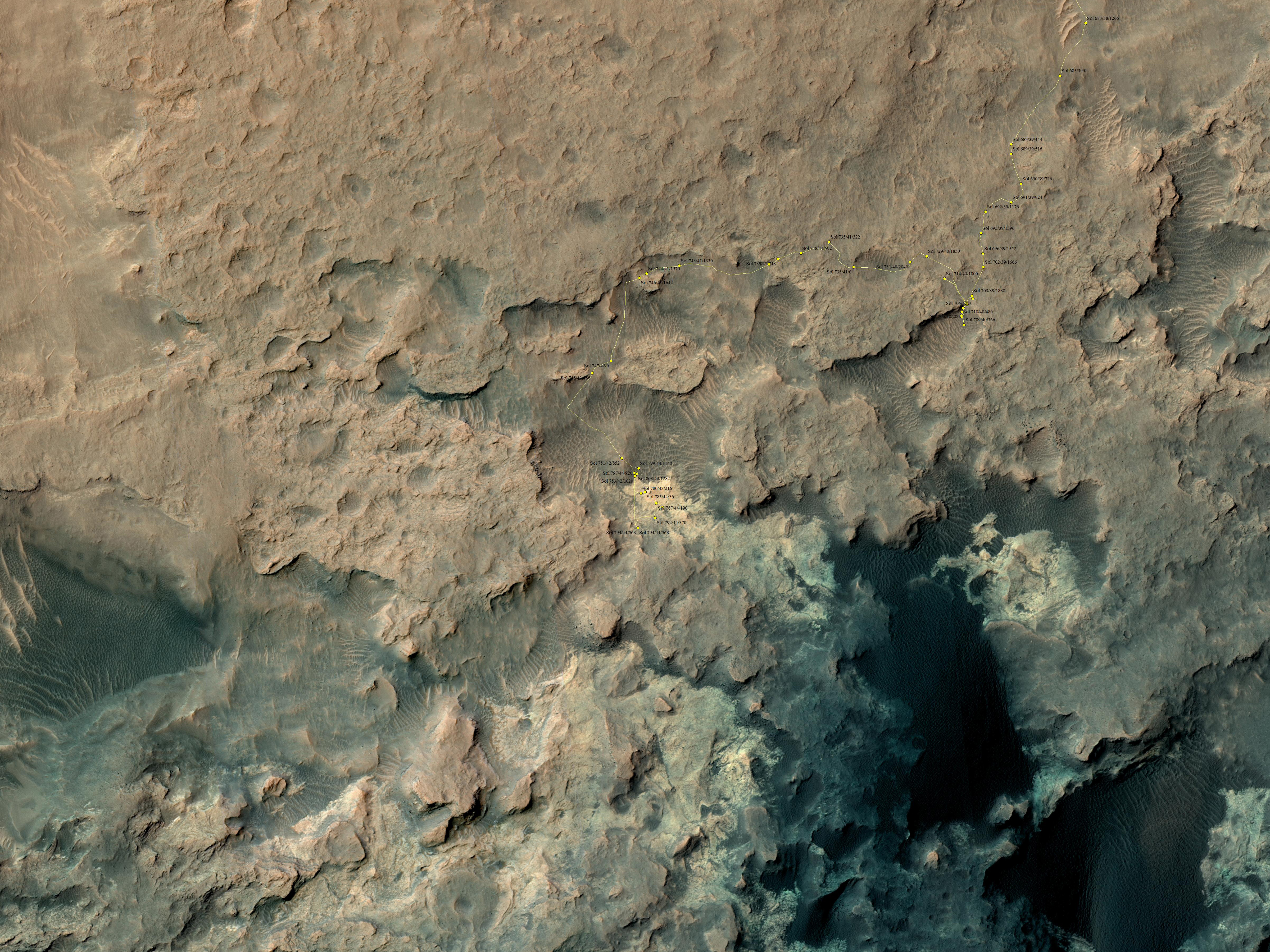
This small ridge, about 3 feet (1 meter) long, appears to resist wind erosion more than the flatter plates around it. Such differences are among the rock characteristics that NASA's Curiosity Mars rover is examining at selected targets at the base of Mount Sharp.

The ridge pictured here, called "Pink Cliffs," is within the "Pahrump Hills" outcrop forming part of the basal layer of the mountain. This view is a mosaic of exposures acquired by Curiosity's Mast Camera (Mastcam) shortly before a two-week walkabout up the outcrop, scouting to select which targets to examine in greater detail during a second pass.

Pink Cliffs is one of the targets chosen for closer inspection. This image combines several frames taken with the Mastcam on October 7, 2014, the 771st Martian day, or sol of Curiosity's work on Mars. The color has been approximately white-balanced to resemble how the scene would appear under daytime lighting conditions on Earth.

Figure 1 is a version with a scale bar overlaid on the image.

An image showing the Pahrump Hills walkabout route is at PIA19039. An overhead map showing the walkabout drives, from Sol 780 (Oct. 16) to Sol 794 (Oct. 30) is at http://mars.jpl.nasa.gov/msl/images/Curiosity_Location_Sol803-full.jpg.

Image credit: NASA/JPL-Caltech/MSSS

Wednesday, November 19, 2014

Spring in Inca City V


A significant event has occurred in Inca City. The layer of seasonal ice has started to develop long cracks. This is visible in the orange-colored band adjacent to the araneiforms. Fans of dust are emerging from long linear cracks. The cracks form when large plates of ice have no easily ruptured weak spots to release the pressure from gas building up underneath, so the ice simply cracks.

There are also more fans on the ridge at the top of the image, and more have appeared in between the araneiforms. We do not have any analogous processes occurring naturally on Earth: this is truly Martian.

Image credit: NASA/JPL/University of Arizona

Note: For more information, see PIA18896: Spring in Inca City V.

Tuesday, November 18, 2014

Spring in Inca City IV


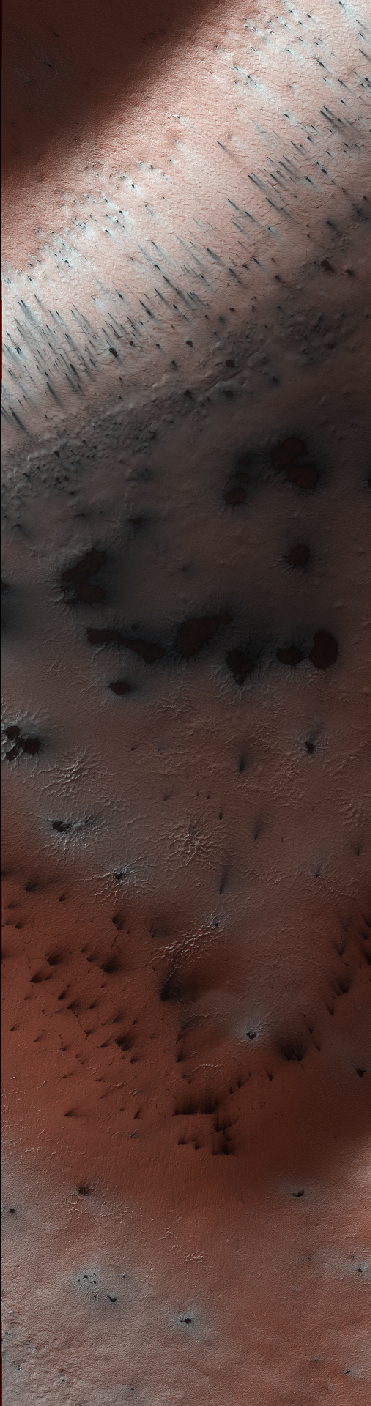
At certain times in spring, fans take on a gray or blue appearance. This is the time in Inca City when this phenomenon happens.

On the ridge at the top of the image fans have lengthened and now look more gray than the blotches on the araneiforms. At the bottom of the image they are distinctly blue in color.

Two theories have been suggested: perhaps fine particles sink into the seasonal layer of ice so they no longer appear dark. Or, maybe the gas that is released from under the ice condenses and falls to the surface as a bright fresh layer of frost. It is quite likely that both of these theories are correct.

Image credit: NASA/JPL/University of Arizona

Note: For more information, see PIA18895: Spring in Inca City IV.

Monday, November 17, 2014

Spring in Inca City III


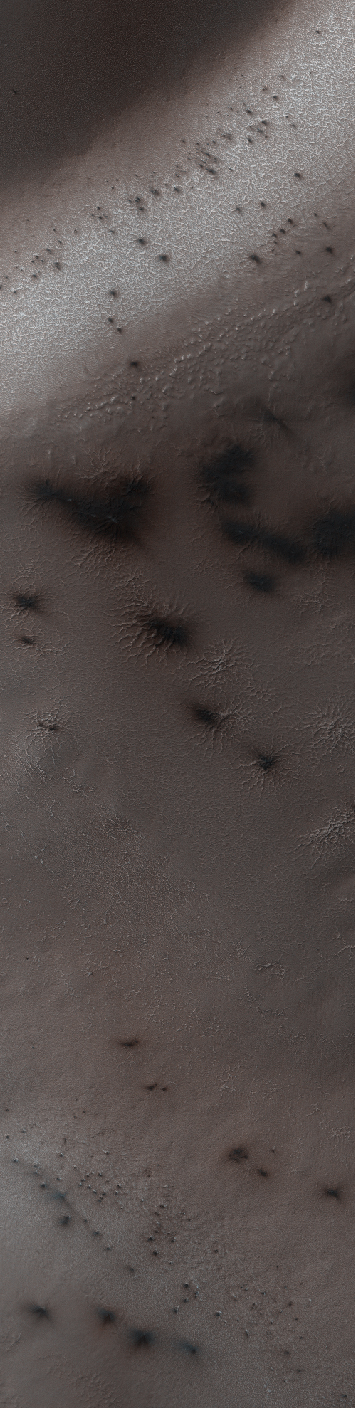
In Inca City another week has passed, and there are a few more fans on the ridge. We are studying the sequence of spring activity with the help of citizen scientists at the Planetfour website, sponsored by Zooniverse.

Citizens of planet Earth log on and identify and measure fans and blotches in the South polar region of Mars imaged by HiRISE. With their help we can study the polar weather by looking at how the fan directions change through the spring.

We see how the number of fans and blotches depends on the thickness of the ice layer and how high the sun is in the sky. If you would like to be a part of this endeavor join us at www.planetfour.org.

Image credit: NASA/JPL/University of Arizona

Note: For more information, see PIA18894: Spring in Inca City III.

Sunday, November 16, 2014

Spring in Inca City II


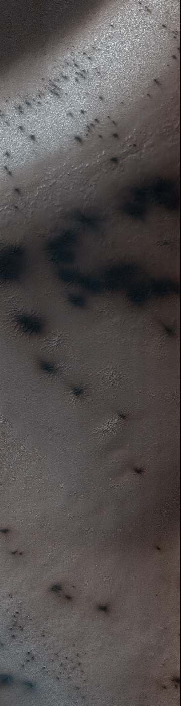
It is about two weeks later in Inca City and the season is officially spring. Numerous changes have occurred. Large blotches of dust cover the araneiforms. Dark spots on the ridge show places where the seasonal polar ice cap has ruptured, releasing gas and fine material from the surface below.

At the bottom of the image fans point in more than one direction from a single source, showing that the wind has changed direction while gas and dust were flowing out. Was the flow continuous or has the vent opened and closed?

Image credit: NASA/JPL/University of Arizona

Note: For more information, see PIA18893: Spring in Inca City II.

Saturday, November 15, 2014

Spring in Inca City I


Every winter a layer of carbon dioxide ice — or, dry ice — condenses in the Southern polar region, forming a seasonal polar cap less than 1 meter deep. Early in the spring the ice layer begins to sublimate (going directly from a solid to gas) from the top and bottom of the ice layer. Under the ice gas pressure builds up until a weak spot in the ice layer ruptures. The gas rushes out and as it escapes it erodes a bit of the surface.

Fine particles are carried by the gas to the top of the ice and then fall out in fan-shaped deposits. The direction of the fan shows the direction either of the wind or down the slope. If the wind is not blowing a dark blotch settles around the spot the gas escaped.

This region is known informally as Inca City, and it has a series of distinctive ridges. On the floor between the ridges are radially organized channels, known colloquially as spiders, more formally called "araneiforms." The channels have been carved in the surface over many years by the escaping pressurized gas. Every spring they widen just a bit.

This was the first image to be acquired after the sun rose on Inca City, marking the end to polar night. A few fans are visible emerging from the araneiforms.

Image credit: NASA/JPL/University of Arizona

Note: For more information, see PIA18892: Spring in Inca City I.

Sunday, November 2, 2014

Partially-Filled Impact Crater in Elysium Planitia


This image shows an impact crater that was cut by lava in the Elysium Planitia region of Mars. The relatively flat, shallow floor, rough surface texture, and possible cooling cracks seem to indicate that the crater was partially filled with lava. The northern part of the image also shows a more extensive lava flow deposit that surrounds the impact ejecta of the largest impact crater in the image.

Which way did the lava flow? It might appear that the lava flowed from the north through the channel into the partially filled crater. However, if you look at the anaglyph with your red and blue 3D glasses, it becomes clear that the partially filled crater sits on top of the large crater's ejecta blanket, making it higher than the lava flow to the north. Since lava does not flow uphill, that means the explanation isn't so simple.

We have seen much evidence for lava flows in this region that flowed to much higher levels than the present surface, then deflated or drained away. That may have happened here: lava flowed from from north to south to fill this crater, but then it drained back to the north, carving this channel.

The topographic information that we gained from having a stereo pair let us answer a question that we could not have with only a single image. This is a great example of why we take stereo images, where the two images are used to make a 3D image.

Image credit: NASA/JPL/University of Arizona

Note: For more information, see PIA18887: Which Way is Up?