
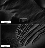
Several types of downhill flow features have been observed on Mars. This image from the High Resolution Imaging Science Experiment (HiRISE) camera on NASA's Mars Reconnaissance Orbiter is an example of a type called "linear gullies." Linear gullies are characterized by relatively constant width and by raised banks or levees along the sides. Unlike gullies caused by water-lubricated flows on Earth and possibly on Mars, they don't have aprons of debris at the downhill end of the channel. The grooves shown here, on the side of a large sand dune inside Russell Crater, are the longest linear gullies known, extending almost 1.2 miles (2 kilometers) down this dune slope.
New research points to chunks of frozen carbon dioxide, commonly called "dry ice," creating linear gullies by gliding down sandy slopes on cushions of carbon-dioxide gas sublimating from the dry ice. Linear gullies are on mid-latitude sandy slopes, where the ground is covered with carbon-dioxide frost in Martian winter. Before-and-after pairs of HiRISE images indicate that the linear gullies are formed during early spring. Some linear gullies -- such as the ones in the magnified section of this image shown as Figure 1 -- have pits at the downhill end that could be caused by a block of dry ice ending its slide and resting in place as it sublimates away.
This image is a portion of the HiRISE exposure cataloged as PSP_001440_1255 taken on November 16, 2006, at 54.25 degrees south latitude, 12.92 degrees east longitude.
Photo credit: NASA/JPL-Caltech/University of Arizona
Note: For more information, see Marks on Martian Dunes May Be Tracks of Dry-Ice Sleds; also, Dry Ice "Snowboards" on Mars.
No comments:
Post a Comment