Sunday, August 31, 2014

West Rim of Endeavour Crater


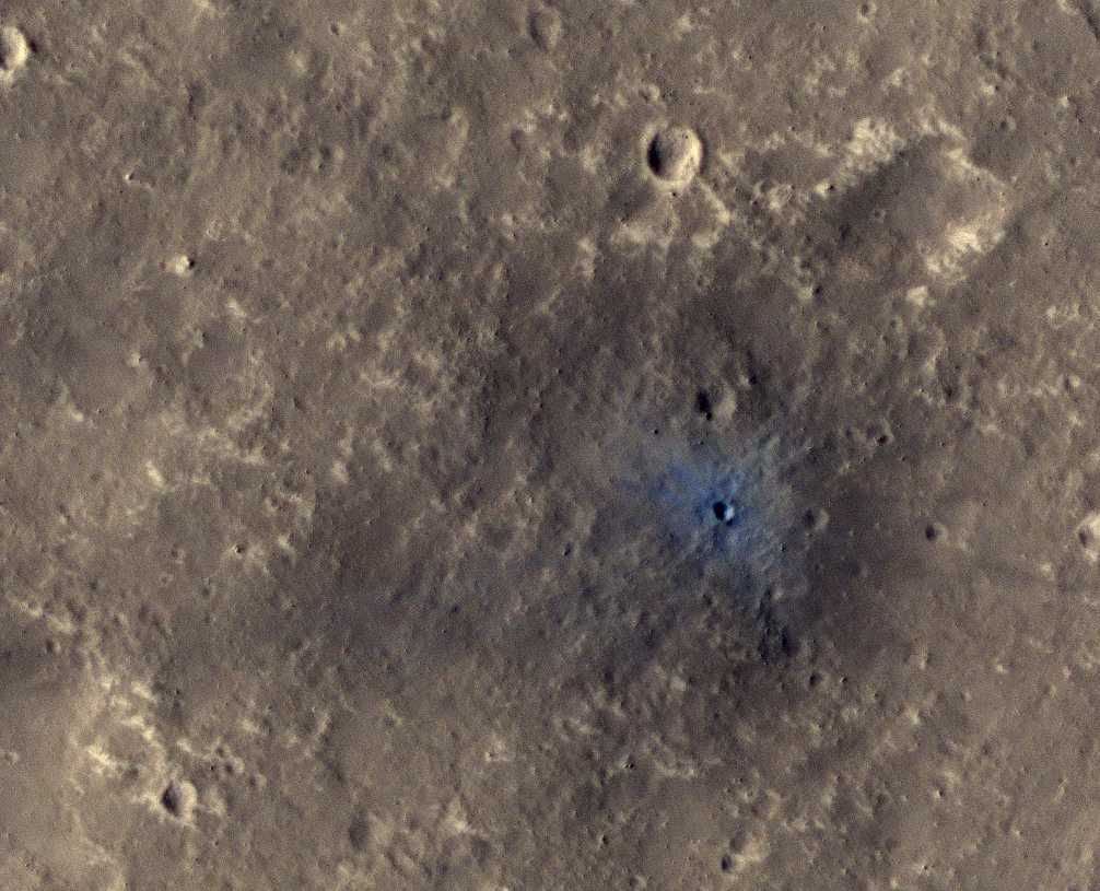
NASA's Mars Exploration Rover Opportunity captured this scene looking farther southward just after completing a southward drive, in reverse, during the 3,749th Martian day, or sol, of the rover's work on Mars (August 10, 2014).

The foreground of this view from the rover's mast-mounted navigation camera (Navcam) includes the top of the rover's low-gain antenna, at lower right, and the rear portion of the rover's deck, with the sundial of a camera calibration target. For scale, the largest of the sundial's concentric rings has an outer diameter of 3.15 inches (8 centimeters).

The ground beyond the rover includes some windblown lines of sand. At the horizon is part of the crest line of the west ridge of Endeavour Crater. The Sol 3749 drive covered 338 feet (103 meters) along the outer slope of the crater rim. A map of the area with the Sol 3749 endpoint marked is available online at http://mars.nasa.gov/mer/mission/tm-opportunity/opportunity-sol3751.html.

Image credit: NASA/JPL-Caltech

Note: For more information, see Memory Reformat Planned for Opportunity Mars Rover.

Saturday, August 30, 2014

Slope Streaks in Terra Sabaea


This VIS image shows dark slope streaks in an unnamed crater in Terra Sabaea. These features are believed to be formed by material moving downslope, removing the dust cover and revealing darker material.

Orbit Number: 56045 Latitude: 11.9172 Longitude: 46.5184 Instrument: VIS Captured: 2014-08-02 12:09

Photo credit: NASA/JPL-Caltech/Arizona State University

New Impact Crater in Elysium Planitia


InSight (Interior Exploration using Seismic Investigations, Geodesy and Heat Transport) is a NASA Discovery Program mission that will place a single geophysical lander on Mars in September 2016 to study its deep interior.

InSight needs seismic signals, and one sure way to get them is from the impact of bolides onto Mars. InSight can detect large impacts that are far from the lander and smaller impacts that are closer.

This recent HiRISE image, acquired to certify a landing site for the mission, shows a distinctive crater with a very sharp rim and ejecta that is darker and bluer than almost all of this dust-covered region. This must be a very recent impact because there hasn't been sufficient time for atmospheric dust to settle over this spot and re-brighten the surface.

In fact, previous images suggest it formed between 2008 and 2012. This illustrates the type of feature that orbiting cameras will search for during the InSight mission, to attempt to correlate seismic signals to the point of origin.

This is a stereo pair with ESP_037684_1845.

Image credit: NASA/JPL/University of Arizona

Note: For more information, see PIA18776: A New Impact Crater Near NASA's InSight Landing Region.

Friday, August 29, 2014

Ares Vallis


This VIS image shows a portion of Ares Vallis.

Orbit Number: 56035 Latitude: 9.15576 Longitude: 335.227 Instrument: VIS Captured: 2014-08-01 16:23

Photo credit: NASA/JPL-Caltech/Arizona State University

Ice-Rich Mantling Deposits East of Reull Vallis


The mid-latitudes of Mars (approximately 30 to 60 degrees, north and south) are covered in ice-rich mantling deposits in varying states of degradation.

This mantle is thought to be deposited as snow during periods when the angle of the tilt of Mars’ rotational axis—called obliquity—is much higher, which last happened around 10 million years ago.

This HiRISE image shows terrain typical of these mantling deposits in the Southern Hemisphere, east of Reull Vallis. The pitted texture suggests that ice is sublimating out from the deposits as the region is warmed under current lower obliquity conditions.

Image credit: NASA/JPL/University of Arizona

Note: For more information, see PIA18775: Mantled Terrain in the Southern Mid-Latitudes.

Thursday, August 28, 2014

Ravi Vallis


This VIS image shows a portion of Ravi Vallis.

Orbit Number: 56073 Latitude: 0.182473 Longitude: 320.807 Instrument: VIS Captured: 2014-08-04 19:24

Photo credit: NASA/JPL-Caltech/Arizona State University

Wednesday, August 27, 2014

Landslide Deposit Within a Doublet Crater in Tyrrhena Terra


Today's VIS image shows a landslide deposit within a complex crater (note the ejecta to the top and bottom of the image). There is a smaller complex crater on the ejecta to the north of the larger crater. This "doublet" crater with the linear interior rim is formed when two impactors hit the surface simultaneously. The impactors are initially all part of the same meteor. The larger crater may have formed from multiple impactors.

Orbit Number: 56056 Latitude: -19.0844 Longitude: 93.6361 Instrument: VIS Captured: 2014-08-03 09:43

Photo credit: NASA/JPL-Caltech/Arizona State University

Tuesday, August 26, 2014

Dunes in Olympia Undae


The dunes in this VIS image are part of Olympia Undae.

Orbit Number: 55336 Latitude: 79.6049 Longitude: 159.723 Instrument: VIS Captured: 2014-06-05 04:13

Photo credit: NASA/JPL-Caltech/Arizona State University

Saturday, August 23, 2014

Dunes and Gullies in a Vastitas Borealis Crater


This unnamed crater has gullies along the inner rim and dunes on the crater floor.

Orbit Number: 55306 Latitude: 63.6919 Longitude: 292.265 Instrument: VIS Captured: 2014-06-02 17:00

Photo credit: NASA/JPL-Caltech/Arizona State University

Note: This impact crater is located in Vastitas Borealis.

Bonanza King Fails "Start Hole" Test


This image from the front Hazard Avoidance Camera (Hazcam) on NASA's Curiosity Mars rover shows the rover's drill in place during a test of whether the rock beneath it, "Bonanza King," would be an acceptable target for drilling to collect a sample. Subsequent analysis showed that the rock budged during the procedure and did not pass the test.

The image was taken during the 724th Martian day, or sol, of Curiosity's work on Mars (August 19, 2014, PDT). The rover was doing a mini-drill procedure, which is part of evaluating the target in advance of full-depth, sample-collection drilling. One step in the procedure, called "start hole," uses the hammering action of the percussive drill to create a small indentation in the rock. During this part of the test, the rock moved slightly, the rover sensed that instability in the target, and protective software properly halted the procedure. After analysis of the target's instability, the rover team decided on August 21, 2014, to drive Curiosity away from this Bonanza King site and resume the trek toward long-term destinations on the slopes of Mount Sharp and perhaps a shorter-term science destination at an outcrop called "Pahrump Hills."

The site in this southward-looking image is at the northeastern end of sandy-floored "Hidden Valley." The largest of the individual flat rocks in the foreground are a few inches (several centimeters) across. For scale, the rover's left front wheel, visible at left, is 20 inches (0.5 meter) in diameter.

A map showing Hidden Valley is at http://photojournal.jpl.nasa.gov/catalog/PIA18408.

Image credit: NASA/JPL-Caltech

Note: For more information, see Mars Rover Team Chooses Not to Drill 'Bonanza King' and PIA18478: Loose Rock Leads to Incomplete Drilling.

Friday, August 22, 2014

Galaxias Fossae


The channel-like features at the bottom of this VIS image are part of Galaxias Fossae.

Orbit Number: 55286 Latitude: 38.6943 Longitude: 142.826 Instrument: VIS Captured: 2014-06-01 01:41

Photo credit: NASA/JPL-Caltech/Arizona State University

Impact Craters in Hellas Planitia


Scarring the southern highlands of Mars is one of the Solar System’s largest impact basins: Hellas, with a diameter of 2300 km and a depth of over 7 km.

Hellas is thought to have formed between 3.8 and 4.1 billion years ago, when a large asteroid hit the surface of Mars. Since its formation, Hellas has been subject to modification by the action of wind, ice, water and volcanic activity.

Impact craters have also since pock-marked this vast basin floor, two of which are the focus of this image, taken by the High Resolution Stereo Camera on ESA’s Mars Express on 17 December 2013. The ground resolution is about 15 meters per pixel.

These craters lie in the deepest, western portion of Hellas, and such a clear view is unusual because dust clouds typically obscure the basin floor. Indeed, this region seems to be covered by a thick blanket of dust.

The larger of the two craters is about 25 km across. A flow of material appears to have been transported from the top left of the scene and into the crater. Zooming in to the smooth mound and the area immediately around it reveals interesting textures that likely resulted from this flow.

Flow features are also seen outside of the craters, and in particular, at the center left of the image near the top of the frame. Material also seems to have cascaded from the larger crater’s rim and into a neighboring smaller crater, at the far left of the image.

The morphology of many features in the Hellas Basin and its surroundings strongly suggests the presence of ice and glaciers.

For example, in the foreground and around the crater rim, polygons of patterned ground are visible which indicates the presence of water – this pattern occurs when fine grained and porous wet soil freezes.

Indeed, in the deepest parts of the basin, the atmospheric pressure is about 89% higher than at the surface, which may even offer conditions suitable for water. Radar images from NASA’s Mars Reconnaissance Orbiter suggest that some craters in Hellas might contain water-ice glaciers several hundred meters thick, buried under layers of dust.

See more images from this region at the DLR website and in this previous ESA release.

Image credit: ESA/DLR/FU Berlin

Thursday, August 21, 2014

Marte Vallis


The streamlined islands in this VIS image are part of Marte Vallis.

Orbit Number: 55247 Latitude: 18.925 Longitude: 184.18 Instrument: VIS Captured: 2014-05-28 20:46

Photo credit: NASA/JPL-Caltech/Arizona State University

Brushed-Off Bonanza King


NASA's Curiosity Mars rover used the Dust Removal Tool on its robotic arm to brush aside reddish, more-oxidized dust, revealing a gray patch of less-oxidized rock material at a target called "Bonanza King," visible in this image from the rover's Mast Camera (Mastcam).

The Mastcam's right-eye camera, which has a telephoto lens, took this image on August 17, 2014, during the 722nd Martian day, or sol, of Curiosity's work on Mars. The brushing activity occurred earlier the same sol. The rover team is evaluating Bonanza King as a possible drilling target. The mission has previously drilled into three target rocks to collect sample powder for analysis by the rover's onboard laboratory instruments.

The brushed area is about 2.5 inches (6 centimeters) across. It reveals thin, white, cross-cutting veins. They might be sulfate salts or another type of mineral that precipitated out of solution and filled fractures in the rock. These thin veins might be related to wider light-toned veins and features in the surrounding rock.

To the left of the brushed patch is a row of five smaller and less conspicuous spots where dust has been partially removed. These are at points on Bonanza King that were zapped with the laser of Curiosity's Chemistry and Camera (ChemCam) instrument on Sol 719 (August 14, 2014). Color balancing and contrast adjustment have been used in preparing this image from Mastcam's raw image of this exposure.

Drilling a shallow test hole is the next step in evaluating this location for full-depth drilling to collect a sample. The shallow "mini-drill" test enables assessing whether powder from the drilling tends to clump.

Bonanza King is on a ramp rising from the northeastern end of "Hidden Valley," between Curiosity's August 2012 landing site in Gale Crater and destinations on Mount Sharp within the crater.

Image credit: NASA/JPL-Caltech/MSSS

Note: For more information, see PIA18477: A Bonanza of Clues About Mars and PIA18479: Martian Rocks Rich in Silicon.

Wednesday, August 20, 2014

Anio Valles


The sinuous channel at the bottom of today's VIS image is called Anio Valles.

Orbit Number: 55239 Latitude: 35.1204 Longitude: 57.3396 Instrument: VIS Captured: 2014-05-28 04:52

Photo credit: NASA/JPL-Caltech/Arizona State University

Colliding Atmospheres: Mars vs Comet Siding Spring


On October 19, 2014, Comet Siding Spring will pass by Mars only 132,000 km away--which would be like a comet passing about 1/3 of the distance between Earth and the Moon.

The nucleus of the comet won't hit Mars, but there could be a different kind of collision.

"We hope to witness two atmospheres colliding," explains David Brain of the University of Colorado's Laboratory for Atmospheric and Space Physics (LASP). "This is a once in a lifetime event!"

Everyone knows that planets have atmospheres. Lesser known is that comets do, too. The atmosphere of a comet, called its "coma," is made of gas and dust that spew out of the sun-warmed nucleus. The atmosphere of a typical comet is wider than Jupiter.

"It is possible," says Brain, "that the atmosphere of the comet will interact with the atmosphere of Mars. This could lead to some remarkable effects — including Martian auroras."

The timing could scarcely be better. Just last year, NASA launched a spacecraft named MAVEN to study the upper atmosphere of Mars, and it will be arriving in September 2014 barely a month before the comet.

MAVEN is on a mission to solve a longstanding mystery: What happened to the atmosphere of Mars? Billions of years ago, Mars had a substantial atmosphere that blanketed the planet, keeping Mars warm and sustaining liquid water on its surface. Today, only a wispy shroud of CO2 remains, and the planet below is colder and dryer than any desert on Earth. Theories for this planetary catastrophe center on erosion of the atmosphere by solar wind.

"The goal of the MAVEN mission is to understand how external stimuli affect the atmosphere of Mars," says Bruce Jakosky of LASP, MAVEN's principal investigator. "Of course, when we planned the mission, we were thinking about the sun and the solar wind. But Comet Siding Spring represents an opportunity to observe a natural experiment, in which a perturbation is applied and we can see the response."

Brain, who is a member of the MAVEN science team, thinks the comet could spark Martian auroras. Unlike Earth, which has a global magnetic field that shields our entire planet, Mars has a patchwork of "magnetic umbrellas" that sprout out of the surface in hundreds of places all around the planet. If Martian auroras occur, they would appear in the canopies of these magnetic umbrellas.

"That is one thing that we will be looking for with both MAVEN and Hubble Space Telescope," says Brain. "Any auroras we see will not only be neat, but also very useful as a diagnostic tool for how the comet and the Martian atmosphere have interacted."

The atmosphere of the comet includes not only streamers of gas, but also dust and other debris blowing off the nucleus at 56 kilometers per second relative to Mars. At that velocity, even particles as small as half a millimeter across could damage spacecraft. NASA's fleet of Mars orbiters including MAVEN, Mars Odyssey and Mars Reconnaissance Orbiter will maneuver to put the body of Mars between themselves and the comet’s debris during the dustiest part of the encounter.

"It's not yet clear whether any significant dust or gas will hit the Mars atmosphere," cautions Jakosky. "But if it does, it would have the greatest effects on the upper atmosphere."

Meteoroids disintegrating would deposit heat and temporarily alter the chemistry of upper air layers. The mixing of cometary and Martian gases could have further unpredictable effects. Although MAVEN, having just arrived at Mars, will still be in a commissioning phase, it will use its full suite of instruments to monitor the Martian atmosphere for changes.

"By observing both before and after, we hope to determine what effects the comet dust and gas have on Mars, if any," says Jakosky.

Whatever happens, MAVEN will have a ringside seat.

Video credit: NASA

Tuesday, August 19, 2014

Channels in Infrared


Near the bottom of this nighttime IR image are several channels. The dusty channel floors are darker (colder) than the rocky walls.

Orbit Number: 55224 Latitude: 4.19544 Longitude: 318.675 Instrument: IR Captured: 2014-05-26 22:27

Image credit: NASA/JPL-Caltech/Arizona State University

Note: I am somewhat confused as to the actual location of this image. On the one hand, the coordinates suggest that these channels should be within Xanthe Terra, between Shalbatana Vallis to the west and Da Vinci Crater to the southeast. However, my global map of Mars does not correspond with either these coordinates or the context map provided on the THEMIS webpage. So I'm not quite sure whether the coordinates or the context map is correct.

Endeavour Crater Panorama


This panorama combines several images from the navigation camera on NASA's Mars Exploration Rover Opportunity to show the rover's surroundings after surpassing 25 miles (40.23 kilometers) of total driving on Mars.

The component images were taken on July 29, 2014, during the 3,737th Martian day, or sol, of Opportunity's work on Mars, prior to that sol's drive. The rover's location was the point it reached with a drive of 157 feet (48 meters) on Sol 3735 (July 27, 2014), which brought Opportunity's total odometry to 25.01 miles (40.25 kilometers).

The site is on the western side of the west rim of Endeavour Crater. This full-circle vista is centered approximately to the east, with the crater rim extending northward in the left half and southward in the right half.

Image credit: NASA/JPL-Caltech

Monday, August 18, 2014

Bonanza King


This image from the Mast Camera (Mastcam) on NASA's Curiosity Mars rover shows a portion of the pale rock outcrop that includes the "Bonanza King" target chosen for evaluation as the mission's fourth rock-drilling site. Raised ridges on the flat rocks -- possible mineral veins -- are visible at upper and middle right. Tread marks from one of Curiosity's wheels are visible in the lower half of the image.

The left camera of the Mastcam pair acquired this image on August 12, 2014, during the 707th Martian day, or sol, of Curiosity's work on Mars. The width of the ground covered in the foreground is about 2.5 feet (about 75 centimeters). The image is in the Mastcam's raw color, as recorded by the camera under Martian lighting conditions.

The location is on a ramp rising from the northeastern end of "Hidden Valley," between Curiosity's August 2012 landing site in Gale Crater and destinations on Mount Sharp within the crater.

Image credit: NASA/JPL-Caltech

Note: For more information, see PIA18597: Looking Up the Ramp Holding 'Bonanza King' on Mars, PIA18599: Down Northeastern Ramp into 'Hidden Valley' on Mars, PIA18600: View Down 'Hidden Valley' Ramp at 'Bonanza King' on Mars, and Curiosity Mars Rover Prepares for Fourth Rock Drilling.

Sunday, August 17, 2014

Glacial Ridges and Channels in Eastern Hellas Planitia


Hellas Crater in the ancient highlands contains some of the clearest evidence on Mars for glacial processes. This image, on the eastern margin of the giant impact crater, shows a number of features consistent with glaciation.

There are roughly north-south running ridges and troughs which mark the deposition of sediment called moraine underneath or beside a glacier. There are also sinuous channels which may formed from meltwater underneath a glacier. A small (3.5 x 3.5 kilometer) cutout shows an example of the moraine and meltwater channel.

Image credit: NASA/JPL/University of Arizona

Note: For more information, see PIA18647: Glaciation at the Eastern Hellas Margin.

Saturday, August 16, 2014

Planum Boreum Layering


This VIS image shows the layering of the north polar cap.

Orbit Number: 55224 Latitude: 82.3714 Longitude: 287.856 Instrument: VIS Captured: 2014-05-26 22:55

Photo credit: NASA/JPL-Caltech/Arizona State University

Chasma Boreale Scarps


Chasma Boreale is the 560-kilometer long valley that cuts through the Northern Polar layered deposits of Mars.

The section that it exposes show fine scaled layering and a major unconformity, where the azimuth of the beds changes markedly. This is is characteristic of the polar layered deposits. The formation of the unconformity suggests a time when the lower sediments were being eroded rather than deposited. The extracted image shows a roughly 4 x 4 kilometer area across the unconformity.

The polar layered deposits are weakly cemented rocks, and so lying over the scarps you can see lines of mass wasting where dust and sand size particles have slumped downhill. This image is part of a planned stereo pair, and was in the late summer in the Northern Hemisphere of Mars.

Comparing images like this to those taken in previous years and in different seasons allows a more accurate understanding of current surface processes on the Red Planet.

This is a stereo pair with ESP_036515_2650.

Image credit: NASA/JPL/University of Arizona

Note: For more information, see PIA18646: The Side of Chasma Boreale.

Friday, August 15, 2014

Olympia Undae (Again)


Today's VIS image shows more of Olympia Undae, a large dune field located near the north polar cap.

Orbit Number: 55192 Latitude: 80.3803 Longitude: 136.098 Instrument: VIS Captured: 2014-05-24 07:42

Photo credit: NASA/JPL-Caltech/Arizona State University

Lava Cones and Flows in Southern Elysium Planitia


The north end of this long image shows a lava surface in southern Elysium Planitia. Small cones are common on the extensive young flood lavas in this region.

Here, the cones are larger than usual, perhaps approaching cinder cone sizes. What's really odd here is that the cones are associated with lighter areas with polygonal patterns. Such polygons are commonly visible on the denser portions of lava flows, while the rougher areas have more broken-up low-density crust.

But the shapes of these regions are unusual, and the association with cones suggest that the cones were source vents for local lava flows. Other interpretations are also possible.

Image credit: NASA/JPL/University of Arizona

Note: For more information, see PIA18645: Strange Cones and Flows.

Thursday, August 14, 2014

Olympia Undae


Today's VIS image shows part of the margin of Olympia Undae.

Orbit Number: 55190 Latitude: 78.4215 Longitude: 197.221 Instrument: VIS Captured: 2014-05-24 03:04

Photo credit: NASA/JPL-Caltech/Arizona State University

An Irregular, Upright Boulder in Ophir Planum


This image was targeted to cover part of a small “chaos” terrain, where there are lots of steep slopes.

A closeup shows a boulder or block casting a long shadow, at the end of a boulder trail down the slope, and we can see it moved from upper left to middle right. The trail has a odd repeating pattern, as if the boulder couldn't roll straight due to its shape.

The sun angle and shadow length indicate the boulder is about 6 meters high, whereas its width as seen from overhead is only about 3.5 meters, so indeed it has an irregular shape. Furthermore, it came to rest with its long axis pointed up.

This is a stereo pair with ESP_035700_1765.

Image credit: NASA/JPL/University of Arizona

Note: This boulder is located in Ophir Planum. For more information, see PIA18594: An Irregular, Upright Boulder on Mars and Tall Boulder Rolls Down Martian Hill, Lands Upright.

Wednesday, August 13, 2014

Dunes on the Edge of Planum Boreum


The dunes in this VIS image are located right at the edge of the polar cap.

Orbit Number: 55188 Latitude: 83.2929 Longitude: 118.562 Instrument: VIS Captured: 2014-05-23 23:53

Photo credit: NASA/JPL-Caltech/Arizona State University

Tuesday, August 12, 2014

Ascraeus Mons


The lava flows in today's VIS image are part of Ascraeus Mons.

Orbit Number: 55157 Latitude: 15.6 Longitude: 258.525 Instrument: VIS Captured: 2014-05-21 11:00

Photo credit: NASA/JPL-Caltech/Arizona State University

Saturday, August 9, 2014

Dunes Near Olympia Undae


The dunes in this VIS image are near the large dune field called Olympia Undae.

Orbit Number: 55154 Latitude: 78.8498 Longitude: 154.617 Instrument: VIS Captured: 2014-05-21 04:38

Photo credit: NASA/JPL-Caltech/Arizona State University

Friday, August 8, 2014

Uranius Tholus and Ceraunius Tholus


Today's VIS image crosses the summit of Uranius Tholus, as well as the western flank of Ceraunius Tholus.

Orbit Number: 55082 Latitude: 25.0892 Longitude: 262.299 Instrument: VIS Captured: 2014-05-15 06:50

Photo credit: NASA/JPL-Caltech/Arizona State University

Thursday, August 7, 2014

Olympia Undae


The dunes in this VIS image are part of Olympia Undae.

Orbit Number: 55061 Latitude: 79.4552 Longitude: 167.984 Instrument: VIS Captured: 2014-05-13 13:03

Photo credit: NASA/JPL-Caltech/Arizona State University

Wheel Tracks in Hidden Valley


This image from the Navigation Camera on NASA's Curiosity Mars rover shows wheel tracks printed by the rover as it drove on the sandy floor of a lowland called "Hidden Valley" on the route toward Mount Sharp. The image was taken during the 709th Martian day, or sol, of the rover's work on Mars (August 4, 2014). That was one day before the second anniversary, in Earth years, of Curiosity's landing on Mars.

Image credit: NASA/JPL-Caltech

Note: For more information, see NASA Mars Curiosity Rover: Two Years and Counting on Red Planet.

Wednesday, August 6, 2014

Ceraunius Tholus


Today's VIS image crosses the summit of Ceraunius Tholus.

Orbit Number: 55057 Latitude: 24.5638 Longitude: 263.026 Instrument: VIS Captured: 2014-05-13 05:27

Photo credit: NASA/JPL-Caltech/Arizona State University

Hidden Valley


This panorama of the landscape surrounding NASA's Curiosity Mars rover on July 31, 2014, offers a view into sandy lower terrain called "Hidden Valley," which is on the planned route ahead. The full-circle vista combines several images taken by Curiosity's Navigation Camera in the afternoon of the mission's 705th Martian day, or sol, after completion of Sol 705's drive of about 16 feet (4.9 meters). South is at the center, north at both ends.

For the preceding few weeks, Curiosity had been crossing a plateau studded with embedded, sharp rocks. The planned route ahead from this Sol 705 location takes the rover southwestward through Hidden Valley, across sandier ground. The valley is about 150 feet (about 45 meters) wide. For a map showing this area, see PIA18408.

For scale, the distance between Curiosity's parallel wheel tracks entering the scene near the left edge is about 9 feet (2.7 meters). The panorama is presented here as a cylindrical projection.

Image credit: NASA/JPL-Caltech

Note: For more information, see NASA Mars Rover Curiosity Nears Mountain-Base Outcrop.

Tuesday, August 5, 2014

Dunes in Vastitas Borealis


The small, dark dunes in this VIS image are located on the northern plains [Vastitas Borealis].

Orbit Number: 54994 Latitude: 75.1759 Longitude: 92.1236 Instrument: VIS Captured: 2014-05-08 00:35

Photo credit: NASA/JPL-Caltech/Arizona State University

Pedestal Crater in Utopia Planitia


This HiRISE image shows what is termed a pedestal crater, so-called because the level of the surface adjacent to the crater is elevated relative to the surface of the surrounding terrain.

The raised surface has patterns and a general outline resembling what ejecta would look like after being thrown out from the crater by the impact. This impact probably occurred at a time when the surface of the whole scene was at the level of the raised surface. The ejecta landed on the part of this surface close to the crater. Erosion then removed material in the rest of the scene while the impact ejecta shielded the area around the crater, protecting the ground under it from eroding and keeping it high.

The eroded, or “missing”, terrain in the rest of the scene may have contained ice. Lobe shapes at the base of the raised ejecta and polygons (visible when zoomed in) on the surface both suggest the pedestal material may have, or may still, contain ice. The pattern of ejecta is asymmetric around the crater, suggesting the impactor may have hit the ground traveling from the north-east.

Image credit: NASA/JPL/University of Arizona

Note: This crater is located in western Utopia Planitia. For more information, see PIA18633: Preserving Ice from a Vanished Terrain.

Monday, August 4, 2014

Water-Bearing Rocks in Noctis Labyrinthus


The bright rocks in this image have minerals that contain water. These water-bearing minerals are found using the companion instrument on the MRO spacecraft called CRISM.

By combining the spectral data from the CRISM instrument with the high resolution visible images taken by HiRISE, scientists are able to speculate how water deposited and/or altered these rocks.

Many of the depressions in Noctis Labyrinthus contain water-bearing minerals, suggesting that water was available and persistent in this region during the Late Hesperian to Amazonian epochs on Mars, a time when the climate is believed to have been dry and cold like we see today.

This is a stereo pair with ESP_036743_1735.

Image credit: NASA/JPL/University of Arizona

Note: For more information, see PIA18632: Water-Bearing Rocks in Noctis Labyrinthus.

Sunday, August 3, 2014

Mars 2020 Rover Instrumentation


This diagram shows components of the investigations payload for NASA's Mars 2020 rover mission.

Mars 2020 is a mission concept that NASA announced in late 2012 to re-use the basic engineering of Mars Science Laboratory to send a different rover to Mars, with new objectives and instruments, launching in 2020.

Image credit: NASA

Note: For more information, see PIA18406: X-Ray Instrument for Mars 2020 Rover is PIXL, PIA18407: Ultraviolet Instrument for Mars 2020 Rover is SHERLOC, Mars 2020 Rover's PIXL to Focus X-Rays on Tiny Targets, and SHERLOC to Micro-Map Mars Minerals and Carbon Rings.

Saturday, August 2, 2014

Kasei Valles


The small channels in this VIS image are located within the much larger Kasei Valles channel.

Orbit Number: 54993 Latitude: 27.9784 Longitude: 308.772 Instrument: VIS Captured: 2014-05-07 23:02

Photo credit: NASA/JPL-Caltech/Arizona State University

Frosty Gullies in Argyre Planitia


HiRISE monitoring has shown that gully formation on Mars occurs in winter and early spring in times and places with frost on the ground.

This image was acquired in late winter, and the frost or ice (visible as white areas) persists only on the south-facing slopes that have received little direct sunlight to this date.

Ridges between gully alcoves that get more light are reddish and largely free of frost. New gully activity isn't obvious in this image. There may be a delicate balance: in some years the frost (up to approximately 1 meter thick) will trigger avalanches, but not in most years. This frost consist of mostly carbon dioxide (dry ice), but includes small amounts of water ice as well.

Image credit: NASA/JPL/University of Arizona

Note: This image is located in the northern part of Argyre Planitia, just north of Hooke Crater. For more information, see PIA18634: Frosty Gullies.

Friday, August 1, 2014

Layering and Sand in Schiaparelli Crater


Schiaparelli Crater is a 460 kilometer (286 mile) wide multi-ring structure. However, it is a very shallow crater, apparently filled by younger materials such as lava and/or fluvial and aeolian sediments.

Most of the floor is covered by a thin layer of dust, but in places where there are patches of dark sand, there is also well-exposed bedrock. This sand-bedrock association is commonly seen on Mars, and most likely, the sand is actively saltating (hopping in the wind) and kicks off the dust.

The enhanced-color cutout reveals the relatively bright bedrock, which has a morphology similar to other deposits on Mars interpreted as “dust-stone”, or ancient dust deposits that have been hardened into coherent bedrock.

In summary, one interpretation is that actively-moving sand kicks off the loose dust so we can see the hardened dust.

Image credit: NASA/JPL/University of Arizona

Note: For more information, see PIA18635: Layers and Sand on the Floor of Schiaparelli Crater.