Friday, December 23, 2011

Valley in Ismenius Lacus Region


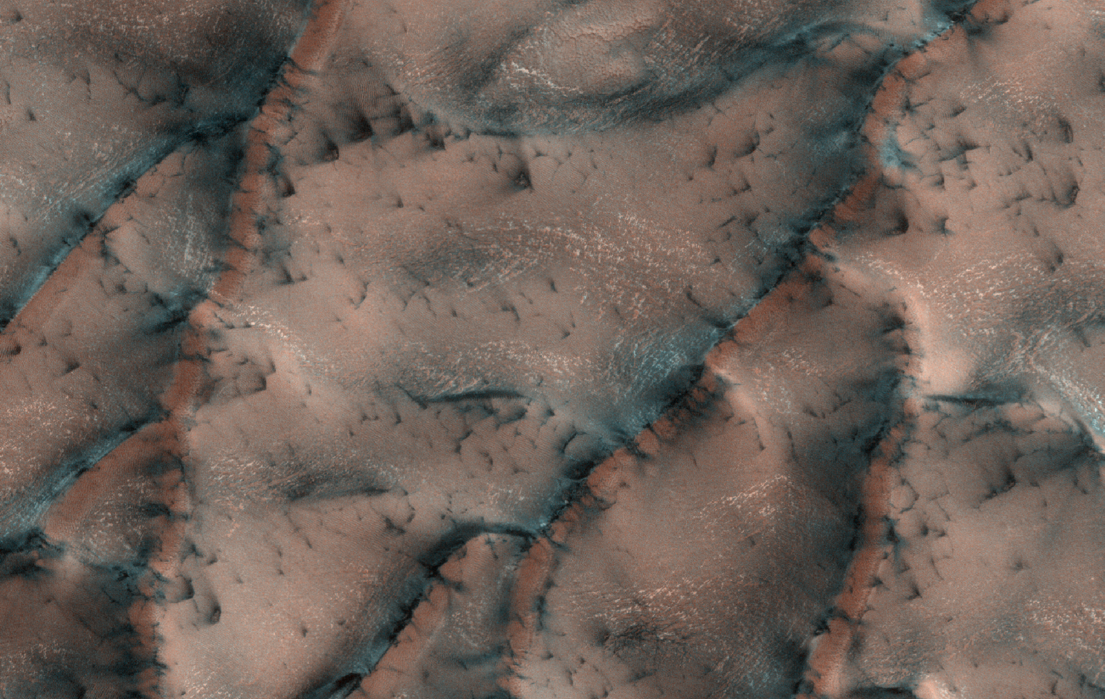
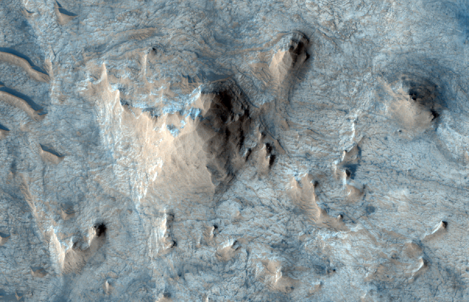
A valley extends across the center of the image, and a tributary joins it from the north, while another branch connects from the south. This branch--which resembles half of a crater--is really just a bend in the channel, much more incised than the muted valley going across the scene.

There is evidence of mass wasting (gravity moving dry materials off high-standing regions onto low-lying regions), visible where a series of ridges appear to be piling up near the floor of the bend.

The terrain surrounding the valley has craters of a range of ages, judging by their different states of degradation. One small fresh crater near the right side of the image has dark, high-standing rays extending from it. A larger more degraded crater is located in the bottom third of the image. A great deal of material has flowed off the crater walls into its center. It is likely that ground ice aided the movement of this material.

Photo credit: NASA/JPL/University of Arizona

Note: The location of this image, Ismenius Lacus, lies in the larger region of Arabia Terra and is located northeast of Cerulli Crater.

Wednesday, December 21, 2011

Radargram of Mars' North Polar Plateau


The upper panel is a radargram profile from the Mars Advanced Radar for Subsurface and Ionospheric Sounding (MARSIS), showing data from the subsurface of Mars in the ice-rich north polar plateau of Mars. It shows layers detected to a depth of about 1.5 miles (2.7 kilometers) beneath the surface in a transect about 930 miles (1,500 kilometers) long. A basal unit of a sand- and dust-rich icy material comprises more than half of the bulk of the polar plateau in this radargram profile. Its base can be traced from beneath the Olympia Undae sand sea at left, across the entire polar stack, to the margin of the Rupes Tenuis plateau at right, where there are no overlying north polar layered deposits (NPLD). The vertical dimension is time delay of radio-signal echo. The apparent deepening of the basal unit's lower boundary at the center is an artifact of the slowing of the radar wave in the icy material. In fact, the lower boundary is nearly flat.

The lower panel shows the path of the spacecraft ground track while these radar observations were being made, on a topographical map derived from Mars Orbiter Laser Altimeter data. Total relief in the topography from highest (red) to lowest (purple) is 1.7 miles (2.7 kilometers).

Image credit: ESA/NASA/JPL-Caltech/Univ. of Rome/ASI/GSFC

Note: For more information, see MARSIS Completes Measurement Campaign Over Martian North Pole.

Monday, December 19, 2011

Faults in Ius Chasma


Ius Chasma is one of many steep-sided interconnected depressions (chasmata) that comprise Valles Marineris, the largest canyon system in the Solar System.

The chasma is approximately 900 kilometers long and is located in western Valles Marineris. The floor of Ius Chasma is between 8 to 10 kilometers deep and is divided by a prominent east-west trending ridge known as Geryon Montes.

The region in this image is located (approximately 7.8 degrees South, 279.5 degrees East) on the floor of Ius Chasma. A variety of light and medium-toned terrains and layered units of different rock types comprise the chasma floor. Prominent faults of various sizes have displaced and deformed these layered units and outcrops, some in a spectacular fashion.

The ejecta of small fresh-appearing impact craters formed in the light-toned units reveal the existence of a darker (likely basaltic) underlying substrate. Linear dunes are located on top of the lighter-tone outcropping units and are ubiquitous on the chasma floor. These dunes are oriented in a north-south direction and indicate prevailing westerly winds through the canyon.

Photo credit: NASA/JPL/University of Arizona

Sunday, December 18, 2011

Fresh Crater North of Tharsis Region


This impact crater is approximately one kilometer in diameter. The ejecta blanket (remnants of the material from the original impact) is still visible indicating that the crater may be very fresh.

But what do we mean by the word "fresh," or even "recent," as some craters are described? When talking about craters on Mars, both terms are relative: the impact that created the crater in this observation could have occurred millions of years ago! We can often differentiate between older and younger craters by looking at their rims. A crater rim that appears more defined or sharp, versus one that is clearly eroded, indicates the former is more recent, or "fresh."

The Tharsis region on Mars is home to some of the largest shield volcanoes on the Red Planet, including the largest, Olympus Mons.

This is a stereo pair with ESP_019140_2310.

Photo credit: NASA/JPL/University of Arizona

Saturday, December 17, 2011

Layering in Central Candor Chasma


This HiRISE image shows faulted layered deposits in a part of Valles Marineris called Candor Chasma.

Often faults cut through the layered material in this area, indicating that the rocks underwent stress causing them to crack and shift in position after they were deposited.

This area also has a high abundance of hematite. Hematite is a mineral that can precipitate out of water, so its presence on Mars is of special interest for understanding the distant past.

Photo credit: NASA/JPL/University of Arizona

Friday, December 16, 2011

Spring Fans Bursting from Cracks in Ice


Sand dunes in the north polar region of Mars are covered every winter by a layer of carbon dioxide ice (dry ice). In the springtime the ice on the dunes cracks, often in polygonal patterns.

Once the ice layer has cracked the sand below can escape. It may be blown downwind, landing in fan-shaped deposits on top of the seasonal layer of ice. It may also slide down the sides of the dunes, often the case when the ice ruptures at the crest of the dune.

Photo credit: NASA/JPL/University of Arizona

Note: This image is located in Olympia Undae to the northeast of Dokka Crater.

Wednesday, December 14, 2011

Crater in Utopia Rupes


The objective of this observation is to examine features of a mid-latitude crater.

In the Context Camera (CTX) image (P18_008030_2217) of this area, the crater floor has hollows and a high density of pits. The wall has the shape of the alcoves of gullies with the lower part covered up. Perhaps this crater once had gullies, but is now filled up.

Photo credit: NASA/JPL/University of Arizona

Note: This crater is located in the Utopia Rupes region of western Utopia Planitia.

Tuesday, December 13, 2011

Meanders and Tributaries in Ridge Form in the Zephyria Region


This observation reveals two obvious features. The smaller, narrow ridges oriented vertically are yardangs, which are created by wind erosion; the wind strips away the surrounding terrain, and the ridges remain because they contain more hardened material.

The second feature—the inverted, meandering channel snaking through the image—is caused by similar processes. This was once a river bed that meandered due to changes in topography. As the river flowed, sediments were deposited on its floor, and over time, these sediments became hardened, so when the wind later stripped away the surrounding terrain, the hardened sediments remained, leaving an inverted form.

Photo credit: NASA/JPL/University of Arizona

Monday, December 12, 2011

Interacting Fossae Segments East of Athabasca Valles


Athabasca Valles starts suddenly along the Cerberus Fossae and flows southwest for approximately 400 kilometers. The source region is divided into two lobes, each roughly centered on the fossae.

Understanding the possible volume and flux of water in the ancient past may help in learning how the flood channel formed.

Photo credit: NASA/JPL/University of Arizona

Sunday, December 11, 2011

Shoemaker Ridge


The feature informally named "Shoemaker Ridge" in the "Cape York" segment of the western rim of Endeavour Crater includes outcrops that are likely impact breccias. Impact breccias are a type of jumbled rock previously examined by NASA's Mars Exploration Rover Opportunity at the "Chester Lake" target on Cape York. The view looks northward toward the southern edge of Shoemaker Ridge.

This image combines exposures taken by Opportunity's Panoramic Camera (Pancam) through three different color filters during the 2,715th Martian day, or sol, of the rover's work on Mars (September 13, 2011). It is presented in false color to emphasize differences among materials in the rock and soil. The filters used are centered on wavelengths of 753 nanometers (near infrared), 535 nanometers (green) and 412 nanometers (violet).

Most of Cape York is covered in densely packed basaltic sands with small embedded rock clasts. Outcrops are exposed particularly on the inboard, or southeast, side of the cape. The name Shoemaker Ridge pays tribute to one of the founding fathers of planetary geology, Eugene Shoemaker.

Photo credit: NASA/JPL-Caltech/Cornell/Arizona State University

Note: An annotated version of the above image can be found here.

Saturday, December 10, 2011

Homestake Vein


This false-color view of a mineral vein called "Homestake" comes from the panoramic camera (Pancam) on NASA's Mars Exploration Rover Opportunity. The vein is about the width of a thumb and about 18 inches (45 centimeters) long. Opportunity examined it in November 2011 and found it to be rich in calcium and sulfur, possibly the calcium-sulfate mineral gypsum.

"Homestake" is near the edge of the "Cape York" segment of the western rim of Endeavour Crater.

Exposures combined into this view were taken through Pancam filters admitting light with wavelengths centered at 753 nanometers (near infrared), 535 nanometers (green) and 432 nanometers (violet). The view is presented in false color to make some differences between materials easier to see.

The exposures were taken during the 2,769th Martian day, or sol, of Opportunity's career on Mars (November 7, 2011).

Photo credit: NASA/JPL-Caltech/Cornell/ASU

Note: For other pictures of Homestake Vein, see PIA15033: 'Homestake' Vein in Color, PIA15035: Close-up View of 'Homestake' Vein, PIA15036: Western Edge of 'Cape York,' with Bright Vein and http://photojournal.jpl.nasa.gov/catalog/PIA15037. Also, see the NASA Science News article, "Slam Dunk" Sign of Ancient Water on Mars.

Update: (3 May 2012) A further discussion of Opportunity at Endeavour Crater and the previously wet climate there (as indicated by the Homestake Vein, shown above) can be found at Paydirt at 8-Year-Old Mars Rover's 'New Landing Site'

Friday, December 9, 2011

Dunes in Vastitas Borealis


This scene is from early spring in the northern hemisphere of Mars. These barchan dunes are covered with a layer of seasonal carbon dioxide ice (dry ice). Bluish cracks in the ice are visible across the top of some of the dunes.

Dark fan-shaped deposits around the edges of the dunes are at spots where the ice has sublimated (gone directly from ice to gas) and the ice layer has ruptured, allowing the sand from the dune to escape out from under the ice. The sand is then free to be blown by the wind.

This image is one product from an observation by the High Resolution Imaging Science Experiment (HiRISE) camera taken on September 30, 2011, at 73.3 degrees north latitude, 355.1 degrees east longitude. Other image products from the same observation are at http://www.uahirise.org/ESP_024265_2535.

Photo credit: NASA/JPL-Caltech/University of Arizona

Tuesday, December 6, 2011

Remnant of Unconformable Deposit in Electris


The Electris region of Mars contains some interesting features, such as the raised-relief blocks of material visible in this image.

One goal of this observation is to try to determine the origin of what's called the "mantling deposit." How was this deposit placed here? What types of geologic processes have acted to form the deposit? An image at high resolution can help provide details on the thickness and subtle variations within this deposit that can give us information on its origin and what erosional processes it has experienced.

This is a stereo pair with ESP_024074_1425.

Photo credit: NASA/JPL/University of Arizona

Note: This image lies in the midst the of the Gorgonum Chaos, which is in Terra Sirenum.

Monday, December 5, 2011

Phlegra Montes


Phlegra Montes is a range of gently curving mountains and ridges on Mars. They extend from the northeastern portion of the Elysium volcanic province to the northern lowlands. The High-Resolution Stereo Camera on ESA’s Mars Express collected the data for these images on 1 June 2011 during orbit 9465. This perspective view has been calculated from the Digital Terrain Model derived from the stereo channels.

Photo credit: ESA/DLR/FU Berlin (G. Neukum)

Note: For more information, see Mountains and Buried Ice on Mars.

Sunday, December 4, 2011

Gullies in Acidalia Planitia


This observation covers gullies that were previously identified in the walls of a crater in a MOC image (E0502675).

Do these gullies have features that can be interpreted as characteristic of snow and/or ice melting? At HiRISE resolution, questions like this can possibly be answered.

HiRISE often re-images areas to track seasonal changes, so we expect to monitor these gullies for changes at intervals during several Mars years.

Photo credit: NASA/JPL/University of Arizona

Note: These gullies are in a crater in Acidalia Planitia, to the northeast of Gamboa Crater.

Saturday, December 3, 2011

Gully and Dunes


An earlier observation (ESP_019969_1215) of the same area shows a very interesting feature: a defrosting gully and dunes, with distinct defrosting spots along the gully channel.

Since HiRISE can re-image certain areas over time, this area seems like a worthwhile place to monitor the defrosting process and hopefully gain a deeper understanding of it. This observation was taken at the end of southern summer and will serve as a baseline for observing the gully defrosting next southern spring.

Photo credit: NASA/JPL/University of Arizona

Note: This image is taken in an unnamed crater southwest of Argyre Planitia.

Friday, December 2, 2011

Bright and Dark Terrain in Noctis Labyrinthus


This image shows the transitional terrain where the linear troughs and rounded pits of Noctis Labyrinthus merge with the larger chasmata of Valles Marineris. Unusual bright blocks can be seen beneath a layered dark mantle.

The bright blocks also have some layering and show hydration features in CRISM spectra. The bright blocks are jagged and irregular in shape, perhaps because they represent impact material or because they are partially obscured beneath a dark mantle so we cannot see their full extent.

The dark mantle consists of aeolian (wind-driven) material (as evidenced by linear ripples) as well as a finely layered unit. The dark layered mantle does not show any hydration features in CRISM spectra so perhaps it represents multiple events of wind deposition where each time this material was laid down it became a distinct layer.

This is a stereo pair with PSP_006692_1740.

Photo credit: NASA/JPL/University of Arizona

Thursday, December 1, 2011

Cross Section of Gale Crater


This artist's impression of Mars' Gale Crater depicts a cross section through the mountain in the middle of the crater, from a viewpoint looking toward the southeast. The rover Curiosity of NASA's Mars Science Laboratory mission will land in Gale Crater in August 2012. The landing area is on or near an alluvial fan indicated in blue. A key factor in selection of Gale as the mission's landing site is the existence of clay minerals in a layer near the base of the mountain, within driving range of the landing site. The location of the clay minerals is indicated as the green band through the cross section of the mountain. The image uses two-fold vertical exaggeration to emphasize the area's topography. The crater's diameter is 96 miles (154 kilometers).

The image combines elevation data from the High Resolution Stereo Camera on the European Space Agency's Mars Express orbiter, image data from the Context Camera on NASA's Mars Reconnaissance Orbiter, and color information from Viking Orbiter imagery.

Image Credit: NASA/JPL-Caltech/ESA/DLR/FU Berlin/MSSS

Wednesday, November 30, 2011

Changes in the Tilt of Mars' Axis


Modern-day Mars experiences cyclical changes in climate and, consequently, ice distribution. Unlike Earth, the obliquity (or tilt) of Mars changes substantially on timescales of hundreds of thousands to millions of years. At present day obliquity of about 25-degree tilt on Mars' rotational axis, ice is present in relatively modest quantities at the north and south poles (top left). This schematic shows that ice builds up near the equator at high obliquities (top right) and the poles grow larger at very low obliquities (bottom) (References: Laskar et al., 2002; Head et al., 2003).

Illustration credit: NASA/JPL-Caltech

Tuesday, November 29, 2011

Topography of Gale Crater


Color coding in this image of Gale Crater on Mars represents differences in elevation. The vertical difference from a low point inside the landing ellipse for NASA's Mars Science Laboratory (yellow dot) to a high point on the mountain inside the crater (red dot) is about 3 miles (5 kilometers).

Image credit: NASA/JPL-Caltech

Monday, November 28, 2011

Eberswalde Crater


Eberswalde crater on Mars formed more than 3.7 billion years ago. The rim of the crater is intact only in the north-eastern part. The rest has been buried by ejecta from the larger, more recent Holden impact crater nearby. The image was acquired by Mars Express around 25°S/326°E during orbit 7208 on 15 August 2009. The images have a ground resolution of about 22m per pixel.

Photo credit: ESA/DLR/FU Berlin (G. Neukum)

Sunday, November 27, 2011

Launch of the Mars Science Laboratory ("Curiosity")

I need to get to bed, but I first wanted to add two videos of the Mars Rover Curiosity launching successfully from Cape Canaveral today. Captions for the videos will come later. This first video is from NASAtelevision:


This second video is a much longer version:

Buried Ice Under Fresh Crater


Recent small craters discovered by the High Resolution Imaging Science Experiment camera on NASA's Mars Reconnaissance Orbiter expose buried ice in the middle latitudes of Mars. This ice is a record of past climate change. Not stable today, it was deposited during a period of different obliquity, or tilt, of the planet's axis.

This image is one product from HiRISE observation ESP_011337_2360.

Photo credit: NASA/JPL-Caltech/Univ. of Arizona

Notes: This crater was formed in 2008. In the larger images of the area taken by HiRISE (see the link above), the crater appears as a tiny white splotch. In the image shown above, the other tiny craters are presumably secondary craters caused by ejecta from the primary (large) impact crater.

Saturday, November 26, 2011

Nirgal Vallis


This view of channels on Mars came from NASA's Mariner 9 orbiter. In 1971, Mariner 9 became the first spacecraft to enter orbit around Mars.

Photo credit: NASA/JPL-Caltech

Note: Obviously, as the note on the photograph mentions, this image is of part of Nirgal Vallis.

Clay Minerals in Mawrth Vallis


Thick stacks of clay minerals indicate chemical alteration of thick stacks of rock by interaction with liquid water on ancient Mars. Aluminum clays overlying iron/magnesium clays here in the ancient terrains of Mawrth Vallis indicate a change in environmental conditions. Aluminum clays may form by near-surface leaching while iron/magnesium clays may form in the subsurface. The image is from the High Resolution Imaging Science Experiment camera on NASA's Mars Reconnaissance Orbiter. (References: Wray et al., 2008; Loizeau et al., 2010.)

Photo credit: NASA/JPL-Caltech/University of Arizona

Friday, November 25, 2011

Sulfates and Clays in Columbus Crater


Sulfates are found overlying clay minerals in sediments within Columbus Crater, a depression that likely hosted a lake in the past. Sulfate salt deposits ring the crater like a bathtub ring and were deposited after the clays, as the lake dried out. The image combines information from two instruments on NASA's Mars Reconnaissance Orbiter, the Compact Reconnaissance Imaging Spectrometer for Mars and the Context Camera. (Reference: Wray et al., 2011.)

Photo credit: NASA/JPL-Caltech/MSSS/JHU-APL

Thursday, November 24, 2011

Topography of Mars


Color coding in this image of Mars represents differences in elevation, measured by the Mars Orbiter Laser Altimeter on NASA's Mars Global Surveyor. While surface liquid water is rare and ephemeral on modern Mars, the topography of Mars reveals large, ancient valley networks and outflow channels. These are evidence that liquid water was more common and played a much more important role in Mars' past.

Image credit: NASA/JPL-Caltech

Note: The view of this map is somewhat unusual; we are looking from the north to the south. The "blue land" to the left is Acidalia Planitia (dark blue) and Chryse Planitia (light blue). The "green land" on the far left limb is Arabia Terra, while the green and yellow land to the middle right is Lunae Planum (lower right) and Xanthe Terra (upper middle right, with the large craters). The long blue and green streak in the "red land" is Valles Marineris; that leads to the various chasmata and chaotic terrains that lie near the top (southernmost) limb of the planet. The green "dogleg" at the bottom right is Echus Chasma (far right) and Kasei Valles (middle right), which flowed into Chryse Planitia.

Monday, November 21, 2011

Moving Sand Dunes in the Martian North Polar Region


A dune in the northern polar region of Mars shows significant changes between two images taken on June 25, 2008 and May 21, 2010 by NASA's Mars Reconnaissance Orbiter. This motion includes landslides and sand advancing at the dune front (upper left); changes in the position of the rest of the dune boundary relative to the fixed, underlying terrain; and changes in the position of ripples on the dune surface.

This is one of several sites where the orbiter has observed shifting sand dunes and ripples. Previously, scientists thought sand on Mars was mostly immobile. It took the mission's High Resolution Imaging Science Experiment (HiRISE) to take sharp enough images to finally see the movement.

While dust is easily blown around the Red Planet, its thin atmosphere means that strong winds are required to move grains of sand.

Photo credit: NASA/JPL-Caltech/University of Arizona/JHUAPL

Note: For an animated GIF file that shows the movement of the sand dunes over time, see here. I am not sure exactly where this image is located other than the very generic "northern polar region," so I am not attempting to link to any specific location.

Sunday, November 20, 2011

Blowing in the Martian Wind


A rippled patch of sand in Becquerel Crater on Mars moved about two meters (about two yards) between November 24, 2006 and September 5, 2010, as observed in these images taken by NASA's Mars Reconnaissance Orbiter. The white line tracks the displacement between two ripples. Becquerel Crater is located just north of the equator in the Arabia Terra region.

This is one of several sites where the orbiter has observed shifting sand dunes and ripples. Previously, scientists thought sand on Mars was mostly immobile. It took the mission's High Resolution Imaging Science Experiment (HiRISE) to take sharp enough images to finally see the movement.

While dust is easily blown around the Red Planet, its thin atmosphere means that strong winds are required to move grains of sand.

Photo credit: NASA/JPL-Caltech/University of Arizona/JHUAPL

Note: For an animated GIF file that shows the movement of the sand over time, see here.

Saturday, November 19, 2011

MAVEN


This artist's concept depicts NASA's Mars Atmosphere and Volatile EvolutioN (MAVEN) spacecraft near Mars. MAVEN is in development for launch in 2013 and will be the first mission devoted to understanding the Martian upper atmosphere. The mission's principal investigator is Bruce Jakosky from the Laboratory for Atmospheric and Space Physics at the University of Colorado.

The goal of MAVEN is to determine the role that loss of atmospheric gas to space played in changing the Martian climate through time. MAVEN will determine how much of the Martian atmosphere has been lost over time by measuring the current rate of escape to space and gathering enough information about the relevant processes to allow extrapolation backward in time.

Illustration credit: NASA

Rippling Dune Front in Herschel Crater


A rippled dune front in Herschel Crater on Mars moved an average of about two meters (about two yards) between March 3, 2007 and December 1, 2010, as seen in these images from NASA's Mars Reconnaissance Orbiter. Note that the pattern of ripples on the dune surface has changed completely between the two images. Herschel Crater is located just south of the equator in the cratered highlands.

This is one of several sites where the orbiter has observed shifting sand dunes and ripples. Previously, scientists thought sand on Mars was mostly immobile. It took the mission's High Resolution Imaging Science Experiment (HiRISE) to take sharp enough images to finally see the movement.

While dust is easily blown around the Red Planet, its thin atmosphere means that strong winds are required to move grains of sand.

Photo credit: NASA/JPL-Caltech/University of Arizona/JHUAPL

Notes: For an animated GIF file that shows the movement of the dune over time, see here. Also, for more pictures, including animated GIFs of shifting sand dunes in Herschel Crater, see PIA14877: Shifting Sand in Herschel Crater and PIA14879: Rippling Dune Front in Herschel Crater on Mars.

Wednesday, November 16, 2011

Wrinkle Ridges in Eastern Meridiani Planum


This wrinkle ridge crosses through a mound of layered material that's been exposed by erosion.

This observation poses an excellent opportunity to look at the internal structure of a wrinkle ridge. We can compare the topography and internal structure of this wrinkle ridge at this location to exposures in other terrain to see if the local bedrock has a noticeable effect on ridge morphology or growth.

The layers also represent stratigraphic markers that we know were once continuous - examining faults that cross-cut and offset layers can yield good information about the amount and direction of movement that took place along that fault.

This is a stereo pair with ESP_020850_1845.

Photo credit: NASA/JPL/University of Arizona

Note: This image is located in eastern Meridiani Planum; the closest named feature to this site is Schiaparelli Crater to the southeast.

Tuesday, November 15, 2011

Light-Toned Layered Rocks in Arabia and East Xanthe Regions


The banding in this image has been interpreted based on MOC images to be layering. A critical goal of this observation is to provide points of comparison with HiRISE full resolution coverage and CRISM infrared spectra of light-toned rock outcrops in other areas of the Mawrth Vallis region.

The dark terrain at the north end of the image is heavily cratered and has thus been there (at the surface) longer than the brighter terrain in the rest of the image. But is it older, as heavily cratered terrain often indicates?

The dark terrain appears to be higher in elevation, which in layered terrain usually means that it is actually younger than the bright terrain (lower layers are deposited first). One possibility is that the bright terrain used to be covered with the darker material also, but that that darker material has been stripped off and removed, revealing the brighter layers and terrain below. If this is indeed the case, then the low bright terrain could actually be older and it has fewer craters only because it has been more recently exposed to the surface. Clues to this are small high-standing knobs throughout the bright terrain that could be remnants of once more-widespread higher topography.

Also, the larger circular to oval patches, or "islands" of smooth dark material within the bright material are also high-standing. They may be old impact craters, exterior to which erosion has removed dark terrain, but interior to which the crater walls or some hardening process has protected the dark terrain from erosion. Such terrain is called "inverted topography" because a crater depression which was once empty and low has become filled, and the material outside of the crater has been removed while the material inside the crater hasn't - producing relief opposite to that of the original landscape.

Photo credit: NASA/JPL/University of Arizona

Monday, November 14, 2011

Gullies and Lobate Material in a Crater in the Nereidum Montes


This image includes a crater that has been heavily influenced by later geologic processes.

First of all, terrain-altering or -burying processes have eliminated much of the pattern of ejecta that surrounds fresh craters. The crater also appears fairly flat-floored with short walls (not very deep) for its size, indicating material has filled it in. These modifying effects may be due to deposition and activity of ice-rich or other mantling sediments deposited at some point in the past.

Finally, the crater clearly exhibits gullies starting on its northern wall and extending to its center. The arc-shaped ridge inside the southern edge of the crater, partially buried by the filling material, is particularly curious - it could be a wind-caused or other accumulation of crater-fill material.

One of the rationales for acquiring an image of this location is to investigate the relationship between these features; HiRISE's full resolution can provide better details of the terrain.

Photo credit: NASA/JPL/University of Arizona

Note: This crater lies in the Nereidum Montes, which is the mountainous terrain to the northwest of Argyre Planitia.

Sunday, November 13, 2011

Tharsis Tholus


Tharsis Tholis towers 8 km above the surrounding terrain with a base that stretches 155 x 125 km and a central caldera measuring 32 x 34 km. The image was created using a Digital Terrain Model (DTM) obtained from the High Resolution Stereo Camera on ESA’s Mars Express spacecraft. Elevation data from the DTM is color-coded: purple indicates the lowest lying regions and beige the highest. The scale is in meters. In these images, the relief has been exaggerated by a factor of three.

Photo credit: ESA/DLR/FU Berlin (G. Neukum)

Note: For more information (and a lot of other, great images), see Battered Tharsis Tholus Volcano on Mars.

Saturday, November 12, 2011

Mars Science Laboratory atop the Atlas V


In the Vertical Integration Facility at Space Launch Complex 41, the payload fairing containing NASA's Mars Science Laboratory spacecraft was attached to its Atlas V rocket on November 3, 2011.

The spacecraft was prepared for launch in the Payload Hazardous Servicing Facility at NASA's Kennedy Space Center. Its components include a car-sized rover, Curiosity, which has 10 science instruments designed to search for evidence about whether Mars has had environments favorable to microbial life, including the chemical ingredients for life.

Launch of the Mars Science Laboratory aboard a United Launch Alliance Atlas V rocket is planned for November 25 from Space Launch Complex 41 on Cape Canaveral Air Force Station.

Photo credit: NASA

Note: For other pictures showing Curiosity being prepared for launch, see:
* PIA15020: Mars Science Laboratory Descent Stage
* PIA15021: Mars Science Laboratory Rover Closeout
* PIA15022: Mars Science Laboratory Powered Descent Vehicle
* PIA15023: Integrating Powered Descent Vehicle with Back Shell of Mars Spacecraft
* PIA15026: Mars Science Laboratory Cruise Stage
* PIA15027: Mars Science Laboratory Heat Shield Integration for Flight
* PIA15028: Mars Science Laboratory Stacked Spacecraft
* PIA15029: Mars Science Laboratory and Its Payload Fairing
* PIA15030: Hoisting NASA's Mars Science Laboratory Onto Its Atlas V

Friday, November 11, 2011

Lava Coating, Flood-Carved Kasei Valles


This HiRISE image covers a small part of the gigantic 1,780 kilometer (1,100 mile long) set of flood-carved channels on Mars called Kasei Valles. The focus of this image is a much narrower channel that was cut into the floor of the large channel system.

It is interesting to compare this lava-coated channel to a similar feature called Athabasca Valles. Both channels appear to have been cut by a flood of some fluid, and then coated with a thin layer of lava. In the case of Athabasca Valles, the fluid that carved the channel and the lava came out of the same fissure in the ground. Every channel is completely coated with lava, allowing the possibility that Athabasca Valles was carved by lava.

However, at Kasei Valles, the lava and the flood carving fluid came from two different places. The valleys were carved by floods, presumably of very muddy water, released from Echus Chasma. The lava in Kasei Valles only coats the lowermost part of the huge valleys and comes from a source between the huge Tharsis volcanoes.

As HiRISE collects more images, we are able to expand our understanding of Mars by comparing and contrasting key features.

Photo credit: NASA/JPL/University of Arizona

Monday, November 7, 2011

Avalanche at Olympia Rupes


Since HiRISE first started finding avalanches on Mars, we have continued searching for them in the most likely places: steep cliffs at the edges of the layered deposits at the North Pole.

These layers are exposed in the scarp face that cuts through them diagonally across this subimage. The bright smoother material at the lower left is at the top of the cliff, and here we have caught another avalanche as it falls down the steep slope towards the upper right of the image.

A large (approximately 200 meters or 600 feet across) cloud of reddish dust has been kicked up at the base of the scarp. Fine tendrils of bright wisps are visible farther up the cliff face—these may be individual falls of material, before spreading out as the avalanche plummets downward.

This might allow scientists to figure out the exact location of the start of the avalanche; for example, which layer it originally came from and how far it fell. This information will help narrow down what triggers these falls: is it seasonal temperature changes in the ice layers, gusts of wind passing over loosened rocks in steep slopes, or something else entirely?

In the upcoming season of spring in the northern hemisphere, HiRISE will be searching for even more of these events in order to better understand when and where they happen, and why.

Photo credit: NASA/JPL/University of Arizona

Note: The above image is taken along the long Olympia Rupes that is at the edge of Planum Boreum. The closest named feature is Puyo Crater, which lies to the southwest of this image.

Sunday, November 6, 2011

Rafting Rocks


This image shows some interesting features where smoother, dark areas with straight sides are separated by narrow channels of higher material.

This is especially clear in the southern portion of the image (rotated so north is at approximately 11 o'clock, 3.2 kilometers or 2 miles across). It looks as if a flat solid surface broke up, and then the individual pieces were rafted apart.

In other areas of Mars, similar features formed when a layer of lava solidified on top of still-molten rock. The solid layer at the surface broke apart either when it contracted as it cooled, or when the liquid below it flowed and dragged along the bottom of the top layer of solid rock.

However, this area of the Hellas basin is not expected to have any volcanic activity. Hellas is a huge, old impact crater, filled with sediments and heavily eroded. In addition, there are subtle differences in the textures here that make this look different from the plate-like lava we find in other areas of Mars. Instead, perhaps something similar happened, but with a mixture of ice and rock instead of lava.

It's possible that a freezing mudflow was pulled apart here, with a frozen upper layer breaking and rafting apart on top of slushy material. When the underlying slushy ice later froze, it would have expanded and been squeezed up between the plates, creating the raised ridges between them.

Photo credit: NASA/JPL/University of Arizona