
Some of the youngest volcanic flows on Mars are from Arsia Mons. This VIS image of Daedalia Planum shows some of these flows.
Photo credit: NASA/JPL/Arizona State University
Some of the youngest volcanic flows on Mars are from Arsia Mons. This VIS image of Daedalia Planum shows some of these flows.

This observation shows a part of a central mound in an impact crater in Arabia Terra. At low resolution, the mound is relatively smooth and featureless, although elsewhere in the mound a Mars Orbiter Camera (MOC) image shows fine layers.
The mound is broad, filling much of the crater, although it now appears to be eroding. Images like this can be used to explore the nature of the deposit, and provide clues about how it formed. At high resolution the material still appears relatively uniform and featureless, without boulders or obvious fine layers. This indicates a relatively weak, fine-grained material.
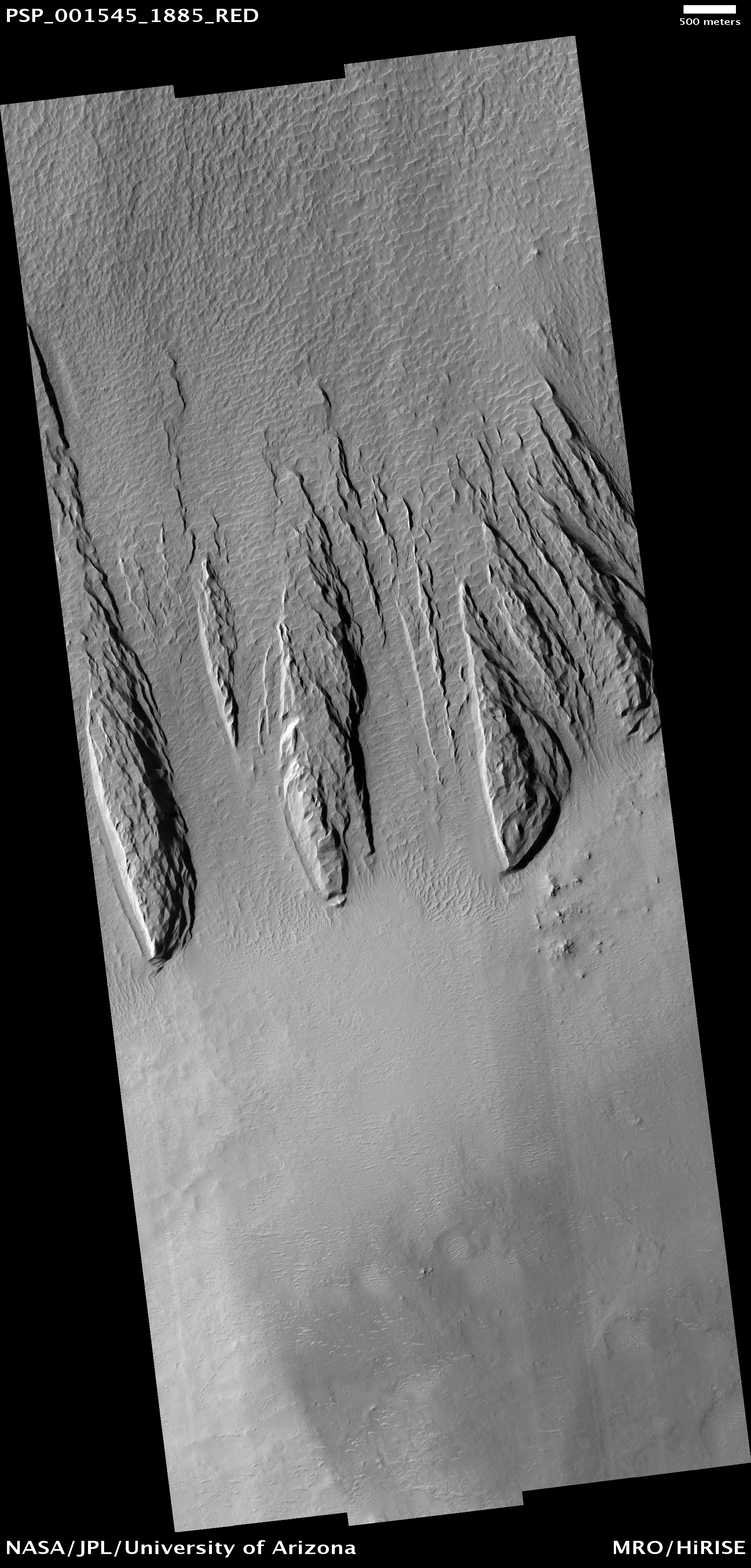
The large, elongated features in the image are yardangs. These are characteristic of aeolian (wind) erosion. They form roughly parallel with the direction of the prevailing wind, and the streamlined shape (often compared with the hull of a boat) is created by persistent flow from this direction.
Yardangs on Earth often form from relatively unconsolidated material, supporting the inference made from the appearance of the deposit.

This VIS image shows a small portion of Auqakuh Vallis.

There is a vast region of sand dunes at high northern latitudes on Mars. In the winter, a layer of carbon dioxide ice covers the dunes, and in the spring as the sun warms the ice it evaporates. This is a very active process, and sand dislodged from the crests of the dunes cascades down, forming dark streaks.
In the subimage falling material has kicked up a small cloud of dust. The color of the ice surrounding adjacent streaks of material suggests that dust has settled on the ice at the bottom after similar events.
Also discernible in this subimage are polygonal cracks in the ice on the dunes (the cracks disappear when the ice is gone).

These sand dunes are located on the floor of McLaughlin Crater.

Extensive radar mapping of the middle-latitude region of northern Mars shows that thick masses of buried ice are quite common beneath protective coverings of rubble.
The ability of NASA's Mars Reconnaissance Orbiter to continue charting the locations of these hidden glaciers and ice-filled valleys -- first confirmed by radar two years ago -- adds clues about how these deposits may have been left as remnants when regional ice sheets retreated.
The subsurface ice deposits extend for hundreds of kilometers, or miles, in the rugged region called Deuteronilus Mensae, about halfway from the equator to the Martian north pole. Jeffrey Plaut of NASA's Jet Propulsion Laboratory, Pasadena, California, and colleagues prepared a map of the region's confirmed ice for presentation at this week's 41st Lunar and Planetary Science Conference near Houston.
The Shallow Radar instrument on the orbiter has obtained more than 250 observations of the study area, which is about the size of California.
"We have mapped the whole area with a high density of coverage," Plaut said. "These are not isolated features. In this area, the radar is detecting thick subsurface ice in many locations." The common locations are around the bases of mesas and scarps, and confined within valleys or craters.
Plaut said, "The hypothesis is the whole area was covered with an ice sheet during a different climate period, and when the climate dried out, these deposits remained only where they had been covered by a layer of debris protecting the ice from the atmosphere."
The researchers plan to continue the mapping. These buried masses of ice are a significant fraction of the known non-polar ice on Mars. The ice could contain a record of environmental conditions at the time of its deposition and flow, making the ice masses an intriguing possible target for a future mission with digging capability.

This VIS image shows a portion of the floor of Melas Chasma. Wind blown material is located in lows between layered floor materials.

The deep pits on the flanks of Arsia Mons have attracted special interest because some are potentially linked to subterranean caverns. Such locations would be protected from the radiation, impacts, and extreme temperature variations seen at the surface of Mars and therefore could be more favorable for life (including future human explorers).
The three pits seen in this area are in a line, suggesting that they all formed in response to the same underground feature. One possibility is a lava tube, but lava tubes tend to have bends and curves. Furthermore, HiRISE shows that there are multiple layers exposed in the walls of the pits. While it is perfectly possible for skylights into lava tubes to cut through multiple lava flows, this is not the most common case (usually they cut through just the top of a single flow). Hence it is more likely that these pits overly a fault system where the ground is being pulled apart.
In places the ground has collapsed into the resulting void, producing these pits. Such faults are expected as the great weight of these giant volcanoes slowly tears them apart. Similar faults and pits are found on many of Earth's volcanoes, with Kilauea Volcano on Hawaii being perhaps the best studied example.

This VIS image shows secondary channeling on a terrace of the huge Kasei Valles outflow system.

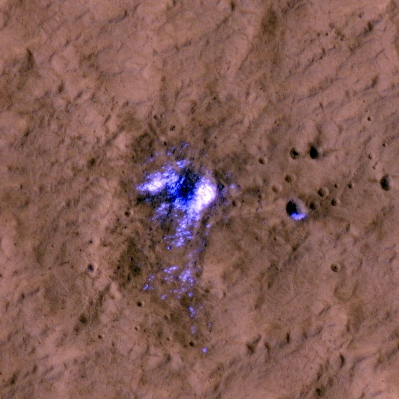
Newly formed impact craters have been discovered on Mars over the past several years. When craters form over dusty regions the impact blast blows the bright dust off the terrain over a wide area, leaving a dark spot.
These large dark spots are visible to the Context Camera (CTX) and the Context Camera team reports their discovery to the HiRISE team. HiRISE has sufficient resolution to see not only the dark blast zone, but also the much smaller crater that formed it. One of these craters, with its dark blast zone, is visible in the first subimage. The blast zone is almost 800 meters (half a mile) across. The crater itself is just over 20 meters (66 feet) across and is shown in the second subimage.
This crater is one of a special group that have excavated down to buried ice. This ice gets thrown out of the crater onto the surrounding terrain. Although buried ice is common over about half the Martian surface, we can only easily discover craters in dusty regions. The overlap between areas that both have buried ice and surface dust is unfortunately small. So even though we have discovered over 100 new impact craters we have only discovered 7 new craters that expose buried ice.
When craters excavate this buried ice it tells us something about the extent and depth of buried ice on Mars (controlled by climate); this information is used by planetary scientists to figure out what the recent climate of Mars was like. It has also been a surprise that this ice is so clean. Scientists expected this buried ice to be a mixture of ice and dirt; instead this ice seems to have formed in pure lenses. Yet another surprise that Mars had in store for us!

Melas Chasma is the central portion of Valles Marineris. This VIS image shows a small portion of the floor of Melas Chasma, including layered deposits and wind eroded and deposited materials.

The lower flanks of Arsia Mons, one of the giant volcanoes on Mars, is riddled with pits of various sizes. These have been of great interest to a number of researchers because they have the potential to be openings into underground caverns.
Such caverns have some potential for holding ice and offer protection from radiation and small meteorites. These are good things if one is looking for a safe place for current life on Mars or future human life.
However, this image shows some of the pitfalls of such hopes. Most of these pits are largely filled with rubble and dust that hide any potential links to larger underground areas. Furthermore, the entrances are steep and rocky, making them difficult areas to traverse. They would be a very exciting, if not safe, place to visit!

Wind is one of a handful of active processes on Mars today. This VIS image of Memnonia Sulci demonstrates the power of wind in eroding and shaping the surface.

This observation was taken to see if the cluster of pits were formed by the interaction of hot lava with water. Such pits and cones have been found in this region, most likely because there was significant ice in the ground when a large lava flow inundated the area.
However, in this case, HiRISE reveals that the circular features are a mass of impact craters (note that the word "crater" is used by geologists for holes formed by volcanic, impact, and other geologic processes). The tight clustering of these craters is unusual. The most likely explanation is that they were formed by a clump of material thrown out from a larger impact crater nearby. As such, they are called "secondary" craters with the larger source crater called a "primary". This HiRISE image covers too small an area to identify the primary.

This VIS image of Terra Cimmeria shows channeling and dunes near Herschel Crater.

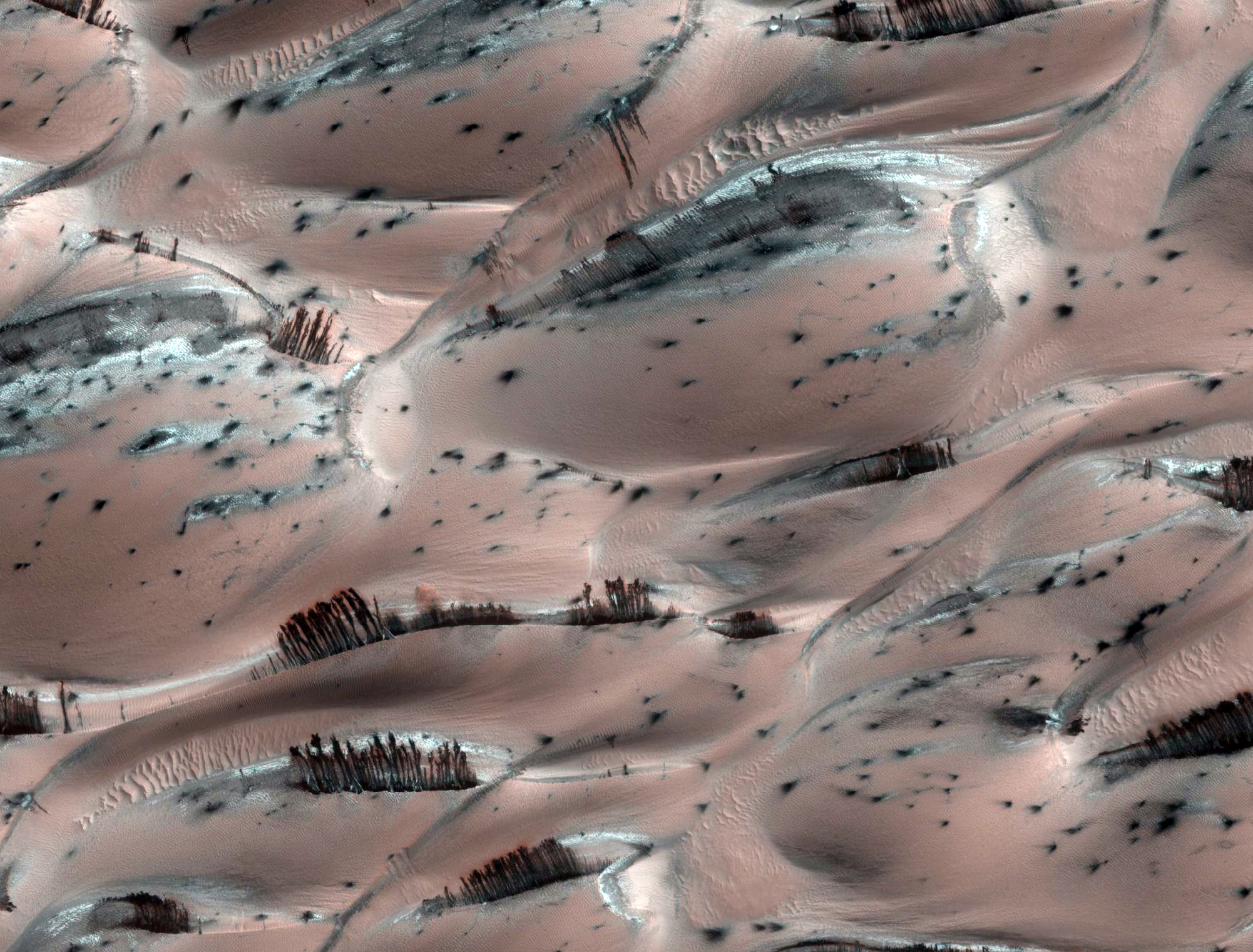
The south polar layered deposits are a stack of layered ice up to 3000 meters (9800 feet) thick which is similar to terrestrial ice sheets. In places, this stack extends up to 1100 kilometers (680 miles) from the pole and many of the impact craters surrounding this ice-sheet appear to be filled with mounds of similar icy material and also sand dunes.
This image shows the material within one of these near-polar craters. The crater is about 44 kilometers (27 miles) across and contains a mound of material about 23 kilometers (14 miles) across and 300 meters (1000 feet) thick on its northern (south facing) wall. The dark material at the top (north) of the image shows the northern wall of the crater, the bright material that begins near the image top and extends toward the bottom is the surface of the mound.
This surface is covered with sand dunes that appear bright as they are still covered by seasonal carbon dioxide frost. Smaller dunes and ripples can be seen on the surfaces of the larger linear dunes. In the low lying areas between dunes, one can see a network of cracks that are reminiscent of the surface of the polar layered deposits, indicating that this mound is probably mostly ice with a thinner and incomplete covering of dunes.
The dark spots in the frost cover are characteristic of how this terrain defrosts, and are commonly observed in these locations during this season.

The image shows an area in the Warrego Valles region. It was collected July 6, 2003 during the northern summer season. The local time is 5 p.m. The image shows multiple channels dissecting the terrain.

One of the most well-known valley networks on Mars is Warrego Valles. Located along the southern boundary of the Thaumasia Plateau in the southern highlands, images of these valley systems are often used in textbooks or online as evidence for a more Earth-like climate on early Mars.
At least before the HiRISE era, whenever a single image illustrating "water on Mars" was needed, a Viking-era image of Warrego answered the call. Despite its fame, the origin of the Warrego valley networks has never been fully understood.
At first glance, these ancient (several billion years old) valley systems seem similar to erosional networks on Earth, but they are simpler and not as finely integrated. In addition, they are only located in one area on the plateau boundary. Valleys have not formed all along the plateau boundary as might be expected from rainfall (Gulick, 2001, Geomorphology, pgs. 241-268). Nevertheless many have argued that these features attest to an ancient warmer, wetter time of Mars' geological history. To better understand the Warrego valleys, HiRISE imaged the headwater regions of one of the tributaries.
Seen at high resolution the system appears more complex than implied by the much lower resolution Viking-era images. The valley floor — as well as the floors of nearby small craters — is covered by an enigmatic rough, angular, blocky textured material that seems to be contained in a finer-grained material. This rough textured material might also be the result of ice evaporating from the subsurface.
At any rate, at HiRISE resolution, there is little sign of fluvial bedforms, like channel bars, from the original erosive event that carved the valleys. Given the age of these valleys, clues to its origin may long since have been obscured by subsequent geologic processes. Without such geologic clues we can add little more to the previous speculation about what might have carved these features originally. In this case, the high resolution images provided by HiRISE inform us that we have much more to learn about some of the best known landforms on Mars.

This VIS image of dunes in the north polar region was collected in early spring. Frost still covers the dunes.

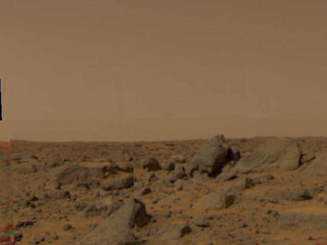
NASA's Mars Exploration Rover used its panoramic camera to record this view of the rim of a crater about 65 kilometers (40 miles) in the distance, on the southwestern horizon. This crater, Bopolu, is about 19 kilometers (12 miles) in diameter.
The image was taken during the 2,179th Martian day, or sol, of Opportunity's mission on Mars (March 11, 2010), two days after the rover drove southward away from Concepción Crater, site of several weeks of investigation.
Opportunity's long-term destination is Endeavour Crater, to the southeast and closer than Bopolu. The intended route heads south before turning east in order to bypass potentially hazardous sand ripples to the east, larger than the ripples in the foreground of this image.
This approximately true-color view combines three exposures taken through filters admitting wavelengths of 750 nanometers, 530 nanometers and 480 nanometers.

Dark slope streaks, like the ones in this unnamed crater in Terra Sabaea, are believed to be formed when surface dust is displaced and the darker rock below is exposed. Rocks falling due to gravity likely formed these streaks.

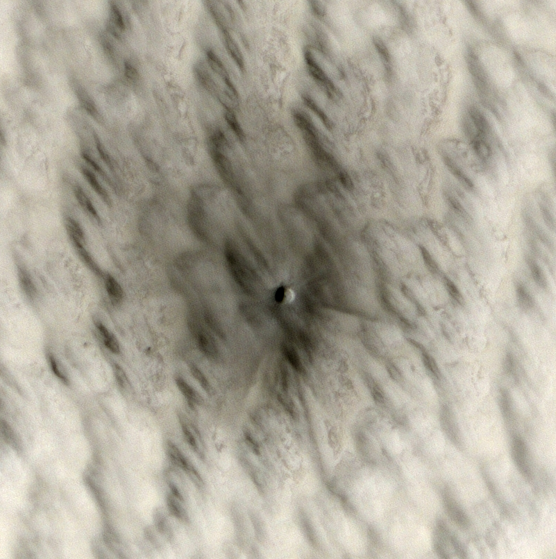
This small crater (approximately 7 meters, or 20 feet, in diameter) was created sometime within the last five years. We know this because we have enough images of Mars over the last decade that we can narrow down its formation date using "before" images where the crater did not appear.
We are able to discover these new craters because the dark area surrounding them is much larger than the crater itself. We can detect this larger dark spot with lower-resolution data sets from other instruments. Then when HiRISE follows up, the higher resolution image reveals the crater at the center of the dark spot, as well as details of the ejecta and surrounding area.
Studying new craters like these will tell us more about the current rate of impacts on Mars. A common technique for estimating the age of a given surface involves counting how many craters of each size are present on that surface. This will help us better understand results from that technique, and refine it to give more accurate ages.
Small impacts like these also represent a hazard to future exploration, both on Mars and the Moon. Imagine if one of the Martian rovers had been at this spot when this object blasted into the surface! This may be a very small crater on planetary scales, but it could still cause a lot of damage. On the Moon, where there is no atmosphere to provide protection from even the tiniest micrometeorite, the danger would be even higher. Knowing the rate of impacts like these will tell us how much shielding will be needed for future landers, rovers, and eventually human explorers.
Be sure to check out one of many more new craters HiRISE is discovering.

This VIS image shows a portion of the floor of Coprates Chasma. Note the sand dune forms near the southern cliff face.

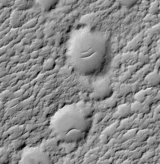
The subimage shows two craters on Mars that are reminiscent of the Greek muses of comedy and tragedy.
The muse of tragedy, Melpomene, wore the sad mask, and the muse of comedy, Thalia, wore the happy mask. Martians probably never enjoyed the theater, or were influenced by the Greeks.
A more likely explanation for the features seen here is that sand was blown into these craters and collected into dunes on their floors, where the winds are less intense.

Dark slope streaks mark this crater rim. This crater is located within the much larger Tikhonravov Crater in Arabia Terra.

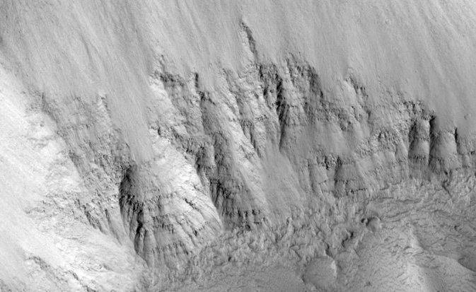
This observation shows the complex, gullied western wall of a kilometer-deep impact crater in the Terra Sirenum region. This is an interesting crater because it appears to be mantled by the fluidized ejecta blanket of a slightly smaller crater just to the west.
A diverse set of gullies originate at multiple elevations along the crater wall. Prominent gullies have incised through the overlying ejecta into the upper walls to reveal numerous resistant dark layers. The floors of these gullies display a host of interesting features, including braided middle reaches, cut banks, channel bars, and stream terracing. These are all features suggestive of water flow.
Miniature gully systems, less than a kilometer long, start much further downslope than the larger gullies yet display the usual gully attributes, including theater-headed alcove source regions, incised middle reaches, and overlapping alluvial fans at their lower reaches. Detailed studies of these and other gully systems should help to elucidate the gully formation mechanisms.

This VIS image shows the southeastern flank of Hecates Tholus, the northernmost volcano of the Elysium Volcanic complex.

This image, near the southeast rim of Peneus Patera crater, is marked by depressions in the mantle with scalloped edges. Several of the depressions have apparently coalesced together.
These features are most commonly found at approximately 55 degrees North and South latitude. Their presence has led to hypotheses of the removal of subsurface material, possibly interstitial ice by sublimation (evaporation).
Steep scarps consistently face the south pole while more gentle slopes face in the direction of the equator. This is most likely due to differences in solar heating.
A polygonal pattern of fractures, commonly associated with "scalloped terrain," can be found on the surface surrounding and within the depressions. The fractures indicate that the surface has undergone stress that may have been caused by subsidence, desiccation, or thermal contraction.
Scallop formation is believed to be an ongoing process at the present time.

The northern part of Terra Sabaea is heavily fractured and channeled, breaking up into a chaotic terrain as the elevation drops down to the northern plains. This VIS image shows just one of the many channels located in the region.

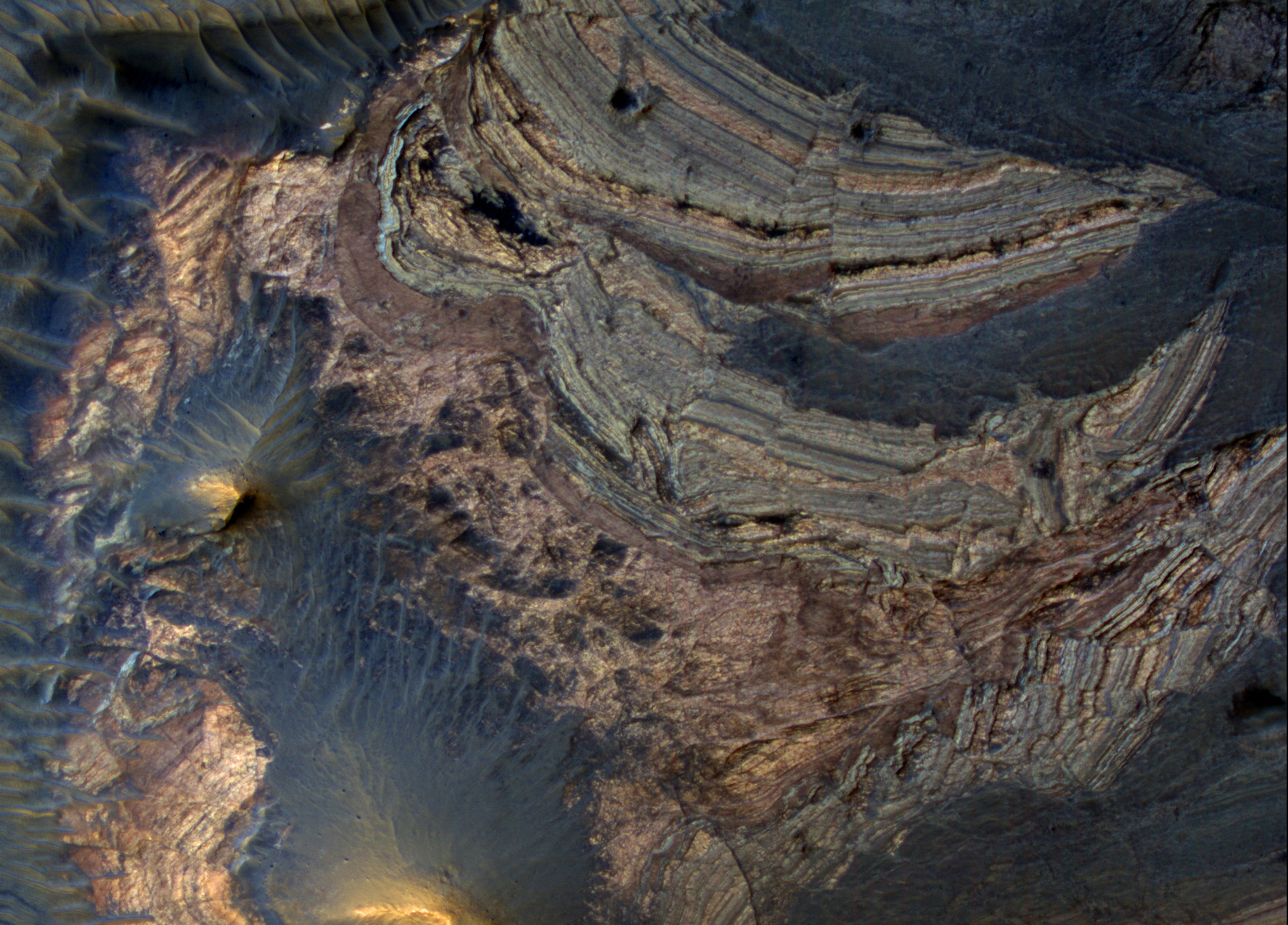
The layers seen in this HiRISE subimage of Echus Chasma are very different from the light-toned, thinly bedded layers HiRISE has observed in deposits seen elsewhere in Valles Marineris.
The view of these layers in Echus Chasma shows they are rough, with knobs of rock sticking out through the dust and talus (loose debris) on the slope. This indicates that perhaps these layers are made of different materials than the light-toned deposits, which appear more friable in nature.
These rough layers may be exposures of lavas, or they might just be more resistant forms of sedimentary rocks. The layers are typical of those seen in chasma slopes and crater rims elsewhere on the Martian surface.

This VIS image of Ganges Chasma contains both landslide deposits and dunes.

This image shows a small shield volcano in the eastern Tharsis region of Mars. The Tharsis region is located on the Martian equator and contains some of the solar system's largest volcanoes.
The oval shaped depression in the center of the image is the summit pit of the volcano. Emanating from the summit crater, is a raised, leveed lava channel that branches downhill. Lava channels are narrow pathways through which lava flows on the volcano surface. The volume of lava in the channel can often fluctuate and sometimes lava will overflow the channel. When this happens, lava congeals and cools along the edges of the channel forming natural levees and building up the lava channel above the surrounding surface.
Shield volcanoes have shallow-sloping sides and get their name from their resemblance to a warrior's shield. They form from basaltic lava that flows easily, or has a low viscosity, and builds up over time to form a broad shield volcano profile.
Some of the largest volcanoes on Earth, such as Mauna Loa and Mauna Kea of Hawaii, are shield volcanoes.

This VIS image shows the western edge of the summit caldera of Ceraunius Tholus, one of the smaller volcanic constructs of the Tharsis region. Several channels dissect the western flank of the volcano.

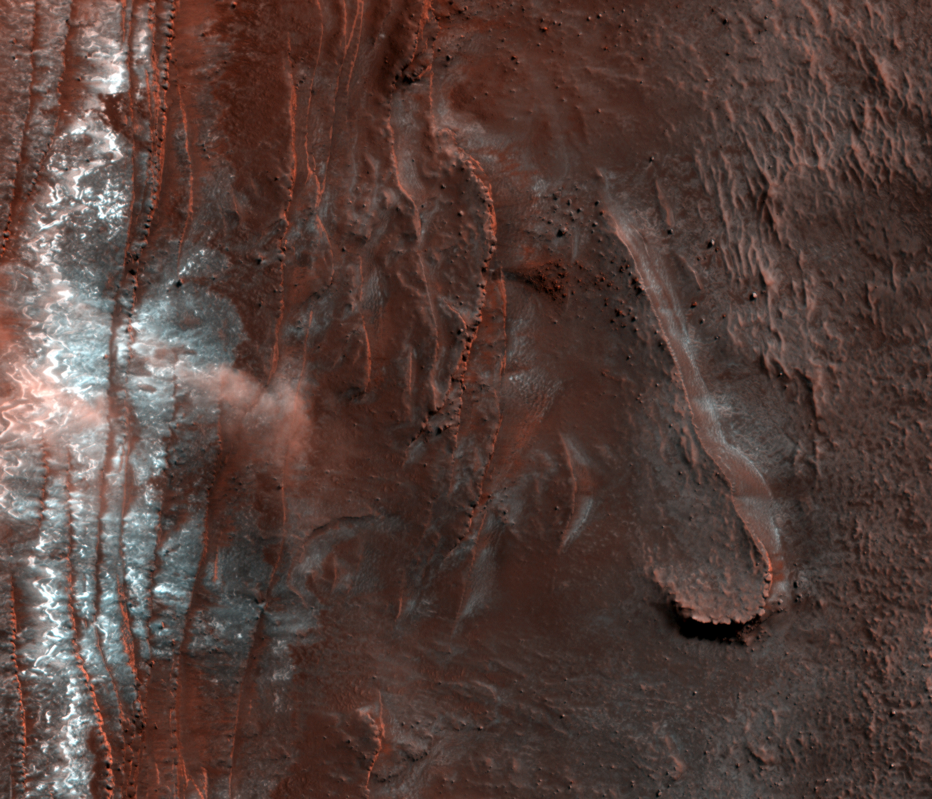
This HiRISE image shows at least three isolated clouds of particles near a steep cliff in the northern polar region of Mars.
These clouds, rolling or hovering close to the ground yet reaching up tens of meters high (up to 180 feet), are likely the result of an avalanche or fall of mostly carbon-dioxide frost. The frost clings to the scarp in the darkness of winter and may be disrupted by sunlight and thermal processes with the coming of spring. The cliff, approximately 700 meters (2000 feet) high is made up of layers of water ice with varying dust content, roughly similar to the polar ice caps on Earth.
On top is bright white carbon-dioxide ice and frost. Last year, HiRISE was monitoring this area for changes in frost patterns as spring progressed - it was quite surprising and very exciting to find an avalanche in progress (e.g. PSP_007338_2640)! This year, we were ready to capture more.
Targeting this scarp as well as others around the edge of the north polar icy layered deposits will help determine if this process is a characteristic one in Mars' cycle of seasons, including the period of year it is active and how wide-spread around the region it is. Several such events occurred earlier this year at this same scarp (e.g. ESP_016173_2640), and several more were also seen at a few other scarps (e.g. ESP_016228_2650) spread around about one-third of the circumference of the polar region.
Looking at all of the individual instances of avalanches from all of the images will also allow us to piece together a sequence of snaphots of the whole avalanche process, from beginning (a stream of material falling down the cliff face) to end (lingering puffy clouds). Based on this year's observations, these events happen mostly in the middle of spring, roughly equivalent to April to early May on Earth. And, they are indeed more widespread than just this one scarp. All together, it seems this is a regular spring process at Mars' north pole that may be expected every year - avalanche season! This information, in conjunction with the results of numerical modeling of the behavior of the materials involved, will help us find out what is causing these dramatic events.

This VIS image of Candor Chasma contains eroded deposits of material and a large landslide deposit. Gravity, wind, and water all played a role in shaping the landforms we see in this image.

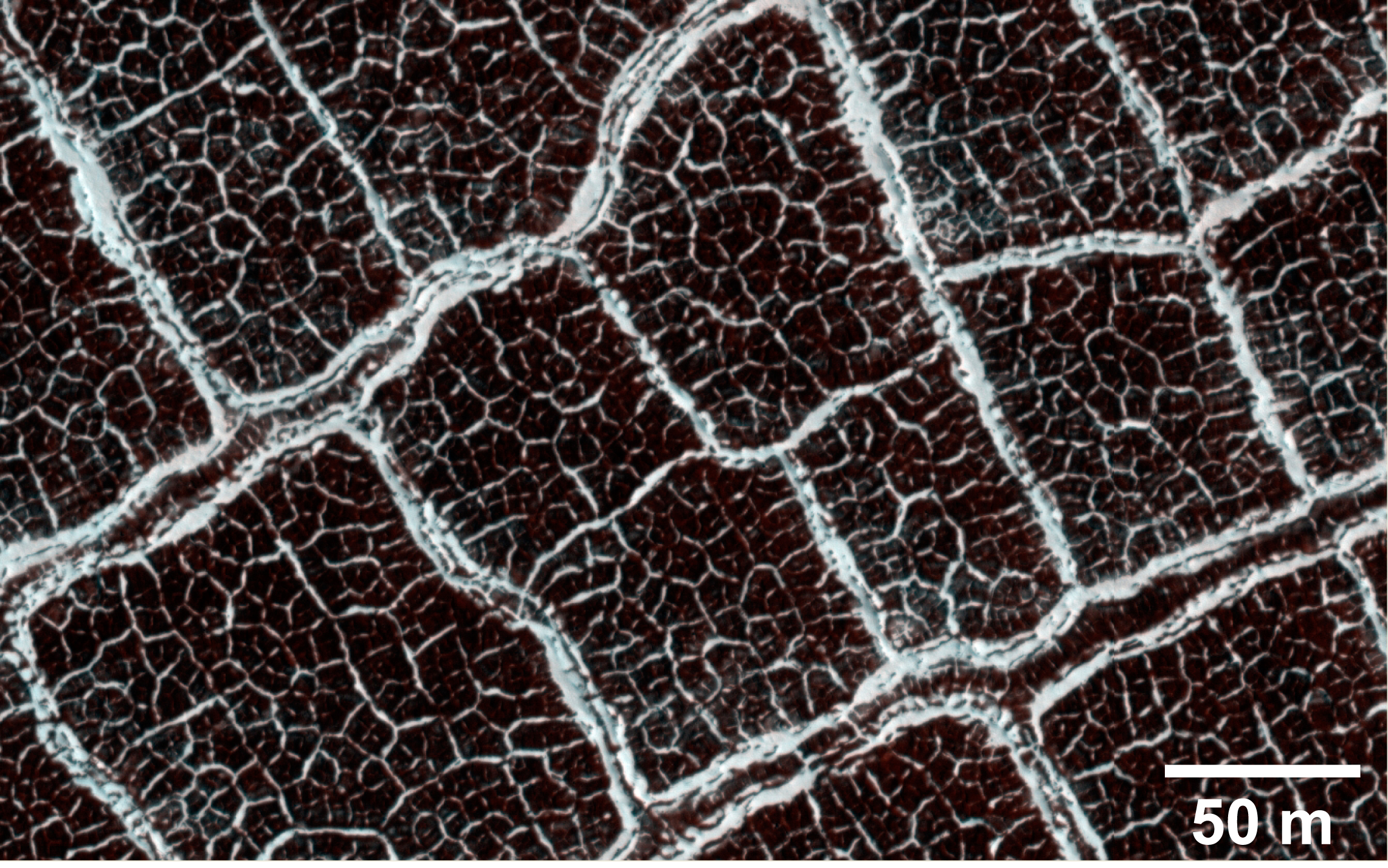
From a distance, the floor of this crater looks like a giant honeycomb or spider web. The intersecting shapes, or polygons, commonly occur in the northern lowlands of Mars.
The polygons in this "patterned ground" are easy to see because their edges are bound by troughs or ridges covered by bright frost relative to their darker, frost-free interiors. Patterned ground on Mars is thought to form as the result of cyclic thermal contraction cracking in the permanently frozen ground.
Scientists study polygonally-patterned ground on Mars because the occurrence and physical characteristics of the polygons helps us understand the recent and past distribution of ice (frozen water) in the shallow subsurface. These features also provide clues about climate conditions. The subimage shows smaller polygons within larger polygons.

This VIS image is part of Tithonium Chasma, part of the western side of Valles Marineris.

This observation covers the Columbia Hills and the surrounding plains of Gusev Crater, which the Mars Exploration Rover Spirit has been exploring since January 2004. Repeat images of this site have been acquired to study aeolian (wind-related) changes on the surface.
This image was acquired in February 2010, six months after the most recent prior image (ESP_014277_1650) and seven months after the most recent color image (ESP_013921_1650) of Spirit's location. During the intervening time, a significant regional dust storm blanketed Gusev crater, and bright Martian dust subsequently settled onto the surface. The surface around the Columbia Hills therefore appears brighter in this new image. However, numerous dark streaks are superposed on this surface; these are probably tracks left by dust devils migrating across the Gusev plains.
While driving around the "Home Plate" feature in the Columbia Hills, Spirit's wheels have excavated bright soils that were previously buried several centimeters beneath the Martian surface. These soils contain minerals such as sulfates and opaline silica that suggest past water activity at this location. The excavated soils are visible from orbit in previous HiRISE color images, where they appear as small, bright, blue-toned patches. These patches are all virtually invisible in the new HiRISE image, suggesting that the soils may have been buried by dust settling during the past few months.
Combining these orbital images with those taken by Spirit on the Martian surface provides a view of aeolian surface changes at a range of scales.

This VIS image of the eastern end of Coprates Chasma contains a landslide deposit and sand dunes. Both features are typical for the chasmata that make up Valles Marineris.

This image shows a new impact crater that formed on Mars between May 2002 and February 2004. It was discovered in data from the Mars Odyssey Mission THEMIS instrument and later confirmed to be an impact crater by the Context Camera on Mars Reconnaissance Orbiter. HiRISE is monitoring this site, at latitude 25.5 degrees and East longitude 221.8 degrees, to watch for changes brought about by the Martian winds.
Comparison of this image with an earlier HiRISE image (PSP_004175_2060) taken more than a Martian year earlier shows significant changes. The dark ejecta from the impact has faded considerably in the interval between June 2007 and February 2010. The fading is probably more significant than represented by these images, since the phase angle (the angle between the Sun, the surface, and the spacecraft) was much larger in the earlier image (72.2 degrees) than in the more recent picture (33.2 degrees). Images taken at higher phase angles tend to emphasize topography and make color and brightness differences less prominent.
The timing of the fading in not known, but the changes could have coincided with a global dust storm that took place in July 2007, shortly after the earlier image was acquired.

A section of Sabis Vallis is shown in today's VIS image.

A portion of this observation shows layered bedrock that has been faulted and tilted.
These layers were likely horizontal when the materials were first deposited, but are now tilted to high angles, approaching 90 degrees, so we get a good cross-sectional view from a bird's-eye view.
The layers have distinctive colors, textures, and thicknesses, so it is easy to correlate layers from place to place. That makes it easy to measure the offset along the many faults breaking the layers.

This VIS image shows some of the effects that wind action has on the surface of Mars. This image is located near Zephyria Planum. Winds in the region have eroded and etched the surface materials.

Common to the northern plains of Mars are rock and boulder strewn landscapes otherwise devoid of major features, short of a few impact craters. This image in the Cydnus Rupes region of northern Utopia Planitia is an excellent example of this sort of terrain.
Boulders up to several meters in size densely coat the landscape. The concentration of these boulders varies at several scales. In some areas only smaller rocks less than a meter across dominate the surface, while a couple hundred meters away may be a somewhat circular "blotch" of larger boulders. Often these blotches of boulders coincide with a faint circular ridge, the remnant of an impact crater now reduced by erosion and infilling to a a mere hint of a crater rim. The abundant boulders excavated by the impact, however, remain scattered over the surface to mark the past event.
Close examination of excavated large rocks and boulders may yield clues to the geologic processes that have shaped the regional landscape over Martian history. However, as a future landing site, these terrains are perilous. Large boulders can damage landing gear and puncture the underside of spacecraft. Rovers would find it extremely difficult to traverse through dense populations of large rocks and boulders.