Saturday, November 29, 2014

False Color Tithonium and Ius Chasmata


This false color image of the region including both Tithonium and Ius Chasmata includes a bluish region in both canyons. This may indicate an atmospheric haze. The potential haze appears to be more widespread in Ius Chasma.

Orbit Number: 56524 Latitude: -5.5587 Longitude: 273.654 Instrument: VIS Captured: 2014-09-10 22:30

Image credit: NASA/JPL-Caltech/Arizona State University

Friday, November 28, 2014

False Color Ascraeus Mons


Today's VIS image is a false color image of part of the northern flank of Ascreaus Mons. The bluish section at the top of the image may indicate an atmospheric haze.

Orbit Number: 56512 Latitude: 13.2761 Longitude: 257.162 Instrument: VIS Captured: 2014-09-09 22:53

Image credit: NASA/JPL-Caltech/Arizona State University

Thursday, November 20, 2014

Pink Cliffs


This small ridge, about 3 feet (1 meter) long, appears to resist wind erosion more than the flatter plates around it. Such differences are among the rock characteristics that NASA's Curiosity Mars rover is examining at selected targets at the base of Mount Sharp.

The ridge pictured here, called "Pink Cliffs," is within the "Pahrump Hills" outcrop forming part of the basal layer of the mountain. This view is a mosaic of exposures acquired by Curiosity's Mast Camera (Mastcam) shortly before a two-week walkabout up the outcrop, scouting to select which targets to examine in greater detail during a second pass.

Pink Cliffs is one of the targets chosen for closer inspection. This image combines several frames taken with the Mastcam on October 7, 2014, the 771st Martian day, or sol of Curiosity's work on Mars. The color has been approximately white-balanced to resemble how the scene would appear under daytime lighting conditions on Earth.

Figure 1 is a version with a scale bar overlaid on the image.

An image showing the Pahrump Hills walkabout route is at PIA19039. An overhead map showing the walkabout drives, from Sol 780 (Oct. 16) to Sol 794 (Oct. 30) is at http://mars.jpl.nasa.gov/msl/images/Curiosity_Location_Sol803-full.jpg.

Image credit: NASA/JPL-Caltech/MSSS

Wednesday, November 19, 2014

Spring in Inca City V


A significant event has occurred in Inca City. The layer of seasonal ice has started to develop long cracks. This is visible in the orange-colored band adjacent to the araneiforms. Fans of dust are emerging from long linear cracks. The cracks form when large plates of ice have no easily ruptured weak spots to release the pressure from gas building up underneath, so the ice simply cracks.

There are also more fans on the ridge at the top of the image, and more have appeared in between the araneiforms. We do not have any analogous processes occurring naturally on Earth: this is truly Martian.

Image credit: NASA/JPL/University of Arizona

Note: For more information, see PIA18896: Spring in Inca City V.

Tuesday, November 18, 2014

Spring in Inca City IV


At certain times in spring, fans take on a gray or blue appearance. This is the time in Inca City when this phenomenon happens.

On the ridge at the top of the image fans have lengthened and now look more gray than the blotches on the araneiforms. At the bottom of the image they are distinctly blue in color.

Two theories have been suggested: perhaps fine particles sink into the seasonal layer of ice so they no longer appear dark. Or, maybe the gas that is released from under the ice condenses and falls to the surface as a bright fresh layer of frost. It is quite likely that both of these theories are correct.

Image credit: NASA/JPL/University of Arizona

Note: For more information, see PIA18895: Spring in Inca City IV.

Monday, November 17, 2014

Spring in Inca City III


In Inca City another week has passed, and there are a few more fans on the ridge. We are studying the sequence of spring activity with the help of citizen scientists at the Planetfour website, sponsored by Zooniverse.

Citizens of planet Earth log on and identify and measure fans and blotches in the South polar region of Mars imaged by HiRISE. With their help we can study the polar weather by looking at how the fan directions change through the spring.

We see how the number of fans and blotches depends on the thickness of the ice layer and how high the sun is in the sky. If you would like to be a part of this endeavor join us at www.planetfour.org.

Image credit: NASA/JPL/University of Arizona

Note: For more information, see PIA18894: Spring in Inca City III.

Sunday, November 16, 2014

Spring in Inca City II


It is about two weeks later in Inca City and the season is officially spring. Numerous changes have occurred. Large blotches of dust cover the araneiforms. Dark spots on the ridge show places where the seasonal polar ice cap has ruptured, releasing gas and fine material from the surface below.

At the bottom of the image fans point in more than one direction from a single source, showing that the wind has changed direction while gas and dust were flowing out. Was the flow continuous or has the vent opened and closed?

Image credit: NASA/JPL/University of Arizona

Note: For more information, see PIA18893: Spring in Inca City II.

Saturday, November 15, 2014

Spring in Inca City I


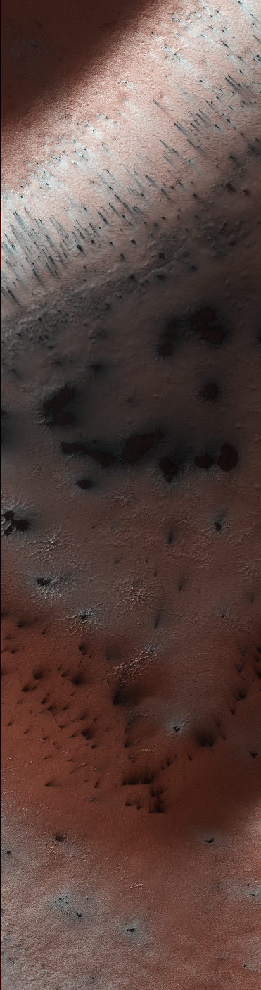
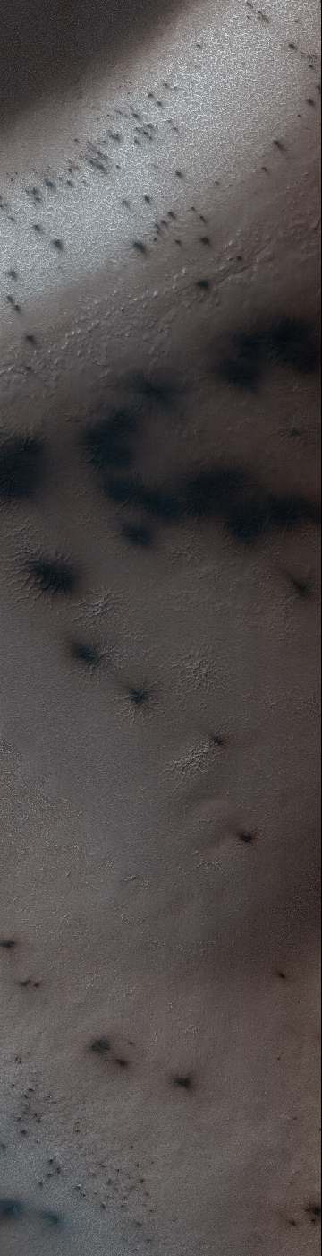
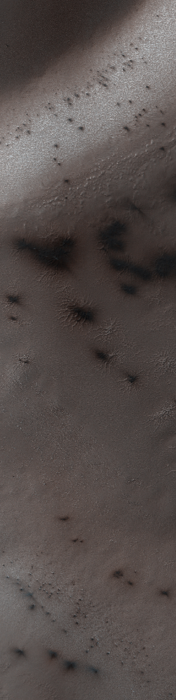
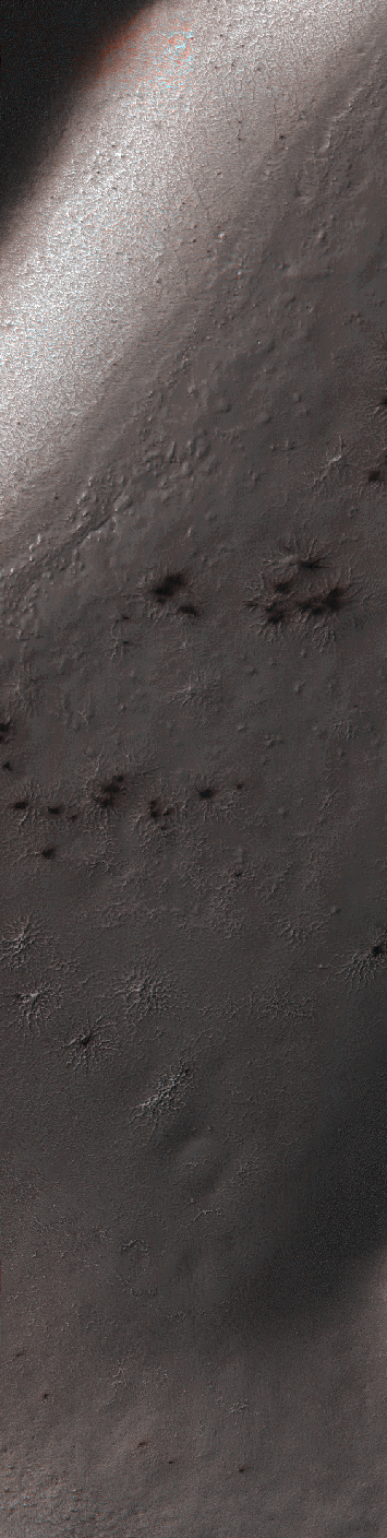
Every winter a layer of carbon dioxide ice — or, dry ice — condenses in the Southern polar region, forming a seasonal polar cap less than 1 meter deep. Early in the spring the ice layer begins to sublimate (going directly from a solid to gas) from the top and bottom of the ice layer. Under the ice gas pressure builds up until a weak spot in the ice layer ruptures. The gas rushes out and as it escapes it erodes a bit of the surface.

Fine particles are carried by the gas to the top of the ice and then fall out in fan-shaped deposits. The direction of the fan shows the direction either of the wind or down the slope. If the wind is not blowing a dark blotch settles around the spot the gas escaped.

This region is known informally as Inca City, and it has a series of distinctive ridges. On the floor between the ridges are radially organized channels, known colloquially as spiders, more formally called "araneiforms." The channels have been carved in the surface over many years by the escaping pressurized gas. Every spring they widen just a bit.

This was the first image to be acquired after the sun rose on Inca City, marking the end to polar night. A few fans are visible emerging from the araneiforms.

Image credit: NASA/JPL/University of Arizona

Note: For more information, see PIA18892: Spring in Inca City I.

Sunday, November 2, 2014

Partially-Filled Impact Crater in Elysium Planitia


This image shows an impact crater that was cut by lava in the Elysium Planitia region of Mars. The relatively flat, shallow floor, rough surface texture, and possible cooling cracks seem to indicate that the crater was partially filled with lava. The northern part of the image also shows a more extensive lava flow deposit that surrounds the impact ejecta of the largest impact crater in the image.

Which way did the lava flow? It might appear that the lava flowed from the north through the channel into the partially filled crater. However, if you look at the anaglyph with your red and blue 3D glasses, it becomes clear that the partially filled crater sits on top of the large crater's ejecta blanket, making it higher than the lava flow to the north. Since lava does not flow uphill, that means the explanation isn't so simple.

We have seen much evidence for lava flows in this region that flowed to much higher levels than the present surface, then deflated or drained away. That may have happened here: lava flowed from from north to south to fill this crater, but then it drained back to the north, carving this channel.

The topographic information that we gained from having a stereo pair let us answer a question that we could not have with only a single image. This is a great example of why we take stereo images, where the two images are used to make a 3D image.

Image credit: NASA/JPL/University of Arizona

Note: For more information, see PIA18887: Which Way is Up?

Saturday, November 1, 2014

Hardened Dunes in Arcadia Planitia


HiRISE, with its high resolution and 8 years in orbit about Mars, has shown that many dunes and ripples on the planet are active. This demonstrates that in some areas sand is loose enough and winds strong enough, that significant change can occur.

Nevertheless, other Martian dunes are clearly *inactive*. This image in Arcadia Planitia shows dunes in a crater. Unlike active dunes on the planet, those here are bright, and, zooming in, there are several lines of evidence indicating that the dunes have become indurated, that is, hardened into cohesive sediment or even into sandstone rock. For example, the dune field at the southern edge is cut off by a step cliff, indicating erosion of hard material. Although fine scale ripples on the original dune surface are preserved, we also see large scale fluting from southwest to northeast, a common texture associated with wind-induced sand abrasion.

How these dunes became indurated is unknown. One possibility is that this area of Mars was buried and then exhumed, a process that seems to have occurred many times in the Martian past over various areas of the planet. During burial, compaction and possibly ground water circulation would have indurated the dunes, leaving them as a hard sandstone that, when exhumed, was subsequently partially eroded.

Note: a version of the cutout is with only the scale bar is here.

Image credit: NASA/JPL/University of Arizona

Note: For more information, see PIA18890: Hardened Dunes in Arcadia Planitia.