Tuesday, April 30, 2013

Gale Crater (2010) #19


During the month of April Mars will be in conjunction relative to the Earth. This means the Sun is in the line-of-sight between Earth and Mars, and communication between the two planets is almost impossible. For conjunction, the rovers and orbiting spacecraft at Mars continue to operate, but do not send the data to Earth. This recorded data will be sent to Earth when Mars moves away from the sun and the line-of-sight between Earth and Mars is reestablished. During conjunction the THEMIS image of the day will be a visual tour of Gale Crater, the location of the newest rover Curiosity.

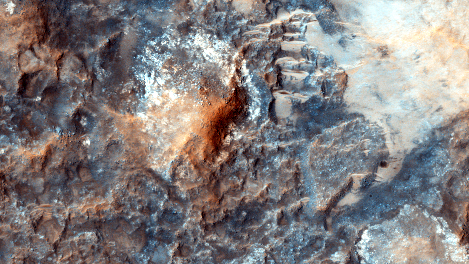
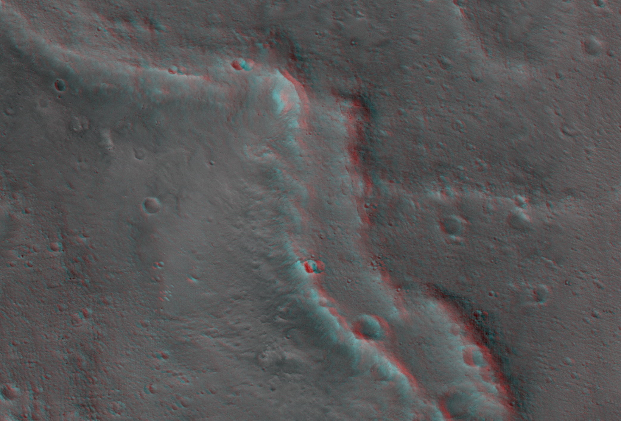
This image shows the western margin of Mt. Sharp. The large channel from past images enters the frame in the center and then veers to the northwest. A large region of sand and sand dunes covers the crater floor.

Orbit Number: 39120 Latitude: -5.05204 Longitude: 137.134 Instrument: VIS Captured: 2010-10-09 09:52

Photo credit: NASA/JPL-Caltech/Arizona State University

Note: This is the nineteenth in a series of images in which the THEMIS team is currently showing the central region of Gale Crater, starting at the eastern rim and moving past Mount Sharp to the western rim. Starting with image #9, the images are being shown from east to west. All of the images in this series I will name "Gale Crater (XXXX) #Y", in which XXXX is the year in which the photo was actually taken, and Y is the sequence number (1 through...).

Saturday, April 27, 2013

Gale Crater (2009) #18


During the month of April Mars will be in conjunction relative to the Earth. This means the Sun is in the line-of-sight between Earth and Mars, and communication between the two planets is almost impossible. For conjunction, the rovers and orbiting spacecraft at Mars continue to operate, but do not send the data to Earth. This recorded data will be sent to Earth when Mars moves away from the sun and the line-of-sight between Earth and Mars is reestablished. During conjunction the THEMIS image of the day will be a visual tour of Gale Crater, the location of the newest rover Curiosity.

Today's image shows almost the same region as the previous image - showing the major channel that started near the top of Mt. Sharp. Near the top of this image is a wide valley that reaches to the crater floor and the nearby dunes. It is this valley that has been chosen as a possible route for Curiosity to use for driving onto Mt. Sharp.

Orbit Number: 35551 Latitude: -5.16407 Longitude: 137.394 Instrument: VIS Captured: 2009-12-19 13:02

Photo credit: NASA/JPL-Caltech/Arizona State University

Note: This is the eighteenth in a series of images in which the THEMIS team is currently showing the central region of Gale Crater, starting at the eastern rim and moving past Mount Sharp to the western rim. Starting with image #9, the images are being shown from east to west. All of the images in this series I will name "Gale Crater (XXXX) #Y", in which XXXX is the year in which the photo was actually taken, and Y is the sequence number (1 through...).

Ancient Rocks of the Isidis Basin and Libya Montes Exposed and Preserved by Hashir Crater


The focus of this HiRISE observation is the inner portion of the approximately 9-kilometer diameter Hashir Crater.

Hashir is located at 84.56 degrees east, 3.63 degrees north within the transition from the vast Isidis Basin plains (Isidis Planitia) to the great circumferential mountains of Libya Montes (i.e., the ancient and dissected mountains raised-up from the Isidis-forming event).

Hashir is of particular interest to scientists because there are several spectral units that are characteristic of the Isidis Basin/Libya Montes region that are exposed or preserved within it. Hashir and its surroundings have been spectrally characterized by multiple orbiting spectrometers spanning almost 25 years, including: Phobos 2-ISM, MGS-TES, MO-THEMIS, MEx-OMEGA and most recently by MRO-CRISM. The results from the analysis of these data indicate the presence of surface materials rich in olivine, pyroxene, clays (Fe/Mg-smectites) and carbonate. The latter two are of particular interest as they were likely formed by alteration of the ancient basaltic rocks through interactions with water. The Fe/Mg-phyllosilicates and carbonate are often associated with olivine in CRISM and HiRISE images because these alteration minerals are observed where the olivine-rich lavas have been eroded away.

This 3D perspective image of Hashir Crater was generated by combining color from CRISM with the high-resolution of a gray-scale HiRISE RED image draped over a HiRISE stereo derived digital terrain model (DTM) with a 3x vertical enhancement. This close-up view from the south (looking north) illustrates the occurrence of the pyroxene-bearing caprock in blue on top of olivine-bearing layered bedrock in green, which in turn overlies a Fe/Mg-smectite-bearing unit in red. The hilly red unit is interpreted to be the central uplift of Hashir Crater, which are rocks uplifted and exposed by the crater-forming event. The blue and green units are more recent lava flows or impact melt deposits from Isidis that filled in Hashir after it formed and have been since eroded back by the high winds in the Libya Montes region.

Image credit: NASA/JPL/University of Arizona/USGS

Friday, April 26, 2013

Gale Crater (2002) #17


During the month of April Mars will be in conjunction relative to the Earth. This means the Sun is in the line-of-sight between Earth and Mars, and communication between the two planets is almost impossible. For conjunction, the rovers and orbiting spacecraft at Mars continue to operate, but do not send the data to Earth. This recorded data will be sent to Earth when Mars moves away from the sun and the line-of-sight between Earth and Mars is reestablished. During conjunction the THEMIS image of the day will be a visual tour of Gale Crater, the location of the newest rover Curiosity.

Today's image continues to follow the channel seen in the past two images. The rover landing site is at the top margin of this image.

Orbit Number: 1494 Latitude: -5.03202 Longitude: 137.326 Instrument: VIS Captured: 2002-04-16 12:47

Photo credit: NASA/JPL-Caltech/Arizona State University

Note: This is the seventeenth in a series of images in which the THEMIS team is currently showing the central region of Gale Crater, starting at the eastern rim and moving past Mount Sharp to the western rim. Starting with image #9, the images are being shown from east to west. All of the images in this series I will name "Gale Crater (XXXX) #Y", in which XXXX is the year in which the photo was actually taken, and Y is the sequence number (1 through...).

Thursday, April 25, 2013

Gale Crater (2009) #16


During the month of April Mars will be in conjunction relative to the Earth. This means the Sun is in the line-of-sight between Earth and Mars, and communication between the two planets is almost impossible. For conjunction, the rovers and orbiting spacecraft at Mars continue to operate, but do not send the data to Earth. This recorded data will be sent to Earth when Mars moves away from the sun and the line-of-sight between Earth and Mars is reestablished. During conjunction the THEMIS image of the day will be a visual tour of Gale Crater, the location of the newest rover Curiosity.

Today's image shows the westward continuation of the channel from yesterday's image. Note how the channel widens as it moves downslope (to the west).

Orbit Number: 33392 Latitude: -5.14777 Longitude: 137.373 Instrument: VIS Captured: 2009-06-24 18:48

Photo credit: NASA/JPL-Caltech/Arizona State University

Note: This is the sixteenth in a series of images in which the THEMIS team is currently showing the central region of Gale Crater, starting at the eastern rim and moving past Mount Sharp to the western rim. Starting with image #9, the images are being shown from east to west. All of the images in this series I will name "Gale Crater (XXXX) #Y", in which XXXX is the year in which the photo was actually taken, and Y is the sequence number (1 through...).

Wednesday, April 24, 2013

Gale Crater (2009) #15


During the month of April Mars will be in conjunction relative to the Earth. This means the Sun is in the line-of-sight between Earth and Mars, and communication between the two planets is almost impossible. For conjunction, the rovers and orbiting spacecraft at Mars continue to operate, but do not send the data to Earth. This recorded data will be sent to Earth when Mars moves away from the sun and the line-of-sight between Earth and Mars is reestablished. During conjunctionthe THEMIS image of the day will be a visual tour of Gale Crater, the location of the newest rover Curiosity.

The highest elevations of Mt. Sharp are just outside this image (to the east). In the center of this image is a channel. This channel indicates that fluids have played a part in eroding Mt. Sharp. Other erosion features indicate that wind probably also has played a part in eroding the deposit.

Orbit Number: 35214 Latitude: -5.15393 Longitude: 137.472 Instrument: VIS Captured: 2009-11-21 19:07

Photo credit: NASA/JPL-Caltech/Arizona State University

Note: This is the fifteenth in a series of images in which the THEMIS team is currently showing the central region of Gale Crater, starting at the eastern rim and moving past Mount Sharp to the western rim. Starting with image #9, the images are being shown from east to west. All of the images in this series I will name "Gale Crater (XXXX) #Y", in which XXXX is the year in which the photo was actually taken, and Y is the sequence number (1 through...).

Gale Crater Anaglyph


Left and right eyes of the Navigation Camera (Navcam) in NASA's Curiosity Mars rover took the dozens of images combined into this stereo scene of the rover and its surroundings. The component images were taken during the 166th, 168th and 169th Martian days, or sols, of Curiosity's work on Mars (January 23, 25 and 26, 2013). The scene appears three dimensional when viewed through red-blue glasses with the red lens on the left. It spans 360 degrees, with Mount Sharp on the southern horizon.

In the center foreground, the rover's arm holds the tool turret above a target called "Wernecke" on the "John Klein" patch of pale-veined mudstone. On Sol 169, Curiosity used its dust-removing brush and Mars Hand Lens Imager (MAHLI) on Wernecke (see PIA16790). About two weeks later, Curiosity used its drill at a point about 1 foot (30 centimeters) to the right of Wernecke to collect the first drilled sample from the interior of a rock on Mars. Seams have been eliminated from the sky portion of the mosaic to better simulate the vista a person standing on Mars would see. The mosaic has been cropped to reduce areas of extreme disparities between the views from the left and right eyes, which make viewing the 3-D anaglyph difficult. Another version of this anaglyph made from the images as captured by Curiosity is available at PIA16847.

Image credit: NASA/JPL-Caltech

Tuesday, April 23, 2013

Gale Crater (2002) #14


During the month of April Mars will be in conjunction relative to the Earth. This means the Sun is in the line-of-sight between Earth and Mars, and communication between the two planets is almost impossible. For conjunction, the rovers and orbiting spacecraft at Mars continue to operate, but do not send the data to Earth. This recorded data will be sent to Earth when Mars moves away from the sun and the line-of-sight between Earth and Mars is reestablished. During conjunction the THEMIS image of the day will be a visual tour of Gale Crater, the location of the newest rover Curiosity.

We've moved slightly westward of yesterday's image and see one of the unusual features of Mt. Sharp. The highest elevation of the layered deposit occurs at the top of this image, but just south of the center of the image is a peak that does not appear to be layered and is eroding in a different manner than the rest of Mt. Sharp. This location and appearance of this rugged peak point to it being the remnant of a central peak formed at the time Gale Crater was created.

Orbit Number: 1132 Latitude: -5.29355 Longitude: 137.84 Instrument: VIS Captured: 2002-03-17 17:34

Photo credit: NASA/JPL-Caltech/Arizona State University

Note: This is the fourteenth in a series of images in which the THEMIS team is currently showing the central region of Gale Crater, starting at the eastern rim and moving past Mount Sharp to the western rim. Starting with image #9, the images are being shown from east to west. All of the images in this series I will name "Gale Crater (XXXX) #Y", in which XXXX is the year in which the photo was actually taken, and Y is the sequence number (1 through...).

Saturday, April 20, 2013

Gale Crater (2002) #13


During the month of April Mars will be in conjunction relative to the Earth. This means the Sun is in the line-of-sight between Earth and Mars, and communication between the two planets is almost impossible. For conjunction, the rovers and orbiting spacecraft at Mars continue to operate, but do not send the data to Earth. This recorded data will be sent to Earth when Mars moves away from the sun and the line-of-sight between Earth and Mars is reestablished. During conjunction the THEMIS image of the day will be a visual tour of Gale Crater, the location of the newest rover Curiosity.

Today's image show the region slightly south of yesterday's image, including the floor of the crater at the bottom of the frame.

Orbit Number: 1831 Latitude: -5.18179 Longitude: 138.048 Instrument: VIS Captured: 2002-05-14 06:36

Photo credit: NASA/JPL-Caltech/Arizona State University

Note: This is the thirteenth in a series of images in which the THEMIS team is currently showing the central region of Gale Crater, starting at the eastern rim and moving past Mount Sharp to the western rim. Starting with image #9, the images are being shown from east to west. All of the images in this series I will name "Gale Crater (XXXX) #Y", in which XXXX is the year in which the photo was actually taken, and Y is the sequence number (1 through...).

Friday, April 19, 2013

Gale Crater (2009) #12


During the month of April Mars will be in conjunction relative to the Earth. This means the Sun is in the line-of-sight between Earth and Mars, and communication between the two planets is almost impossible. For conjunction, the rovers and orbiting spacecraft at Mars continue to operate, but do not send the data to Earth. This recorded data will be sent to Earth when Mars moves away from the sun and the line-of-sight between Earth and Mars is reestablished. During conjunction the THEMIS image of the day will be a visual tour of Gale Crater, the location of the newest rover Curiosity.

Continuing westward, this image shows Mt. Sharp just east of the highest peak of the deposit. The dark material near the top of the image is likely sand. This image shows the dark material on the floor as well as on Mt. Sharp.

Orbit Number: 34540 Latitude: -4.85635 Longitude: 138.099 Instrument: VIS Captured: 2009-09-27 07:24

Photo credit: NASA/JPL-Caltech/Arizona State University

Note: This is the twelfth in a series of images in which the THEMIS team is currently showing the central region of Gale Crater, starting at the eastern rim and moving past Mount Sharp to the western rim. Starting with image #9, the images are being shown from east to west. All of the images in this series I will name "Gale Crater (XXXX) #Y", in which XXXX is the year in which the photo was actually taken, and Y is the sequence number (1 through...).

Thursday, April 18, 2013

Gale Crater (2003) #11


During the month of April Mars will be in conjunction relative to the Earth. This means the Sun is in the line-of-sight between Earth and Mars, and communication between the two planets is almost impossible. For conjunction, the rovers and orbiting spacecraft at Mars continue to operate, but do not send the data to Earth. This recorded data will be sent to Earth when Mars moves away from the sun and the line-of-sight between Earth and Mars is reestablished. During conjunction the THEMIS image of the day will be a visual tour of Gale Crater, the location of the newest rover Curiosity. Today's Gale image shows the region just slightly south of yesterday's image. The dark region on the crater floor is sand. The dunes that encircle Mt. Sharp are most likely comprised of sand eroded from Mt. Sharp itself.

Orbit Number: 7411 Latitude: -5.49018 Longitude: 138.303 Instrument: VIS Captured: 2003-08-16 14:21

Photo credit: NASA/JPL-Caltech/Arizona State University

Note: This is the eleventh in a series of images in which the THEMIS team is currently showing the central region of Gale Crater, starting at the eastern rim and moving past Mount Sharp to the western rim. Starting with image #9, the images are being shown from east to west. All of the images in this series I will name "Gale Crater (XXXX) #Y", in which XXXX is the year in which the photo was actually taken, and Y is the sequence number (1 through...).

Endeavour Crater


This stereo view from the navigation camera on NASA's Mars Exploration Rover Opportunity shows a vista across Endeavour Crater, with the rover's own shadow in the foreground. The view spans 216 compass degrees, from north at the left to south-southwest on the right. It appears three-dimensional when seen through blue-red glasses with the red lens on the left.

Opportunity has been studying the western rim of Endeavour Crater since arriving there in August 2011. The crater spans 14 miles (22 kilometers) in diameter, by far the largest that Opportunity has visited since it landed on Mars in January 2004.

The component images in this mosaic view were taken during the 3,020th Martian day, or sol, of Opportunity's work on Mars (July 22, 2012). Figure 1 and Figure 2 are the separate left-eye and right-eye mosaics that are combined into the stereo view.

Image Credit: NASA/JPL-Caltech

Wednesday, April 17, 2013

Gale Crater (2011) #10


During the month of April Mars will be in conjunction relative to the Earth. This means the Sun is in the line-of-sight between Earth and Mars, and communication between the two planets is almost impossible. For conjunction, the rovers and orbiting spacecraft at Mars continue to operate, but do not send the data to Earth. This recorded data will be sent to Earth when Mars moves away from the sun and the line-of-sight between Earth and Mars is reestablished. During conjunction the THEMIS image of the day will be a visual tour of Gale Crater, the location of the newest rover Curiosity. This image shows more of the weathering of the eastern side of Mt. Sharp.

Orbit Number: 42664 Latitude: -5.33698 Longitude: 138.32 Instrument: VIS Captured: 2011-07-28 05:08

Photo credit: NASA/JPL-Caltech/Arizona State University

Note: This is the tenth in a series of images in which the THEMIS team is currently showing the central region of Gale Crater, starting at the eastern rim and moving past Mount Sharp to the western rim. Starting with image #9, the images are being shown from east to west. All of the images in this series I will name "Gale Crater (XXXX) #Y", in which XXXX is the year in which the photo was actually taken, and Y is the sequence number (1 through...).

Opportunity's Shadow and Endeavour Crater


NASA's Mars Exploration Rover Opportunity used its navigation camera to record this vista looking eastward across Endeavour Crater, with the rover's own shadow in the foreground.

Opportunity has been studying the western rim of Endeavour Crater since arriving there in August 2011. The crater spans 14 miles (22 kilometers) in diameter, by far the largest that Opportunity has visited since it landed on Mars in January 2004.

The component images in this mosaic view were taken during the 3,020th Martian day, or sol, of Opportunity's work on Mars (July 22, 2012).

Photo credit: NASA/JPL-Caltech

Tuesday, April 16, 2013

Gale Crater (2009) #9


During the month of April Mars will be in conjunction relative to the Earth. This means the Sun is in the line-of-sight between Earth and Mars, and communication between the two planets is almost impossible. For conjunction, the rovers and orbiting spacecraft at Mars continue to operate, but do not send the data to Earth. This recorded data will be sent to Earth when Mars moves away from the sun and the line-of-sight between Earth and Mars is reestablished. During conjunction the THEMIS image of the day will be a visual tour of Gale Crater, the location of the newest rover Curiosity. We now begin a traverse across Mt. Sharp moving from east to west. The layering of the material that comprises Mt. Sharp is visible in the bottom third of this image. This image also shows the weathering that has affected Mt. Sharp.

Orbit Number: 33941 Latitude: -5.32425 Longitude: 138.404 Instrument: VIS Captured: 2009-08-08 23:45

Photo credit: NASA/JPL-Caltech/Arizona State University

Note: This is the ninth in a series of images in which the THEMIS team is currently showing the central region of Gale Crater, starting at the eastern rim and moving past Mount Sharp to the western rim. Starting with image #9, The images are being shown from east to west. All of the images in this series I will name "Gale Crater (XXXX) #Y", in which XXXX is the year in which the photo was actually taken, and Y is the sequence number (1 through...).

Ridges and Grooves in Mamers Valles


Long linear ridges and grooves curve, wave, and buckle across most of this image. Here, as elsewhere on Mars, these linear ridges and grooves fill a valley floor, hence their name, "lineated valley fill."

Because these features are only found in valleys in the middle latitudes (30 to 60 degrees) of the Northern and Southern hemispheres, scientists had long suspected that they were associated with some ancient climate that had prevailed in that latitudinal band. Based on peering beneath the surface using radar, scientists now think that lineated valley fill is probably merely a rocky veneer atop a glacier of nearly pure ice! The rocks that make up the linear ridges and grooves were oriented by the ancient flow of the glacier underneath.

Photo credit: NASA/JPL/University of Arizona

Note: This photograph is located in the Mamers Valles region of northern Arabia Terra.

Monday, April 15, 2013

Megabreccia in a Terra Cimmeria Impact Crater


"Megabreccia" is a term we use to describe jumbled, fragmented blocks of rock larger than 1 meter across, in a matrix of finer-grained materials. It's the result of energetic processes, typically from an impact event.

This image was acquired by HiRISE only in the narrow color strip, as a ride-along with a CRISM target, since HiRISE had previously imaged this location.

Photo credit: NASA/JPL/University of Arizona

Note: This image is located in northern Terra Cimmeria, near the "shore" of Elysium Planitia. The closest named feature is Al-Qahira Vallis, to the northwest.

Sunday, April 14, 2013

Bright Tracks from Bouncing and Rolling Boulders


This image shows a well-preserved impact crater. A closeup view highlights distinctive bright lines and spots on the steep slope on the north side.

HiRISE imaged this crater 5 years ago (2.6 Mars years ago), in March 2008, and no such pattern was visible. The discontinuous bright spots indicate bouncing, so we interpret these features as due to boulders bouncing and rolling down the slope.

Where did the boulders come from? Maybe they fell off of the steep upper cliffs of the crater, although we don't see any new bright features there that point to the source. Maybe the rocks were ejecta from a new impact event somewhere nearby.

Why are the trails bright? Perhaps the shallow subsurface soil here is generally brighter than the surface soil, as revealed by the Spirit rover in a part of Gusev Crater. It can't be bright from ice because this is a warm equator-facing slope seen in the summer.

Photo credit: NASA/JPL/University of Arizona

Note: This image is located in Terra Cimmeria, about halfway between Ariadnes Colles to the north and Bjerknes Crater to the south.

Saturday, April 13, 2013

Gale Crater (2008) #8


During the month of April Mars will be in conjunction relative to the Earth. This means the Sun is in the line-of-sight between Earth and Mars, and communication between the two planets is almost impossible. For conjunction, the rovers and orbiting spacecraft at Mars continue to operate, but do not send the data to Earth. This recorded data will be sent to Earth when Mars moves away from the sun and the line-of-sight between Earth and Mars is reestablished. During conjunction the THEMIS image of the day will be a visual tour of Gale Crater, the location of the newest rover Curiosity. This image shows the rough terrain just inside the eastern rim of Gale Crater as well as the eastern extent of Mr. Sharp.

Orbit Number: 27179 Latitude: -5.29255 Longitude: 138.708 Instrument: VIS Captured: 2008-01-30 03:48

Photo credit: NASA/JPL-Caltech/Arizona State University

Note: This is the eighth in a series of images in which the THEMIS team is currently showing the northern ring of Gale Crater, between the impact crater's rim to the north and Mount Sharp to the south. The images are being shown from west to east. All of the images in this series I will name "Gale Crater (XXXX) #Y", in which XXXX is the year in which the photo was actually taken, and Y is the sequence number (1 through...).

Mars-3 Lander Hardware Found?


This set of images shows what might be hardware from the Soviet Union's 1971 Mars 3 lander, seen in a pair of images from the High Resolution Imaging Science Experiment (HiRISE) camera on NASA's Mars Reconnaissance Orbiter.

The possible Mars 3 lander hardware was found by an Internet group of Russian citizen enthusiasts who follow news about Mars and NASA's Curiosity rover.

In 1971, the former Soviet Union launched the Mars 2 and Mars 3 missions to Mars. Each consisted of an orbiter plus a lander. Both orbiter missions succeeded, although the surface of Mars was obscured by a planet-encircling dust storm. The Mars 2 lander crashed. Mars 3 became the first successful soft landing on the Red Planet, but stopped transmitting after just 14.5 seconds for unknown reasons.

The predicted landing site was at latitude 45 degrees south, longitude 202 degrees east, in Ptolemaeus Crater. HiRISE acquired a large image at this location in November 2007. This image (HiRISE catalog PSP_006154_1345) contains 1.8 billion pixels of data, so about 2,500 typical computer screens would be needed to view the entire image at full resolution. Promising candidates for the hardware from Mars 3 were found on December 31, 2012.

Vitali Egorov from St. Petersburg, Russia, heads the largest Russian Internet community about Curiosity, at http://vk.com/curiosity_live. His subscribers did the preliminary search for Mars 3 via crowd-sourcing. Egorov modeled what Mars 3 hardware pieces should look like in a HiRISE image, and the group carefully searched the many small features in this large image, finding what appear to be viable candidates in the southern part of the scene. Each candidate has a size and shape consistent with the expected hardware, and they are arranged on the surface as expected from the entry, descent and landing sequence.

An advisor to the group, Alexander Basilevsky, of Vernadsky Institute of Geochemistry and Analytical Chemistry, Moscow, contacted Alfred McEwen, principal investigator for HiRISE, suggesting a follow-up image. HiRISE acquired this image (ESP_031036_1345) on March 10, 2013. The image was targeted to cover some of the hardware candidates in color and to get a second look with different illumination angles. Meanwhile, Basilevsky and Egorov contacted Russian engineers and scientists who worked on Mars 3 for more information.

The candidate parachute is the most distinctive and unusual feature in the images. It is an especially bright spot for this region, about 8.2 yards (7.5 meters) in diameter. The parachute would have a diameter of 12 yards (11 meters) if fully spread out over the surface, so this is consistent. In the second HiRISE image the parachute appears to have brightened over much of its surface. The brightening is probably due to better illumination over the sloping surface, but it is also possible that dust was removed during the intervening years, resulting in brightening of the parachute. HiRISE recently showed that the parachute of the Mars Science Laboratory mission has shifted in the wind (see PIA16813), which might also kick off dust.

The descent module or retrorocket was attached to the lander container by a chain, and the candidate feature has the right size and even shows a linear extension that could be a chain. Nearby the candidate descent module is a feature with the right size and shape to be the actual lander, with four open petals. The image of the candidate heat shield matches a shield-shaped object with the right size if partly buried.

Together, this set of features and their layout on the ground provide a remarkable match to what is expected from the Mars 3 landing, but alternative explanations for the features cannot be ruled out. Further analysis of the data and future images to better understand the 3-dimensional shapes may help to confirm this interpretation.

Image credit: NASA/JPL-Caltech/University of Arizona

Note: For more information, see Could This Be the Soviet Mars 3 Lander? and NASA Mars Orbiter Images May Show 1971 Soviet Lander.

Friday, April 12, 2013

Gale Crater (2009) #7


During the month of April Mars will be in conjunction relative to the Earth. This means the Sun is in the line-of-sight between Earth and Mars, and communication between the two planets is almost impossible. For conjunction, the rovers and orbiting spacecraft at Mars continue to operate, but do not send the data to Earth. This recorded data will be sent to Earth when Mars moves away from the sun and the line-of-sight between Earth and Mars is reestablished. During conjunction the THEMIS image of the day will be a visual tour of Gale Crater, the location of the newest rover Curiosity. Moving further east, we see more dunes. This image shows more of the crater rim and the crater floor seen in the image is not as smooth as in other parts of the crater.

Orbit Number: 35526 Latitude: -4.59829 Longitude: 138.663 Instrument: VIS Captured: 2009-12-17 11:38

Photo credit:  NASA/JPL-Caltech/Arizona State University


Note: This is the seventh in a series of images in which the THEMIS team is currently showing the northern ring of Gale Crater, between the impact crater's rim to the north and Mount Sharp to the south. The images are being shown from west to east. All of the images in this series I will name "Gale Crater (XXXX) #Y", in which XXXX is the year in which the photo was actually taken, and Y is the sequence number (1 through...).

Raindrop Dunes in Copernicus Crater


The dark features here look like raindrops, but are actually sand dunes. This spot was targeted by CRISM because the dunes are rich in the mineral olivine.

Olivine-rich dunes are very rare on Earth, as olivine rapidly weathers to clays in a wet environment. There is also olivine-rich bedrock in the central peaks of Copernicus Crater on the Moon.

There is only a handful of very important scientists, like Nicolaus Copernicus (1473-1543) who have craters named after them on both Mars and the Moon.

Photo credit: NASA/JPL/University of Arizona

Thursday, April 11, 2013

Gale Crater (2006) #6


During the month of April Mars will be in conjunction relative to the Earth. This means the Sun is in the line-of-sight between Earth and Mars, and communication between the two planets is almost impossible. For conjunction, the rovers and orbiting spacecraft at Mars continue to operate, but do not send the data to Earth. This recorded data will be sent to Earth when Mars moves away from the sun and the line-of-sight between Earth and Mars is reestablished. During conjunction the THEMIS image of the day will be a visual tour of Gale Crater, the location of the newest rover Curiosity. Continuing eastward, this image of Gale shows the reappearance of dunes on the crater floor near the margin of Mt. Sharp.

Orbit Number: 18668 Latitude: -4.59664 Longitude: 138.381 Instrument: VIS Captured: 2006-02-28 09:38

Photo credit: NASA/JPL-Caltech/Arizona State University

Note: This is the sixth in a series of images in which the THEMIS team is currently showing the northern ring of Gale Crater, between the impact crater's rim to the north and Mount Sharp to the south. The images are being shown from west to east. All of the images in this series I will name "Gale Crater (XXXX) #Y", in which XXXX is the year in which the photo was actually taken, and Y is the sequence number (1 through...).

Wednesday, April 10, 2013

Gale Crater (2010) #5


During the month of April Mars will be in conjunction relative to the Earth. This means the Sun is in the line-of-sight between Earth and Mars, and communication between the two planets is almost impossible. For conjunction, the rovers and orbiting spacecraft at Mars continue to operate, but do not send the data to Earth. This recorded data will be sent to Earth when Mars moves away from the sun and the line-of-sight between Earth and Mars is reestablished. During conjunction the THEMIS image of the day will be a visual tour of Gale Crater, the location of the newest rover Curiosity. Moving eastward from the previous image, we continue to see the northern floor and rim of Gale Crater and the northern part of Mt. Sharp. This image shows a weathered region of the lower elevations of Mt. Sharp.

Orbit Number: 37061 Latitude: -4.39789 Longitude: 138.015 Instrument: VIS Captured: 2010-04-22 20:55

Photo credit: NASA/JPL-Caltech/Arizona State University

Note: This is the fifth in a series of images in which the THEMIS team is currently showing the northern ring of Gale Crater, between the impact crater's rim to the north and Mount Sharp to the south. The images are being shown from west to east. All of the images in this series I will name "Gale Crater (XXXX) #Y", in which XXXX is the year in which the photo was actually taken, and Y is the sequence number (1 through...).

Dust from Mars Drilling: Tailings and Discard Piles


This image shows the first holes into rock drilled by NASA's Mars rover Curiosity, with drill tailings around the holes plus piles of powdered rock collected from the deeper hole and later discarded after other portions of the sample had been delivered to analytical instruments inside the rover. The image was taken by the telephoto-lens camera of the rover's Mast Camera (Mastcam) instrument in early afternoon of the 229th Martian day, or sol, of Curiosity's work on Mars (March 29, 2013). The site is on a patch of flat rock called "John Klein" in the "Yellowknife Bay" area of Mars' Gale Crater.

Each of the drill holes is about 0.6 inch (1.6 centimeters) in diameter. The one toward the top of the image was drilled on Sol 180 (February 6, 2013) as a "mini drill" preparatory test. That test went to a depth of 0.8 inch (2 centimeters) without collecting any rock powder. The nearer hole is from the first rock-drilling ever to collect a sample on Mars. Curiosity drilled this hole 2.5 inches (6.4 centimeters) deep on Sol 182 (February 8, 2013).

Analysis of the collected John Klein rock sample by the Chemistry and Mineralogy (CheMin) and Sample Analysis at Mars (SAM) instruments inside Curiosity produced evidence of an ancient wet environment that provided favorable conditions for microbial life, including elemental ingredients for life plus a chemical energy gradient such as some terrestrial microbes exploit as an energy source.

The sample processing and delivery tool on Curiosity, called the Collection and Handling for In-situ Martian Rock Analysis, or CHIMRA, put the collected powder through a sieve to screen out particles larger than 0.006 inch (150 microns) across, and then delivered portions of the sieved material to the instruments. After delivering a few portions for analysis over the course of several weeks, CHIMRA released both the material that had not passed through the sieve and the leftover sieved material, dropping them in two piles near the drill hole on Sol 229 (March 29, 2013). In this image from a few minutes later, the unsieved material forms a mound to the left of a line between the two holes and the leftover sieved sample material forms a mound to the right.

The image has been white-balanced to show what the rock material would look like if it were on Earth. Two unannotated versions, white-balanced and raw color (showing what the rock material looks like on Mars to the camera) are available as Figure 1 and Figure 2.

Photo credit: NASA/JPL-Caltech/MSSS

Note: For more information, see Remaining Martian Atmosphere Still Dynamic.

Tuesday, April 9, 2013

Gale Crater (2003) #4


During the month of April Mars will be in conjunction relative to the Earth. This means the Sun is in the line-of-sight between Earth and Mars, and communication between the two planets is almost impossible. For conjunction, the rovers and orbiting spacecraft at Mars continue to operate, but do not send the data to Earth. This recorded data will be sent to Earth when Mars moves away from the sun and the line-of-sight between Earth and Mars is reestablished. During conjunction the THEMIS image of the day will be a visual tour of Gale Crater, the location of the newest rover Curiosity. This image shows the northern part of Mt. Sharp and the crater floor between Mt. Sharp and the northern rim of Gale Crater. The layering of Mt. Sharp is visible at the bottom of the image.

Orbit Number: 7798 Latitude: -4.52739 Longitude: 137.82 Instrument: VIS Captured: 2003-09-17 10:05

Photo credit: NASA/JPL-Caltech/Arizona State University

Note: This is the fourth in a series of images in which the THEMIS team is currently showing the northern ring of Gale Crater, between the impact crater's rim to the north and Mount Sharp to the south. The images are being shown from west to east. All of the images in this series I will name "Gale Crater (XXXX) #Y", in which XXXX is the year in which the photo was actually taken, and Y is the sequence number (1 through...).

Sinuous Ridge in Gale Crater


These two images were acquired with different look angles to make a stereo pair. Use your red-blue glasses to view the stereo anaglyph.

This scene covers a region of the floor of Gale Crater to the east of where Curiosity landed, providing regional geologic context to understand the broader-scale geologic history. The sinuous ridges towards the bottom (south) end of the images are of special interest, as these may be former river channels.

The relief is inverted because gravels or alteration made the floor of the channel more resistant to erosion. A closeup image shows a part of this ridge at full resolution.

This is a stereo pair with ESP_030748_1750.

Photo credit: NASA/JPL/University of Arizona

Monday, April 8, 2013

Erosion of Steep Scarp of the South Polar Layered Deposits


This image shows spectacular erosion of a steep scarp in the icy layered deposits on the South Pole of Mars.

There are small and large alcoves, one of which (on the right) leads to a bright deposit. This must be a recent avalanche deposit, because the ice should sublimate rapidly after being exposed from beneath the protective cover of dust that develops on the surface.

The alcoves may form by a combination of sublimation and collapse. HiRISE is monitoring this site and adjacent areas for changes, to better understand the active processes.

This is a stereo pair with ESP_030854_1080.

Photo credit: NASA/JPL/University of Arizona

Sunday, April 7, 2013

Gale Crater (2004) #3


During the month of April Mars will be in conjunction relative to the Earth. This means the Sun is in the line-of-sight between Earth and Mars, and communication between the two planets is almost impossible. For conjunction, the rovers and orbiting spacecraft at Mars continue to operate, but do not send the data to Earth. This recorded data will be sent to Earth when Mars moves away from the sun and the line-of-sight between Earth and Mars is reestablished. During conjunction the THEMIS image of the day will be a visual tour of Gale Crater, the location of the newest rover Curiosity. Today's image of Gale crater is east of the landing site. It shows the northern extent of the dunes, and the layers in Mt. Sharp are visible at the bottom of the image.

Orbit Number: 10706 Latitude: -4.28334 Longitude: 137.702 Instrument: VIS Captured: 2004-05-13 20:40

Photo credit: NASA/JPL-Caltech/Arizona State University

Note: This is the third in a series of images in which the THEMIS team is currently showing the northern ring of Gale Crater, between the impact crater's rim to the north and Mount Sharp to the south. The images are being shown from west to east. All of the images in this series I will name "Gale Crater (XXXX) #Y", in which XXXX is the year in which the photo was actually taken, and Y is the sequence number (1 through...).

Young Impact Crater with Rays in Syria Planum


This image shows a relatively youthful crater with dark rayed ejecta and a light-toned zone that extends beyond that ejecta.

The lighter-toned surface might be the "blast zone" as darker regolith material was "blown away" during the impact event. With HiRISE resolution, we can see that this is the wrong explanation. Instead, the bright ejecta consists of indurated fine materials, such as dust trapped by the roughened surface, then cemented over time.

Photo credit: NASA/JPL/University of Arizona

Note: This impact crater is located in Syria Planum.

Saturday, April 6, 2013

Gale Crater (2007) #2


During the month of April Mars will be in conjunction relative to the Earth. This means the Sun is in the line-of-sight between Earth and Mars, and communication between the two planets is almost impossible. For conjunction, the rovers and orbiting spacecraft at Mars continue to operate, but do not send the data to Earth. This recorded data will be sent to Earth when Mars moves away from the sun and the line-of-sight between Earth and Mars is reestablished. During conjunction the THEMIS image of the day will be a visual tour of Gale Crater, the location of the newest rover Curiosity. Our first image of Gale Crater contains the landing site of the rover in approximately the center of the image. The dark material is sand in the form of dunes, which the rover will have to navigate through to get to the layered central deposit. The layered deposit is called Mt. Sharp.

Orbit Number: 23897 Latitude: -4.47891 Longitude: 137.465 Instrument: VIS Captured: 2007-05-04 22:01

Photo credit: NASA/JPL-Caltech/Arizona State University

Note: This is the second in a series of images in which the THEMIS team is currently showing the northern ring of Gale Crater, between the impact crater's rim to the north and Mount Sharp to the south. The images are being shown from west to east. All of the images in this series I will name "Gale Crater (XXXX) #Y", in which XXXX is the year in which the photo was actually taken, and Y is the sequence number (1 through...).

Bedrock in an Impact Crater in Aonia Terra


HiRISE acquires many images of bedrock exposures inside impact craters, because deep bedrock may be exposed in the central uplift, or new deposits may form on the floor.

The subimage shows an enhanced-color section of the crater floor of one crater. There are layers of rock with different colors (from different minerals) exposed in places where the dark reddish wind-blown drifts have been removed.

Photo credit: NASA/JPL/University of Arizona

Note: This impact crater is located in the region between Bosporus Planum and Aonia Terra. The closest named landmark is Babakin Crater, which lies to the northwest.

Friday, April 5, 2013

Gale Crater (2004) #1


During the month of April Mars will be in conjunction relative to the Earth. This means the Sun is in the line-of-sight between Earth and Mars, and communication between the two planets is almost impossible. For conjunction, the rovers and orbiting spacecraft at Mars continue to operate, but do not send the data to Earth. This recorded data will be sent to Earth when Mars moves away from the sun and the line-of-sight between Earth and Mars is reestablished. During conjunction the THEMIS image of the day will be a visual tour of Gale Crater, the location of the newest rover Curiosity. Today's image contains the landing site in the bottom right portion of the image, near the dark dunes. Note the channel that cuts through the crater rim on the left side of the image.

Orbit Number: 11330 Latitude: -4.2574 Longitude: 137.351 Instrument: VIS Captured: 2004-07-04 05:41

Photo credit: NASA/JPL-Caltech/Arizona State University

Note: This is the first in a series of images in which the THEMIS team is currently showing the northern ring of Gale Crater, between the impact crater's rim to the north and Mount Sharp to the south. The images are being shown from west to east. All of the images in this series I will name "Gale Crater (XXXX) #Y", in which XXXX is the year in which the photo was actually taken, and Y is the sequence number (1 through...).

MSL's Parachute Flapping in the Wind


These seven HiRISE images were acquired between August 12, 2012 and January 13, 2013, and show distinct changes in the parachute (at bottom, attached to the backshell at top). In the first four images there are only subtle changes, perhaps explained by differences in viewing and illumination geometry.

Sometime between September 8, 2012 and November 30, 2012, there was a major change in which the parachute extension to the southeast (lower right) was moved inward, so the parachute covers a smaller area. In the same time interval some of the dark ejecta around the backshell brightened, perhaps from deposition of airborne dust.

Another change happened between December 16, 2012 and January 13, 2013, when the parachute shifted a bit to the southeast. This type of motion may kick off dust and keep parachutes on the surface bright, to help explain why the parachute from Viking 1 (landed in 1976) remains detectable.

The parachute is the largest one of its kind ever constructed, coming in about 65 feet in diameter (you can see a scale here, courtesy JPL) The gap between the white and orange-hued sections prevented the chute from becoming torn during the descent phase.

You can also see a 3D view of the parachute on the ground here. The parachute’s suspension lines were made from Technora, with a fiber similar to Kevlar. The color is a creamy yellow, which is why they are not visible in the images such as those in the Phoenix lander descent image which were white.

Photo credit: NASA/JPL/University of Arizona

Note: This is a big story today. For more information, see PIA16813: MSL's Parachute Flapping in the Wind and Used Parachute on Mars Flaps in the Wind.

Thursday, April 4, 2013

New PDS, Anaglyphs and Digital Terrain Models

The HiRise team has released its latest sets of PDS images, Anaglyph images, and Digital Terrain Models. Note that there are no explanatory descriptions for any of these images. Enjoy!

Farah Vallis

From the USGS Astrogeology Science Center:

The IAU Working Group for Planetary System Nomenclature has approved the name Farah Vallis for a valley on Mars. For more information, see the map of MC-23 in the Gazetteer of Planetary Nomenclature.

Wednesday, April 3, 2013

Gullies in Asimov Crater


This VIS image shows gullies on the northern face of one of the large depressions that mark the inner rim of Asimov Crater. Asimov Crater is very unusual, with the interior of the crater being filled with materials to bring it almost level with the surrounding rim.

Orbit Number: 49672 Latitude: -47.1395 Longitude: 5.72787 Instrument: VIS Captured: 2013-02-24 00:42

Photo credit: NASA/JPL-Caltech/Arizona State University

Tuesday, April 2, 2013

Rabe Crater Dunes


The sand sheet and dune forms in this VIS image are located on the floor of Rabe Crater.

Orbit Number: 49671 Latitude: -43.6927 Longitude: 35.1712 Instrument: VIS Captured: 2013-02-23 22:43

Photo credit: NASA/JPL-Caltech/Arizona State University

Monday, April 1, 2013

Arda Valles


Today's VIS image shows more of the channel network that comprises Arda Valles.

Orbit Number: 49661 Latitude: -20.3688 Longitude: 327.216 Instrument: VIS Captured: 2013-02-23 02:50

Photo credit: NASA/JPL-Caltech/Arizona State University

Possible Hydrated Minerals in Terra Sirenum


This image shows a small light-toned exposure of rock on the plains of Terra Sirenum, in a heavily cratered region of the Southern hemisphere of Mars.

What's of interest here is the potential hydrated mineral signature that appears in CRISM multispectral data. Hydrated minerals on Mars are indicators of past environmental conditions. Comparing high-resolution images from HiRISE and the high spectral resolution of CRISM helps understand these minerals.

Prior to HiRISE, there were no existing high-resolution images of this exposure.

Photo credit: NASA/JPL/University of Arizona