Friday, September 30, 2011

A Network of Dust Devil Tracks


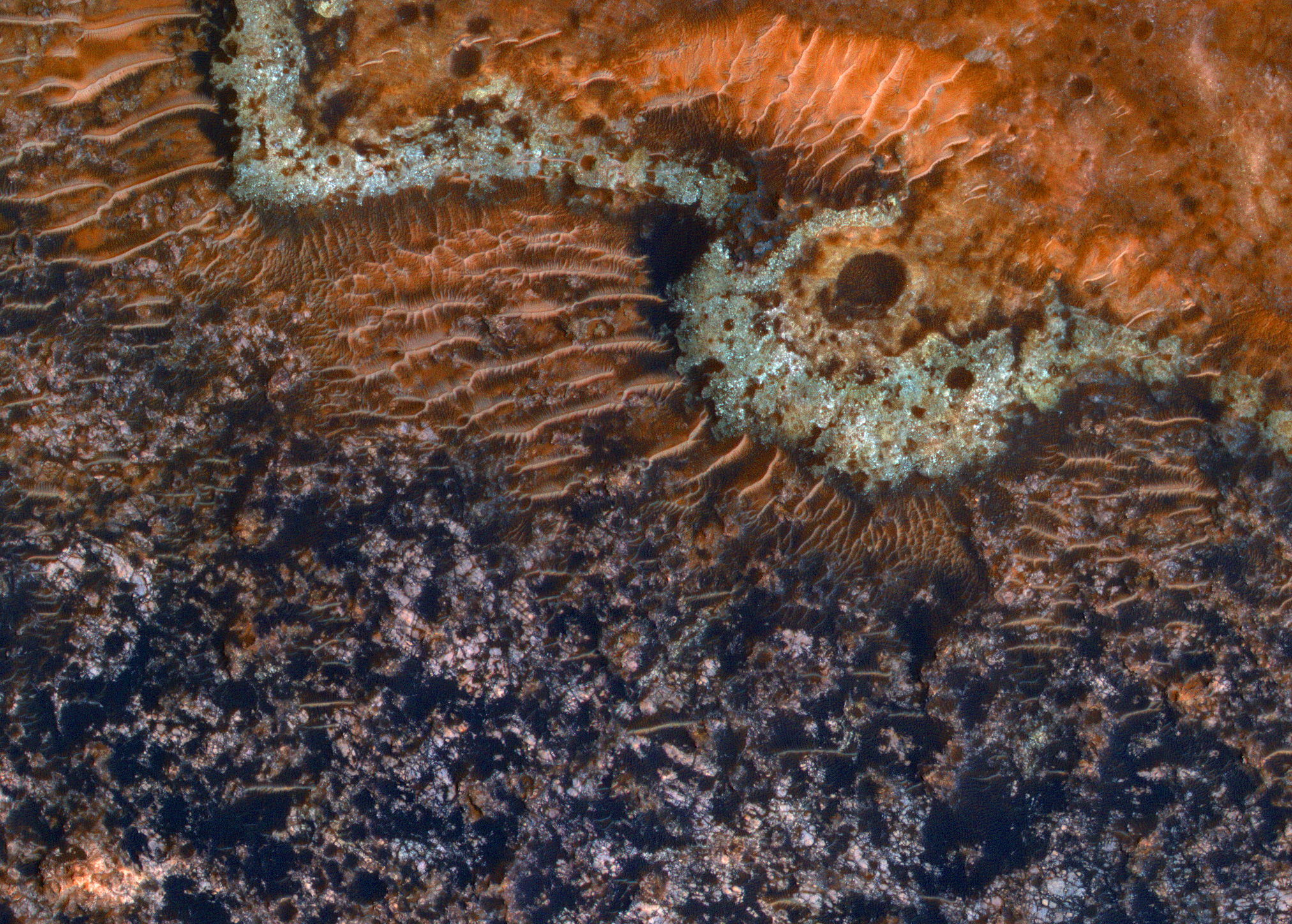
The entire area in this image has been recently crossed by multiple dust devils. This area was probably initially covered by a layer of bright dust.

Dust devils (small tornado-like vortices common in many places on Mars) then lifted the dust into atmospheric suspension as they moved along the surface, exposing darker, less dusty material below. Some areas in this image have more boulders than others, but the dust devil tracks cross them without being much affected.

Photo credit: NASA/JPL/University of Arizona

Note: The location of this image is just east of Wallace Crater, which itself is slightly to the southeast of Hellas Planitia.

Thursday, September 29, 2011

Rocas Coloridas en Terra Sabaea


Esta zona de las antiguas tierras altas australes ha sido modificada por la tectónica, es decir, por fallas y pliegues que afectan a las unidades de roca.

Esta imagen también es interesante vista a través de los colores de la HiRISE. Estos (mejorados en la subimagen) indican la variedad de minerales que hay presentes. Esta región fue objetivo del CRISM para estudiar con más detalle la detección de olivino que se había hecho previamente. El olivino, un mineral volcánico, da los colores verdes y azules que se aprecian en la imagen de la HiRISE.

Colorful Rocks in Terra Sabaea

This area of ​​the ancient southern highlands has been modified by tectonics, i.e., faults and folds that affect the rock units.

This image is also interesting view through the colors of the HiRISE. These (enhanced in the subpicture) indicate the variety of minerals that are present. This region was the target of CRISM to study in more detail the detection of olivine that had been done previously. Olivine, a volcanic mineral, giving the green and blue colors that are seen in the HiRISE image.

Photo credit: NASA/JPL/La Universidad de Arizona

Note: This location is about halfway between Hellas Planitia (which is due south) and Harris Crater, which is slightly to the north-northeast.

Monday, September 26, 2011

Small Mounds in Chryse Planitia


This HiRISE image shows a group of cones, shield-like features, and round mounds. They are a few hundred meters to kilometers in diameter. Possible origins include sedimentary (mud) volcanism and magmatic volcanism. HiRISE data are essential for evaluating these hypotheses.

Photo credit: NASA/JPL/University of Arizona

Note: This image is located in southern Chryse Planitia, north of the "mouth" of Simud Valles, and about halfway between the landing sites of Viking 1 and Pathfinder.

Sunday, September 25, 2011

Avire Crater Seasonal Monitoring


This crater shows prominent gullies on it walls. The origin of gullies is controversial, but many, and probably those here, seem to require carbon dioxide or water frost that may fluidize debris flows, or possibly water in an ephemeral (short term) stability state that erodes the surface.

This region is being continually monitored by HiRISE to note any changes.

Photo credit: NASA/JPL/University of Arizona

Note: Avire Crater is a tiny crater located in the much larger crater of Newton, itself located in the southern highlands' region of Terra Sirenum.

Saturday, September 24, 2011

Jumbled Terrain in Ius Chasma


This HiRISE image shows a mixture of bright and dark units. The bright units have a mineral called sulfate (salty sulfuric acid) that on Earth typically forms in the presence of water as an evaporite.

The brighter sulfates appear jumbled and folded, sometimes with sharp edges, inside a darker matrix of material. Either the sulfates were deposited this way, such as from a landslide that mixed and messed them up inside the darker material, or the sulfate was disrupted after it was deposited, perhaps from tectonic activity that broke it apart and folded it.

This is a stereo pair with PSP_006652_1725.

Photo credit: NASA/JPL/University of Arizona

Note: This image was taken in Ius Chasma, located roughly half-way between Melas Chasma to the east and Noctis Labyrinthus to the west.

Friday, September 23, 2011

Opportunity at Endeavour Crater


This image, taken by HiRISE, shows the Mars Exploration Rover Opportunity (at the end of the white arrow) sitting atop some light toned outcrops on the rim of Endeavour Crater.

Opportunity traveled nearly three years to reach this rim because it contains rocks even more ancient than the rocks of Meridiani Planum, which the rover has been exploring since 2004, and hence may teach us something about an even more ancient era in Martian history.

Photo credit: NASA/JPL/University of Arizona

Saturday, September 17, 2011

Iazu Crater


With Opportunity's arrival to the rim of Endeavour Crater, we prepare for our science activities by using HiRISE to perform a reconnaissance of the surrounding craters.

Not far to the south of Endeavour Crater lies Iazu Crater. The crater walls, which are better exposed than those of Endeavour, may provide a regional context for Opportunity's studies.

While it is in no way guaranteed that Opportunity will ever travel to Iazu Crater, the secrets revealed by taking this image may provide insight into the stratigraphy and structure of Endeavour Crater and help define the scientific campaign of Opportunity at Endeavour.

This is a stereo pair with ESP_022525_1775.

Photo credit: NASA/JPL/University of Arizona

Friday, September 16, 2011

Chester Lake


An outcrop informally named "Chester Lake" is the second rock on the rim of Endeavour crater to be approached by NASA's Mars Exploration Rover Opportunity for close inspection with instruments on the rover's robotic arm. This view of Chester Lake combines images taken through three different filters by Opportunity's panoramic camera (Pancam) and is presented in false color to emphasize differences among materials in the rock and soil. The component images were taken during the 2,709th Martian day, or sol, of Opportunity's work on Mars (September 7, 2011).

Chester Lake is about 3 feet (1 meter) across. It lies on the inboard (southeastern) side of a low ridge, "Cape York," which forms a portion of the western rim of Endeavour crater. Rover team scientists chose it for inspection because it is in-place bedrock that appears to be representative of a region of outcrops on the inboard side of Cape York.

Chester Lake differs from the first rock inspected by Opportunity on the Endeavour rim, "Tisdale 2," which is a boulder excavated during an impact event that produced a small crater on the rim. Both rocks appear to be breccia, a type of rock fusing together broken fragments of older rocks. By Sol 2713 (September 11, 2011), researchers had used Opportunity's microscopic imager and alpha particle X-ray spectrometer to study Chester Lake and were planning to use the rover's rock abrasion tool and, possibly, its Moessbauer spectrometer on the rock. They will use all the data to reconstruct the chemistry, mineralogy and geologic setting of Chester Lake, including evidence about whether or not the rock has any clay minerals in its composition.

Images combined into this view were taken through Pancam filters admitting light with wavelengths centered at 753 nanometers (near infrared), 535 nanometers (green) and 432 nanometers (violet).

Photo credit: NASA/JPL-Caltech/Cornell/Arizona State University

Note: For two other pictures of Chester Lake, see PIA14751: Shadow Across 'Chester Lake' on Endeavour Rim, Sol 2710 and PIA14753: 'Chester Lake' Bedrock on Rim of Endeavour Crater.

Thursday, September 15, 2011

Fan and Dust Devil in Deuteronilus Mensa


This image shows what appears to be a degraded alluvial fan at upper left and a dust devil at lower right.

An alluvial fan is deposited by a river flowing out onto a plain; if this feature was formed by water, the activity ceased long ago, based on the density of craters on the fan surface.

The dust devil, on the other hand, is an example of the ongoing processes that continue to shape the surface of Mars.

Photo credit: NASA/JPL/University of Arizona

Note: This location is in Deuteronilus Mensae, to the southwest of Lyot Crater.

Update: The above caption has been translated into Spanish and republished by the HiRise team:

Abanico y Remolino de Polvo en Deuteronilus Mensa

Esta imagen muestra lo que parece ser un abanico aluvial degradado en la parte superior izquierda y un remolino de polvo en la parte inferior derecha.

Un abanico aluvial se deposita a través de un rio que fluye hacia una llanura. Si el agua formó este abanico, la actividad cesó hace mucho tiempo si nos fijamos en la densidad de cráteres sobre su superficie.

El remolino de polvo, por otra parte, es un ejemplo de los procesos que hay actualmente en funcionamiento y que dan forma a la superficie de Marte.

Wednesday, September 14, 2011

Carbon Dioxide Ice in the Late Summer


Mars has extremely large temperature changes from winter to summer compared to the Earth. It gets cold enough to freeze carbon dioxide out of the atmosphere during the winter, but this ice is unstable when the warmer summer arrives and forces it to sublimate (transform directly back into a gas) away.

Near the South pole though, it stays cold enough for some of this seasonal ice to stick around all year and even accumulate from year to year. This image shows a portion of this permanent carbon dioxide ice cap. This slab of ice is a few meters (about 10 feet) thick and is penetrated by the flat-floored pits shown here. The quasi-circular pits in the center of the scene are about 60 meters (200 feet) across.

The distinct color of the pit walls may be due to dust mixed into the ice. For most of the year these walls are covered with bright frost, but they defrost and show their true colors at the end of the summer.

Photo credit: NASA/JPL/University of Arizona

Tuesday, September 13, 2011

Gullies and Lobate Material in a Crater in Nereidum Montes


This crater has gullies on its southwest-facing walls and rim, as well as and what appears to be two separate instances of lobate (ear-shaped) material associated to its interior gullies.

This observation is a "ride-along" with the CTX Camera, which has a much larger footprint, but lower resolution than the HiRISE camera.

With much better resolution than CTX, HiRISE may be able to provide insight into the relationship between the features.

This is a stereo pair with ESP_022540_1405.

Photo credit: NASA/JPL/University of Arizona

Note: This crater lies in the Nereidum Montes, which is the mountainous terrain to the northwest of Argyre Planitia.

Monday, September 5, 2011

Flow Structures in Noctis Region Trough


Noctis Labyrinthus, "the labyrinth of the night," sits at the western end of the largest canyon of the solar system, Valles Marineris. This image was taken to investigate the nature of this impact ejecta.

The wavy structures visible in the image center may have formed from this partly molten ejected material. The tectonic forces that opened this canyon also disrupted the crust in this location and led to the formation of many isolated blocks of rock with intervening valleys.

Later events have also left their mark on this maze-like landscape. The formation of 124 kilometer diameter (78 miles) Oudemans Crater to the east likely dumped ejected material on the area visible here.

This is a stereo pair with ESP_020735_1720.

Photo credit: NASA/JPL/University of Arizona

Sunday, September 4, 2011

New Impact Crater on Elysium Mons


Newly-formed impact craters on Mars are found (and dated) by comparing images before and after the impact and looking for changes.

There isn't a "before" image with sufficient quality and lacking this feature to date this impact event, but its appearance is similar to that of impacts formed in the past decade, except for a bit more modification by the wind, producing the bright wispy streaks trending east-west (left-right). It probably formed sometime in the past century.

This crater is 22 meters across and sits on the southwest edge of the Elysium Mons shield volcano.

Photo credit: NASA/JPL/University of Arizona

Saturday, September 3, 2011

Opaline Floor of Noctis Labyrinthus


The smooth light-toned deposits on the floor of Noctis Labyrinthus, a series of depressions at the westernmost end of Valles Marineris, may contain a form of hydrated silica, perhaps opal, which is a gemstone.

The opal could have formed by chemical weathering of basaltic lava flows or volcanic ash in the presence of water. Also visible in the left side of the enhanced-color subimage are sand dunes with two colors, perhaps due to dark sand covered in places by bright reddish dust, and an impact crater with dark ejecta. (The subimage width is 1.2 kilometers.)

This is a stereo pair with ESP_023003_1710.

Photo credit: NASA/JPL/University of Arizona

Friday, September 2, 2011

Enigmatic Mound on the Crater Floor on Margaritifer Terra


The origin of this mound on a crater floor was not clear from prior image coverage, so we targeted HiRISE to take a closer look. With study of the HiRISE image, the geologic history may or may not be clarified, but it is certainly a striking image.

The dark sand collected in low areas creates a high contrast with the lighter-toned bedrock, and there are caterpillar-like wind-blown dunes or ripples crawling over the surface. The subimage shows an enhanced-color view.

Photo credit: NASA/JPL/University of Arizona

Thursday, September 1, 2011

Tisdale 2


This rock, informally named "Tisdale 2," was the first rock the NASA's Mars Rover Opportunity examined in detail on the rim of Endeavour crater. It has textures and composition unlike any rock the rover examined during its first 90 months on Mars. Its characteristics are consistent with the rock being a breccia -- a type of rock fusing together broken fragments of older rocks. Tisdale 2 is about 12 inches (30 centimeters) tall.

Photo credit: NASA/JPL-Caltech/Cornell/Arizona State University

Note: A number of other photos have been released with regard to Tisdale 2; see PIA14745: Locations of Microscopic Imager Observations on 'Tisdale 2', PIA14746: Magnified View of Texture on Part of "Tisdale 2" Rock, PIA14747: Elevated Zinc and Bromine in Rock on Endeavour Rim, PIA14748: Approaching 'Tisdale 2' Rock on Rim of Endeavour Crater, Sol 2690, and PIA14749: Opportunity at Work Examining 'Tisdale 2,' Sol 2695.