Thursday, May 31, 2012

Sand Ripples West of Aeolis Planum


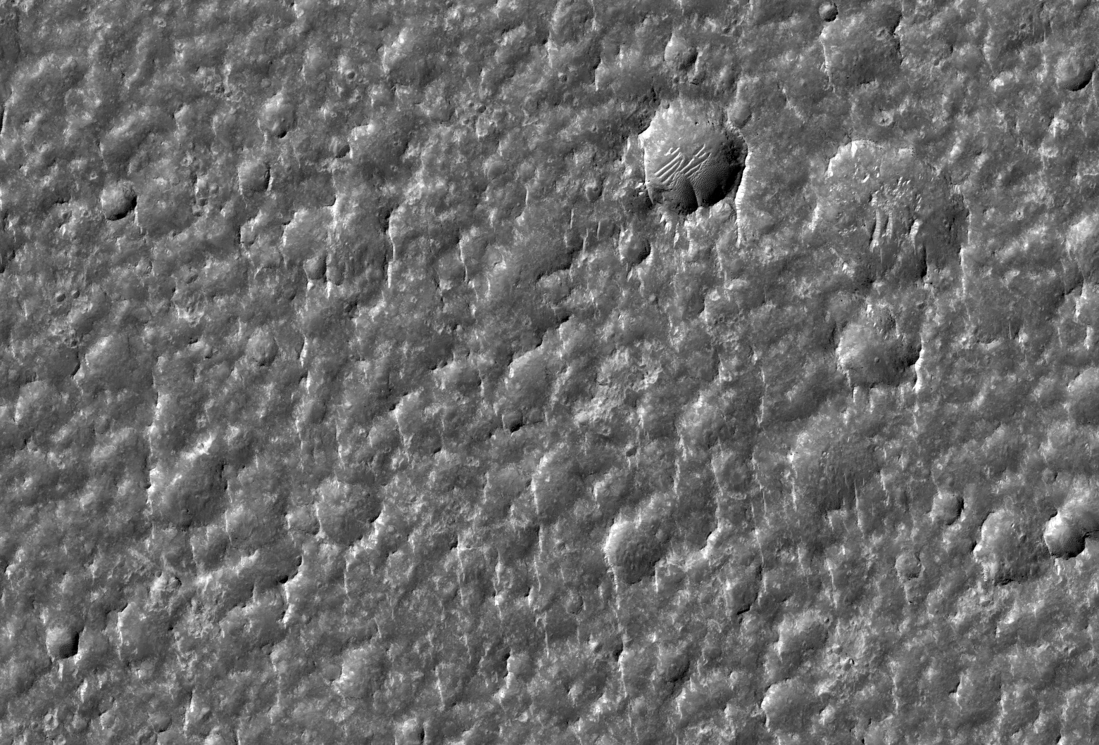
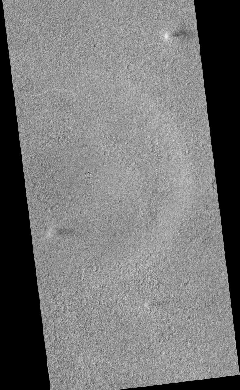
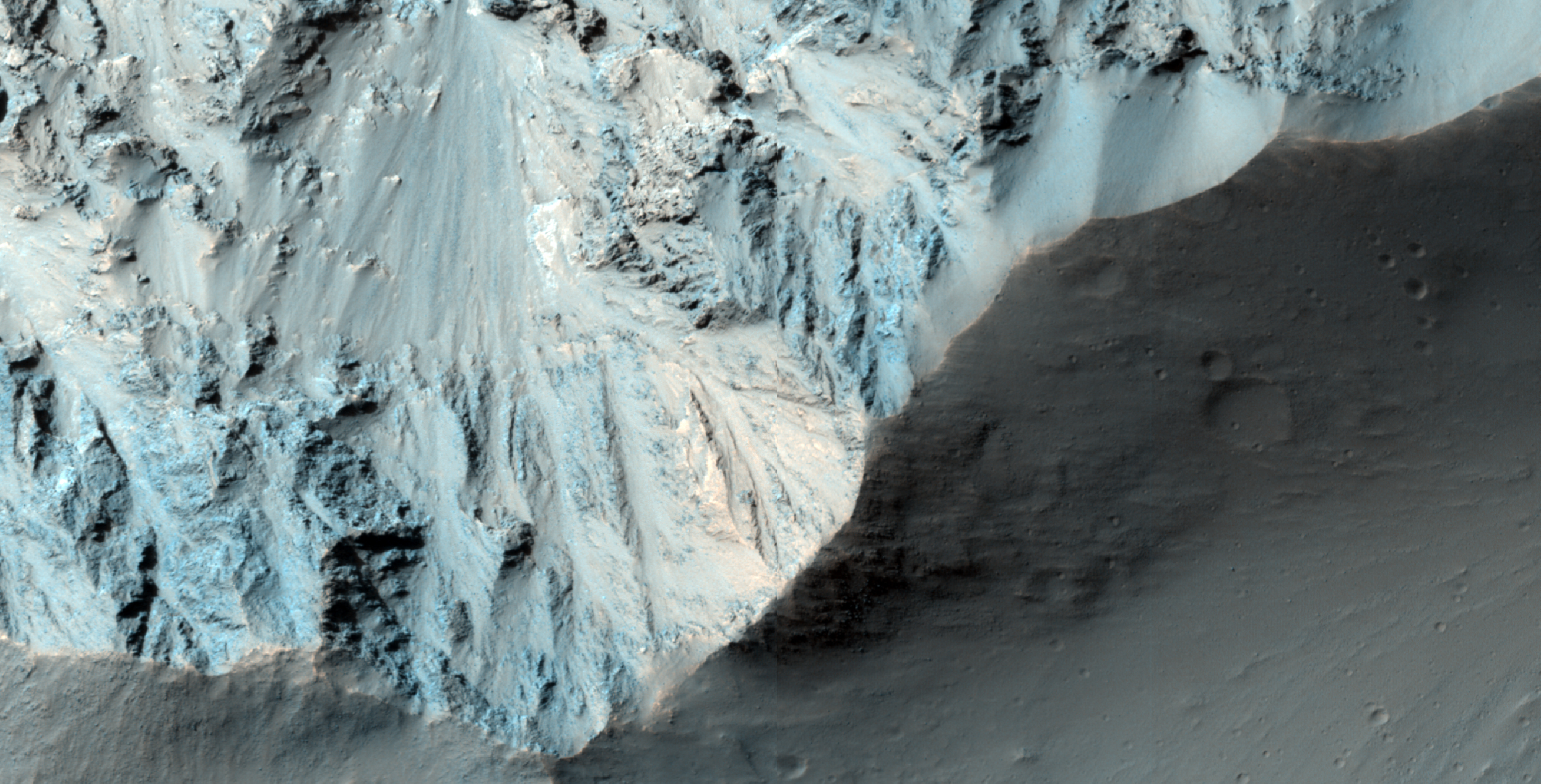
Landing of the surface of Mars requires extensive planning and imaging reconnaissance. This terrain west of Aeolis Planum is being considered as landing site for a future Mars mission.

The surface is relatively flat with numerous small-scale ridges and mounds. Some of these ridges curve and form the rims of old impact craters, now in various stages of erosion and largely filled with soil. However, most ridges have the appearance of a wind-driven landform called ripples. These features are about 10 yards wide and 100 yards long, and meander slightly but are generally oriented south to north.

Mounds are less distinct, but may also be aeolian (wind derived) in nature. Most of the "freshest" looking crater floors, those seeming least eroded, contain smaller characteristic sand ripples.

All of the craters appear eroded and heavily filled with a soil mantle. Even many of the ripples features appear mantled and smothered by soil. Nevertheless the occurrence of these aeolian bedforms (landforms that are formed by wind blown sand) suggest these surface soils are comprised of loose fine-grained regolith (rocks and fine rock fragments), which the wind has been able to move and organize.

Very few rocks or boulders are seen and those that are seen are largely limited to ejecta around some of the fresher appearing and larger craters. Although still heavily eroded and mantled, these rocky craters indicate more cohesive material such as bedrock or partially-cemented regolith exists beneath the loose soil cover. The absence of widely distributed rocks ejected from craters may suggest this area has experienced extensive, possibly ongoing, accumulation of soil, or that the subsurface rocks are weak and easily eroded by wind and windblown sand.

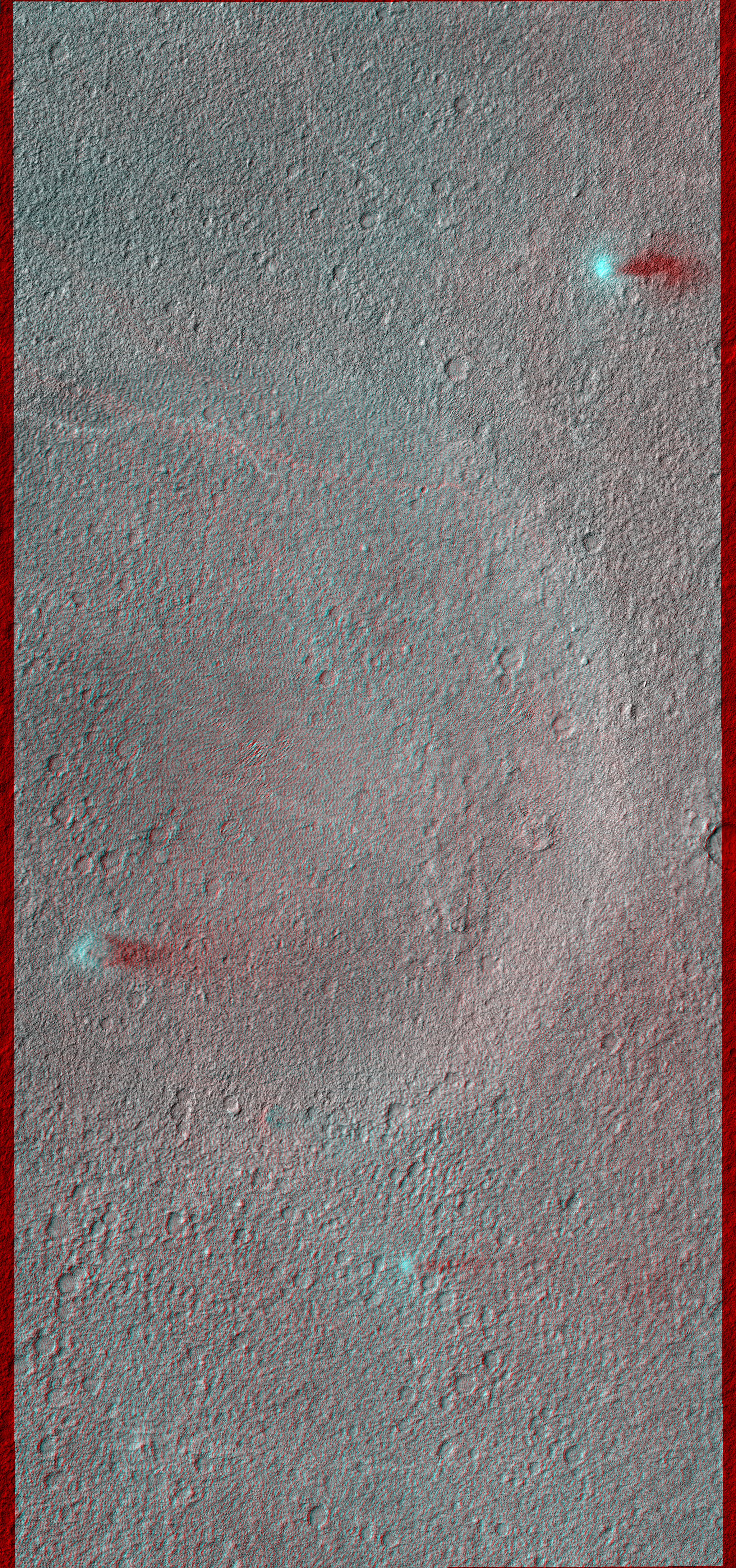
This is a stereo pair with ESP_027003_1790.

Photo credit: NASA/JPL/University of Arizona

Note: This site is located to the north of Aeolis Mensae and to the northeast of Gale Crater, where the Mars Science Laboratory (Curiosity) will be landing in August.

Wednesday, May 30, 2012

Streamlined Landforms near the Cerberus Fossae


One of the earliest observations of Mars that indicated that water once flowed across its surface was the presence of large streamlined landforms. Such landforms are carved by flowing fluids that erode islands into teardrop shapes.

While wind can also produce streamlined landforms (called yardangs), many features on Mars were clearly produced by a liquid that was confined to the low areas inside channels. There is an ongoing debate about the roles of lava and water in carving these features.

Streamlined forms visible inside channels on the Moon and Mercury must have been carved by lava since there is no plausible way water could have flowed over those bodies. On Mars, the HiRISE team is seeing a pattern where we believe most channels were carved by water but then covered with lava.

Observations like this one help us test the idea that the lava is simply coating a water-carved surface.

Photo credit: NASA/JPL/University of Arizona

Note: This site is located to the east of the southern-half of the Tartarus Montes chain.

Tuesday, May 29, 2012

Breccia with Large Clasts in Candor Chasma


In this beautiful image there appears to be a breccia layer, or a layer composed of rock fragments embedded in a finer material. This particular breccia is made up of fragments (or "clasts" as they are known to geologists) so large they can be seen by HiRISE.

The breccia layer, seen most easily near the center of this image, seems to be more resistant to erosion than the surrounding material, serving as a caprock to protect the layers beneath it.

The HiRISE team is planning on acquiring another image over this area in order to create a stereo (3-D) pair. This will help scientists better understand the topography and stratigraphy of the area.

This is a stereo pair with ESP_026523_1735.

Photo credit: NASA/JPL/University of Arizona

Note: This image is located in western Candor Chasma to the east of Ceti Mensa.

Monday, May 28, 2012

In the Transition Zone in Deuteronilus Mensae


Nestled between mesas, this image shows the valley floor where eroded rocky and/or soil debris appears to have flowed viscously from the mesa walls across the valley to merge. A leading theory is that ice and snow became entrained with the soil debris as it shed from the mesa. This combined ice-rich debris then flowed slowly downhill. "Rock glaciers" on Earth are an analogous landform that flow viscously like a glacier, lubricated by ice trapped in the pore spaces.

The image shows light-toned viscous debris that overlays a darker toned surface. Both surfaces sport irregular fracture patterns and evidence that substantial erosion has since taken place. The upper viscous-flow surface also contains abundance small, regular polygonal patterns. Such patterns are commonplace in permafrost on Earth, and are typically considered strong evidence for shallow subsurface ice.

Erosion and the formation of small scarps reveal a multitude of layers within the subsurface. Such structure is unusual for a single glacial flow and may indicate episodic glacial advance and retreat. Additionally, the sparse population of rocks on the surface and along the eroded scarps suggest that the debris eroding from the mesas consists largely of soil.

Photo credit: NASA/JPL/University of Arizona

Note: This image is located in Deuteronilus Mensae, about half-way between Lyot Crater to the north and Sinton Crater to the south, in Arabia Terra.

Sunday, May 27, 2012

Da Vinci-Mars Design

I don't receive many comments on this blog, and it's extremely rare for me to promote other non-official websites here, but I think readers of Areology will greatly enjoy Da Vinci-Mars Design. This is an art blog by Ludovic Celle about Mars using Kim Stanley Robinson's Mars trilogy as inspiration. The artwork here is very good, and I hope to get through all of Ludo's posts soon. What I have seen so far is very impressive. Please give Ludo your support!

A Trough within Ladon Basin


This image shows an approximately 2-kilometer wide trough within Ladon Basin. This trough, and others around the perimeter of the basin, were probably produced during the gradual sinking of the materials here.

The basin formed during an epoch in Martian history called the Noachian period, and may have harbored a lake based upon the fluvial valleys that flow into it. If a lake once existed here then the trough is a window that could expose any sediments deposited within the lake, making this an exciting image to explore.

Photo credit: NASA/JPL/University of Arizona

Note: Ladon Basin is not a formally named feature on Mars; however, it is located in southwestern Margaritifer Terra. Ladon Valles (the only Martian feature with the Ladon name) looks to have flowed north into the southern end of the impact basin; however, this trough is far to the northwest of that outflow channel.

Saturday, May 26, 2012

Expanded Craters on Icy Terrain in Tantalus Fossae


The middle of this image contains a cluster of depressions (craters) with two levels: a small inner crater, surrounded by a shallow depression extending outward from the inner crater.

This image is located at 50 degrees north latitude, where shallow ice has been mapped by the Mars Odyssey spacecraft. MRO has detected newly-formed impact craters in this broad region that exposed shallow ice, and also revealed that it is nearly pure ice.

One interpretation of the expanded craters visible here is that a group of small impacts, probably secondary craters from a much larger primary crater, exposed the clean, shallow ice in this region. Once exposed, the ice is unstable and sublimates (passes directly from ice to gas), and the shallow depressions could gradually expand.

Photo credit: NASA/JPL/University of Arizona

Note: This crater is located in eastern Tantalus Fossae to the northwest of Tempe Terra.

Friday, May 25, 2012

Late Afternoon Shadows at Endeavour Crater


NASA's Mars Rover Opportunity catches its own late-afternoon shadow in this dramatically lit view eastward across Endeavour Crater on Mars.

The rover used the panoramic camera (Pancam) between about 4:30 and 5:00 p.m. local Mars time to record images taken through different filters and combined into this mosaic view.

Most of the component images were recorded during the 2,888th Martian day, or sol, of Opportunity's work on Mars (March 9, 2012). At that time, Opportunity was spending low-solar-energy weeks of the Martian winter at the Greeley Haven outcrop on the Cape York segment of Endeavour's western rim. In order to give the mosaic a rectangular aspect, some small parts of the edges of the mosaic and sky were filled in with parts of an image acquired earlier as part of a 360-degree panorama from the same location.

Opportunity has been studying the western rim of Endeavour Crater since arriving there in August 2011. This crater spans 14 miles (22 kilometers) in diameter, or about the same area as the city of Seattle. This is more than 20 times wider than Victoria Crater, the largest impact crater that Opportunity had previously examined. The interior basin of Endeavour is in the upper half of this view.

The mosaic combines about a dozen images taken through Pancam filters centered on wavelengths of 753 nanometers (near infrared), 535 nanometers (green) and 432 nanometers (violet). The view is presented in false color to make some differences between materials easier to see, such as the dark sandy ripples and dunes on the crater's distant floor.

Photo credit: NASA/JPL-Caltech/Cornell/Arizona State University

Note: For more information, see Dark Shadows on Mars: Scene from Durable NASA Rover.

Friday, May 18, 2012

Monitoring Dune Gullies in Matara Crater


There are landforms called "gullies," consisting of an alcove, channel, and apron, on many large sand dunes on Mars.

Remarkably, we have learned that the gullies form primarily or entirely during seasons when there is carbon dioxide frost on the ground. To understand this better we image key locations multiple times throughout the Martian year.

This image, at 49.5 S latitude, was acquired very near the winter solstice, when shadows are very long in the middle afternoon when MRO passes overhead. Dark sand inside shadows is a challenging scene to image while flying overhead at 3.4 km/sec, but the HiRISE camera has the sensitivity needed to acquire useful images even at the most challenging time of the year.

The subimage shows one of these gullies, hidden in the shadow. Vertical stripes in the image are from electronic noise that is usually hidden by the image signal, but in this case the signal is extremely low.

Photo credit: NASA/JPL/University of Arizona

Note: This image is located in Matara Crater, which is to the southwest of Hellas Planitia in Noachis Terra.

Thursday, May 17, 2012

A Youthful Crater in Cydonia Colles


This observation shows a youthful crater with sharp rim and gullied slopes.

Just what makes a Martian crater youthful, in a geologic sense? Very old craters tend to have eroded rims and can have plenty of material that's filled in the floor. Gale Crater, where the Mars Science Laboratory will land this summer, is an example of an ancient, highly eroded crater. By contrast, the crater in this image appears to have experienced much less erosion.

Note that even though a crater might be called "youthful," it can still mean that the crater formed tens of thousands of years ago, if not more. For an example of a truly recent crater, see the 7 meter (about 23 feet) diameter crater in ESP_015989_1835, which we know formed sometime between 2005 and 2010.

Note: the above image is not map-projected, so North is down.

Photo credit: NASA/JPL/University of Arizona

Note: This crater is located in Cydonia Colles, which is located in Acidalia Planitia to the north of Arabia Terra. This crater is an extremely short distance south of Apt Crater.

Wednesday, May 16, 2012

Advancing Dune in Nili Patera


Back-and-forth blinking of this two-image animation shows movement of a sand dune on Mars. The images are part of a study published by Nature on May 9, 2012, reporting movement of Martian sand dunes at about the same flux (volume per time) as movement of dunes in Antarctica on Earth.

The before-and-after images were taken nearly three Earth years apart by the High Resolution Imaging Science Experiment (HiRISE) camera on NASA's Mars Reconnaissance Orbiter. The scale bar is 50 meters (164 feet). The site is part of a dune field inside the summit caldera of Nili Patera, an ancient volcano, at 8.7 degrees north latitude, 67.3 degrees east longitude.

The images show a dark, rippled sand dune overlying bright-toned rock. They have been "orthorectified," that is, adjusted such that they appear as if viewed from directly overhead. They were then positionally tied together by registering fixed features on the bedrock seen in one image to the same features seen in the other. When the images are blinked back and forth, advance of the dune's lee (downwind) front over the time period of 941 days is clearly seen in the area indicated by the arrow near the lower-left corner. Other arrows indicate places where the margin of the dune has moved. In contrast, the ripples have changed so much that their migration cannot be tracked.

The first image, in which the main body of the dune looks darker due to lighting effects, was taken on October 13, 2007. It is one image product of HiRISE observation PSP_005684_1890. Other image products from the same observation are at http://hirise.lpl.arizona.edu/PSP_005684_1890. The "after" image was taken on May 11, 2010. Other image products from the same HiRISE observation are at http://hirise.lpl.arizona.edu/ESP_017762_1890.

Photo credit: NASA/JPL-Caltech/Univ. of Arizona/JHU-APL

Note: For a similar animation also located at Nili Patera see PIA15680: Ripple Movement on Sand Dune in Nili Patera, Mars. Also, see NASA Spacecraft Detects Changes in Martian Sand Dunes. For an abstract of the Nature article plus additional images, see Science in Motion.

Tuesday, May 15, 2012

Leaving Greeley Haven


NASA's Mars Exploration Rover Opportunity drove about 12 feet (3.67 meters) on May 8, 2012, after spending 19 weeks working in one place while solar power was too low for driving during the Martian winter. The winter worksite was on the north slope of an outcrop called Greeley Haven. The rover used its rear hazard-avoidance camera after nearly completing the May 8 drive, capturing this view looking back at the Greeley Haven. The dark shape in the foreground is the shadow of Opportunity's solar array. The view is toward the southeast.

Since landing in the Meridiani region of Mars on January 25, 2004, Universal Time and EST (January 24, PST), Opportunity has driven 21.4 miles (34.4 kilometers).

Opportunity and its rover twin, Spirit, completed their three-month prime missions on Mars in April 2004. Both rovers continued for years of bonus, extended missions. Both have made important discoveries about wet environments on ancient Mars that may have been favorable for supporting microbial life. Spirit stopped communicating in 2010.

Photo credit: NASA/JPL-Caltech

Note: For more information, see Opportunity Rolling Again After Fifth Mars Winter.

Monday, May 14, 2012

Naar Crater


This impressive crater, that stretches well across the width of the HiRISE camera's footprint, is notable for its sharp rim and steep walls.

There are also some interesting features on the crater floor, not to mention the ejecta blanket, the material surrounding the crater as a result of the original impact. In fact, when viewing this area with other images that have a wider range of view than HiRISE, the ejecta blankets for the craters located here take on the appearance of a flower.

This pattern of ejecta is common with Martian craters. The distinct sharp ends to the flower shaped ejected has led many scientists to suggest that water and ice were engulfed in the ejecta as it was thrown from the crater.

The crater is named after a town in Egypt.

Note: the above image is not map-projected, so North is down.

This is a stereo pair with PSP_007046_2030.

Photo credit: NASA/JPL/University of Arizona

Note: Naar Crater is located in Chryse Planitia.

Sunday, May 13, 2012

A Youthful Crater in Acidalia Planitia


In this image, we can clearly see the ejecta of this crater, and that tells us the crater appears young and well-preserved. "Ejecta" refers to the material that is excavated from an initial impact and settles back to the surface.

One way we describe a crater as being young is to observe the crater rim. If the rim of a crater doesn't appear that eroded, we often call it "sharp" and "young," even though the impact may have occurred an extremely long time ago.

Given the latitude and proximity to gullies on mesas and massifs in this region, there could also be mid-latitude-type gullies in this crater. At HiRISE resolution, we can get a better look at the ejecta, its distribution and possibly characterize any subsequent modifications we can see in the crater walls.

Photo credit: NASA/JPL/University of Arizona

Note: This crater is located in Acidalia Planitia; it is west of Acidalia Colles and almost due north of Bonestell Crater.

Saturday, May 12, 2012

Sculpting Dunes in Ganges Chasma


When dunes are located in a complex topographical area such a canyon, they become ideal candidates for detecting changes to their shapes and sizes over time.

The dunes here in Ganges Chasma--a canyon that's on the eastern end of Valles Marineris--could be strongly influenced by winds, and it's important not to underestimate the erosional power of wind. Because HiRISE has such good resolution, we can track these changes over time to tell us which way a dune is moving, how much, and in what direction. From these observations we can decipher present-day atmospheric processes.

Photo credit: NASA/JPL/University of Arizona

Friday, May 11, 2012

Frosted Ground in Noachis Terra in Late Autumn


This image was acquired within two weeks of the winter solstice, when the subsolar latitude is at its northernmost position.

At this location (latitude 52 S) and time the Sun barely peeks over the horizon in the mid-afternoon when MRO passes overhead, and carbon dioxide frost is building up on most of the surface.

In enhanced color, the frost appears blue. Slopes that face north receive more heat from the Sun and appear reddish, indicating less frost is present. There may also be a small amount of water frost on the surface.

Mars is very different from Earth in that its main atmospheric component can condense onto the surface. The nitrogen that dominates Earth's atmosphere never condenses onto the surface, although nitrogen in the atmospheres of frigid Triton and Pluto do form surface frost and ice.

Photo credit: NASA/JPL/University of Arizona

Note: This image is located in Noachis Terra, roughly halfway between Hellas Planitia and Argyre Planitia; the closest named feature is Russell Crater, which lies to the southwest.

Tuesday, May 8, 2012

Acidalia Planitia and Tempe Terra


The transition between Acidalia Planitia and Tempe Terra is shown here in a computer-generated perspective view. The image was created using data obtained from the High-Resolution Stereo Camera (HRSC) on ESA’s Mars Express spacecraft. Centered at around 37°N and 306°E, this image has a ground resolution of about 15 m per pixel. The foreground craters are believed to come from a younger phase in Mars history, evidenced by a lack of erosion and infilling seen in the background craters, which are believed to have once held liquid water.

Image credit: ESA/DLR/FU Berlin (G. Neukum)

Note: Just to be clear, Tempe Terra is the higher ground on the left, and Acidalia Planitia is the lower ground to the right in the image.

Monday, May 7, 2012

Colorful Uplifted Rocks in Acidalia Planitia


Large impact craters have central regions of uplifted bedrock, a rebound effect following the tremendous energy of a hypervelocity impact. This produces windows into the deep and more ancient geologic history.

Central peaks on Mars have some of the most diverse and distinctive rock types. In this enhanced-color subimage we see two distinctive bedrock colors--light blue and purple--plus reddish to black fine-grained materials covering some of the rock. These rocks are generally massive or jumbled, and do not show regular layers like lava flows or water-lain sediments. One possibility is that these are plutonic rocks, where molten rock solidified at depth rather than erupted onto the surface as lava flows or particles.

Analysis of the CRISM spectra here should provide further clues. This spot is in the vast northern plains, where some workers believe there was an ancient ocean. So far, the mineralogic signature of ocean-deposited sediments has not been reported.

Photo credit: NASA/JPL/University of Arizona

Note: This crater is located in Acidalia Planitia; the closest named feature is Davies Crater, which lies some distance to the southwest.

Sunday, May 6, 2012

Dust Devil in Amazonis Planitia


There are three active dust devils in this image, but they aren't monsters like this picture.

Especially interesting is the stereo anaglyph with ESP_026051_2160, acquired just two weeks after this one.

Viewed with red-green glasses, the active dust devils seem to float above the surface. There are also some bright lines present in only the later image--those are the tracks of dust devils that passed through this region in the prior two weeks.

This is a stereo pair with ESP_026051_2160.

Photo credit: NASA/JPL/University of Arizona

Saturday, May 5, 2012

Layered Bedrock in Nili Fossae Region


The Nili Fossae region contains some of the best exposures of ancient bedrock on Mars.

Ancient bedrock can be tilted, folded, and generally complicated and difficult to understand, but the center of this image shows a stack of nearly horizontal layers. These layers might record how the environment on ancient Mars changed over time, and would be a good site for future exploration by a rover.

The differing colors indicate different rock types of alteration. The darkest patches of ground probably consist of volcanic sand that is trapped in relative low areas. The reddest patches may be covered by dust.

Photo credit: NASA/JPL/University of Arizona

Friday, May 4, 2012

A Flow Margin in Phlegra Dorsa


These HiRISE images form a stereo pair to examine the topography of the margin of a flow.

The Phlegra Dorsa region consists of ancient hills that have been surrounded and partially buried by flows from the Cerberus Fossae to the south. These flows could have been mud-laden water floods or very large lava flows.

The margin visible here is similar to that on lava flows that have had a long history of liquid lava being injected underneath the solidified crust. Relatively fresh impact craters and recent dust devil tracks are also visible in this image.

The second half of this stereo pair has another well-known formation.

This is a stereo pair with ESP_026461_2080.

Photo credit: NASA/JPL/University of Arizona

Thursday, May 3, 2012

Tractus Catena


Tractus Catena was imaged during orbit 9538 of Mars Express by the HRSC camera. Centered at around 23°N and 103°W, this 3D image has a ground resolution of about 22 m per pixel.

Image credit: ESA/DLR/FU Berlin (G. Neukum)

Wednesday, May 2, 2012

How Did Valles Marineris Form?


This image (and its companion for stereo) crosses an impact crater about 50 kilometers (30 miles) wide. The crater was visible in Mariner 9 and Viking Orbiter images acquired decades ago, and was interpreted as evidence that the floor of Coprates Chasma was an old surface like that of the surrounding plateaus north and south of the canyon, and had dropped more than 10 kilometers (6 miles) as a huge intact block of crust.

However, this image and others acquired by MRO reveal a geologically young crater, with far fewer superimposed craters than the high plateaus, and well-preserved primary impact morphologies. This crater must have formed after the opening of Valles Marineris, and is not evidence, by itself, that this portion of the canyon system formed from simple downdrop of a giant intact block.

The opening of Valles Marineris did involve crustal spreading and faulting, but may have had a more complex history. Many of the large landslides in Valles Marineris could have been triggered by this impact event.

Photo credit: NASA/JPL/University of Arizona

Tuesday, May 1, 2012

Folded Layers in Melas Chasma


There are folded layered deposits in the southern half of this image. How did this folding occur? On Earth, rocks are commonly folded when deeply buried and subject to high heat and pressure, which can make any rock flow. Such deep burial (and re-exposure or exhumation) is unlikely at this location.

In general Mars has experienced much less vertical motion of geologic strata than on Earth. Another possibility is that these layers were soft and deformable near the surface, such as wet or icy sediments. There are other folded layers in the giant Hellas impact basin, such as ESP_025780_1415.

Please get out your 3D glasses for a look at the stereo anaglyph here.

This is a stereo pair with ESP_025811_1700.

Photo credit: NASA/JPL/University of Arizona