Wednesday, September 19, 2012

New Impact Crater South of Echus Chasma


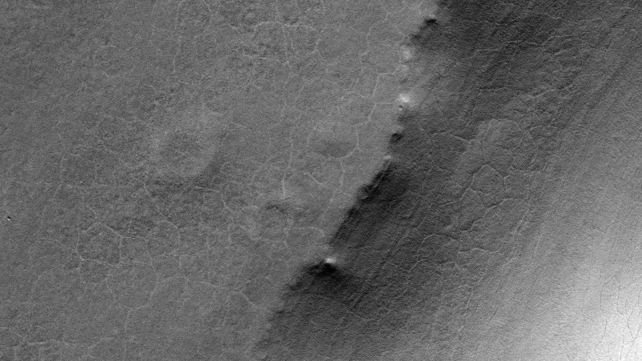
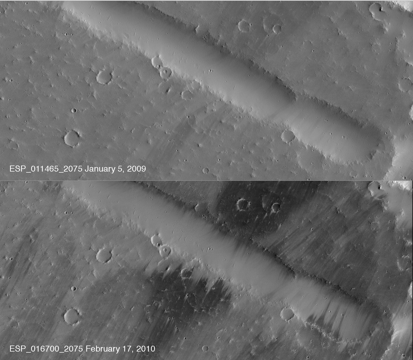
How exactly can we tell if an impact crater is new?

In this observation, we see a dark spot with a larger, rayed "blast zone" that was also apparent in a Context Camera image taken in 2011 (an instrument with a larger footprint than HiRISE and also on the Mars Reconnaissance Orbiter). However, a THEMIS image of the same area acquired in 2009 does not show the dark spot at all.

This is a great example of using three different instruments to view the same area not only to look for changes in the Martian landscape, but also to use the resolution of HiRISE to determine if this is indeed a new impact site.

Photo credit: NASA/JPL/University of Arizona

Note: This impact crater is located just south of Echus Chasma.

Tuesday, September 18, 2012

Bright and Dark Slope Streaks in Arabia Terra


While HiRISE has imaged slope streaks before, bright streaks are not as common as dark ones, so they're of high interest.

Slope streaks are generally small features, and have an interior roughness that is finer than the width of the streak itself. A high resolution image can help identify the characteristics of this roughness.

Additionally, studying these streaks can shed light on the "life cycle" of a streak and the geologic processes that created them. We may also be able to study the photometric properties of the streaks.

(Note: the above image is not map-projected, so north is approximate down).

Photo credit: NASA/JPL/University of Arizona

Monday, September 17, 2012

Pedestal Crater in Malea Planum


As the name suggests, pedestal craters usually have ejecta (material thrown out from impact) that is above the surrounding terrain. In some cases, the material can be more erosion-resistant. Some suggest that these units were once rich in volatiles (e.g., water ice).

This specific pedestal in Malea Planum is one of the largest on Mars, and fine layering is visible along its margins.

Photo credit: NASA/JPL/University of Arizona

Sunday, September 16, 2012

Dune Migration in Vastitas Borealis


This image shows large sand dunes in the North Polar sand sea on Mars. It is one of a series of repeat images of the same dunes, taken at different times, in order to determine the type and extent of changes in the dunes over time.

Dunes tend to migrate slowly on Earth under continuous wind regimes (on the order of several to tens of meters per year), and we are just starting to verify movement on Martian dunes with these repeat HiRISE images.

In addition to migration of the dune, we will also use these repeat images to look for changes in the dune shape and avalanches down the slip face. Analyzing these changes will help us better understand the interaction between the atmosphere and the surface of Mars.

Photo credit: NASA/JPL/University of Arizona

Saturday, September 15, 2012

Unusual Spherules at Cape York


Small spherical objects fill the field in this mosaic combining four images from the Microscopic Imager on NASA's Mars Exploration Rover Opportunity. The view covers an area about 2.4 inches (6 centimeters) across, at an outcrop called "Kirkwood" in the Cape York segment of the western rim of Endeavour Crater. The individual spherules are up to about one-eighth inch (3 millimeters) in diameter.

The Microscopic Imager took the component images during the 3,064th Martian day, or sol, of Opportunity's work on Mars (September 6, 2012). For a color view of the Kirkwood outcrop as Opportunity was approaching it two weeks earlier, see PIA16128.

Opportunity discovered spherules at its landing site more than eight-and-a-half years earlier. Those spherules were nicknamed "blueberries." They provided important evidence about long-ago wet environmental conditions on Mars because researchers using Opportunity's science instruments identified them as concretions rich in the mineral hematite deposited by water saturating the bedrock. A picture of the "blueberries" from the same Microscopic Imager is PIA05564.

The spherules at Kirkwood do not have the iron-rich composition of the blueberries. They also differ in concentration, distribution and structure. Some of the spherules in this image have been partially eroded away, revealing concentric internal structure. Opportunity's science team plans to use the rover for further investigation of these spherules to determine what evidence they can provide about ancient Martian environmental conditions.

Photo credit: NASA/JPL-Caltech/Cornell University/USGS/Modesto Junior College

Note: For more information, see NASA Mars Rover Opportunity Reveals Geological Mystery.

Wind Streaks Northwest of Unranius Tholus


This image of a wind streak monitoring site northwest of Uranius Tholus shows dramatic differences from earlier images and evidence for two distinct processes of Martian wind erosion.

Located near the northern end of the Tharsis rise at a moderate elevation (1800 meters above datum), the site is in a region of high albedo and low thermal inertia that suggest a thick mantle of dust. The first subimage shows some of the changes that have occurred since the site was last imaged in January, 2009 (ESP_011465_2075). Bright dust has been scoured from the surface by strong southerly winds (blowing from the top right in these unprojected images). Bright streaks trail downwind from impact craters, protected from the wind in the lee of the crater rims. Sharp dark streaks edged upwind as the dust was stripped away. At least two different episodes of erosion with slightly different wind directions can be inferred from the orientations of the dark streaks. Yet another wind direction is indicated by the few dune-like ripples that can be seen in the floor of the valley. These features were shaped by much older winds that were probably controlled by local topography.

The second subimage shows the second erosion process, the tracks of dust-devils across the newly cleaned surface (just south of the first subimage). What makes these tracks interesting is that they are bright! Most dust-devil tracks on Mars are dark, forming when a whirlwind lifts bright dust off the surface and exposes a darker substrate. These tracks were neither visible in the earlier HiRISE image, nor in an earlier image (PSP_002222_2075) acquired in January, 2007. The cause of the bright tracks is unclear.

Bright dust-devil tracks were also spotted by the Mars Orbital Camera in southern Schiaparelli Crater, a region also dominated at the time by wind streaks. One way to make bright tracks would be to excavate through dark material (such as a lag of basaltic sand) to a brighter substrate. Another possibility is that the dust-devils stir up the remaining pockets of bright dust that are hiding from the prevailing winds in the shelter of topographic obstacles.

Photo credit: NASA/JPL/University of Arizona

Friday, September 14, 2012

Colorful Surface Near Nili Fossae


This enhanced-color image shows a surface with diverse colors just southwest of Nili Fossae. The color diversity of this mesa suggests that the surface has a varied composition, perhaps recording chemical processes of ancient Mars.

Much of the surface shows a chaotic mix of colors, but the northern impact crater exposes distinct layers. Different layers have different colors. There are several possible reasons for this: the events that formed the layers could have drawn material from different sources, or the layers could have been altered differently after they formed, for reasons such as varying porosity.

This is a stereo pair with ESP_019898_2000.

Photo credit: NASA/JPL/University of Arizona

Thursday, September 13, 2012

Mounds in Chryse Planitia


The mounds in this observation may have been formed by a process called "diapirism," where material at depth is more buoyant (i.e., lower density) than the surrounding rocks so it rises to the surface.

Why might this be of interest? At HiRISE resolution, we might be able to study the uplifted material more closely, such as if there are clays or other aqueous materials present. If these mounds were formed by diapirism, it offers a deeper window into the Martian past. This area could also be an interesting site for a future exploration rover.

This is a stereo pair with ESP_026284_2060.

Photo credit: NASA/JPL/University of Arizona

Wednesday, September 12, 2012

Let it snow, let is snow, let it...


Observations by NASA's Mars Reconnaissance Orbiter have detected carbon-dioxide snow clouds on Mars and evidence of carbon-dioxide snow falling to the surface.

Deposits of small particles of carbon-dioxide ice are formed by snowfall from carbon-dioxide clouds. This map shows the distribution of small-grain carbon-dioxide ice deposits formed by snowfall over the south polar cap of Mars. It is based on infrared measurements by the Mars Climate Sounder instrument on the Mars Reconnaissance Orbiter.

Image credit: NASA/JPL-Caltech

Note: For more information, see NASA Observations Point to 'Dry Ice' Snowfall on Mars.

Tuesday, September 11, 2012

3-D View from Bradbury Landing


This 3-D image from NASA's Curiosity was taken from the rover's Bradbury Landing site inside Gale Crater, Mars, using the left and right eyes of its Navigation camera. Between the rover on the right, and its shadow on the left, looms the rover's eventual target: Mount Sharp. The mountain's highest peak is not visible to the rover from the landing site.

This full-resolution, 360-degree stereo panorama was taken on sols 2 and 12 of the mission, or the 2nd and 12th Martian days since landing (Aug. 8 and 18, 2012). It requires viewing with the traditional red-blue 3-D glasses, with red going over the left eye.

Image credit: NASA/JPL-Caltech

Monday, September 10, 2012

The MSL Sky Crane Crash Site by HiRise


After a rocket-powered descent stage, also known as the sky crane, delivered NASA's Curiosity rover to Mars on August 5 PDT (August 6 EDT), 2012, it flew away and fell to the surface. Possible multiple impacts from that collision are revealed in blue in this enhanced-color view taken by the High-Resolution Imaging Science Experiment (HiRISE) camera on NASA's Mars Reconnaissance Orbiter.

The main crash site is seen at right, shaped like a fan. Farther from the site are several smaller dark spots, which are thought to be secondary impacts from debris that continued to travel outward. The impact sites are darker because the lighter, reddish top layer of soil was disturbed, revealing darker basaltic sands underneath.

The full image for these observations can be seen at http://uahirise.org/releases/msl-tracks.php.

Photo credit: NASA/JPL-Caltech/Univ. of Arizona

Sunday, September 9, 2012

Opportunity's Surroundings on its 3,000th Sol


This 360-degree panorama assembled from images taken by the navigation camera on NASA's Mars Exporation Rover Opportunity shows terrain surrounding the position where the rover spent its 3,000th Martian day, or sol, working on Mars (July 2, 2012). Opportunity completed its 90-sol prime mission in April 2004. It has continued to explore the Meridiani Planum region of Mars for more than eight years of bonus extended missions.

The Sol 3000 site is near the northern tip of the Cape York segment of the western rim of Endeavour Crater. Bright toned material lines the perimeter of Cape York.

This panoramic view is centered to the south, with north at both ends. The component images were taken during sols 2989 through 2991.

Opportunity arrived at this location on Sol 2989 (June 20, 2012) with a drive bringing the mission's total driving distance as of Sol 3000 to 21.432 miles (34,492 meters). Here it examined a rock target called "Grasberg" with its microscopic imager and alpha particle X-ray spectrometer, both before and after grinding the surface off the target with the rover's rock abrasion tool. Opportunity departed this location with an eastward drive of about 105 feet (32 meters) on Sol 3008 (July 10, 2012).

The scene is presented as a cylindrical projection in this image.

Photo credit: NASA/JPL-Caltech

Note: For other images from this location, see: PIA16123: Opportunity's Surroundings on 3,000th Sol, in 3-D, PIA16124: Opportunity's Surroundings on 3,000th Sol, Polar Projection, and PIA16125: Opportunity's Surroundings on 3,000th Sol, Vertical Projection.

Saturday, September 8, 2012

Rock Fins at Cape York


Rock fins up to about 1 foot (30 centimeters) tall dominate this scene from the panoramic camera (Pancam) on NASA's Mars Exploration Rover Opportunity. The component images were taken during the 3,058th Martian day, or sol, of Opportunity's work on Mars (August 23, 2012). The view spans an area of terrain about 30 feet (9 meters) wide.

Orbital investigation of the area has identified a possibility of clay minerals in this area of the Cape York segment of the western rim of Endeavour Crater.

The view combines exposures taken through Pancam filters centered on wavelengths of 753 nanometers (near infrared), 535 nanometers (green) and 432 nanometers (violet). It [the top image] is presented in approximate true color, the camera team's best estimate of what the scene would look like if humans were there and able to see it with their own eyes.

Image credit: NASA/JPL-Caltech/Cornell University/Arizona State University

Note: The top picture is natural color, the second picture is an anaglyph image, and the third picture is false color.

Friday, September 7, 2012

Hadley Crater


High-Resolution Stereo Camera (HRSC) nadir and color channel data taken during revolution 10572 on 9 April 2012 by ESA’s Mars Express have been combined to form a natural-color view of Hadley Crater. Centered at around 19°S and 157°E, the image has a ground resolution of about 19 m per pixel. The image shows the main 120 km wide crater, with subsequent impacts at later epochs within it. Evidence of these subsequent impacts occurring over large timescales is shown by some of the craters being buried.

Photo credit: ESA/DLR/FU Berlin (G. Neukum)