
The dark, narrow band of sand dunes in this VIS image is called Hyperboreae Undae.
Orbit Number: 54911 Latitude: 82.0738 Longitude: 313.513 Instrument: VIS Captured: 2014-05-01 04:41
Photo credit: NASA/JPL-Caltech/Arizona State University
The dark, narrow band of sand dunes in this VIS image is called Hyperboreae Undae.
Orbit Number: 54911 Latitude: 82.0738 Longitude: 313.513 Instrument: VIS Captured: 2014-05-01 04:41

The channel in this VIS image is a portion of Hrad Vallis.
Orbit Number: 54899 Latitude: 36.0662 Longitude: 140.235 Instrument: VIS Captured: 2014-04-30 05:19

The term "colles" means hills. The hills in this VIS image are located on the northern plains near Phlegra Dorsa.
Orbit Number: 54886 Latitude: 41.5743 Longitude: 155.977 Instrument: VIS Captured: 2014-04-29 03:37

This scene from NASA's Mars Exploration Rover Opportunity shows "Lunokhod 2 Crater," which lies south of "Solander Point" on the west rim of Endeavour Crater. Lunokhod 2 Crater is approximately 20 feet (6 meters) in diameter.
Each day's drive by Opportunity sets a new record for longest travel on wheels on a world other than Earth. The previous record holder was the Soviet Union's Lunokhod 2 rover, which landed on Earth's Moon on January 15, 1973.
The view was obtained was obtained during Opportunity's 3,644th Martian day (sol) of exploration (April 24, 2014). Part of the rover is visible at bottom, including its rear solar arrays and it panoramic camera, or Pancam, calibration target.
The view merges exposures taken through three of the Pancam's color filters, centered on wavelengths of 601 nanometers (orange), 535 nanometers (green) and 482 nanometers (blue).

This VIS image shows part of Rubicon Valles, a complex region of channels found on the northwestern flank of Alba Mons.
Orbit Number: 54883 Latitude: 45.1688 Longitude: 243.263 Instrument: VIS Captured: 2014-04-28 21:40

Today's VIS image shows layering in the plains that comprise Utopia Planitia.
Orbit Number: 54875 Latitude: 38.2154 Longitude: 112.575 Instrument: VIS Captured: 2014-04-28 05:54

The dunes in this VIS image are located on the floor of Lyot Crater.
Orbit Number: 54853 Latitude: 50.2638 Longitude: 29.1544 Instrument: VIS Captured: 2014-04-26 10:23

The channels in this VIS image are part of Coloe Fossae, a series of linear depressions on the northeast margin of Terra Sabaea.
Orbit Number: 54852 Latitude: 39.1441 Longitude: 55.8792 Instrument: VIS Captured: 2014-04-26 08:28

This VIS image shows part of the large dune field called Olympia Undae. There are hills in this region, and the dunes are concentrated in the lower elevations.
Orbit Number: 54834 Latitude: 79.539 Longitude: 233.335 Instrument: VIS Captured: 2014-04-24 20:41

At Mars’ North Pole is a dome of icy layers ranging up to 2 kilometers thick, roughly analogous to the Earth’s ice caps in Greenland or Antarctica.
Although not visible here, the dome is characterized by incised spiraling troughs that reveal sequences of layers thought to reflect varying climate conditions over the time they were originally deposited. This image is of an area on the top surface of the polar dome between the troughs — vast, generally smooth, flat plains composed of a thin layer of very pure water ice. This image also shows that this thin ice layer has a rough texture, composed of knobs, ridges, and depressions on the scale of 1 - 10 meters.
This texture is only beginning to be studied with the high-resolution capabilities of HiRISE — the details of the texture varies around the polar cap, but the causes of the variation are not yet clear. This image has two particularly interesting features. One is that the surface dips into a depression towards the southwest, where the texture of the ice surface appears to change. The other is that there is a fracture or chain of pits in the southeast, which is a rare feature.
The brightness, composition, texture, and small-scale features of this ice layer that covers most of the polar dome are important as they influence the local energy balance (such the amount of sunlight reflected and absorbed), which in turn influences polar-wide climate and the stability of ice.

Today's VIS image shows Lonar Crater. This crater has undergone very little modification since it formed, and so is one of the younger features in this region.
Orbit Number: 54828 Latitude: 72.999 Longitude: 38.4817 Instrument: VIS Captured: 2014-04-24 08:53

This image shows some interesting fractured materials on the floor of an impact crater in Arabia Terra.
There is a channel entering the crater and exiting it (see CTX image). This channel, along with an unusual deposit on the lowest part of the floor, suggests that there was once an ancient lake that deposited sediments here.
Our enhanced-color sample shows layered deposits, some with polygonal patterns, as might be expected from lake sediments. The fracturing of these deposits might have resulted from the sudden breaching of the crater rim, draining the lake.
This is a stereo pair with ESP_035843_2165.

Today's VIS image is part of Olympia Undae. Compare this to previous images and notice how uniform the dunes are in this region.
Orbit Number: 54827 Latitude: 81.1656 Longitude: 217.246 Instrument: VIS Captured: 2014-04-24 06:46

Eridania Basin, located at the head of Maadim Vallis, has mounting geomorphic and spectral evidence that it may have been the site of an ancient inland sea.
This site presents interesting mineralogical and geological evidence for the past existence of a large aqueous system on Mars that could have been long lived, and may have been well suited for ancient life, and almost certainly contains important clues about the ancient climate.
In this HiRISE image, there are numerous dark ridges against a brighter substrate. These ridges could be cemented and topographically inverted fractures, although other origins (such as eskers, channels, or volcanic dikes) cannot be ruled out. One way to produce these ridges would be when fluids moved through the fractures, causing cementation and hardening. Later, erosion removed the softer rocks surrounding the fractures, while the more resistant cemented materials within the fractures were left standing higher, thus appearing inverted.

The dunes in this VIS image are part of Olympia Undae, a huge dune field near the north polar cap.
Orbit Number: 54817 Latitude: 80.5695 Longitude: 147.52 Instrument: VIS Captured: 2014-04-23 11:00

NASA's Curiosity Mars rover used the Mars Hand Lens Imager (MAHLI) camera on its arm to catch the first images of sparks produced by the rover's laser being shot at a rock on Mars. The left image is from before the laser zapped this rock, called "Nova." The bright spot at the center of the right image is the spark. The rock is about the size of a baseball.
The laser is fired by Curiosity's Chemistry and Camera (ChemCam) instrument. ChemCam also includes spectrometers to examine intensities of light at different wavelengths in sparks that the laser shots induce at the target. The spectrometer data inform researchers about which chemical elements are in the target.
In the first two years since Curiosity landed in Mars' Gale Crater in August 2012, ChemCam has used its laser on more than 600 rock or soil targets, firing more than 150,000 laser shots. The examination of the target rock Nova was the first during which MAHLI took images of the sparks generated by the laser shots. ChemCam fired 100 laser shots at Nova during the 687th Martian day, or sol, of Curiosity's work on Mars (July 12, 2014). MAHLI, snapping exposures at nearly five times per second during this series of laser shots, captured several of the resulting sparks, including the one in the image on the right. A video made from the series of MAHLI images is online at http://www.jpl.nasa.gov/video/?id=1317.
ChemCam found Nova to be rich in silicon, aluminum and sodium. An image of the target from ChemCam's Remote Micro-Imager is PIA18388, along with a sampling of spectrometer data from the examination.

The group of hills in this VIS image are located on the floor of a large unnamed depression in northern Arabia Terra.
Orbit Number: 54816 Latitude: 36.2303 Longitude: 13.2263 Instrument: VIS Captured: 2014-04-23 09:02

This rock encountered by NASA's Curiosity Mars rover is an iron meteorite called "Lebanon," similar in shape and luster to iron meteorites found on Mars by the previous generation of rovers, Spirit and Opportunity. Lebanon is about 2 yards or 2 meters wide (left to right, from this angle). The smaller piece in the foreground is called "Lebanon B."
This view combines a series of high-resolution circular images taken by the Remote Micro-Imager (RMI) of Curiosity's Chemistry and Camera (ChemCam) instrument with color and context from rover's Mast Camera (Mastcam). The component images were taken during the 640th Martian day, or sol, of Curiosity's work on Mars (May 25, 2014).
The imaging shows angular shaped cavities on the surface of the rock. One possible explanation is that they resulted from preferential erosion along crystalline boundaries within the metal of the rock. Another possibility is that these cavities once contained olivine crystals, which can be found in a rare type of stony-iron meteorites called pallasites, thought to have been formed near the core-mantle boundary within an asteroid.
Iron meteorites are not rare among meteorites found on Earth, but they are less common than stony meteorites. On Mars, iron meteorites dominate the small number of meteorites that have been found. Part of the explanation could come from the resistance of iron meteorites to erosion processes on Mars.

This VIS image shows part of Aspledon Undae, a region of dunes near the north pole. The right side of the image shows hundreds of small, isolated dunes. On the left side of the image, these small dunes appear to have merged into larger dune forms.
Orbit Number: 54806 Latitude: 72.1234 Longitude: 312.147 Instrument: VIS Captured: 2014-04-22 13:26

Like yesterday's image, this VIS image shows more north polar dunes. If you compare multiple dune images, you will see that the dunes can take different forms and cover different amounts of the plains. The differences are caused by many factors including the amount of available sand, the force and direction of the winds, and the topography of the underlying plains.
Orbit Number: 54806 Latitude: 77.9098 Longitude: 109.282 Instrument: VIS Captured: 2014-04-22 13:16

Perspective view of Hellespontus Montes, a rocky ridge on the western rim of the vast Hellas basin in the southern hemisphere of Mars.
The foreground shows a close-up of a crater with a particularly interesting feature: wrinkles that form a roughly concentric pattern, with ever-smaller arcs towards the structure’s center. This type of feature is known as ‘concentric crater fill’, and is thought to be associated with snowfall and freezing cycles in an earlier and wetter period of martian history.
Once inside the crater, the snow was trapped and soon covered by surface dust, before compacting to form ice. The number of concentric lines indicate many cycles of this process and it is possible that ice may be hidden beneath just tens of meters of surface debris in these craters.
The image was taken by the High Resolution Stereo Camera on ESA’s Mars Express on 13 January 2014 (orbit 12,750). The center of the associated main color image is located at approximately 41°S/45°E.

Today's VIS image shows more north polar dunes.
Orbit Number: 54804 Latitude: 78.9247 Longitude: 165.546 Instrument: VIS Captured: 2014-04-22 09:19

This pair of images covers one of the hundreds of sites on Mars where researchers have repeatedly used the High Resolution Imaging Science Experiment (HiRISE) camera on NASA's Mars Reconnaissance Orbiter to study changes in gullies on slopes. Changes such as the ones visible in deposits near the lower end of this gully occur during winter and early spring on Mars, suggesting involvement of carbon-dioxide ice rather than liquid water.
The pair seen here shows the downhill portion of a gully that has been imaged several times. At left is the initial image and at right is one of the most recent views of the site. A lobate, rubbly flow (noted by the arrows) has been deposited near the mouth of the channel between the times of the two images. Further up the slope, the channel system has been modified by both erosion and deposition. Other images of the site pin down the timing of the changes more precisely, but it is easier to see the changes between these two views because the lighting is similar.
The area covered in these images is 164 yards (150 meters) wide. The location is on a crater rim at 37.7 degrees south latitude, 192.9 degrees east longitude.
Changes have now been visible in many gullies on Mars, and they show that these landforms are evolving rapidly. The timing of the changes is often in winter or early spring, suggesting that they are caused by the carbon-dioxide frost that forms in and around most gullies every year. Another example is shown at PIA17958.
The "before" image at left is a portion of May 30, 2007, HiRISE observation. The "after" image is part of a May 31, 2013, observation. Other image products from those observations are available at http://hirise.lpl.arizona.edu/ESP_032078_1420 and http://hirise.lpl.arizona.edu/ PSP_003939_1420.

The cliff face in this VIS image is called Rupes Tenius (rupes = scarp). The polar cap is the higher region to the left and the plains are located on the right side of the image. A large elevation change occurs along the scarp.
Orbit Number: 54801 Latitude: 81.1375 Longitude: 246.776 Instrument: VIS Captured: 2014-04-22 03:02

This view shows a portion of the western rim of the vast Hellas basin in the southern hemisphere of Mars. The crater shown in the upper left is on the periphery of the Hellas basin. The edge of the Hellas basin is traced by a string of rocky peaks known as the Hellespontus Montes, which runs roughly half way through the image from the edge of the large crater towards the right hand side of the scene. Many other interesting features can be seen: intricate valleys, dune fields and unusual deposits of dust-covered ice inside smaller craters.
The image was taken by the High Resolution Stereo Camera on ESA’s Mars Express on 13 January 2014 (orbit 12,750). The center of the image is located at approximately 41°S/45°E, in the southern highlands of Mars. The image resolution is roughly 17 m per pixel. North is to the right, east is up.

Today's image is part of Olympia Undae, but unlike yesterday's image, there is more topography in this region. The dunes are forming in the lower elevations, but can migrate up the sides of the hills if the prevailing winds are strong enough.
Orbit Number: 54784 Latitude: 79.4646 Longitude: 234.741 Instrument: VIS Captured: 2014-04-20 17:56

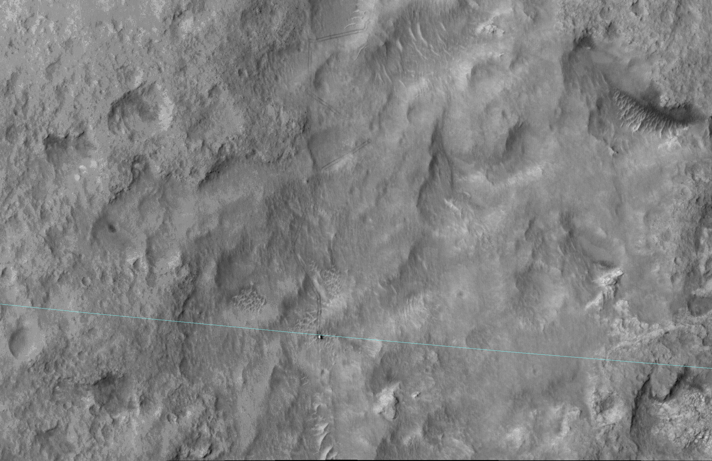
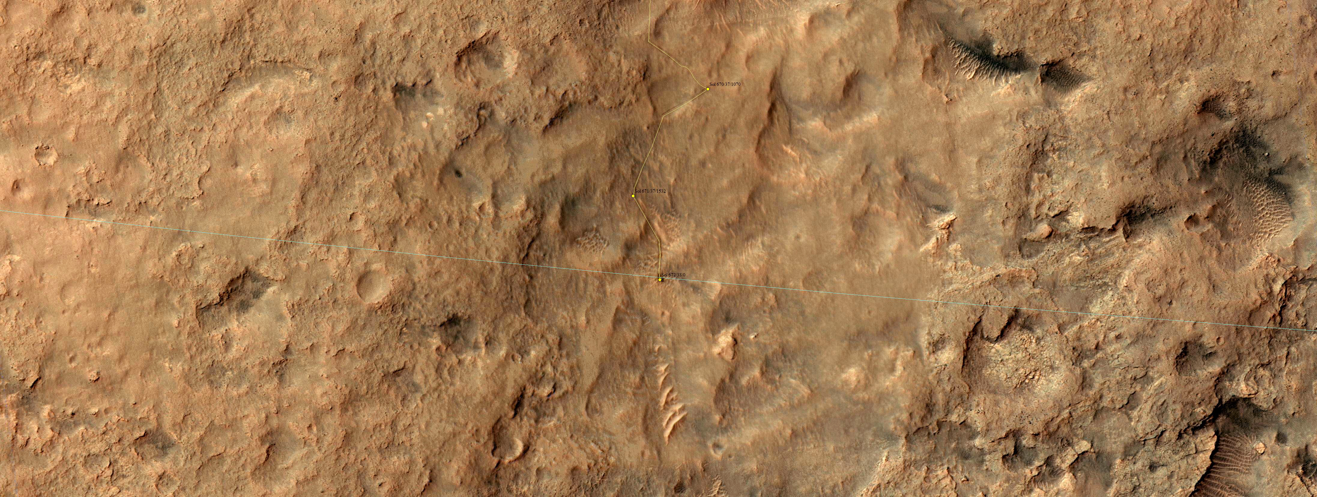
HiRISE captured this image on 27 June 2014, when Curiosity had just crossed the edge of the 3-sigma landing ellipse (see this image; blue line is the edge of the ellipse). OK, I don’t hear any cheering yet...you must be wondering “what the heck is a 3-sigma landing ellipse?”
That’s a statistical prediction of where on Mars the rover might end up landing, given uncertainties such as atmospheric conditions during entry and descent. “3-sigma” means 3 standard deviations, so the rover was very, very likely (to about the 99.9% level) to land somewhere inside this ellipse.
Such 3-sigma ellipses get a lot of scrutiny during landing site selection, because we don’t want anything dangerous like boulders or cliffs inside this ellipse during landing. Thus MSL didn’t try to land right at the base of Mount Sharp where the most interesting terrains lay (as seen from orbit), and spent almost exactly one Mars year roving (and exploring) until arriving at the edge of the ellipse.
Maybe the landing-site aficionados are cheering now? Let’s try this: now that MSL is outside the safe-to-land ellipse, the landscape will get more interesting. The rover can drive around landscape features that would be dangerous to land on. Both the scenery and the geology should be more exciting in the next Mars year. In fact, scrolling to the south in the HiRISE image provides a preview: lots of cliffs and rippled patches of sand.
Here is a colorized version of the crossing of the ellipse.

Dunes cover all but the highest hill of this image. These dunes are part of Olympia Undae, a huge dune field located near the north pole.
Orbit Number: 54773 Latitude: 79.9626 Longitude: 192.456 Instrument: VIS Captured: 2014-04-19 20:12

Pavonis Mons is a giant shield volcano similar to (although larger than) those on the Big Island of Hawaii. These volcanoes are mostly made of stacks of overlapping lava flows. These images and digital terrain model (DTM) show a collapse feature on Pavonis Mons. The walls of this conical pit are steep (about as steep as it is possible to get before loose material rolls downhill). The material that used to be here has drained downward through the opening seen in the center into a subterranean void and formed a debris pile. The top of this debris pile can be seen through the opening about 28 meters (92 feet) further down.
From this DTM we can measure how much material drained out of the conical pit and so estimate how tall the debris pile is. These estimates are enormous: the debris pile itself is at least 62 meters (203 feet) tall. Given that the top of this pile is 28 meters below the rim of the central hole, this tells us that the empty cavity was once 90 meters (295 feet) deep, prior to the collapse and infilling! Only a handful of caves on the Earth reach or exceed this size and they all formed by having liquid water dissolve underground limestone, neither of which are readily available on Mars.
Sometimes the tops of lava flows freeze on the surface even while the lava continues to move underground in a lava tube. If these tubes drain, then lava tube caves can be left behind. Sections of the roof may later collapse, creating roof openings, and these openings can be imaged from orbit. Could this be a view into a lava tube? If so, it would dwarf all lava tubes on the Earth! It's also possible that this collapse is above some more substantial part of the volcano's internal plumbing system and collapses deep with the mountain are allowing voids to open up near the surface. It would no doubt be very exciting for future astronauts to explore this mammoth cave and figure out its origin.
This HiRISE image shows a valley filled with an assortment of linear ridges. These ridges are often referred to as transverse aeolian ridges, or TAR, and they take a variety of forms. Here they sit at right angles to the direction of the valley, because the topography funnels the wind along the trough.
At this location, some of the TAR have secondary structures, likely small ripples. It is common for sand dunes to be covered in small ripples, often with different orientations that may be shaped by winds redirected by the larger dunes. Here the secondary structures have an unusual radiating/converging pattern, giving the TAR here a feathery appearance.

The hills in this VIS image are part of Protonilus Mensae, located on the northern margin of Terra Sabaea.
Orbit Number: 54746 Latitude: 45.7125 Longitude: 53.6208 Instrument: VIS Captured: 2014-04-17 14:35

This image shows a prominently stratified transect through the rock of a mountain of material in the middle of Hebes Chasma.
The knobby material showing several lineations in the center of the scene may be remnants of landslides that exposed these tall, steep slopes in this image and just off-scene to the west. Mid-way up the slope (and to a lesser extent all the way up to the top) a series of alternating lighter and darker bands can be traced running east-west across the ridges and troughs of the outcrop. Just below this, dark material is eroding off of the slope, moving downhill, and collecting in fans at the base of the cliff.
Exposures of layered rock like these are helpful in determining the types of geologic processes that have occurred at an area over time, and the landslide and fan deposits tell of how the region is being eroded more recently, including today.

The linear depressions in this VIS image are called graben. Graben are bounded on both sides by faults, and the central material has shifted downward between the faults. Cyane Fossae are near Alba Mons.
Orbit Number: 54733 Latitude: 28.9208 Longitude: 245.057 Instrument: VIS Captured: 2014-04-16 13:29

This recent observation is the fifth time we’ve imaged this spot on Mars. We often re-image spots on the surface to search for, or track changes, due to active processes, such as migrating sand dunes.
In this case, there isn’t any known activity, although careful comparison of the images could show changes. Instead, we acquired these pictures at a range of viewing and illumination angles as an experiment to try to extract new information at the limits of image resolution. This is possible in two ways: by seeing the 3D shapes from different illumination and viewing angles, and, after orthorectification of the images, by combining them into a “super-resolution” image. (Orthorectification shows how the sloping surface appears from directly overhead).
This location is also the site of an early candidate for location of the Beagle 2 lander based on an image from the Mars Global Surveyor. HiRISE has acquired 24 other images covering most of the expected Beagle-2 landing ellipse, but no clear evidence for Beagle 2 has been reported.

This VIS image very clearly shows the layering that is found in both polar caps. This image is of the north polar cap.
Orbit Number: 54723 Latitude: 79.6439 Longitude: 339.648 Instrument: VIS Captured: 2014-04-15 17:20

This VIS image shows Hyperborei Cavi - the low regions on the right side of the image. Dunes are found both in the lows and on the higher region on the left side of the image. The higher region is part of Hyperborea Lingula.
Orbit Number: 54719 Latitude: 80.2492 Longitude: 310.232 Instrument: VIS Captured: 2014-04-15 09:33

Today's VIS image shows dunes on the margin of Olympia Undae, a large dune field near the north pole.
Orbit Number: 54716 Latitude: 78.7802 Longitude: 182.831 Instrument: VIS Captured: 2014-04-15 03:31