
Today's VIS image shows part of Siton Undae, one of the dune fields near the north polar cap.
Orbit Number: 54482 Latitude: 76.5319 Longitude: 297.509 Instrument: VIS Captured: 2014-03-26 21:27
Photo credit: NASA/JPL-Caltech/Arizona State University
Today's VIS image shows part of Siton Undae, one of the dune fields near the north polar cap.
Orbit Number: 54482 Latitude: 76.5319 Longitude: 297.509 Instrument: VIS Captured: 2014-03-26 21:27

The numerous dust devil tracks in this VIS image are located in Utopia Planitia.
Orbit Number: 54464 Latitude: 54.2732 Longitude: 85.5458 Instrument: VIS Captured: 2014-03-25 10:02

Today's VIS image shows a portion of Olympus Rupes, part of the steep margin surrounding Olympus Mons. The term rupes means scarp.
Orbit Number: 54309 Latitude: 22.1556 Longitude: 228.416 Instrument: VIS Captured: 2014-03-12 16:04

Today's image shows another section of Siton Undae. There is a crater just off the image to the left (west). In the lee of this unnamed crater there are no dunes, but there are numerous dust devil tracks. Dunes surround the crater, except for the lee area. The winds, moving from west to east, are channeled into a chaotic regime by the crater rim, which has created the dune free area and the dust devils.
Orbit Number: 54307 Latitude: 74.3631 Longitude: 300.632 Instrument: VIS Captured: 2014-03-12 11:05

Today's VIS image shows some of the dunes that are located near the north polar cap. This region of dunes is part of Siton Undae.
Orbit Number: 54300 Latitude: 75.5168 Longitude: 300.696 Instrument: VIS Captured: 2014-03-11 21:50

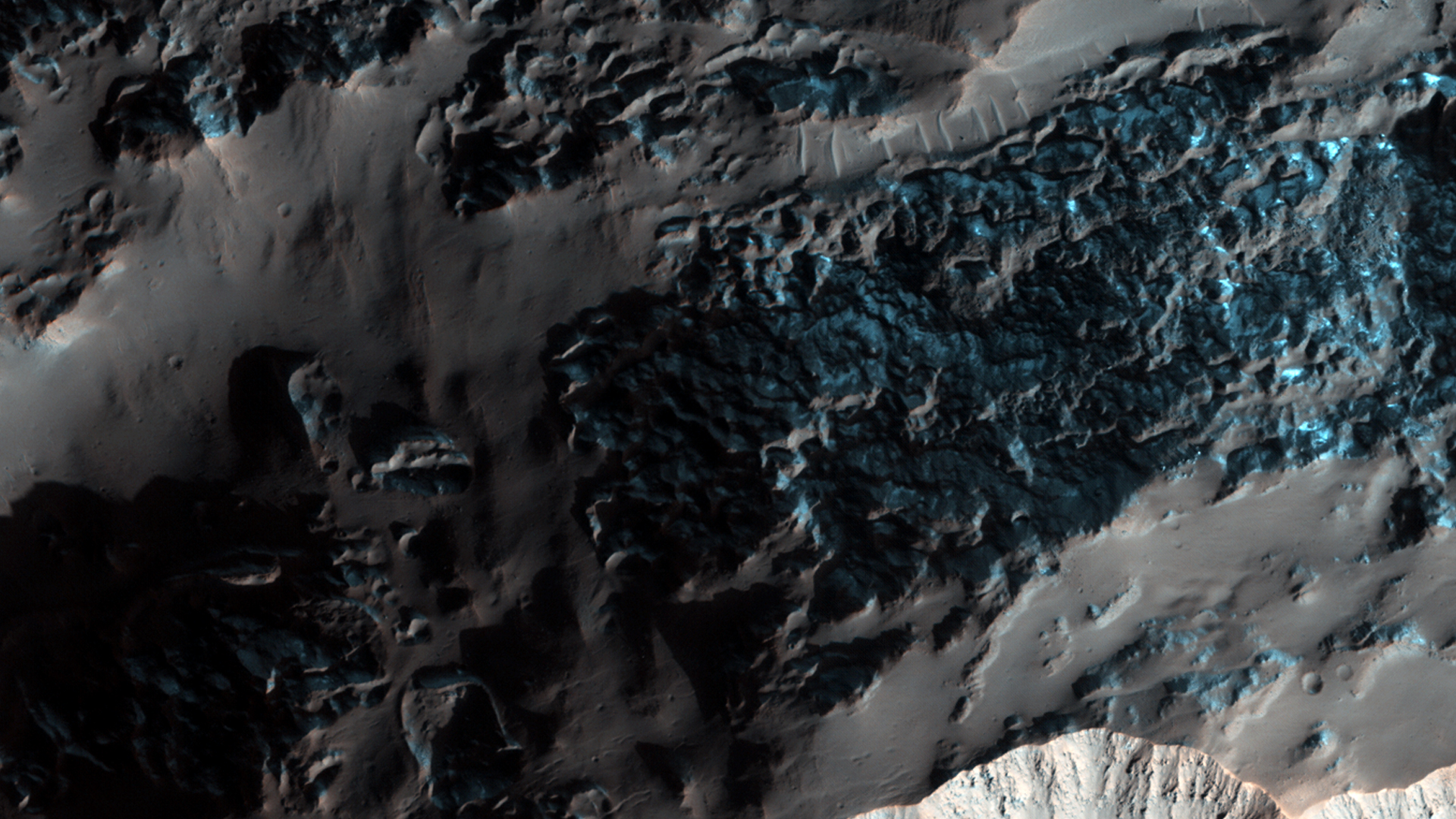
Right past the sharp, but warped rim of this ancient impact crater are deposits of winter frost, which show up as blue in enhanced color.
There are two possible science goals that we can study here: what does the terrain look like during the Martian summer, because HiRISE resolution can track changes over time. And second, could the gullies in this crater be a reasonable place to look for recurring slope lineae (or RSL) to occur? The slopes of certain craters have been home these phenomena in other regions as well.
Note: the images here are not map-projected, so approximate north is dow

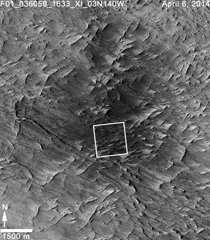
This observation shows an incredible diversity of ancient lava tubes and impact craters filled with sediment on the flank of Arsia Mons.
The rationale for this observation is to get a better look at those lava tubes; their shapes, morphology, and erosional degradation, which ultimately might help to date active period when lava flowed through the volcano. We will also be able to see in high resolution an erosional “snapshot” of the collapsed lava tubes and how they have been modified by dust falling from the air, mass-wasting, and impacts over time.
This is a stereo pair with ESP_030876_1790.

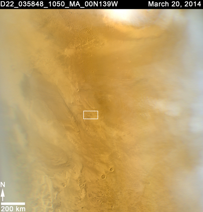
Formative down-slope winds descending on Mars’ North Polar ice cap likely play an important role in transporting sediment from the base of the ice cap into the dune fields that sit beyond the ice cap.
The deep chasm that formed on the polar cap edge is identified as an area of strong down-slope winds and has a clear connection to Mars’ largest dune field, Olympia Undae. Repeat HiRISE images from this chasm that specifically targets the dunes, provides the basis to evaluate the sand fluxes which are associated with the dune and ripple movement in this area.
This is a stereo pair with ESP_036176_2640.

The unnamed channels in this VIS image are located in northern Arabia Terra.
Orbit Number: 54291 Latitude: 38.2988 Longitude: 29.8555 Instrument: VIS Captured: 2014-03-11 04:26

On 20 March 2014, a dark spot on the surface of Mars, about 5 miles (8 kilometers) in diameter was seen for the first time in low-resolution (approximately 1 kilometer) imaging from the Mars Color Imager (MARCI) camera on Mars Reconnaissance Orbiter (MRO). Because MARCI sees essentially the whole planet every day, the sudden appearance of a dark spot was of note.
To follow up, the Context Camera (CTX) obtained a high resolution picture of the area in question in early April. Before and after imaging revealed two new large impact craters within the blast zone. At 6 meters per pixel, CTX can detect the dark blast locations but usually cannot resolve the crater that formed the blast, because most fresh impact craters are only a few meters across.
This is where the high resolution of HiRISE comes in: our camera was able to show the fine surface details within the blast zone. The largest of the new craters, appears slightly asymmetric in shape, and measures 159 x 143 feet (48.5 x 43.5 meters) in diameter, making it the largest new crater detected on Mars by MRO to date. Both HiRISE and CTX images also show numerous, new, small landslides within the blast zone.
All of these coordinated observations also demonstrate how different teams on the same spacecraft can work together to examine interesting features in greater detail.
Note: a newer image of this area, is also available and has an anaglyph.

The dark marks left behind after the passage of a dust devil cover this region of Utopia Planitia.
Orbit Number: 54264 Latitude: 52.6856 Longitude: 91.2059 Instrument: VIS Captured: 2014-03-08 23:00

Regions of mesas and channels are termed chaos. This region on the margin of Terra Sabaea has several areas of chaos.
Orbit Number: 54252 Latitude: 41.0061 Longitude: 74.7617 Instrument: VIS Captured: 2014-03-07 23:02

The complex channel in this VIS image is part of Olympica Fossae, and was most likely formed by the flow of lava. A windstreak in the lee of a small crater near the bottom of the image indicates winds blowing from east to west.
Orbit Number: 54246 Latitude: 24.0578 Longitude: 244.996 Instrument: VIS Captured: 2014-03-07 11:38

This vista of the Endeavour Crater rim was acquired by NASA's Mars Exploration Rover Opportunity from the southern end of "Murray Ridge" on the western rim of the crater. It combines several exposures taken by the rover's panoramic camera (Pancam) on the 3,637th Martian day, or sol, of the mission (April 18, 2014).
The view extends from the east-southeast on the left to southward on the right. It encompasses the far rim of Endeavour Crater on the left and the crater's western rim on the right. Endeavour is 14 miles (22 kilometers) in diameter.
The small impact crater visible in the distance on the slopes of the far rim is about 740 feet (about 225 meters) in diameter and is 13 miles (21 kilometers) away. The high peak in the distance on the right is informally named "Cape Tribulation" and is about 1.2 miles (2 kilometers) to the south of Opportunity's position when this view was recorded. The rim curves off to the left from Cape Tribulation in a series of peaks towards the far southern crater rim.
The floor of Endeavour crater is filled with dark sand, brighter dust, and, in the distance, dusty haze. Outcrops here on the western rim are crater ejecta covered in the foreground by dark sand ripples. On Sol 3662 (May 13, 2014), Opportunity approached the dark outcrops about halfway down on the right side of the image.
The view merges exposures taken through three of the Pancam's color filters, centered on wavelengths of 753 nanometers (near-infrared), 535 nanometers (green) and 432 nanometers (violet). It is presented in approximately true color.

This unnamed channel is located on the northwest margin of Arabia Terra.
Orbit Number: 54230 Latitude: 32.6306 Longitude: 347.534 Instrument: VIS Captured: 2014-03-06 03:05

This artist's concept depicts the stationary NASA Mars lander known by the acronym InSight at work studying the interior of Mars. The InSight mission (for Interior Exploration using Seismic Investigations, Geodesy and Heat Transport) is scheduled to launch in March 2016 and land on Mars six months later. It will investigate processes that formed and shaped Mars and will help scientists better understand the evolution of our inner solar system's rocky planets, including Earth.
InSight will deploy two instruments to the ground using a robotic arm: a seismometer (contributed by the French space agency Centre National d'Etudes Spatiales, or CNES) to measure the microscopic ground motions from distant marsquakes, providing detailed information about the interior structure of Mars; and a heat-flow probe (contributed by the German Aerospace Center, or DLR) designed to hammer itself 3 to 5 meters (about 16 feet) deep and monitor heat coming from the planet's interior. The mission will also track the lander's radio to measure wobbles in the planet's rotation that relate to the size of its core and will include a camera and a suite of environmental sensors to monitor the weather and variations in the magnetic field. Lockheed Martin Space Systems, Denver, is building the spacecraft.
The following are shown in the annotated image:
• Grapple – Mechanism at the end of the IDA that grips the instruments during deployment
• Heat Flow Probe – Hammering mechanism that pulls the temperature sensors down into the regolith
• HP3 – Heat Flow and Physical Properties Package, the heat flow experiment
• IDC – Instrument Deployment Camera, pointable medium-resolution camera
• IDA – Instrument Deployment Arm
• ICC – Instrument Context Camera, fixed wide-angle camera
• Pressure Inlet – Wind-shielded opening for pressure sensor
• RISE Antenna – X-band radio antenna for the Rotation and Interior Structure Experiment
• SEIS – Seismic Experiment for Interior Structure, the seismometer
• Tethers – Cables carrying electrical power, commands and data between the lander and instruments
• TWINS – Temperature and Winds for InSight, environmental sensors
• UHF Antenna – Antenna used for communication with orbital relay spacecraft
• WTS – Wind and Thermal Shield protecting the seismometer from the environment

This view from the Mars Hand Lens Imager (MAHLI) on NASA's Curiosity Mars Rover shows the rock target "Windjana" and its immediate surroundings after inspection of the site by the rover. The drilling of a test hole and a sample collection hole produced the mounds of drill cuttings that are less red than the other visible surfaces. This is material that the drill pulled up from the interior of the rock.
This view is from the 627th Martian day, or sol, of Curiosity's work on Mars (May 12, 2004).
The open hole from sample collection is 0.63 inch (1.6 centimeters) in diameter. It was drilled on Sol 621 (May 5, 2014). A preparatory "mini drill" hole, to lower right from the open hole, was drilled on Sol 615 (April 29, 2014) and subsequently filled in with cuttings from the sample collection drilling.
Two small patches of less-red color to the right of the drill holes are targets "Stephen" (higher) and "Neil," where multiple laser hits by Curiosity's Chemistry and Camera (ChemCam) instrument blasted some of the reddish surface dust off the surface of the rock.
The vigorous activity of penetrating the rock with the rover's hammering drill also resulted in slides of loose material near the rock. For comparison to the site before the drilling, see the Sol 609 image of Windjana at http://photojournal.jpl.nasa.gov/catalog/PIA18087.

Today's VIS image shows another unnamed crater near the north pole with dunes on its floor.
Orbit Number: 54223 Latitude: 73.4676 Longitude: 2.52812 Instrument: VIS Captured: 2014-03-05 13:45

Rabe Crater is a 108 km-wide impact crater with an intricately shaped dune field. The dune material likely comprises locally eroded sediments that have been shaped by prevailing winds. Other smaller craters in the region also contain these dark deposits. One relatively young and deep crater can be seen in the upper left; as well as the dark material, channels and grooves are clearly visible in its crater walls.
The images used for this mosaic were taken by the High Resolution Stereo Camera on ESA’s Mars Express on 7 December 2005 (orbit 2441) and 9 January 2014 (orbit 12736). The scene is located at 35°E/44°S, about 320 km west of the giant Hellas impact basin in the southern highlands of Mars. The image resolution is about 15 m per pixel.

Numerous unnamed channels are located on the eastern margin of Tempe Terra.
Orbit Number: 54219 Latitude: 35.3128 Longitude: 305.122 Instrument: VIS Captured: 2014-03-05 06:14

Rabe Crater is a 108 km-wide impact crater with an intricately shaped dune field. The dune material likely comprises locally eroded sediments that have been shaped by prevailing winds. Other smaller craters in the region also contain these dark deposits. One relatively young and deep crater can be seen in the upper left; as well as the dark material, channels and grooves are clearly visible in its crater walls.
The images used for this mosaic were taken by the High Resolution Stereo Camera on ESA’s Mars Express on 7 December 2005 (orbit 2441) and 9 January 2014 (orbit 12736). The scene is located at 35°E/44°S, about 320 km west of the giant Hellas impact basin in the southern highlands of Mars. The image resolution is about 15 m per pixel.

A sand sheet with surface dune forms partly surrounds the central peak of this unnamed crater near the north pole.
Orbit Number: 54218 Latitude: 71.9875 Longitude: 344.52 Instrument: VIS Captured: 2014-03-05 04:03

A sand sheet with surface dune forms covers the floor of this unnamed crater near the north pole.
Orbit Number: 54212 Latitude: 74.1474 Longitude: 319.12 Instrument: VIS Captured: 2014-03-04 16:01

Dark slope streaks mark many of the hills in this VIS image. This region of hills is called Tartarus Colles. The term colles means small hills or knobs.
Orbit Number: 54211 Latitude: 14.6763 Longitude: 172.669 Instrument: VIS Captured: 2014-03-04 14:33

Even though it may only be a lump of porous rock, Phobos isn’t shy about hogging the limelight in this sequence taken by ESA’s Mars Express. These three images show Phobos, the larger of the two Martian moons, darting across the frame in front of Jupiter, visible as the pale dot in the center. From right to left, the frames show snapshots before, during and after the small moon’s journey in front of the gas giant.
Observed on 1 June 2011, this unusual alignment is known as a conjunction, and occurs when two Solar System bodies appear to pass close to one another on the sky. This is an optical illusion caused by our perspective–when these pictures were taken there was a distance of almost 11,400 km between the spacecraft and Phobos, and a further 529 million km to Jupiter.
These three frames are part of a set of 104 taken over a period of 68 seconds by the high-resolution stereo camera on Mars Express. Some of the images were also processed to form a video. The images and the video were originally released in June 2011.

This VIS image shows the layering of the ice at the north pole.
Orbit Number: 54206 Latitude: 79.8759 Longitude: 339.493 Instrument: VIS Captured: 2014-03-04 04:19

Today's VIS image shows part of Aspledon Undae, one of several dune fields near the north pole. The term Undae means dunes.
Orbit Number: 54150 Latitude: 72.4562 Longitude: 307.913 Instrument: VIS Captured: 2014-02-27 13:33

Today's VIS image shows a portion of Lycus Sulci, a complex region of ridges located on the northern side of Olympus Mons. The term sulci means subparallel furrows and ridges.
Orbit Number: 54147 Latitude: 31.6354 Longitude: 220.399 Instrument: VIS Captured: 2014-02-27 08:03

The large graben in this VIS image is part of a series of graben located on the southern flank of Alba Mons. This collection of graben is called Ceraunius Fossae. The term fossae means long, linear depressions.
Orbit Number: 54146 Latitude: 35.0747 Longitude: 249.803 Instrument: VIS Captured: 2014-02-27 06:03

This image from the Navigation Camera (Navcam) on NASA's Curiosity Mars rover shows two holes at top center drilled into a sandstone target called "Windjana." The farther hole, with larger pile of tailings around it, is a full-depth sampling hole. It was created by the rover's hammering drill while the drill collected rock-powder sample material from the interior of the rock. The nearer hole was created by a shallower test drilling into the rock in preparation for the sample collection. Each hole is 0.63 inch (1.6 centimeters) in diameter. The full-depth hole is about 2.6 inches (6.5 centimeters) deep, drilled during the 621st Martian day, or sol, of Curiosity's work on Mars (May 5, 2014). The test hole is about 0.8 inch (2 centimeters) deep, drilled on Sol 615 (April 29, 2014). This image was taken on Sol 621 (May 5).
The sandstone target's informal name comes from Windjana Gorge in Western Australia. The rock is within a waypoint location called "The Kimberley," where sandstone outcrops with differing resistance to wind erosion result in a stair-step pattern of layers. Windjana is within what the team calls the area's "middle unit," because it is intermediate between rocks that form buttes in the area and lower-lying rocks that show a pattern of striations.

Today's VIS image shows some of the lava flows located east of the large Tharsis volcanoes.
Orbit Number: 54145 Latitude: 17.9142 Longitude: 275.981 Instrument: VIS Captured: 2014-02-27 04:11

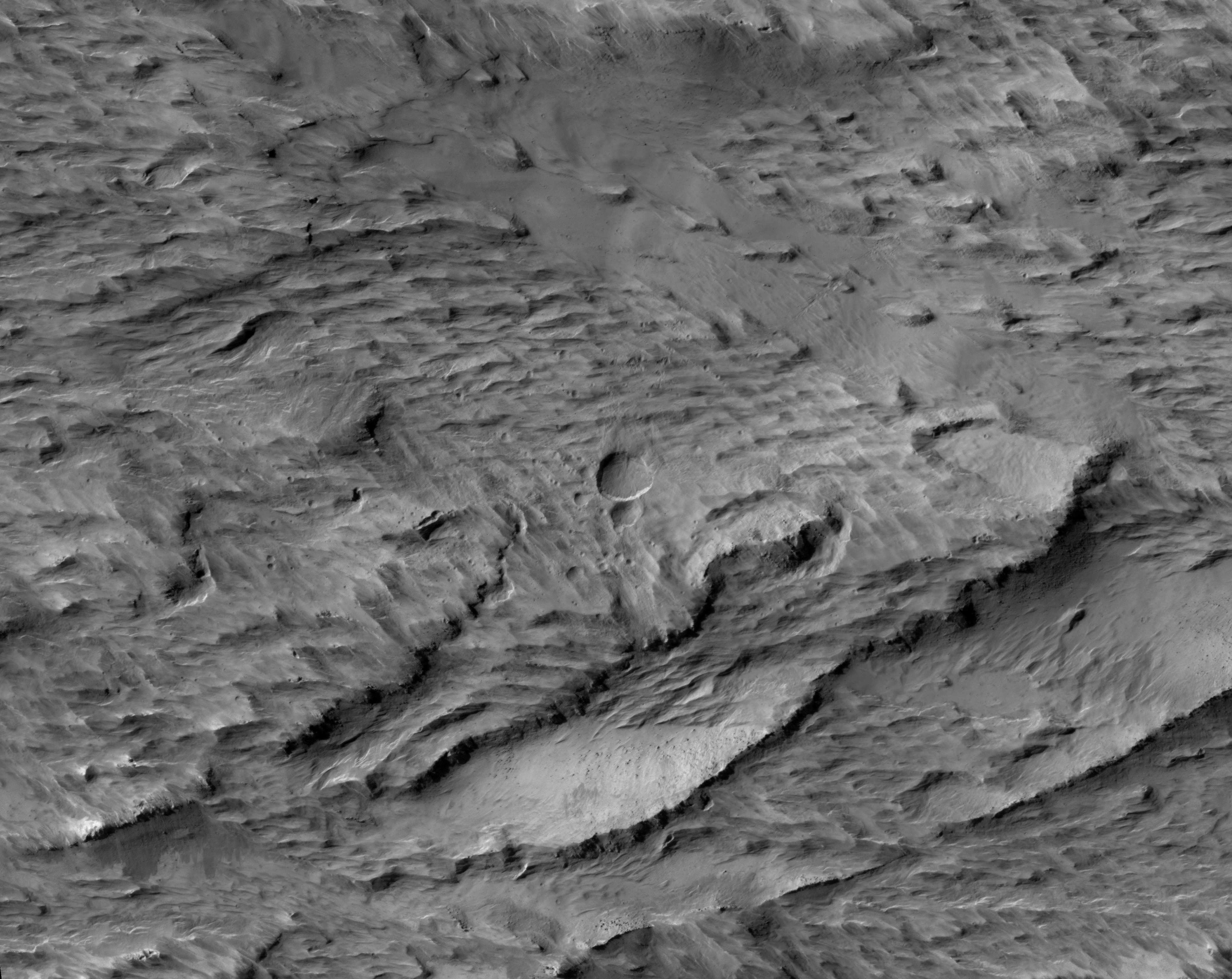
The purpose of this observation is to determine how these formations, called “yardangs” are forming within a layer of bedrock.
Yardangs are streamlined hills that are carved by wind erosion from bedrock. The rock must be sufficiently erodible for wind to either deflate (pick up) poorly-consolidated pieces or scrape the surface by blowing sand. HiRISE resolution allows us to view yardangs and the component layers more closely, and to get a better understanding of the material.
“Yardang” is a word of Turkish origin, meaning “steep bank.“ When viewed from above, yardangs can look like the hull of a boat.

Nili Patera is one of the most active dune fields on Mars. As such, it is continuously monitored with HiRISE, with a new image acquired about every six weeks.
By monitoring the sand dune changes, we can determine how winds vary seasonally and year-to-year. This observation is one of the more recent Nili images (1 March 2014). Compared to an image acquired on 22 November 2012, changes are obvious. The ripples on the dunes have moved, as well some of the dune boundaries, such as the one at upper left. New landslides on the central dune”s lee face are apparent.
Such changes, in just 16 months (and finer scale changes have been seen in just a couple of weeks), demonstrate the effectiveness of wind in modifying the Martian landscape.

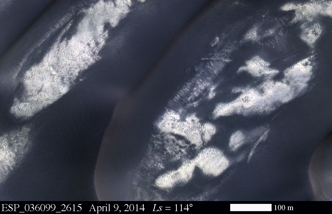
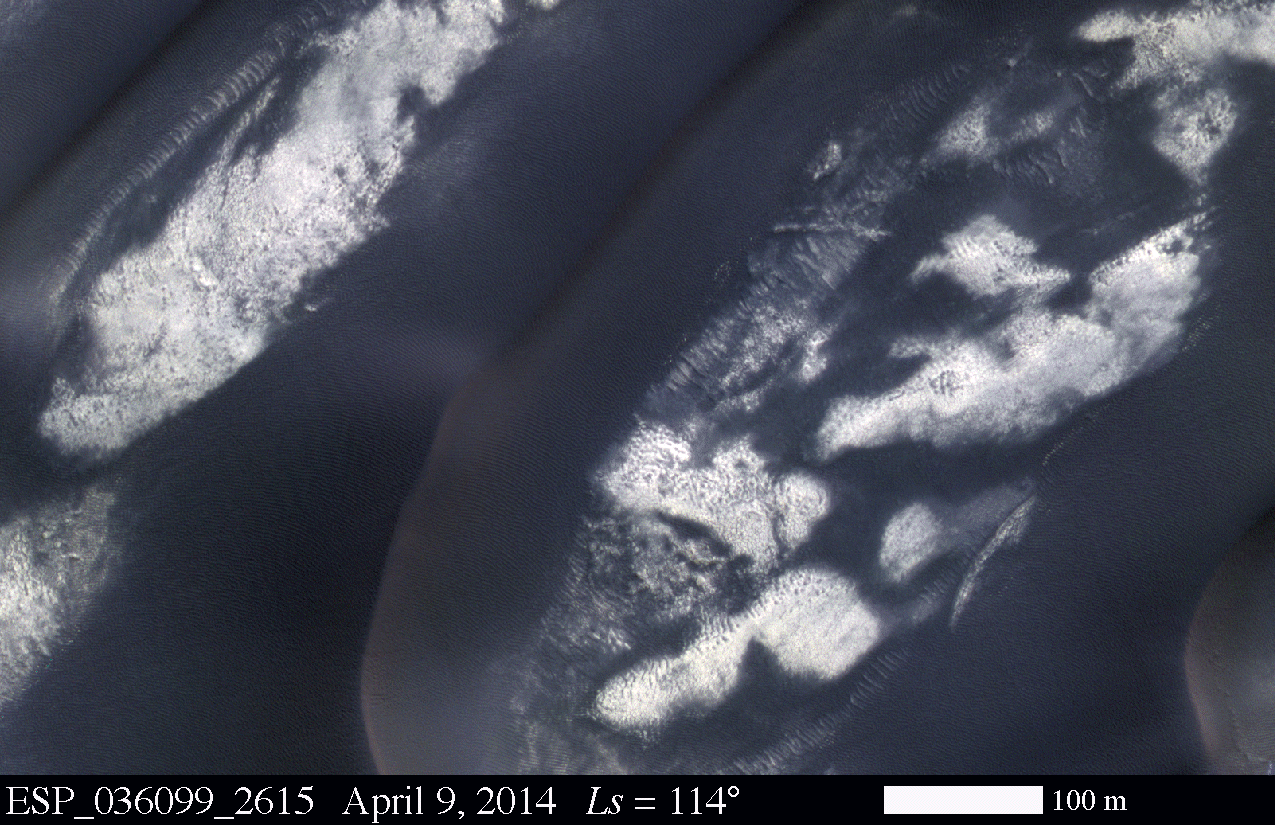
As the season changes from spring to summer, the dunes surrounding the north polar cap become darker and darker.
Orbit Number: 54141 Latitude: 79.7727 Longitude: 198.79 Instrument: VIS Captured: 2014-02-26 19:49

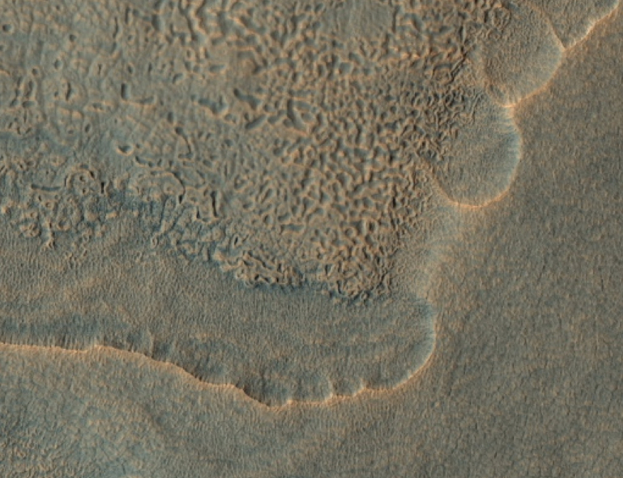
Olympia Undae is a large field of sand dunes surrounding Mars’ North Polar ice cap. Because of the high latitude of the dunes, they are covered with water and carbon dioxide frost in the winter and are poorly illuminated. They are best viewed in the summer, when features such as ripples on the dunes’ surface can be seen in detail. (Some dunes are probably also covered over by the cap, but we can’t see them directly.)
In this image, we see the dunes in early summer of this year. The dark material is sand that makes up the dunes. Between the dunes, bright bedrock and some lingering patches of frost that have not yet sublimated are visible. Zooming in, we can see small ripples on the dunes’ surface, as well as the bright inter-dune areas. This area has been viewed several times by HiRISE, so we can compare this image to past ones to see if there have been changes.
Here, we compare the new view to one from approximately a Mars years ago (about 2 Earth years), but slightly later in the summer. The most obvious difference between the images is simply the illumination, with the better lighting in the 2012 image showing finer details. Despite these differences, changes in the boundaries of sand and ripple positions are obvious. This shows that winds, perhaps assisted by the sublimation of frost that may loosen sand, are modifying Olympia Undae year-to-year.

The lava flows in today's image are located east of Olympus Mons.
Orbit Number: 54134 Latitude: 21.153 Longitude: 233.622 Instrument: VIS Captured: 2014-02-26 06:26

The objective of this observation was to examine the edge of impact ejecta from a crater to the north-west of this area (north is up, west is to the left). The ejecta visible in the top left of this image seems to be lower than the surrounding surface.
This is unusual because impact ejecta is laid down on top of existing ground. The ejecta also seems to have pits. Perhaps the hot ejecta fell on frozen ground and melted the underlying ice?

Triangular shaped deposits at cliff edges are termed alluvial fans. Alluvial fans typically form in arid regions were water flow is limited, so deposits of material are not washed away. Formation of these alluvial fans in the channel of Kasei Valles likely happened after any flow of fluid in the Valles system.
Orbit Number: 54132 Latitude: 23.0851 Longitude: 291.525 Instrument: VIS Captured: 2014-02-26 02:28