Tuesday, January 31, 2012

Opportunity's Three-Year Trek Across Mars


During the three-year trek of NASA's Mars Rover Opportunity from Victoria crater to Endeavour crater, rover planners captured a horizon photograph at the end of each drive. 309 images taken during the 13-mile journey appear in this video.

Video credit: NASA/JPL-Caltech/Cornell/Arizona State University

Monday, January 30, 2012

Dunes in Noachis Terra


This enhanced-color image shows sand dunes trapped in an impact crater in Noachis Terra, Mars. Dunes and sand ripples of various shapes and sizes display the natural beauty created by physical processes. The area covered in the image is about six-tenths of a mile (1 kilometer) across.

Sand dunes are among the most widespread wind-formed features on Mars. Their distribution and shapes are affected by changes in wind direction and wind strength. Patterns of dune erosion and deposition provide insight into the sedimentary history of the surrounding terrain.

The image is one product from an observation by the High Resolution Imaging Science Experiment (HiRISE) camera taken on November 29, 2011, at 42 degrees south latitude, 42 degrees east longitude. Other image products from the same observation are at http://www.uahirise.org/ESP_025042_1375.

Photo credit: NASA/JPL-Caltech/University of Arizona

Note: This caption is very similar to that of the recent post, Sand Dunes in Noachis Terra. Although the pictures are different, I wouldn't be surprised if both images come from the same crater.

Sunday, January 29, 2012

Double Layer Ejecta in an Arabia Region Crater


When impact craters form, they are generally surrounded by "ejecta": material that is thrown out from the crater by the impact and that settles onto the surrounding terrain. Sometimes there are multiple phases of material that fall to the ground (although both result from the same impact), creating the appearance of layered-ejecta.

This DLE [double layer ejecta] crater formed at the edge of an older/pre-existing crater, the rim of which deflected some of its ejecta. As it deflected the two phases of falling ejecta differently, we can use it to study how ejecta is transported and deposited. With HiRISE resolution, it may be possible for us to determine topography of the rim and then to see how high the barrier was that deflected some of the ejecta flow.

This is also an unusual crater because it is outside the Northern Plains and is relatively young.

This is a stereo pair with ESP_017356_2175.

Photo credit: NASA/JPL/University of Arizona

Notes: This crater is located along the "shore" between Arabia Terra and Chryse Planitia. The closest named feature is Cydonia Mensae to the west. Also, Note: For an mp4 video clip on this impact crater, including additional photographs, click here.

Saturday, January 28, 2012

Fluvial Fan on a Crater Floor


This observation shows a terrific fan-shaped deposit, beginning where the channel enters a crater. This is suggestive of a delta: a deposit that forms when water in a channel flows into a larger area (such as an ocean or a lake). As the water spreads out, it moves slower and drops the sediment that it is carrying, forming the delta. (E.g., a famous Earth example is the Nile River delta.)

The THEMIS instrument also photographed this area (I03235002), as well as the Context Camera (CTX) aboard the Mars Reconnaissance Orbiter. The resolution of HiRISE helps scientists determine the topography of the region which is needed for establishing the stratigraphic relations and flow direction of the area.

Here is a view of the terrain to the south of the craters in the full image.

Photo credit: NASA/JPL/University of Arizona

Notes: This crater is located in Tempe Terra to the west of Chryse Planitia and to the north of Kasei Valles. The closest named crater is Sytinskaya. Also, for an mp4 video clip about this crater, including additional photographs, click here.

Friday, January 27, 2012

Greeley Haven in False Color on Opportunity's Eighth Anniversary


This mosaic of images taken in mid-January 2012 shows the windswept vista northward (left) to northeastward (right) from the location where NASA's Mars Exploration Rover Opportunity is spending its fifth Martian winter, an outcrop informally named "Greeley Haven."

Opportunity's Panoramic Camera (Pancam) took the component images as part of full-circle view being assembled from Greeley Haven.

The view includes sand ripples and other wind-sculpted features in the foreground and mid-field. The northern edge of the the "Cape York" segment of the rim of Endeavour Crater forms an arc across the upper half of the scene.

Opportunity landed on Mars on January 25, 2004, Universal Time and EST (January 24, PST). It has driven 21.4 miles (34.4 kilometers) as of its eighth anniversary on the planet. In late 2011, the rover team drove Opportunity up onto Greeley Haven to take advantage of the outcrop's Sun-facing slope to boost output from the rover's dusty solar panels during the Martian winter.

Research activities while at Greeley Haven include a radio-science investigation of the interior of Mars, inspections of mineral compositions and textures on the outcrop, and monitoring of wind-caused changes on scales from dunes to individual soil particles.

The image combines exposures taken through Pancam filters centered on wavelengths of 753 nanometers (near infrared), 535 nanometers (green) and 432 nanometers (violet). The view is presented in false color to make some differences between materials easier to see.

Photo credit: NASA/JPL-Caltech/Cornell/Arizona State University

Note: For a true-color image of the same view, see PIA15281: Opportunity's Eighth Anniversary View From 'Greeley Haven'.

Thursday, January 26, 2012

Sand Dunes in Noachis Terra


Sand dunes are among the most widespread aeolian (wind-formed) features present on Mars. Their spatial distribution and morphology are affected by changes in wind direction and wind strength. Patterns of dune erosion and deposition provide insight into the sedimentary history of the surrounding terrain.

This image shows sand dunes trapped in an impact crater in Noachis Terra. Dunes and sand ripples of various shapes and sizes, such as in this enhanced-color subimage, show the natural beauty created by physical processes.

This is a stereo pair with ESP_024976_1375.

Photo credit: NASA/JPL/University of Arizona

Notes: This crater is located a very short distance due west of Hellespontus Montes, which is to the west of Hellas Planitia. Also, for an mp4 video clip of these dunes, with additional photographs, click here.

Monday, January 23, 2012

Many Fantastically Colorful Gullies in a Fresh Impact Crater


This image covers a "fresh-looking" impact crater with a diameter of about 2 kilometers (1.2 miles).

There are gullies all around the steep inner slopes of this crater (you can even see them in the shadow by enhancing the brightness of this region), at 35 degrees South latitude. Many craters at this latitude in the southern hemisphere only have gullies on the south-facing slopes, which are shadowed in the wintertime. But this is an especially pristine crater so the slopes may be particularly steep and unstable.


The enhanced color sub image
shows that gullies and their deposits have many different colors. This is due to diverse rock types exposed by the crater and the fact that the gullies have been recently active, so colors have not been homogenized by overlying regolith (soil) or windblown deposits. HiRISE will monitor this site in the future to see if the gullies are currently active.

How long ago did this crater form? It appears nearly pristine, preserving meter-scale morphologies in the ejecta, and there are almost no superimposed (younger) impact craters, so it is probably less than a million years old. That means the crater formed in the most recent 0.02 percent of Mars' existence. The ejecta includes a "herringbone" texture with V-shaped features pointing to the source crater.

Photo credit: NASA/JPL/University of Arizona

Note: This small crater is located in Bosporos Planum, just northeast of Aki Crater. Also, for an mp4 video clip of this impact crater, including additional information and photographs, click here.

Sunday, January 22, 2012

Gullies in Bamberg Crater


This cluster of gullies is on the wall of Bamberg Crater.

The impact crater has an extremely eroded and terraced rim. However, the gullies do not have extensive aprons and overall there appears to be very little material accumulated on the crater floor -- unlike many other craters with gullies. This may indicate the gullies are young features.

However, gully formation on Mars is still not completely understood, and more information and observations are needed to improve our interpretation of these features.

Photo credit: NASA/JPL/University of Arizona

Note: For an mp4 video clip of the gullies of Bamberg Crater, including additional information and photographs, click here.

Saturday, January 21, 2012

Tongue-Shaped Flow Below a Scarp in Phlegra Montes


This observation shows a tongue-shaped flow of material below a scarp in Phlegra Montes, a range of curving mountains and ridges on Mars.

This type of feature is sometimes formed by a debris flow, a landslide, or the flow of ice-rich material. However, the source of the material and how it was deposited here remains unclear.

Photo credit: NASA/JPL/University of Arizona

Note: For an mp4 video clip discussing the above-mentioned area, click here.

Friday, January 20, 2012

The Floor of Beer Crater


This crater was named after German astronomer Wilhelm Beer. It is an ancient crater more than 100 kilometers across, located south of Meridiani Planum.

A full-resolution color sample shows fractured bedrock with dark sand filling low areas. The circular rocky features are probably eroded impact craters and the thin linear features are windblown deposits.

The aeolian (wind) erosion and modification of this ancient surface make it difficult to deduce how the rocks were initially emplaced, but the channeled rims suggest that these could be alluvial fans: deposits carried by flowing water (probably not beer).

Photo credit: NASA/JPL/University of Arizona

Note: For an mp4 video clip discussing the floor of Beer Crater, click here.

Monday, January 16, 2012

Search for Beagle 2 Lander


This is the twelfth image from HiRISE in the part of Isidis basin where the British Beagle 2 spacecraft was supposed to land around Christmas time of 2003.

All contact was lost after its separation from the Mars Express spacecraft six days before atmospheric entry. The lack of telemetry on its way to the surface means there is little information about where the spacecraft may have landed on the surface--we can only search in the region where it was expected to land if the entry, descent, and landing (EDL) sequence had been nominal. EDL was probably not nominal, but perhaps the spacecraft did land correctly and failure occurred for some other reason.

Nothing resembling the Beagle lander has been seen in any of the HiRISE images, although we aren't sure that they've been thoroughly searched. For an idea of what the Beagle 2 hardware might look like, see this web page.

The easiest thing to spot would be the bright parachute, if it actually deployed. The parachutes are still easy to spot at the MER and Pathfinder landing sites, so dust deposition over the past eight years probably would not disguise the bright feature over equatorial regions of Mars. At high latitudes the brightness patterns are reset each winter by the seasonal deposits of carbon-dioxide and dust, as seen at the Phoenix landing site. However, beware of bright cosmic-ray hits.

EDL on Mars is difficult! Only the United States has succeeded, with Viking 1, Viking 2, Mars Pathfinder, Spirit, Opportunity, and Phoenix. The 1999 Mars Polar Lander was a failure, as was Beagle 2 and six landing attempts by the former Soviet Union. One of the Soviet landers, Mars 3, made it to the surface and transmitted some data or noise for 20 seconds before failure. We haven't been able to locate any of the Soviet lander hardware from HiRISE images.

Searching for this hardware is like looking for a needle in a really big haystack, and we don't know what the needle looks like. In August 2012 NASA will attempt to land the biggest rover ever sent to Mars, MSL or Curiosity. HiRISE will attempt to image MSL during descent, as it did for Phoenix, and after what is hopefully a successful landing.

Photo credit: NASA/JPL/University of Arizona

Sunday, January 15, 2012

Banded Wall Outcrop in Ius Chasma


This area was covered in a well-known MOC image of October 1997 (AB1-01303) that shows what appears to be layered rock, deep below the Martian surface.

At the time, this was considered to be revolutionary and seemed to contradict the general view of the upper crust of Mars as being a lunar-like "megaregolith." Later coverage of this outcrop area by MOC is not particularly good and the CTX (Context Camera) coverage doesn't improve on spatial resolution much.

However, experience with other HiRISE images suggests the "layering" will be less obvious at sub-meter-per-pixel scales, but nonetheless we'll see some interesting things. This was thought to be an important area for the development of some post-Viking views of Mars. This underscores how much technology has changed since the 1970s.

Photo credit: NASA/JPL/University of Arizona

Saturday, January 14, 2012

Aram Chaos


The southern cap rock in Aram Chaos is situated in the Martian equatorial region, to the east of the Tharsis region.

In Ancient Greek, "chaos" meant an emptiness or void, the gap that existed between the heavens and the earth; here, we use the word to describe terrain that is jumbled and "confused." As the image shows us, Aram Chaos is actually a heavily eroded impact crater, with material on the floor that is blocky in contrast to some of the surrounding terrain.

This would be an interesting area to explore and to send a rover, because we think that water might have existed in the underground as ice.

Photo credit: NASA/JPL/University of Arizona

Friday, January 13, 2012

Defrosting Barchan Dunes


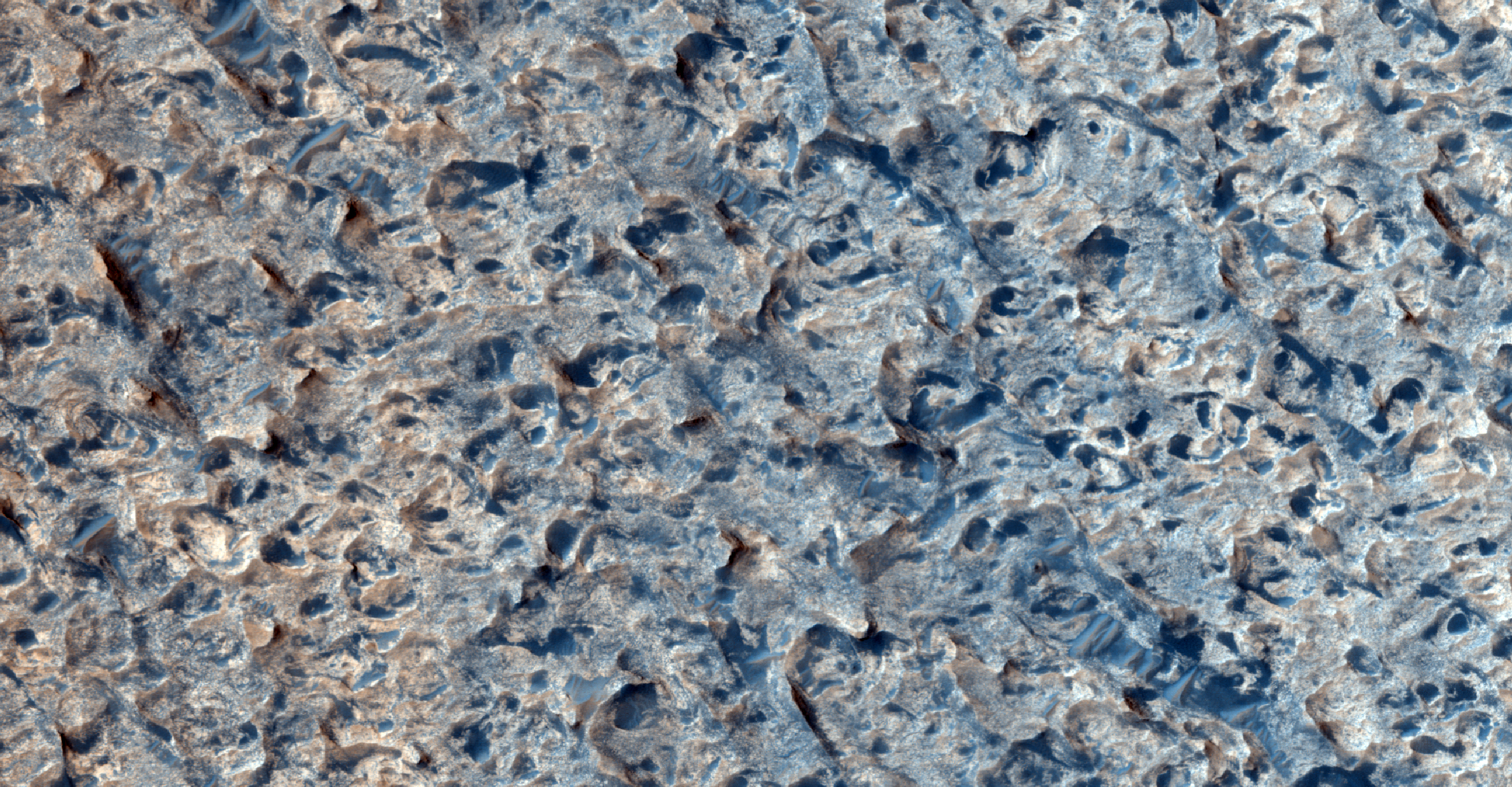
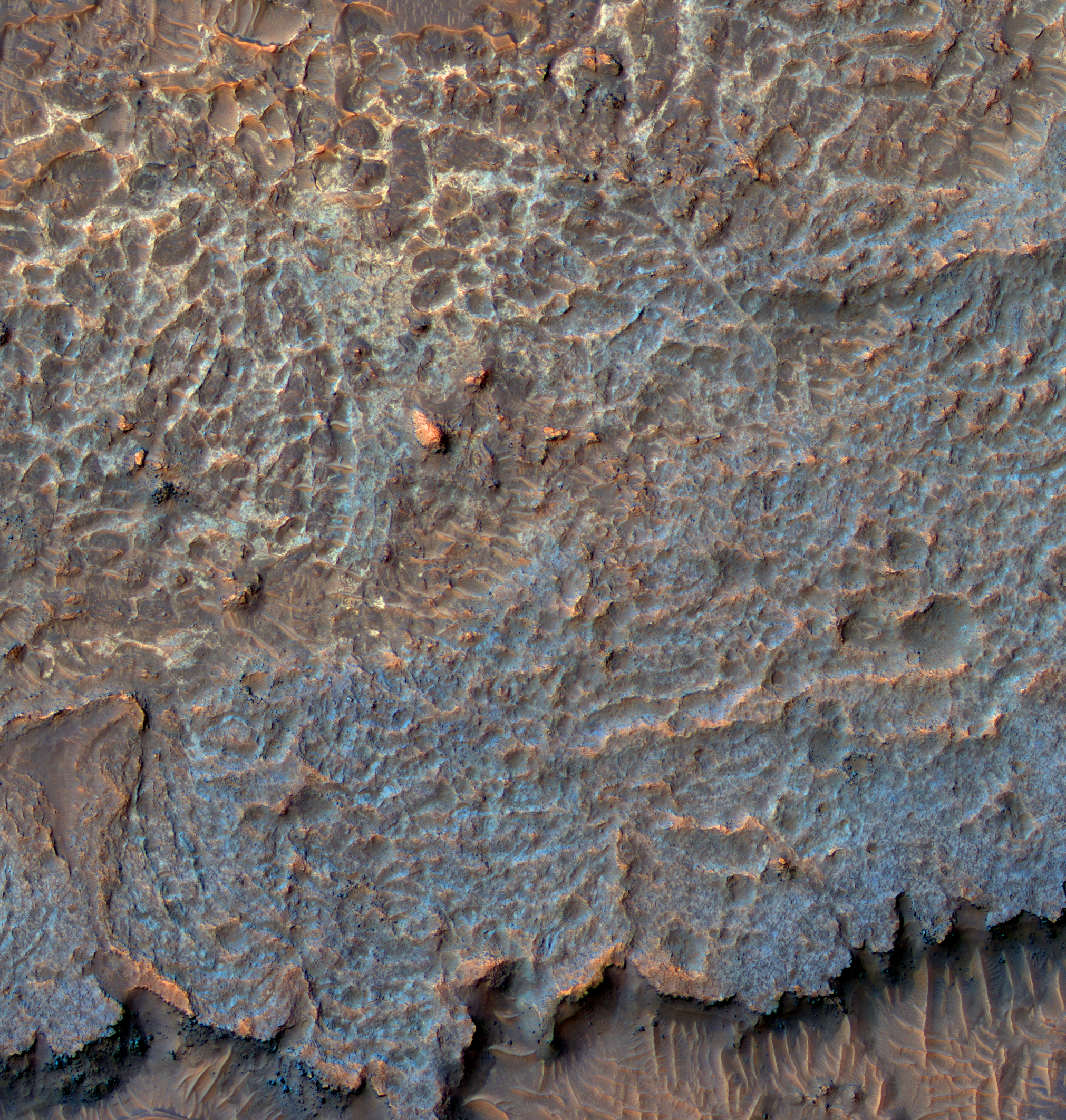
This HiRISE image shows sand dunes near the eastern part of North Polar erg.

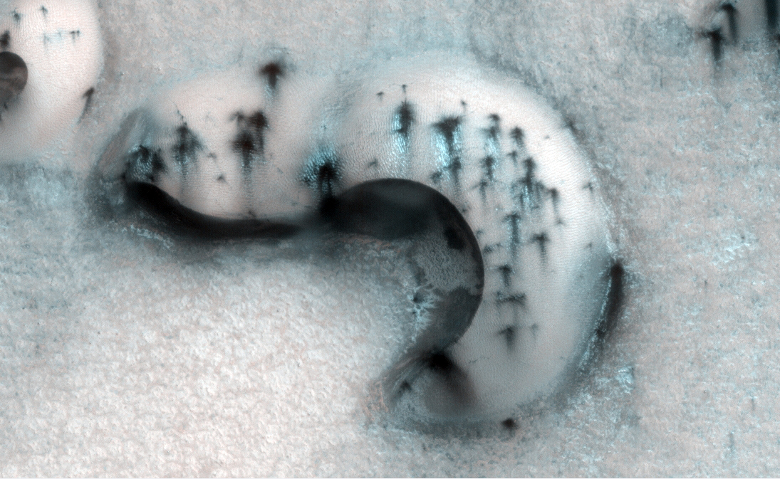
The dunes imaged here are similar to barchan dunes, commonly found in desert regions on Earth. Barchan dunes are generally crescent-shaped with a steep slip face bordered by horns oriented in the downwind direction. Barchan dunes form by winds blowing mainly in one direction and thus are good indicators of the dominant wind direction when the dunes formed.

The dunes and surrounding surface appear bright because they are covered with seasonal frost left over from the northern hemisphere winter. Sunlight is now falling on the North Polar region, and carbon dioxide frost that accumulated during winter is sublimating (going directly from solid to gas) and the surface beneath the frost is being revealed.

Composed primarily of basaltic sand, the dunes will appear dark during the northern hemisphere summer. The dark spots are areas where some of this frost has begun to sublime away, and/or where wind has exposed the underlying dark sand.

Photo credit: NASA/JPL/University of Arizona

Note: This image is located west of Olympia Mensae, and north of Louth Crater. I am not quite sure what "north polar erg" the author is referring to in the first sentence. The eastern end of the primary north polar erg, Olympia Undae, is actually on the other side of the planet. This location is much closer to the western end of Olympia Undae, although that is still some distance away. Personally, I would say that the image location is in Vastitas Borealis.

Wednesday, January 11, 2012

Floral-Shaped Volcano on Cerberus Fossae


This is a small volcano superposed on the flanks of a larger one of the Cerberus Tholi.

This smaller feature has a single vent, aligned along a Cerberus Fossae trough, and it has flows radiating away from this vent in all directions, somewhat looking like a flower.

These flows appear somewhat darker than their surroundings, though this might be owing to roughness as much as to relative youth. Note that even at Context Camera (CTX) scale, we can see that there are some small impact craters superimposed on this feature, indicating that it is not entirely young.

This is a stereo pair with ESP_023811_1880.

Photo credit: NASA/JPL/University of Arizona

Note: Cerberus Tholi is a group of seven volcanic hills located in Elysium Planitia. Cerberus Tholi is located south of the eastern end of Cerberus Fossae, and roughly encircle Tombaugh Crater.

Tuesday, January 10, 2012

Transverse Aeolian Ridges in Proctor Crater


Transverse Aeolian Ridges (or TARs) are small aeolian bedforms that are distinct from typical dunes or ripples. TARs are found all over Mars, and are typically located near layered terrains, or near fields of large dark dunes as they are here in Proctor Crater in the southern hemisphere.

TARS form transverse (perpendicular) to the wind direction and are thought to be composed of coarse-grained material. They also appear to be indurated (hardened) and may be much less mobile than the larger dunes.

This is a stereo pair with ESP_024515_1320.

Photo credit: NASA/JPL/University of Arizona

Monday, January 9, 2012

Lava Flow Oozing into a Crater


This image captures a fairly rare situation. In general, as lava flows along, it fills in low points and holes it encounters in its path and flows around high points such as hills and ridges. In this image there are two lava flows interacting with an impact crater.

Although an impact crater approximately 3 kilometers (1.8 miles) wide such as this is a deep hole in the ground (likely a couple hundred meters or several hundred feet deep), it is surrounded by a rim crest that is actually higher than the surrounding terrain, lifted up during the powerful impact that formed the crater originally. On the south side of the crater, a smooth-surfaced lava flow (with some knobs in the southwest) has come in contact with the exterior of the crater rim, burying any sign of ejecta from the crater and covering most of the rim, almost up to the rim crest.

However, because the height of the crater rim was slightly greater than the thickness of the lava flow, the crater rim acted like a wall and prevented the deep crater from being overrun and filled with the lava. Later, however, a different, younger, heavily ridged lava flow approached the crater from the north - the thickness of this ridged lava flow is visible along its flow front in the eastern part of the image. Unlike the earlier flow, the ridged flow overtopped the crater's northeast rim, and a single lobe of lava is descending to the floor of the crater. If the rim had been any lower, or if the lava had advanced any further, the crater would have been filled and buried and we would not be lucky enough to see this snapshot of the dramatic interaction of lava with this crater.

By studying how lava reacts to obstacles and to variation in slope, like this lobe falling down the crater's inside wall, scientists may be able to learn about the thickness, viscosity (or stickiness), and strength of the lava flow, which in turn could help constrain the composition and temperature of the lava.

This is a stereo pair with ESP_024877_1465.

Photo credit: NASA/JPL/University of Arizona

Note: The location of this image is in far northeastern Terra Sirenum, northwest of Pickering Crater.

Sunday, January 8, 2012

What is This Stuff?


This image covers plains near Aureum Chaos. A puzzling ridged texture was first seen in an image from the Context Camera on MRO, leading to this suggestion for a HiRISE image.

In this image we can see much detail, but the origin of the surface texture is still puzzling. The enhanced color subimage helps to correlate rock units, but is also puzzling.

Here's a hypothetical geologic history that might explain this scene: layered sediments were deposited by water or airfall (including volcanic pyroclastics). A crudely polygonal patterned ground was created by stresses in the sediments, and groundwater followed the fractures and deposited minerals that cemented the sediments. This was followed by perhaps billions of years of erosion by the wind, leaving the cemented fractures as high-standing ridges.

Of course, this story is almost certainly incomplete if not totally wrong.

Photo credit: NASA/JPL/University of Arizona

Saturday, January 7, 2012

Greeley Haven in False Color


This mosaic was acquired by the Mars Exploration Rover Opportunity's Panoramic Camera (Pancam) on Sol 2793 (December 2, 2011). It shows a north-facing outcrop, informally named "Greeley Haven," where Opportunity will work during the rover's fifth Martian winter. The rover team chose this designation as a tribute to the influential planetary geologist Ronald Greeley (1939-2011), who was a member of the science team for the Mars rovers and many other interplanetary missions.

The site is of interest not only for its geologic features but because it has favorable northerly slopes to optimize Opportunity's solar energy as winter approaches in the southern hemisphere of Mars. After this mosaic was acquired, Opportunity backed up the slope to park at approximately 16 degrees northerly tilt and used tools on its robotic arm (Instrument Deployment Device, or IDD) to examine rock and soil targets. After deciding that the site could serve the mission well for the next several months, the team designated it as a memorial for Greeley, who taught generations of planetary scientists at Arizona State University, Tempe, until his death on October 27, 2011.

The site is near the northern tip of the "Cape York" segment of the western rim of Endeavour Crater.

The image combines exposures taken through Pancam filters centered on wavelengths of 753 nanometers (near infrared), 535 nanometers (green) and 432 nanometers (violet). The view is presented in false color to make some differences between materials easier to see.

Plans for research continuing through the months at Greeley Haven include a radio-science investigation of the interior of Mars, inspections of mineral compositions and textures on the outcrop, and assembly of a full-circle, color panorama of the surroundings. The planned full-circle image will be called the Greeley Panorama.

Photo credit: NASA/JPL-Caltech/Cornell/Arizona State University

Note: For other pictures in this series, see PIA15118: Approaching 'Greeley Haven' on Endeavour Rim, PIA15119: 'Greeley Haven' Site for Opportunity's Fifth Martian Winter and PIA15276: Locator Map for 'Greeley Haven' on Endeavour Rim.