
This channel is located in the volcanic flows north of Olympus Mons.
Photo credit: NASA/JPL/Arizona State University
Note: The channel, while north of Olympus Mons, is much closer to and to the east of Lycus Sulci.
This channel is located in the volcanic flows north of Olympus Mons.

This observation takes a look at possible dune changes since PSP_002468_1340 two Mars years ago (February 2007).

This VIS image shows different flow surfaces in Daedalia Planum.

NASA's Mars Rover Opportunity gained this stereo view during the 2,459th Martian day, or sol of the rover's work on Mars (December 24, 2010) from the edge of a football-field-size crater informally named "Santa Maria."
The scene appears three-dimensional when viewed through red-blue glasses with the red lens on the left. It combines images taken with the left eye and right eye of Opportunity's front hazard-avoidance camera.
The rover's upraised robotic arm, itself out of view, casts a dragon-shaped shadow in the foreground.
Opportunity's viewpoint for this scene is the position reached by a drive on Sol 2454. Drives on sols 2452 and 2454 brought Opportunity a few meters counterclockwise around the western side of the crater from the place where the rover first approached the crater on Sol 2451 (December 16, 2010).

Today's VIS image shows the southwestern part of Kasei Valles.

Who wants color? My [the author's] preferred HiRISE color product uses all three color bands (i.e, wavelengths) that HiRISE can image -- IRB, which refers to Infrared-Red-Blue/Green. Ever heard of R-G-B (Red-Blue-Green)? These three primary colors essentially combine to make all the perceived colors that we know of.
By substituting a wavelength that is normally invisible to the human eye for one that is, like infrared for red, we are able to create a "false"-color image. The infrared is useful because its sensitive to iron-bearing minerals and their oxidation state (degree of "rusting"). Ferrous iron, the more oxidized variety, is what makes Mars so reddish. Basically, most of the materials on Mars are pretty oxidized/rusted, and therefore altered from the more original ferric iron state (the less oxidized iron common to volcanic minerals such as olivine and pyroxene). So in general, the bluer the materials in our IRB images the less oxidized (altered) and the redder or yellower the materials, the more oxidized, or altered.
The gorgeous, degraded, but well-preserved crater in this image has likely been sandblasted to reveal some of its exquisite bedrock exposures within the crater wall and sporadically on its ejecta blanket. This HiRISE acquisition is a particularly nice image because this an approximately 4 to 5 kilometer diameter crater almost fits perfectly in our 5 to 6 kilometer image swath (width; fixed by our camera's characteristics and the orbit of MRO).
This crater also exposes some exquisite bedrock layers from beneath the Martian cratered plains. Given the context of the geographic location of this crater, the light-toned layers exposed by the craters are likely clay-rich materials for which the Mawrth Vallis region on Mars is well known for.
The larger of the two moons of Mars, Phobos, transits (passes in front of) the Sun in this approximately true-speed movie simulation using images from the panoramic camera (Pancam) on NASA's Mars Exploration Rover Opportunity taken on the rover's 2,415th Martian day, or sol (November 9, 2010). The movie includes images that have been calibrated and enhanced, plus simulated frames used to smooth the action.
Images of solar transits of Phobos and the other Mars moon, Deimos, taken over many years by Mars rovers aid in studies of slight changes in the moons' orbits.
This movie is based on 10 individual photos taken through the Pancam's special solar filter every four seconds during the transit, which lasted about 32 seconds. The images were gradually blended together to create a simulated near-real-speed animation of the event. The moviemakers supplemented those images with sky color information from a pair of images taken right after the transit through two regular imaging filters: one centered on a wavelength of 440 nanometers (blue) and the other on 750 nanometers (near infrared).
The silhouette of Phobos looks smaller than in some other Mars rover transit images (for example, PIA05554) because when Phobos is near the horizon it is more than 30 percent farther from the camera's location than when it is straight overhead.

Schiaparelli is a large impact basin about 460 km across, located in the eastern Terra Meridiani region of the planet’s equator. The image shows just a small part of the basin’s northwestern rim cutting diagonally across the image (top left–bottom right) and a smaller 42-km-diameter crater embedded in its rim. The image is centered on the equator of Mars, at a longitude of about 14° East. The image was taken on 15 July 2010 by the High-Resolution Stereo Camera (HRSC) on ESA’s Mars Express. The spacecraft was completing orbit 8363 of Mars and the ground resolution of the image is about 19 m per pixel.

On this map of Mars, areas indicated in green are where spectrometers on spacecraft orbiting Mars have detected clay minerals and areas indicated in blue are where those spectrometers have detected hydrated minerals (clays, sulfates and others).
Both clay and sulfate minerals are important for understanding past environmental conditions on Mars.
Detections mapped here were made by the OMEGA visible and infrared mineralogical mapping spectrometer (Observatoire pour la Minéralogie, l'Eau, les Glaces et l'Activité) on the European Space Agency's Mars Express orbiter and by the Compact Reconnaissance Imaging Spectrometer for Mars (CRISM) on NASA's Mars Reconnaissance Orbiter, reported by Bethany Ehlmann and François Poulet of the Institut d'Astrophysique Spatiale, Orsay, France, and Janice Bishop of the SETI Institute and NASA Ames Research Center, Mountain View, California.
Observations by these spectrometers identified the hydrated minerals, including clays, after NASA's Mars Exploration Rover Opportunity had landed in January 2004, but the rover is still active, and is now close to exposures seen from orbit of each of these types of minerals.
The base map is shaded topography based on data from the Mars Orbiter Laser Altimeter on NASA's Mars Global Surveyor orbiter.

This map shows the path that NASA's Mars Exploration Rover Opportunity followed from the 1,813th Martian day, or sol, of its work on Mars (February 28, 2009) to Sol 2450 (December 15, 2010). On Sol 2450, Opportunity approached a crater informally named "Santa Maria," which is about 90 meters (295 feet) in diameter.
The base map is imagery from the Context Camera on NASA's Mars Reconnaissance Orbiter.

This map shows the path that NASA's Mars Exploration Rover Spirit followed from the 743rd Martian day, or sol, of its work on Mars (February 4, 2009) to Sol 2471 (December 15, 2010). Spirit has been at a sand-trap location called "Troy" since April 2009 and has not communicated since March 2010. Communication attempts continue because the rover may be in a low-power hibernation mode and able to resume communications when available solar power increases during southern Mars spring.
The base map is imagery from the Context Camera on NASA's Mars Reconnaissance Orbiter.

This map indicates geological units in the region of Mars around a smaller area where NASA's Mars Exploration Rover Opportunity has driven from early 2004 through late 2010.
The blue-coded unit encompassing most of the southern half of the mapped region is ancient cratered terrain. In the northern region, it is overlain by younger sediments of the Meridiani Plains, punctuated by the even younger Bopulu impact. At Endeavour Crater, in the upper right near the gold line of Opportunity's traverse, ancient cratered terrain is exposed around the crater rim. Locations where orbital observations have detected clay minerals are indicated at the western edge of Endeavour and at two locations in the southern portion of the map.
The scale bar is 20 kilometers (12.4 miles).

This VIS image shows dunes on the floor of an unnamed crater west of Herschel Crater.
NASA's Mars Exploration Rover Opportunity used its panoramic camera to record this eastward view of the horizon on the 2,424th Martian day, or sol, of the rover's work on Mars (November 18, 2010). The view is presented in false color to make differences in surface materials more visible.
Portions of the rim of Endeavour Crater, several kilometers or miles in the distance, are visible at the left, middle and far-right of the image, rising above the Meridiani plain. Endeavour Crater is about 22 kilometers (14 miles) in diameter. The portion of the rim visible on the left in this image is at the northern edge of Endeavour. The portion in the middle of the image is on the crater's eastern edge of the crater. The portion at the far right is on the Endeavour's western rim, closer to Opportunity. An orbital view at PIA11837 offers context.
The rover team chose Endeavour Crater as a long-term destination for Opportunity in mid-2008, after the rover had investigated the much-smaller Victoria Crater for two years. More than a year later, the goal became even more alluring when observations with the Compact Reconnaissance Imaging Spectrometer for Mars, on NASA's Mars Reconnaissance Orbiter, found clay minerals exposed on Endeavour's western rim. James Wray of Cornell University, and co-authors, reported observations of those minerals in Geophysical Research Letters in 2009. Clay minerals, which form under wet and relatively neutral pH conditions, have been found extensively on Mars from orbit but have not been examined on the surface. Additional observations with that spectrometer are helping the rover team choose which part of Endeavour's rim to visit first with Opportunity.
This view combines exposures taken through three filters of the panoramic camera (Pancam) admitting wavelengths of 752 nanometers, 535 nanometers and 432 nanometers.

Dark spots appear on the south polar ice cap just after the Sun starts to shine.

This map indicates some of the geological information gained from orbital observations of Endeavour Crater, which has been the long-term destination for NASA's Mars Exploration Rover Opportunity since mid-2008.
Endeavour Crater is about 22 kilometers (14 miles) in diameter. As indicated by the scale bar of one kilometer (0.6 mile), this map covers only a small portion of the crater's western rim. A discontinuous ridge runs north-south, exposing basalt (coded blue) and clay minerals (coded green) believed to be from a time in Martian history before the deposition of sulfates on the portions of the Meridiani Plains region that Opportunity has seen during the rover's first seven years on Mars.
The rover team plans to begin Opportunity's exploration of the Endeavour rim near "Cape York," which is about 6.5 kilometers (4 miles) from the rover's location in mid-December 2010. Cape York is nearly surrounded by exposures of hydrated bedrock. From there, the planned exploration route goes south along the rim fragment "Solander Point," to "Cape Tribulation," where clay minerals have been detected.
This geological map is based on observations by the Compact Reconnaissance Imaging Spectrometer for Mars (CRISM) on NASA's Mars Reconnaissance Orbiter.

This doublet crater is located in Utopia Planitia, near the Elysium volcanic region. Doublet craters are formed by simultaneous impact of a meteor that broke into two pieces prior to hitting the surface. The channels in the image are part of Granicus Valles.

This image is of an approximately 5 kilometer (approx. 3.1 mile) diameter crater that is one of the rare examples of a fresh "lunar-like" crater on Mars. The impact crater formed in the Tharsis region, which is the volcanic region on Mars that harbors the great Olympus Mons volcano -- in fact, this crater lies just 150 kilometer (94 miles) from the flanks of Olympus.
Now most really fresh craters on Mars typically have floors with a frothy, pitted deposit on them (see Zumba Crater caption), which possibly suggesting that water/ice was present in the subsurface prior to impact.
This 5 kilometer crater completely lacks such materials. Instead, the crater possess a deposit is generally smooth with some rocks peppered throughout the deposit. This is more similar to observations of fresh craters on the Moon. This distinction from the more typical pitted crater floor deposit may support that the lavas sampled by this crater were low in water/ice or dry at the time of impact. There are some smaller craters superimposed on the floor, which is a sign that the crater is reasonably fresh, but not as recent as other craters on Mars.
There's also a lot of Martian dust in this crater, which often gives geologic forms a somewhat muted appearance, some of that dust and fine-grained material may be the source of the materials that comprise the "sand" ripples in the bottom-half of the subimage.
Note: By "fresh," we are speaking in geologic terms, not something that just occurred.

The collapse features in this VIS image are located in the volcanic flows south of Alba Mons.

The Nili Fossae region of Mars is one of the largest exposures of clay minerals discovered by the OMEGA spectrometer on Mars Express and mapped in greater detail by the CRISM spectrometer on MRO (see the gallery).
In the HiRISE IRB color, dark blue regions are basaltic in composition, including sand-sized material that bounces around in the wind to form dunes. Basalt in the most common type of volcanic rock on the Earth and other terrestrial planets.
The light-toned areas (with a variety of colors) and covered by small-scale fractures is the clay-rich material. Clay minerals contain hydrogen and oxygen (i.e., water) within their mineral structure, and may also preserve organic materials, so there is great interest in studying these deposits to understand past environments that could have supported life.
We are also releasing a video produced by the digital animation group at JPL, scrolling from south to north over this image, as a simulation of the view from the MRO spacecraft. The colors have been specially enhanced for this video, beyond the standard enhancements applied to all HiRISE color images. A sample of the enhanced color is shown here; the purple areas are basaltic materials, orange areas are rich in clays, and the blue-green patches are outcrops of unaltered rocks rich in the mineral pyroxene. This would be a wonderful place for detailed exploration by a rover like MSL.

This VIS image shows a sand sheet with dune forms on its surface.

This image shows an area of layered deposits in Candor Chasma. Here, sheets and dunes of dark-toned sand cover the light-toned, layered bedrock. Accumulations of dark sand accentuate bedding within the light-toned bedrock, giving some areas a zebra-striped pattern.
In the northern part of the scene, the bedrock has been eroded into steep, craggy cliffs. Some sections of these cliffs are covered by triangular-shaped debris fans that are intermediate in color between the dark-toned sand and light-toned bedrock.These fans may contain a mix of light-toned bedrock that has crumbled away from the surrounding cliffs and wind-blown sand and dust.
The surfaces of some fans are dissected by gullies, which most likely formed through dry avalanching. The bottoms of the gully channels are often darker in tone than the surrounding fan surface. This may be due to accumulations of wind-blown sand in the gully floor. The subimage shows a clear example of a gullied fan from the northern portion of the scene.

In Ares Vallis, teardrop mesas extend like pennants behind impact craters, where the raised rocky rims diverted the floods and protected the ground from erosion. Scientists estimate the floods had peak volumes many times the flow of today's Mississippi River.
This image was taken by the Thermal Emission Imaging System instrument on NASA's Mars Odyssey orbiter and posted in a special December 2010 set marking the occasion of Odyssey becoming the longest-working Mars spacecraft in history. The pictured location on Mars is 15.9 degrees North latitude, 330 degrees East longitude.

Fans and ribbons of dark sand dunes creep across the floor of Bunge Crater in response to winds blowing from the direction at the top of the picture. The frame is about 14 kilometers (9 miles) wide.
This image was taken in January 2006 by the Thermal Emission Imaging System instrument on NASA's Mars Odyssey orbiter and posted in a special December 2010 set marking the occasion of Odyssey becoming the longest-working Mars spacecraft in history. The pictured location on Mars is 33.8 degrees south latitude, 311.4 degrees east longitude.

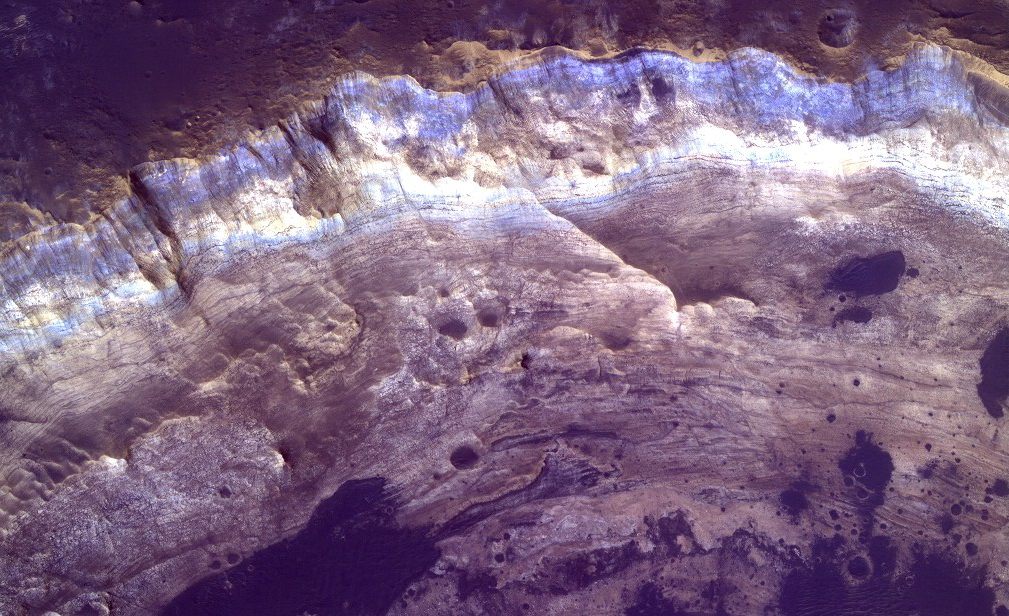
This image covers an impact crater roughly 4 kilometers (2.5 miles) in diameter. The portion highlighted shows a one kilometer segment of the crater wall and rim.
The surface outside the crater is relatively dark, while the interior wall of the crater exposes lighter, layered bedrock of diverse colors. A few dark patches on the crater wall have small dunes or ripples on their surfaces, and are likely pits filled with dark sand. The crater provides a window into the subsurface of Mars, revealing layered sedimentary deposits.
Just 30 kilometers (20 miles) to the east of this crater lies Mawrth Vallis, an ancient channel that may have been carved by catastrophic floods. In layered deposits surrounding Mawrth Vallis, the orbiting spectrometers OMEGA (on Mars Express) and CRISM (on MRO) have detected phyllosilicate (clay) minerals, which must have formed in the presence of water. In this region on Mars, the colors of layers seen by HiRISE often correlate with distinct water-bearing minerals observed by CRISM, so the color diversity seen here may reflect a dynamic environment at this location on early Mars.
Note: The color in these images is enhanced; it is not as it would normally appear to the human eye.

West of Valles Marineris lies a checkerboard named Noctis Labyrinthus, which formed when the Martian crust stretched and fractured. As faults opened, they released subsurface ice and water, causing the ground to collapse. This westward view combines images taken during the period from April 2003 to September 2005 by the Thermal Emission Imaging System instrument on NASA's Mars Odyssey orbiter. It is part of a special set of images marking the occasion of Odyssey becoming the longest-working Mars spacecraft in history. The pictured location on Mars is 13.3 degrees south latitude, 263.4 degrees east longitude.
NASA's Mars Exploration Rover Opportunity approached Santa Maria Crater in December 2010. With a diameter of about 90 meters (295 feet), this crater is slightly smaller than Endurance Crater, which Opportunity explored for about half a year in 2004.
This image of Santa Maria Crater was taken by the High Resolution Imaging Science Experiment (HiRISE) camera on Mars Reconnaissance Orbiter.
The rover team plans to use Opportunity for investigating Santa Maria for a few weeks before resuming the rover's long-term trek toward Endeavour Crater. One planned target area is at Santa Maria's southeast rim. The red circle marked there on Figure 1 indicates the pixel size and location of an observation by the Compact Reconnaissance Imaging Spectrometer for Mars (CRISM) on NASA's Mars Reconnaissance Orbiter that has piqued researchers' interest. The spectrum recorded by CRISM for this spot, unlike the spectrum recorded for the place indicated by the blue circle on the floor of the crater, suggests what might be a water-bearing sulfate mineral. Although Opportunity has detected such minerals on the surface during its nearly seven years on Mars, none have been detected from orbit at a place visited by Opportunity.

A false-color mosaic focuses on one junction in Noctis Labyrinthus where canyons meet to form a depression 4,000 meters (13,000 feet) deep. Dust (blue tints) lies on the upper surfaces, while rockier material (warmer colors) lies below.
The pictures used to create this mosaic image were taken from April 2003 to September 2005 by the Thermal Emission Imaging System instrument on NASA's Mars Odyssey orbiter. It is part of a special set of images marking the occasion of Odyssey becoming the longest-working Mars spacecraft in history. The pictured location on Mars is approximately 13 degrees south latitude, 260 degrees east longitude.

This VIS image shows part of a landslide deposit in Melas Chasma.

This 4 kilometer diameter feature near the edge of the south polar residual cap was recognized in Mariner 9 and Viking Orbiter images taken in the 1970s, but its origin could not be inferred. It was therefore targeted for HiRISE stereo imaging.
The bright areas in this image are covered by carbon dioxide frost, and the "swiss cheese" terrain typical of the south polar residual cap covers much of the imaged area. The dark walls of the circular depression do not have as much frost on them, and are fractured in a polygonal pattern. Apparently the surface of the walls has been extensively modified by thermal expansion and contraction of water ice.
It also appears that the "swiss cheese" terrain of the residual cap has buried the floor of the circular depression, as well as the terrain surrounding the feature, making it difficult to infer the origin of this depression. Its circular symmetry is consistent with an impact origin, but there is no evidence of a crater rim or ejecta (perhaps because they have been buried). The depression may have formed by collapse, but there is little evidence of extensional fractures that would be expected around a collapse pit. Analysis of HiRISE stereo data may help the interpretation of this feature.

Although it is 45 kilometers (28 miles) wide, countless layers of ice and dust have all but buried Udzha Crater. Udzha lies near the edge of the northern polar cap, and only the topmost edges of its crater rim rise above the polar deposits to hint at its circular shape.
The image was taken by the Thermal Emission Imaging System instrument on NASA's Mars Odyssey orbiter and posted in a special December 2010 set marking the occasion of Odyssey becoming the longest-working Mars spacecraft in history. The pictured location on Mars is 81.8 degrees north latitude, 77.2 degrees east longitude.

Layered material surrounds in this unnamed crater in Terra Sabaea.

This image shows part of the floor of Rabe Crater, a large (108 kilometers, or 67 miles in diameter) impact crater in the southern highlands.
Dark dunes — accumulations of wind blown sand — cover part of crater's floor, and contrast with the surrounding bright-colored outcrops. The extreme close-up view reveals a thumbprint-like texture of smaller ridges and troughs covering the surfaces of the larger dunes. These smaller ripples are also formed and shaped by blowing wind in the thin atmosphere of Mars.
One puzzling question is why the dunes are dark compared with the relative bright layered material contained within the crater. The probable answer is that the source of the dark sand is not local to this crater; rather, this topographic depression has acted as a sand trap that has collected material being transported by winds blowing across the plains outside the crater.

Sand dunes shaped like blue-black flames lie next to a central hill within an unnamed, 120-kilometer-wide (75-mile-wide) crater in eastern Arabia on Mars. False colors depict the nature of the ground surface: areas in bluish tints have more fine sand at the surface, while redder tints indicate harder sediments and outcrops of rock.
This scene combines images taken during the period from February 2003 to August 2004 by the Thermal Emission Imaging System instrument on NASA's Mars Odyssey orbiter. It is part of a special set of images marking the occasion of Odyssey becoming the longest-working Mars spacecraft in history. The pictured location on Mars is 26.7 degrees north latitude, 63 degrees east longitude.

This VIS image shows a small portion of the northern escarpment of Olympus Mons. The semi-circular deposit on the left side of the frame is a large landslide deposit.

Chasma Boreale is a long, flat-floored valley that cuts deep into Mars' north polar ice cap. Its walls rise about 1,400 meters (4,600 feet) above the floor. Where the edge of the ice cap has retreated, sheets of sand are emerging that accumulated during earlier ice-free climatic cycles. Winds blowing off the ice have pushed loose sand into dunes and driven them down-canyon in a westward direction, toward our viewpoint.
This scene combines images taken during the period from December 2002 to February 2005 by the Thermal Emission Imaging System instrument on NASA's Mars Odyssey orbiter. It is part of a special set of images marking the occasion of Odyssey becoming the longest-working Mars spacecraft in history. The pictured location on Mars is 84.9 degrees north latitude, 359.1 degrees east longitude.

Ceraunius Fossae is the region of fractures and volcanic flows south of Alba Mons.

If a meteorite breaks in two shortly before hitting the ground, the typical bowl shape of a single impact crater becomes doubled. The two circular blast regions intersect, creating a straight wall separating the two craters. At the same time, "wings" of ejected debris shoot out to the side. The image covers an area 13 kilometers (8 miles) wide.
This picture was taken in May 2005 by the Thermal Emission Imaging System instrument on NASA's Mars Odyssey orbiter and posted in a special December 2010 set marking the occasion of Odyssey becoming the longest-working Mars spacecraft in history.

The triple tails of windstreaks behind these small craters in Arabia Terra indicate multiple wind directions in the area.

A vast dune field lies near the northern polar cap of Mars. Seen here in summer, the dunes have partially buried an impact crater about 1,000 meters (3,300 feet) wide.
This image was taken in August 2010 by the Thermal Emission Imaging System instrument on NASA's Mars Odyssey orbiter and posted in a special December 2010 set marking the occasion of Odyssey becoming the longest-working Mars spacecraft in history. The pictured location on Mars is 79.1 degrees North latitude, 245.5 degrees East longitude.