Monday, March 31, 2014

Large, Banded Angular Fragment in Nili Fossae


In a Context Camera (CTX) image, there is a large angular fragment that appears to have light and dark-toned bands. HiRISE images of similar fragments nearby also show this banding, and the resolution of our camera may help determine what these layers are.

Nili Fossae was once considered a potential landing spot for the Mars Science Laboratory, and has one of the largest, most diverse exposures of clay minerals. Clay minerals contain water in their mineral structure and may preserve organic materials.

Photo credit: NASA/JPL/University of Arizona

Sunday, March 30, 2014

Pitted Mound in Northeast Arabia Terra


This fascinating observation shows us a dark-toned mound with pits inside an impact crater. Are these pits the result of sublimation?

The crater itself is an ancient one, as evidenced by the eroded rim. For the mound inside, HiRISE resolution can give us a closer look at textural features that might help explain what we're looking at: layers in pit walls, or perhaps cracks from expansion?

This is a stereo pair with ESP_034324_2040.

Photo credit: NASA/JPL/University of Arizona

Saturday, March 29, 2014

Windstreaks in Tartarus Montes


A long, narrow windstreak has formed in the lee of this hill in the Tartarus Montes. Several small dark craters also have windstreaks.

Orbit Number: 53874 Latitude: 13.993 Longitude: 168.415 Instrument: VIS Captured: 2014-02-04 20:57

Photo credit: NASA/JPL-Caltech/Arizona State University

Unusual Mound in Arabia Terra


With its cracked, blistery appearance, this mound near the center of a very large, over 5-kilometer diameter mid-latitude crater poses an interesting question: how did this form?

More importantly, what is the relationship between the mound and the surrounding, viscous features? Did those flow features play a role in forming the mound? Can that material help explain the cracked surface of the mound?

This is a stereo pair with ESP_034287_2185.

Photo credit: NASA/JPL/University of Arizona

Friday, March 28, 2014

Slope Streaks in Lycus Sulci


Dark slope streaks are a common feature on the cliff faces of Lycus Sulci.

Orbit Number: 53872 Latitude: 26.4392 Longitude: 227.913 Instrument: VIS Captured: 2014-02-04 16:56

Photo credit: NASA/JPL-Caltech/Arizona State University

Bedrock in a Trough in Asimov Crater


This image was acquired in southern winter over part of Asimov Crater (latitude 47.5 S), showing the equator-facing slope of a deep trough inside the crater. The crater appears to have been completely filled by a thick sequence of materials, perhaps including sediments and lava flows.

Later, deep troughs formed around the outer edge of the fill material<, probably by collapse over void spaces at depth. What made the void space is not known, but one idea is that there were lenses of ice that slowly sublimated into the atmosphere. Another idea is that this is part of a sequence of crater fill and "exhumation", that includes Gale Crater (home of the Curiosity rover). In other words, continued collapse and erosion of Asimov crater could eventually lead to a central mound like Eolis Mons (popular known as "Mt. Sharp") in Gale Crater. However, at Asimov crater, the southern trough has destroyed the southern rim of the original crater, which didn't happen at Gale Crater.

Many of these steep trough slopes in Asimov crater, where facing the equator, have recurring slope lineae (RSL) activity in the summer when the sun-facing slopes get warm. The RSL fade in the winter, so none are seen in this image even if they were present last summer. There are no previous HiRISE images acquired in the summer over this location.

Asimov Crater was named after Isaac Asimov, professor of biochemistry and prolific writer of science fiction and popular science books.


Photo credit: NASA/JPL/University of Arizona

Thursday, March 27, 2014

Acheron Catena


This VIS image shows several of the graben (fault bounded depression) that are part of Acheron Catena. Most of the lava flows in the image originated at Alba Mons and predate the graben.

Orbit Number: 53871 Latitude: 35.0865 Longitude: 258.1 Instrument: VIS Captured: 2014-02-04 14:55

Photo credit: NASA/JPL-Caltech/Arizona State University

Wednesday, March 26, 2014

Lava Flows From Alba Mons


Today's VIS image shows lava flows from Alba Mons.

Orbit Number: 53834 Latitude: 35.6081 Longitude: 244.876 Instrument: VIS Captured: 2014-02-01 13:50

Photo credit: NASA/JPL-Caltech/Arizona State University

Outcrop Near The Kimberley


This 360-degree panorama from NASA's Curiosity Mars rover is centered southward toward a planned science waypoint at "the Kimberley," with an outcrop of eroded sandstone in the foreground. It combines several frames taken by the Navigation Camera (Navcam) high on the rover's mast, during the 574th Martian day, or sol, of Curiosity's work on Mars (March 18, 2014).

The mission's prime science destinations are on the lower slope of Mount Sharp, which is on the horizon of this scene. North is at both ends of the panorama, which is presented as a cylindrical projection.

Image credit: NASA/JPL-Caltech

Note: For more information, see PIA18070: Panorama With Sandstone Outcrop Near 'The Kimberley' Waypoint (Stereo) and NASA Mars Rover's Next Stop Has Sandstone Variations.

Tuesday, March 25, 2014

Lava Flows and Channel Northeast of Olympus Mons


The small channel and lava flows in this VIS image are located northeast of Olympus Mons.

Orbit Number: 53822 Latitude: 29.858 Longitude: 229.899 Instrument: VIS Captured: 2014-01-31 14:10

Photo credit: NASA/JPL-Caltech/Arizona State University

Differential Erosion in Sandstone Layering Within Gale Crater


Sandstone layers with varying resistance to erosion are evident in this Martian scene recorded by the Mast Camera (Mastcam) on NASA's Curiosity Mars rover. The component images were taken by the Mastcam's left-eye camera shortly before midday of the 553rd Martian day, or sol, of the rover's work on Mars (February 25, 2014). The location is about one-quarter mile (about 400 meters) north-northwest of a planned waypoint called "the Kimberley," by straight-line distance, longer by driving distance.

Differing degrees of resistance to erosion result in a stair-stepped pattern visible here. Steeper steps result from more resistant rock, so the flat, tan surface is a weakly resistant sandstone. The small steps to the right center are a bit more resistant, and the steeper steps near the top of the scene are even more resistant.

The image has been white-balanced to show what the rocks would look like if they were on Earth. A version with superimposed scale bars is available as Figure A; the bars at different locations and orientations in the scene are labeled for lengths of 200 to 300 centimeters (79 to 118 inches). A version with raw color, as recorded by the camera under Martian lighting conditions, is available as Figure B.

Image credit: NASA/JPL-Caltech/MSSS

Note: For more information, see NASA Mars Rover's Next Stop Has Sandstone Variations.

Saturday, March 22, 2014

Channel in Hebrus Valles


This VIS image shows a portion of Hebrus Valles. The flow of liquid (water or lava) is from the bottom of the image into the circular feature, which was likely filled by the material from the channel. The channel continues, exiting out of the circular feature to the northwest (just outside the image boundary).

Orbit Number: 53813 Latitude: 19.277 Longitude: 127.727 Instrument: VIS Captured: 2014-01-30 20:27

Photo credit: NASA/JPL-Caltech/Arizona State University

Friday, March 21, 2014

Tartarus Colles


The hills in this VIS image are part of Tartarus Colles. Several of the hills have dark slope streaks, believed to be formed by downslope removal of dust revealing the darker rock beneath.

Orbit Number: 53811 Latitude: 26.2606 Longitude: 186.421 Instrument: VIS Captured: 2014-01-30 16:28

Photo credit: NASA/JPL-Caltech/Arizona State University

Thursday, March 20, 2014

Alba Mons Lava Flows


Today's VIS image shows a small portion of the lava flows from Alba Mons. The depression and collapse features within it are part of the large system of tectonic features created by the apparent collapse of the volcano.

Orbit Number: 53809 Latitude: 32.2307 Longitude: 245.056 Instrument: VIS Captured: 2014-01-30 12:29

Photo credit: NASA/JPL-Caltech/Arizona State University

New Gully Channel in Terra Sirenum


Gully, or ravine, landforms are commonly found in the mid-latitudes on Mars, particularly in the Southern highlands. These features typically have a broad upslope alcove, feeding into a channel and apron of debris that has been carried from above.

HiRISE has discovered many examples of activity in these gullies, likely driven by seasonal carbon dioxide (dry ice) frost. Images to look for such changes have been key targets for HiRISE in recent years, as we seek to understand the full range of surface processes that are active today.

This area was targeted to look for changes in gullies previously covered by ESP_020051_1420 and ESP_013115_1420. Comparing the newer and older images, we see that a substantial new channel formed sometime between November 2010 and May 2013. Material flowing down from the alcove broke out of the old route, eroded a new channel, and formed a deposit on the apron.

Observations like this show that gullies are forming today. Although we cannot pin down the season of this event, locations where HiRISE has been able to image more often demonstrate that this sort of event generally occurs in the winter, when liquid water is very unlikely. Despite their resemblance to water-formed ravines on Earth, carbon dioxide may play a key role in the formation of many Martian gullies.


Photo credit (top): NASA/JPL/University of Arizona; (bottom) NASA/JPL-Caltech/University of Arizona

Note: For more information, see NASA Orbiter Finds New Gully Channel on Mars and PIA17958: A New Gully Channel in Terra Sirenum, Mars.

Wednesday, March 19, 2014

Windstreaks Between Alba Mons and Acheron Fossae


Today's VIS image shows windstreaks on the volcanic surface between Alba Mons and Acheron Fossae.

Orbit Number: 53722 Latitude: 31.5024 Longitude: 233.118 Instrument: VIS Captured: 2014-01-23 08:04

Photo credit: NASA/JPL-Caltech/Arizona State University

Tuesday, March 18, 2014

Delta Deposit Near Ismenius Cavus


A delta deposit is located where a channel enters Ismenius Cavus.

Orbit Number: 53717 Latitude: 33.7284 Longitude: 17.5608 Instrument: VIS Captured: 2014-01-22 22:04

Photo credit: NASA/JPL-Caltech/Arizona State University

Monday, March 17, 2014

Impact Crater in Hesperia Planum


Sandwiched between a crater nearly 4 kilometer across and a much larger and older crater over 15-kilometers in diameter is this small impact crater with light-toned material exposed in its ejecta.

Because the material is still brighter than the surrounding surface, darker dust settling out of the atmosphere has not had time to cover it up, so the crater is fairly recent. Of course, “recent” could mean on the order of thousands of years or older. This small crater is also fairly shallow and smooth in its interior.

This light-toned rock deposit is also visible along neighboring scarps and even in the rock strata exposed along the rim of the larger 15-kilometer crater, indicating that the formation of this rocky strata predates all of these craters. The brightness and color of these deposits are the result of different minerals within the rock relative to the nearby darker rocks and soils, and perhaps indicate extensive chemical interaction between water and the native rocks.

Photo credit: NASA/JPL/University of Arizona

Note: This impact crater is located in Hesperia Planum, northeast of Tyrrhena Patera.

Sunday, March 16, 2014

Impact Crater Ejecta Blanket in Utopia Planitia


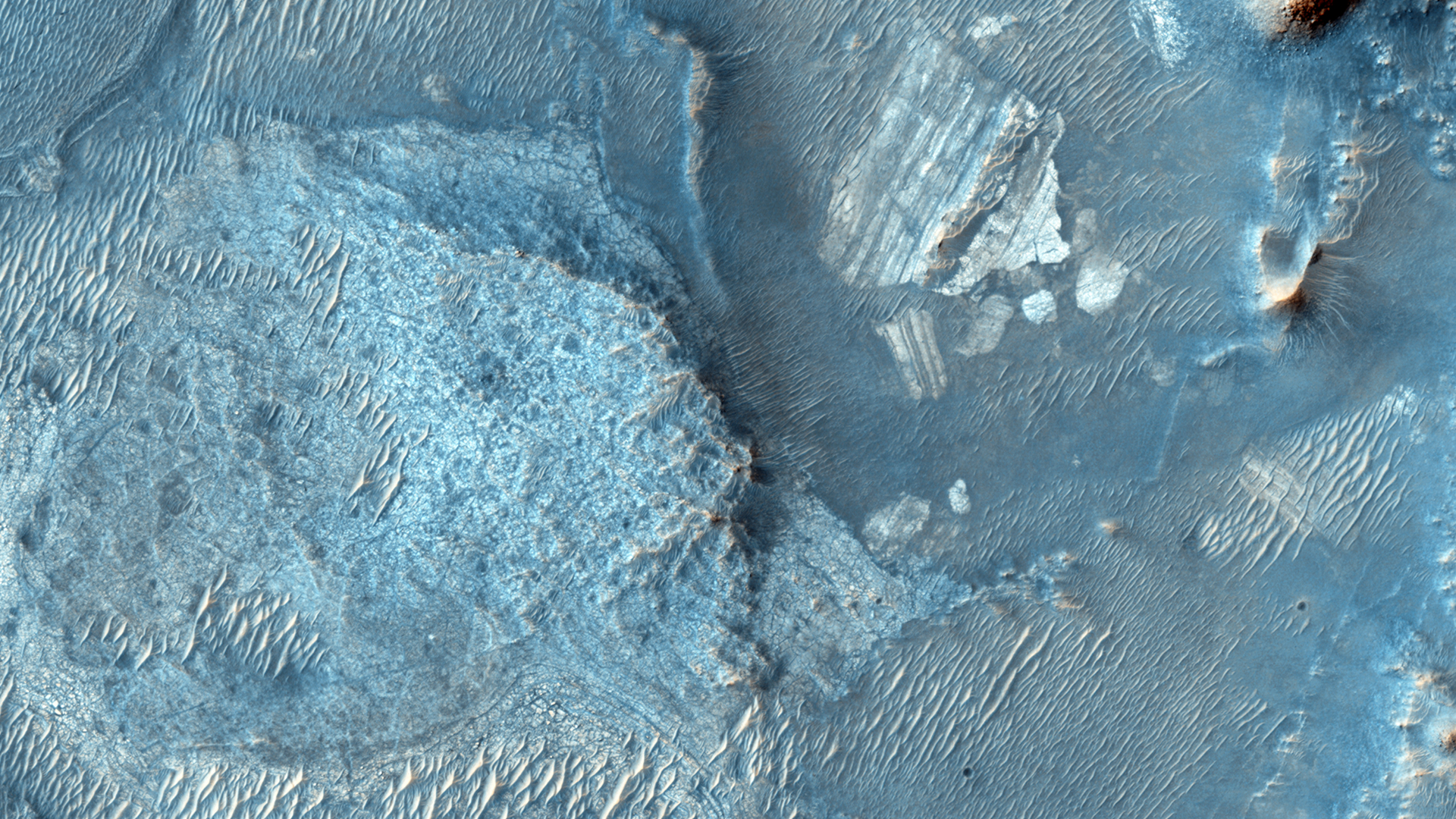
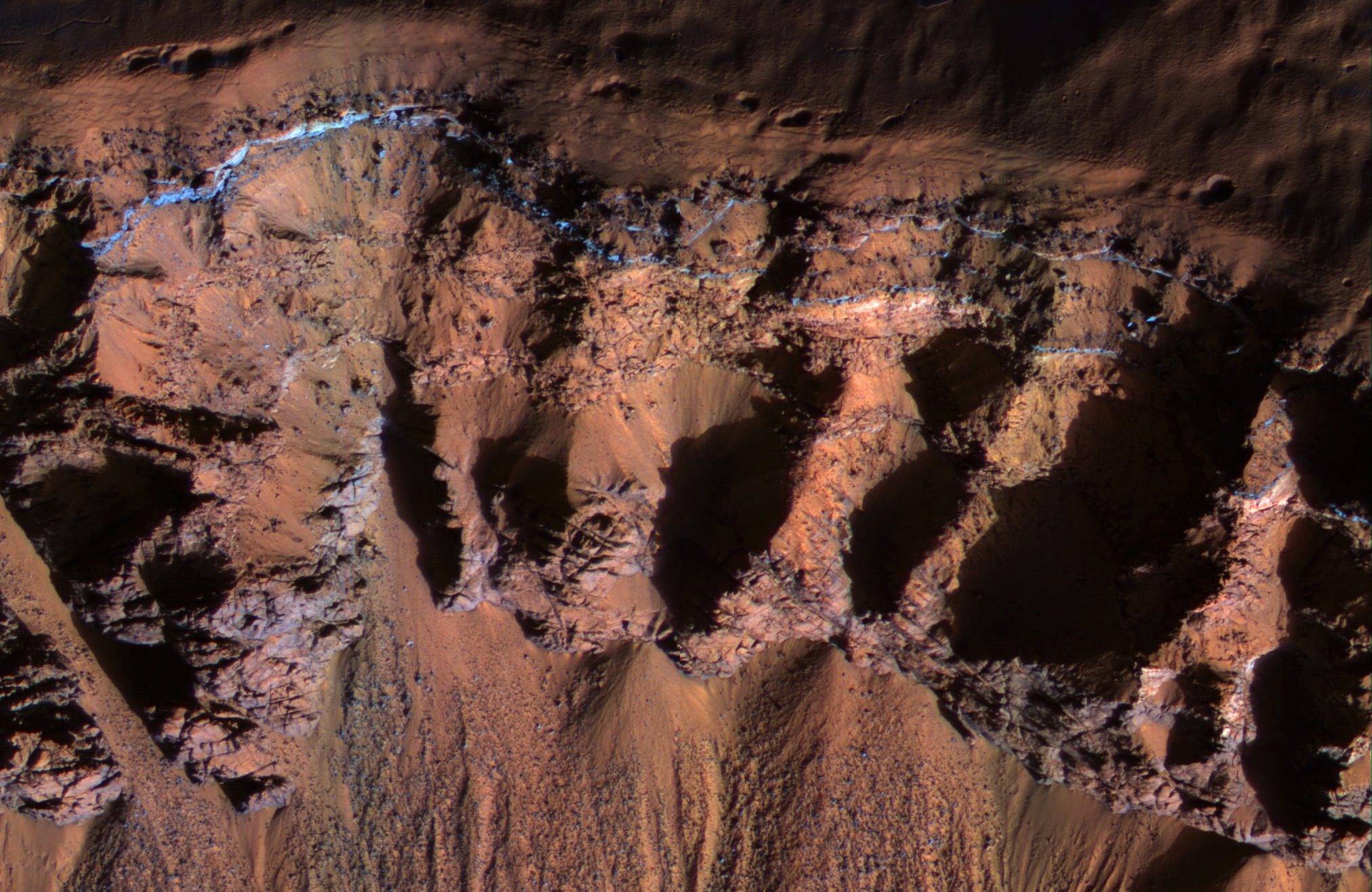
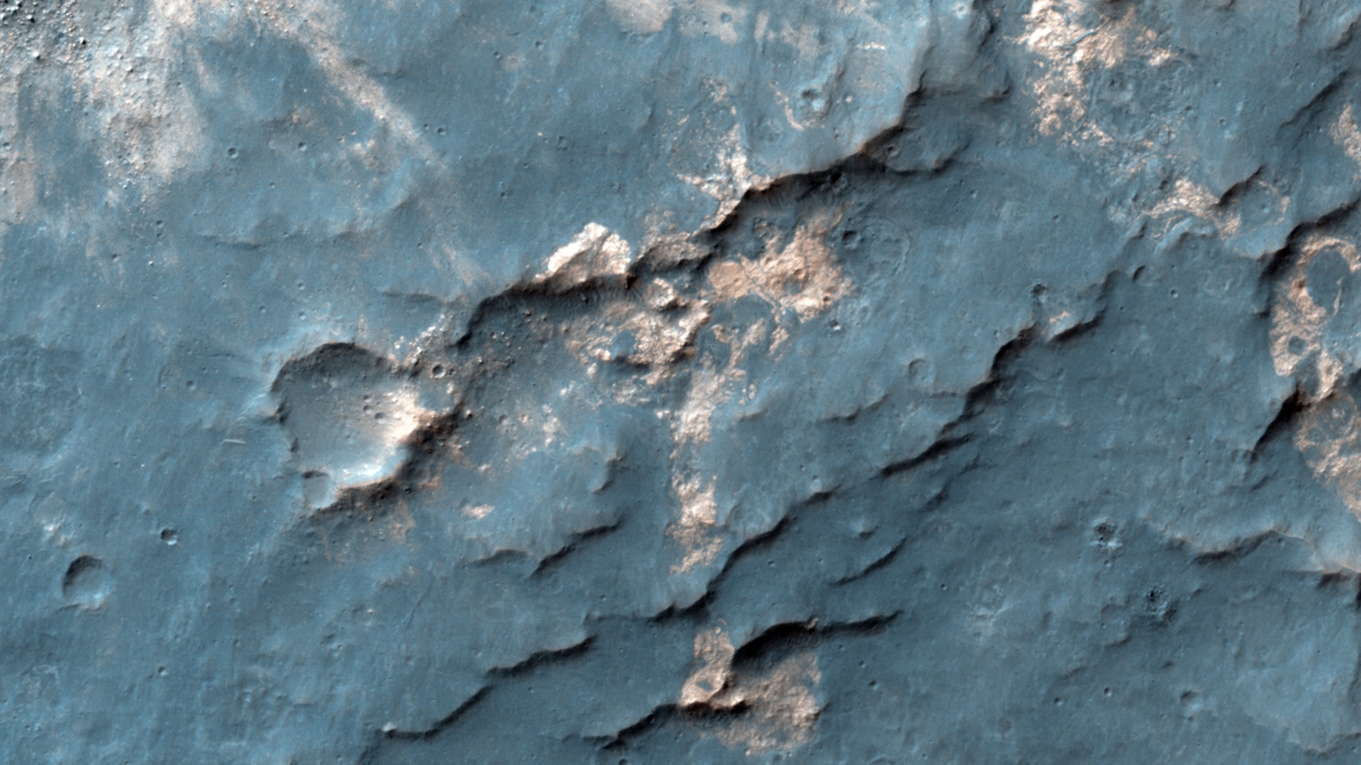
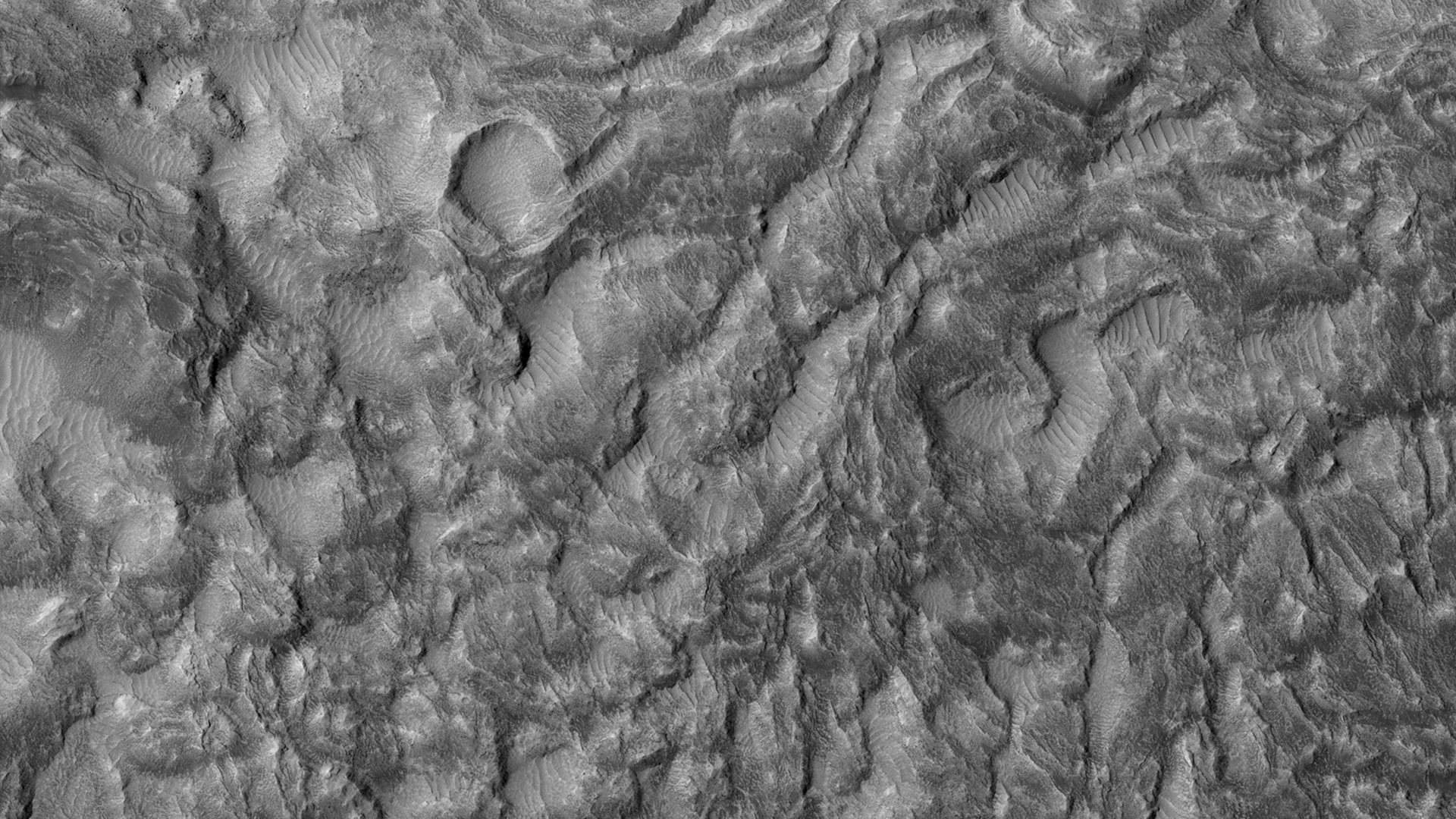
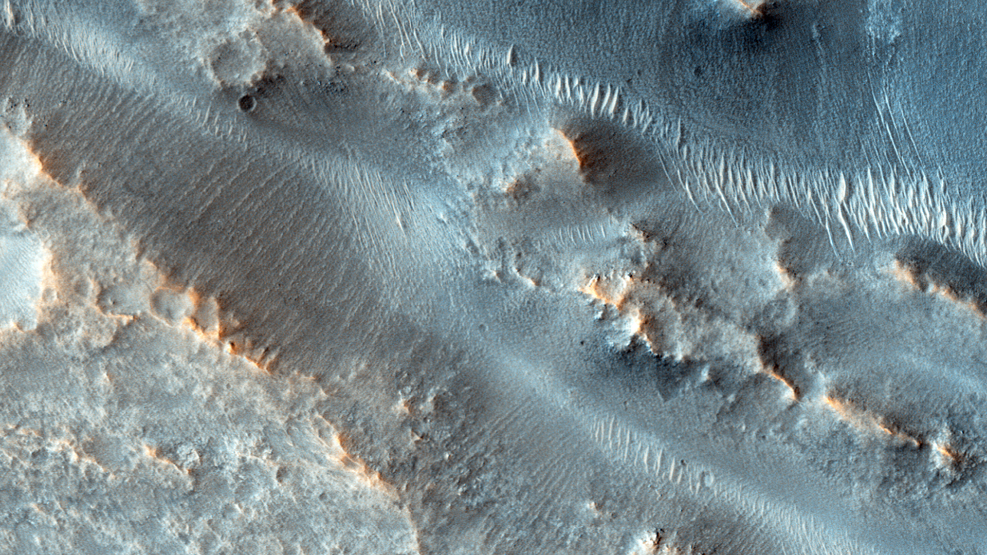
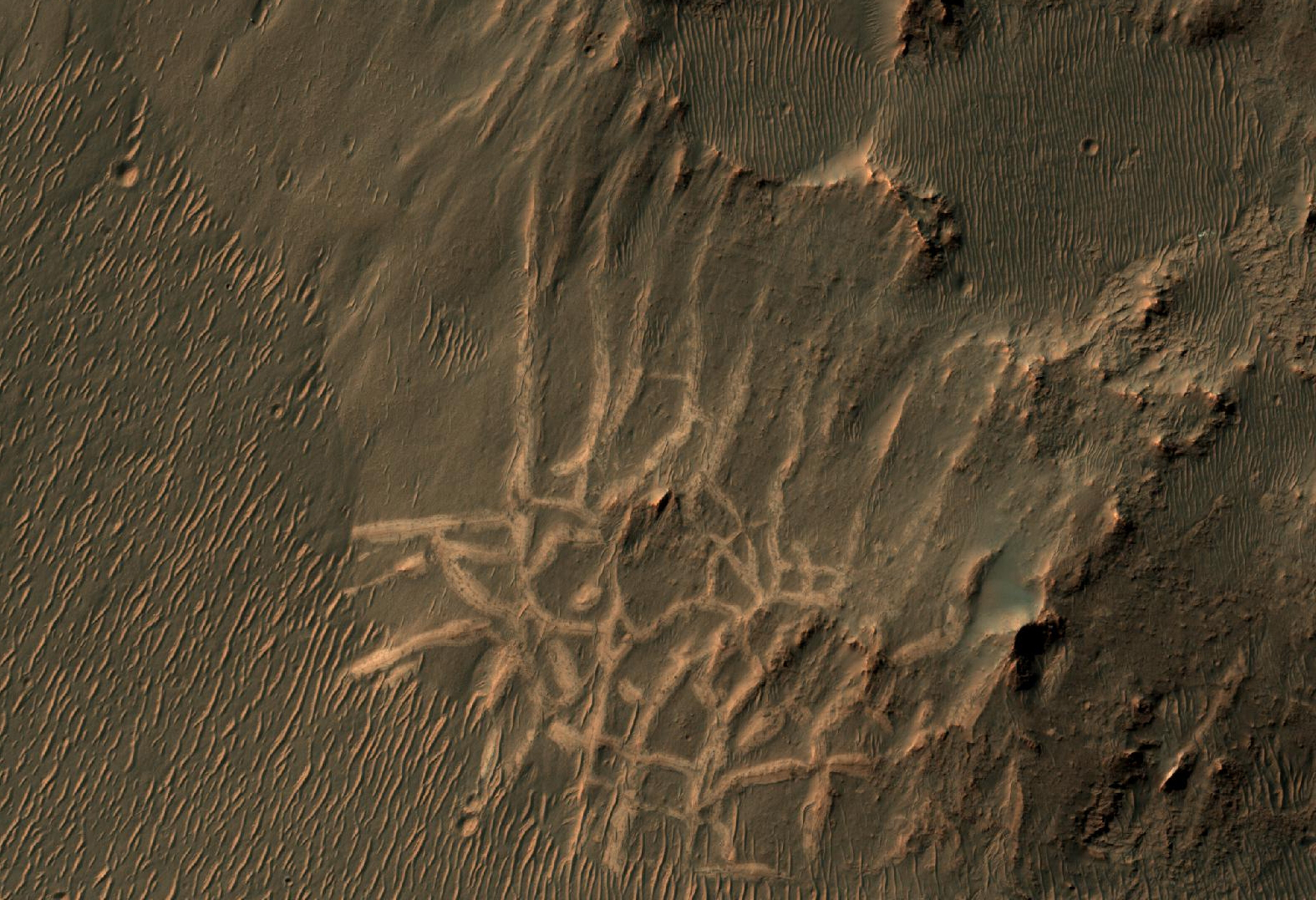
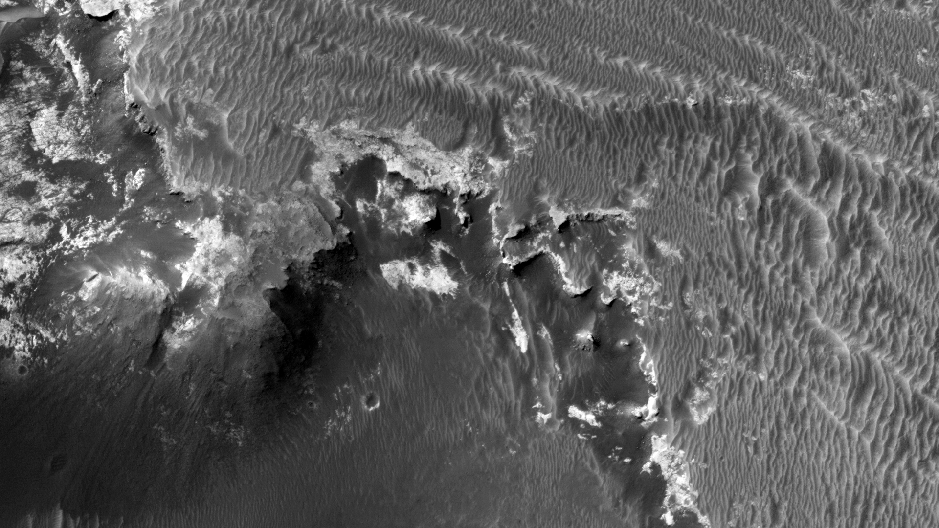
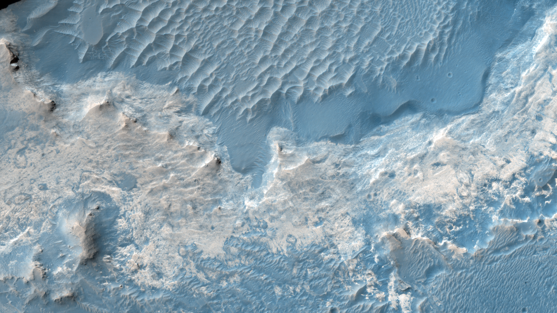
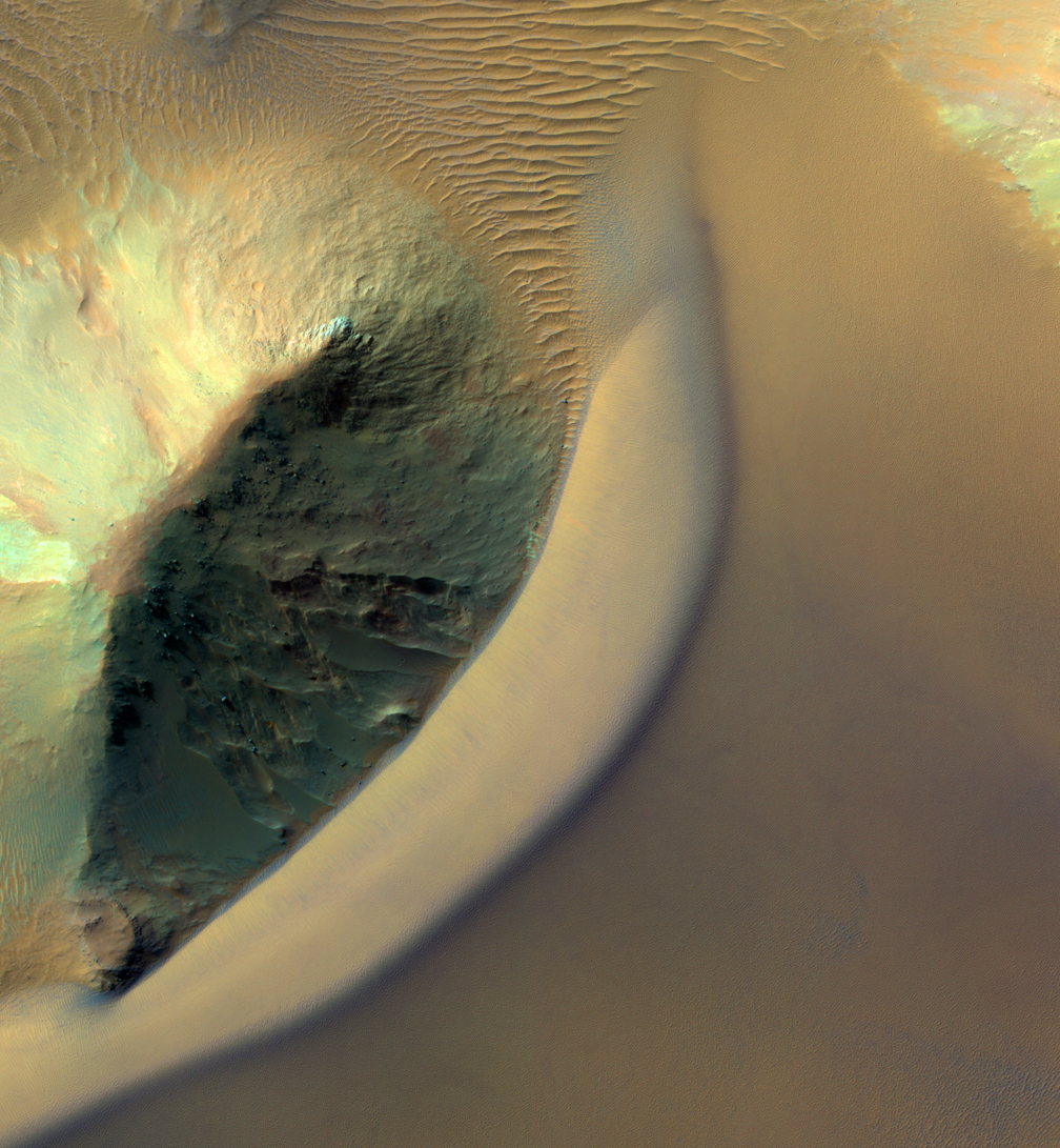
When impact craters are formed, the material that once resided in the subsurface is blown upward and outward. This material falls back and settles around the newly formed crater into what is called an “ejecta blanket.” It often appears as a layer on top of the original surface extending radially outward from the crater.

In some cases the volume of the ejecta material—mainly rocky debris—appears to exceed the volume of the original crater, presenting something of a puzzle. One hypothesis is that the original surface may have been inflated with an ice-rich layer at the time of the impact. After the impact, the newly formed blanket of ejecta then protected this ice from evaporation loss, while the rest of the surrounding terrain was unprotected and deflated as ice was lost due to more recent climate changes.

Examining these craters up close with HiRISE may reveal clues to the presence of buried ice deposits today beneath the ejecta, and about the subsurface stratigraphy exposed along the crater walls.

Photo credit: NASA/JPL/University of Arizona

Note: This impact crater is located near the southeastern "beach" of Utopia Planitia, northwest of Elysium Mons.

Saturday, March 15, 2014

Gordii Fossae


The channels and depressions in this VIS image are part of Gordii Fossae, located on the volcanic plains between Olympus Mons and Gigas Sulci.

Orbit Number: 53697 Latitude: 13.0526 Longitude: 231.156 Instrument: VIS Captured: 2014-01-21 07:23

Photo credit: NASA/JPL-Caltech/Arizona State University

Complex Valley Network Near Idaeus Fossae


Many valleys occur all over Mars that reveal an extensive ancient history of liquid water erosion. While these valley systems are typically now covered with fine soils and sand dunes, the overall scale and shape of the valleys reveals much about the ancient climate.

The speed, volume, and extent of the flowing water can be apparent from how it interacts with obstacles. For example, large volumes of rapidly flowing water may overtop obstacles rather than be diverted around them. Or, a small stream flowing for an extend period may gradually cut downward through hard rock obstacles.

In this case, the valleys cut through a small, kilometer size impact crater. As it did so, the flow appears to have divided it into as many as three streams and then coalesced as it exited the other side.

Photo credit: NASA/JPL/University of Arizona

Friday, March 14, 2014

Lava Flows Northeast of Olympus Mons


Today's VIS image shows lava flows that originated at Olympus Mons.

Orbit Number: 53697 Latitude: 20.8278 Longitude: 232.261 Instrument: VIS Captured: 2014-01-21 07:21

Photo credit: NASA/JPL-Caltech/Arizona State University

Frost-Covered Dunes in Noachis Terra East of Proctor Crater


This image of a sand dune field in a Southern highlands crater was acquired when the Sun was just 5 degrees above the horizon. As a result, the image is mostly shadows, with sharply-delineated dune crests sticking up into the sunlight.

The especially bright patches—bluish in enhanced color—are due to seasonal frost that is accumulating as this hemisphere approaches winter.

Photo credit: NASA/JPL/University of Arizona

Note: For more information, see PIA18118: Dramatic Dune Destination. This impact crater is located just east of Proctor Crater.

Thursday, March 13, 2014

Streamlined Islands in Kasei Valles


This VIS image shows streamlined islands within part of Kasei Valles.

Orbit Number: 53695 Latitude: 28.1915 Longitude: 290.972 Instrument: VIS Captured: 2014-01-21 03:21

Photo credit: NASA/JPL-Caltech/Arizona State University

Wednesday, March 12, 2014

Dust Devil Tracks in Utopia Planitia


Today's VIS image shows dust devil tracks covering most of the surface in this region of Utopia Planitia.

Orbit Number: 53677 Latitude: 53.5237 Longitude: 94.6408 Instrument: VIS Captured: 2014-01-19 15:40

Photo credit: NASA/JPL-Caltech/Arizona State University

Tuesday, March 11, 2014

Channels on the Northwest Flank of Hecates Tholus


Multiple channels dissect the northwestern flank of Hecates Tholus in this VIS image.

Orbit Number: 53650 Latitude: 33.3016 Longitude: 149.105 Instrument: VIS Captured: 2014-01-17 10:27

Photo credit: NASA/JPL-Caltech/Arizona State University

Lava Flows in Daedalia Planum


Close-up view of the two dominant lava flows that reach the foot of the highland terrain (seen at the top of the image in this orientation). The older of the two eruptions produced the smooth lava surface to the south of the island (right), which later experienced extensive faulting. The younger lava flow (left) has a rougher texture and overlies the faulted lava plain, and therefore occurred later, with some of the lava flowing into the troughs. This region was imaged by the high-resolution stereo camera on ESA’s Mars Express on 28 November 2013 (orbit 12,593), with a ground resolution of 14 m per pixel.

Image credit: ESA/DLR/FU Berlin

Monday, March 10, 2014

Hummocks and Hollows in Planum Boreum


A bright ice cap of frozen water covers the North Pole of Mars. In the winter, thin coverings of carbon dioxide and water frost covers this area and these frosts finally disappear at the end of the Martian spring season.

In this image, the winter frosts are about to disappear and we can begin to see the surface features of the ice. The ice cap would be a bad place to get lost: it's one of the smoothest, flattest places on Mars so there are no landmarks visible. The surface features are gently rolling hummocks (or small mounds) and hollows about a meter (3 feet) in height and about 20 meters (60 feet) across. This monotonous landscape continues for hundreds of kilometers in every direction with this same repeating pattern.

Scientists do not know what makes this pattern so uniform over such large distances; we acquire HiRISE images like this one to look for small differences in these icy features from one place to another. Understanding this surface can help us understand the current climate and meteorological conditions at the North Pole of the Red Planet.

Photo credit: NASA/JPL/University of Arizona

Note: For more information, see PIA18111: Don't Get Lost in the North Polar Ice Cap.

Sunday, March 9, 2014

Dunes in Spring South of Planum Boreum


Mars’ northern-most sand dunes are beginning to emerge from their winter cover of seasonal carbon dioxide (dry) ice. Dark, bare south-facing slopes are soaking up the warmth of the sun.

The steep lee sides of the dunes are also ice-free along the crest, allowing sand to slide down the dune. Dark splotches are places where ice cracked earlier in spring, releasing sand. Soon the dunes will be completely bare and all signs of spring activity will be gone.

Photo credit: NASA/JPL/University of Arizona

Note: For more information, see PIA18109: Sand Dunes in Spring

Saturday, March 8, 2014

Volcanic Features and Wind Streaks West of Sulci Gordii


This VIS image shows a small region between Olympus Mons and Sulci Gordii. There are lava flows, tectonic depressions and channels visible in the image. All the features are related to the volcanism.

Orbit Number: 53647 Latitude: 17.6235 Longitude: 233.319 Instrument: VIS Captured: 2014-01-17 04:37

Photo credit: NASA/JPL-Caltech/Arizona State University

Ridges in Erythraea Fossa


These light-toned ridges are found in a large fracture located east of Holden Crater and form a curious box-like pattern.

A hair-line fracture runs along the axis of each ridge line. The overall pattern spans several hundred meters across and individual ridges are several meters wide. Scientists are not sure how they formed yet, but some possible explanations suggest that mineral-rich ground water flowed out of the hairline fractures and deposited minerals at or near the surface as the water evaporated.

In addition, these minerals may have formed a cement along the fractures, making these patterns more resistant to subsequent erosion by wind or other processes. The resulting cemented ridges then stand high above the surrounding plains.

Photo credit: NASA/JPL/University of Arizona

Note: For more information, see PIA18112: Many Small Interesting Ridges in Erythraea Fossa.

Friday, March 7, 2014

Channels on Ceraunius Tholus


Multiple channels dissect the northern flank of Ceraunius Tholus in this VIS image.

Orbit Number: 53646 Latitude: 24.8376 Longitude: 263.181 Instrument: VIS Captured: 2014-01-17 02:36

Photo credit: NASA/JPL-Caltech/Arizona State University

Eroding Impact Crater in Sinus Meridiani


An approximately 1-kilometer impact crater located in northern Sinus Meridiani has formed along the boundary of two different terrain units. The western part of the crater has formed along a unit consisting of wind-blown basaltic materials that overlie light-toned units exposed in the crater wall.

To the east is a shallow circular depression several kilometers across that consists of multiple layers of light-toned deposits that have been eroding away. These deposits are dark in THEMIS night-time infrared and bright in day-time infrared images, suggesting that they are relatively fine grained and largely devoid of rocky materials.

Dark, fine-grained basaltic wind-blown material partially mantles these units and forms dunes throughout the region. Along the eastern rim region, the impact crater is eroding back into the terrain, forming scalloped inlets in the crater rim and re-exposing the multiple layers of light-toned deposits. Terracing is common along the eastern slope of the crater.

Turning our attention to the the western slope, we see that the rim is eroding back into the terrain more evenly. Although this slope lacks a scalloped appearance, the erosion of the top units appear to be more even and at a faster rate than the underlying light-toned deposits. Dark wind-blown basaltic dunes line the floor of the crater. Some possible explanations for the origin of these light-toned deposits are that they are altered volcanic ash or ancient lake deposits.

Photo credit: NASA/JPL/University of Arizona

Note: For more information, see PIA18110: A Crater Straddling Two Terrain Units.

Thursday, March 6, 2014

Fluid Ejecta in Chryse Planitia


Multiple overlapping lobes of ejecta are visible in the VIS image of an unnamed crater in Chryse Planitia.

Orbit Number: 53644 Latitude: 41.1461 Longitude: 323.411 Instrument: VIS Captured: 2014-01-16 22:33

Photo credit: NASA/JPL-Caltech/Arizona State University

Features Found in the Yamato Meteorite


This scanning electron microscope image shows spheroidal features embedded in a layer of iddingsite, a mineral formed by action of water, in a meteorite that came from Mars. An area with the spheres, circled in red, was found to have about twice as much carbon present as an area (circled in blue) without the spheres. This meteorite, named Yamato 000593, was found in Antarctica in 2000 and identified as originating from Mars. The scale bar at lower left is 1 micron.


This scanning electron microscope image of a polished thin section of a meteorite from Mars shows tunnels and curved microtunnels. The clay mineral iddingsite is present in this meteorite, named Yamato 000593, which was found in Antarctica in 2000 and identified as originating from Mars. The scale bar at lower left is 2 microns.

Image credits: (top) NASA; (bottom) NASA

Note: For more information, see NASA Scientists Find Evidence of Water in Meteorite, Reviving Debate Over Life on Mars.

Wednesday, March 5, 2014

Slope Streaks in Arabia Terra


Dark slope streaks are found everywhere on the inner rim of this unnamed crater in Arabia Terra.

Orbit Number: 53642 Latitude: 17.2407 Longitude: 17.3787 Instrument: VIS Captured: 2014-01-16 18:44

Photo credit: NASA/JPL-Caltech/Arizona State University

West of Dingo Gap


This scene looking back at where Curiosity crossed a dune at "Dingo Gap" combines several exposures taken by the Navigation Camera (Navcam) high on the rover's mast. The panorama is centered toward the east and spans about 225 degrees, from north-northwest at the left to west-southwest at the right. For scale, the distance between Curiosity's parallel wheel tracks is about 9 feet (2.7 meters). The panorama is presented here as a cylindrical projection.

The component images were taken during the 539th Martian day, or sol, of the rover's work on Mars (February 10, 2014) from a location reached by a drive the preceding sol. Curiosity crossed the dune at Dingo Gap, near the middle of the horizon of this scene, on Sol 535 (February 6, 2014). The dune is about 3 feet (1 meter) tall.

The high-mounted cylinder on the rear part of the vehicle is the rover's UHF (ultrahigh frequency) antenna. The set of disks mounted below it is part of the calibration target for Curiosity's Chemistry and Camera (ChemCam) instrument. The ball-on-a-stick device in the foreground is the calibration target, including a sundial, for Curiosity's Mast Camera (Mastcam). To the right of the UHF antenna in this image are the radiator fins for Curiosity's power supply, a radioisotope thermoelectric generator.

Image credit: NASA/JPL-Caltech

Note: For more information, see PIA17951: Panoramic View From West of 'Dingo Gap' (Stereo) and NASA's Curiosity Mars Rover Views Striated Ground.

Tuesday, March 4, 2014

Channels in Acheron Fossae


Numerous channels dissect the rim of this large crater located on Acheron Fossae.

Orbit Number: 53585 Latitude: 39.3278 Longitude: 224.156 Instrument: VIS Captured: 2014-01-12 02:02

Photo credit: NASA/JPL-Caltech/Arizona State University

Junda Outcrop


This landscape scene photographed by NASA's Curiosity Mars rover shows rows of rocks in the foreground and Mount Sharp on the horizon. Curiosity's Navigation Camera (Navcam) took the component images for this mosaic during a pause in driving on the 548th Martian day, or sol, of the rover's work on Mars (February 19, 2014). The Sol 548 drive covered 328 feet (100 meters).

Images taken from orbit and used in planning the rover's route toward lower slopes of Mount Sharp had piqued researchers interest in the striations on the ground that are formed by these rows of rocks. This particular outcrop is called "Junda." Similar striations are apparent on other patches of ground along the planned route.

The view is centered toward south-southeast and spans about 160 degrees. It is presented as a cylindrical projection. A stereo view of the scene is available at PIA17948. A look back from the end of the Sol 548 drive is available at PIA17949.

Image credit: NASA/JPL-Caltech

Note: For more information, see NASA's Curiosity Mars Rover Views Striated Ground

Monday, March 3, 2014

Gullies in a Libya Montes Impact Crater


Gully-like landforms, or ravines, are most common in the middle latitudes of Mars, but also occur in polar and equatorial latitudes.

We see here an impact crater about 900 meters wide, with distinct gullies on all inner slopes except in the northwest sector of the crater. The crater formed on the side of an ancient channel, so the northwestern section slumped into the channel, so the slopes are not as steep.

This region of Mars is called Libya Montes, near the equator on the south edge of the Isidis impact basin. These are typical gullies with alcoves at the top, channels, and depositional fans at the bottom, but the alcoves are relatively small compared with many other mid-latitude gullies. HiRISE has shown that gullies are actively forming today in the southern mid-latitudes, aided by the seasonal deposition of carbon dioxide frost or dry ice.

The equatorial gullies here appear pristine at the scale of HiRISE, with no superimposed craters or windblown deposits, so the gullies formed in the recent past and could still be forming today. Here in the Martian tropics, it is too warm for dry ice to help fluidize the movement of debris, but the slopes are probably steep enough for dry mass wasting to move dry particles, perhaps aided by water in the crust to reduce friction.

Photo credit: NASA/JPL/University of Arizona

Sunday, March 2, 2014

Frosty Dunes Near Bosporos Rupes


This Southern autumn image captures a view of frosty dunes. The sunlight is shining on the dunes from the upper right.

The low sun angle creates large shadows from these dunes, making for a dramatic picture. Frost is visible in the shadows of the dunes that appear as lighter or bluer swirls in each shadow. Along the illuminated section of the dunes, in the center-right of the image, five dark thin dust devil tracks are snaking their way along, parallel to the dune ridge. (North is to the left in this image, the image height covers 1.2 kilometers of the Martian surface.)

Photo credit: NASA/JPL/University of Arizona

Note: These dunes are located just to the east of Bosporos Rupes, which is to the northwest of Argyre Planitia.

Saturday, March 1, 2014

Channels on the Northeast Flank of Hecates Tholus


Several channels are located on the flank of Hecates Tholus. In this VIS image one of those channels enters a crater, creating a deposit on the floor of the crater. Age relationships can be derived from this image. Hecates Tholus was formed first, then the crater was created, and finally flow of lava or water carved the channel that bisects the crater rim.

Orbit Number: 53575 Latitude: 33.1381 Longitude: 151.349 Instrument: VIS Captured: 2014-01-11 06:19

Photo credit: NASA/JPL-Caltech/Arizona State University

Dunes Streaming Through Hills in Ganges Chasma


This dramatic image show dark rippled bodies of sand, sometimes in the form of dunes, streaming through Ganges Chasma. The floor of the canyon is covered by hills and mesas, perhaps remnants of chaotic terrain that formed from sudden collapse as water was withdrawn to form outflow channels.

The sand moving through (generally from east to west, or upstream) interacts with the topography to make streamlined shapes. A closeup image in enhanced-color shows one hill with a dune piling up to the east.

This is a stereo pair with ESP_033748_1720.

Photo credit: NASA/JPL/University of Arizona