
Numerous layers within Burroughs Crater are visible in this image.
Orbit Number: 50542 Latitude: -71.9548 Longitude: 115.03 Instrument: VIS Captured: 2013-05-06 15:07
Photo credit: NASA/JPL-Caltech/Arizona State University
Numerous layers within Burroughs Crater are visible in this image.
Orbit Number: 50542 Latitude: -71.9548 Longitude: 115.03 Instrument: VIS Captured: 2013-05-06 15:07

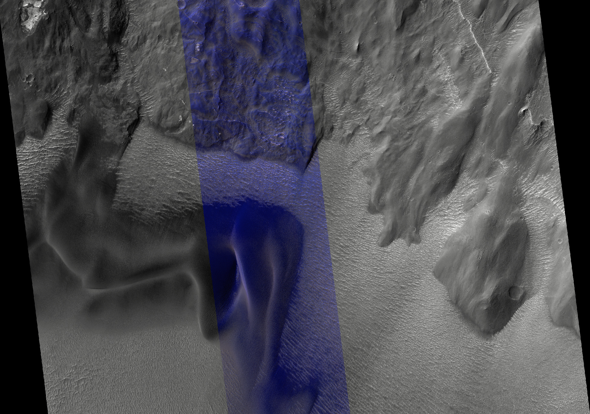
The edge of the south polar cap is the bright band in the center of this VIS image. Dunes fill the upper part of the image.
Orbit Number: 50541 Latitude: -71.9907 Longitude: 143.93 Instrument: VIS Captured: 2013-05-06 13:09

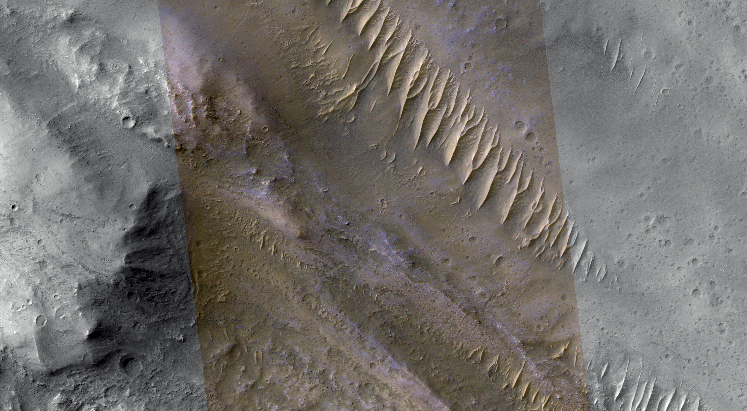
Today's VIS image show the tracks of dust devils on the rim of Stoney Crater.
Orbit Number: 50526 Latitude: -69.3584 Longitude: 217.793 Instrument: VIS Captured: 2013-05-05 07:30

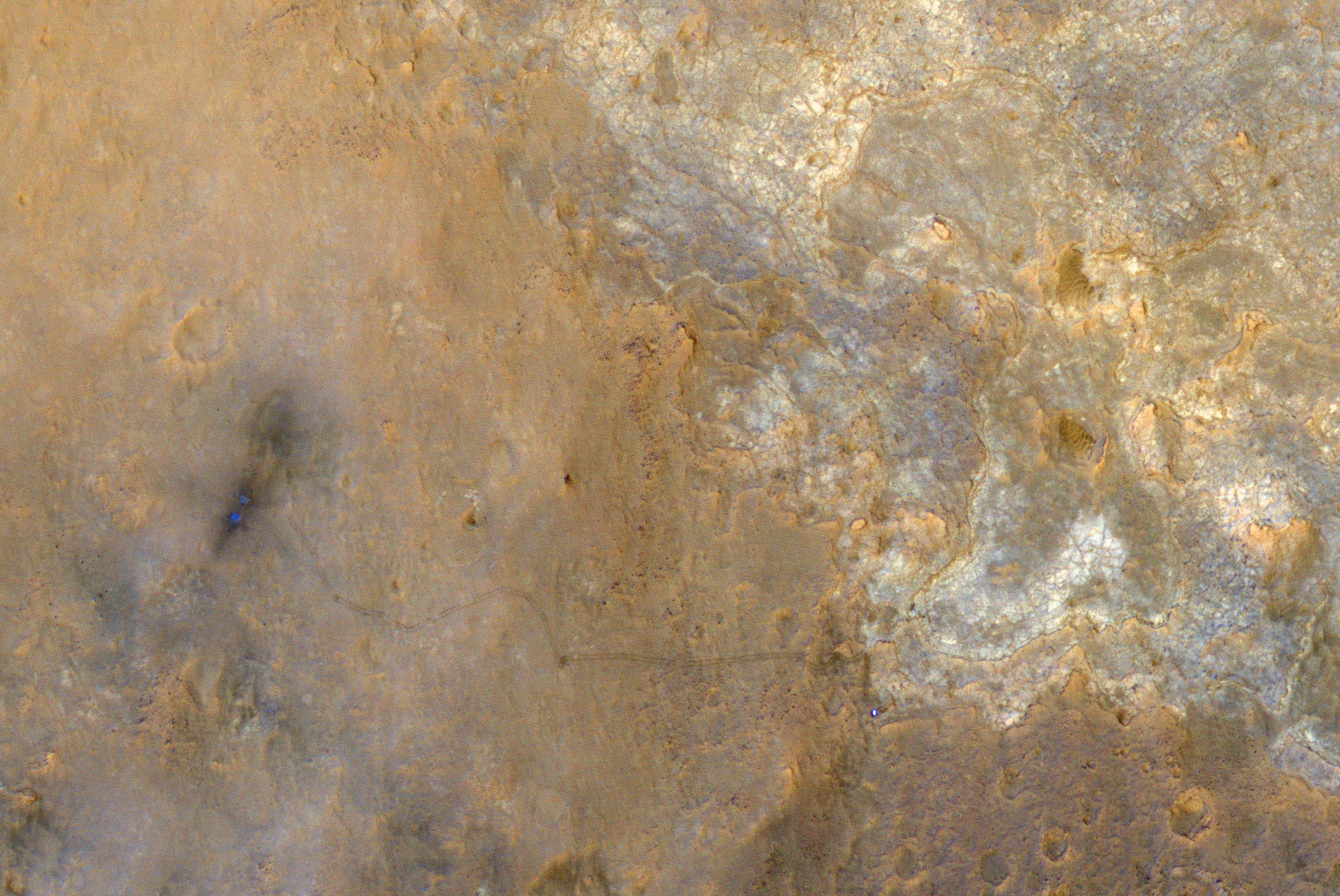
This image was acquired with a large spacecraft roll to the east when the subsolar latitude was -7.26 degrees, close to the latitude of MSL (-4.6 degrees), resulting in an image with the sun, the MRO spacecraft, and the MSL Curiosity rover on the surface all aligned in nearly a straight line (phase angle of just 5.47 degrees).
This geometry hides shadows and better reveals subtle color variations. With enhanced colors, we can view the region around the landing site and Yellowknife Bay. The rover is the very bright spot near the lower right. The rover tracks stand out clearly in this view, extending west to the landing site where two bright, relatively blue spots indicate where MSL's landing jets cleared off the redder surface dust.
The rover is now driving south towards the large mound in Gale Crater officially named Aeolis Mons and also called "Mount Sharp."

The linear ridges in this VIS image are located near the south polar cap.
Orbit Number: 50448 Latitude: -80.7785 Longitude: 294.276 Instrument: VIS Captured: 2013-04-28 21:31

This image spans from wall to wall across the center area of an impact crater. From what we see, a lot has happened to modify the appearance of the crater since it was formed, and this subsequent activity is the main interest of this observation.
First, the crater is no longer deep and bowl like: it is shallow and generally flat across its interior, indicating it has been filled with material. The small-scale relief features of this filled surface give clues as to what has happened. The parallel wavy ridges suggest that the material was able to move and flow, perhaps in several successive stages, and likely due to the presence of ice in the ground.
The fine scale pits and larger scale depressions suggest that more recently some of this ice may have disappeared by sublimating (changing from a solid directly to a gas) into the atmosphere, therefore deflating the surface. This story of deposition and loss of ice-rich material, possibly occurring over several cycles over the recent part of Mars' history (or longer, and possibly continuing today), is consistent with similar features in the broader region of the Utopia Basin.

The Mars Hand Lens Imager (MAHLI) camera on NASA's Curiosity rover is carried at an angle when the rover's arm is stowed for driving. Still, the camera is able to record views of the terrain Curiosity is crossing in Gale Crater, and rotating the image 150 degrees provides this right-side-up scene. The scene is toward the south, including a portion of Mount Sharp and a band of dark dunes in front of the mountain. It was taken on the 340th Martian day, or sol, of Curiosity's work on Mars, shortly after Curiosity finished a 329.1-foot (100.3-meter) drive on that sol. The drive was twice as long as any previous sol's drive by Curiosity.
When the robotic arm, turret, and MAHLI are stowed, the MAHLI is looking out from the front left side of the rover. This is much like the view from the driver's side of cars sold in the USA.
The main purpose of Curiosity's MAHLI camera is to acquire close-up, high-resolution views of rocks and soil at the rover's Gale Crater field site. The camera is capable of focusing on any target at distances of about 0.8 inch (2.1 centimeters) to infinity. This means it can, as shown here, also obtain pictures of the Martian landscape.

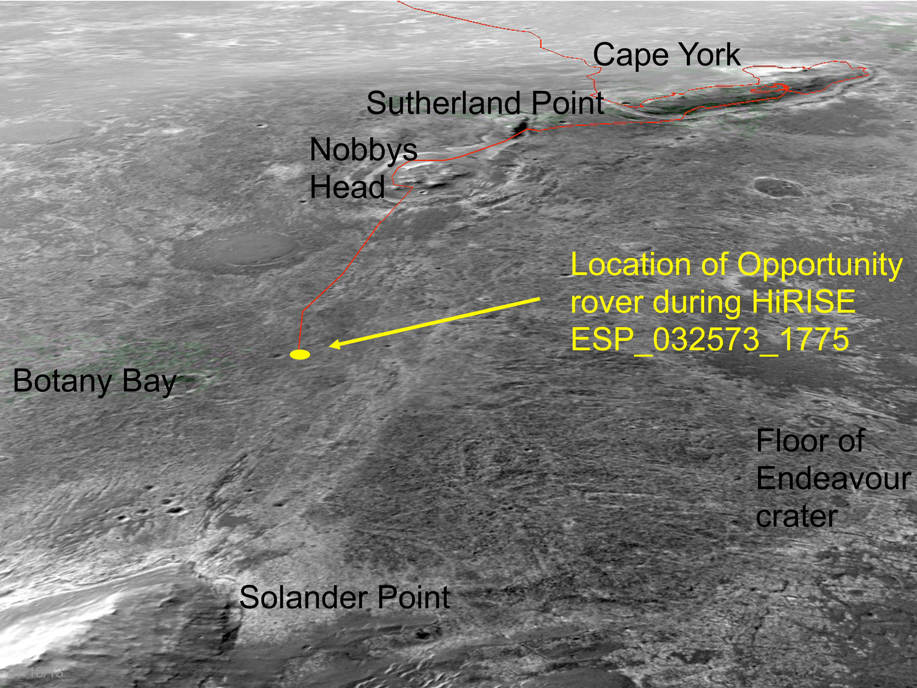
NASA's Mars Exploration Rover Opportunity has been on the western rim of Endeavour Crater in Meridiani Planum for about two years. Until May 2013, it was investigating sedimentary layers that are three to four billion years old on a portion of the rim called "Cape York." This image taken by the High Resolution Imaging Science Experiment (HiRISE) camera on NASA's Mars Reconnaissance Orbiter on July 8, 2013, captures Opportunity traversing south (at the end of the white arrow) to new science targets and a winter haven at "Solander Point," another portion of the Endeavour rim. The relatively level ground between Cape York and Solander Point is called "Botany Bay." The image was taken 10 years after Opportunity was launched from Florida on July 7, 2013, EDT and PDT (July 8, Universal Time).
Opportunity's destination at Solander Point is thought to have clay-bearing rocks (as detected from orbit) as part of well-exposed geological layers that could provide clues to Mars' watery past. In addition, north-facing slopes on Solander Point will increase the amount of solar energy the rover can collect during the upcoming Mars southern-hemisphere winter, allowing an active winter science campaign.
Opportunity investigated younger sedimentary units exposed in the smaller craters of Eagle, Endurance, and Victoria from early 2004 to mid-2009. By driving across Meridiani from Victoria to Endeavour Crater, and now from point-to-point on Endeavour's rim, Opportunity has set a new U.S. space program record for distance traversed on another planetary body, at greater than 22 miles or 36 kilometers.
Figure 1, an oblique, northward-looking view based on stereo orbital imaging, shows the location of Opportunity on its journey from Cape York to Solander Point when HiRISE took the new color image. Endeavour Crater is about 14 miles (22 kilometers) in diameter. The distance from Cape York to Solander Point is about 1.2 miles (2 kilometers). The red line indicates the path the rover has driven.
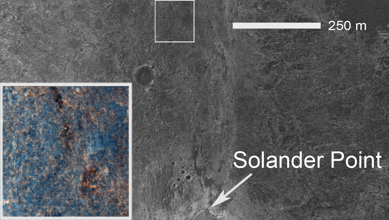
Figure 2 shows the location of the rover-containing section of new color image in relation to Solander Point. North is up. The scale bar is 250 meters (820 feet).
Figure 3 is an unannotated version of a section of the new color image including the rover.
This new image, HiRISE digital terrain modeling and cameras on Opportunity aid rover drivers in identifying safe routes. Additionally, they assist NASA geologists in finding attractive science targets for future investigation. The new image is one product from HiRISE observation ESP_032573_1775. Other products from the observation are at http://uahirise.org/ESP_032573_1775.

NASA's Curiosity Mars rover captured this image with its left front Hazard-Avoidance Camera (Hazcam) just after completing a drive that took the mission's total driving distance past the 1 kilometer (0.62 mile) mark. The image was taken on July 16, 2013, during the afternoon of 335th Martian day, or sol, of Curiosity's work on Mars. The view is in the direction of the next planned drive, toward the southwest. Portions of the rover's left and right front wheels are visible at the sides of the scene.
The Sol 335 drive covered about 125 feet (38 meters) and brought the mission's odometry to about 3,376 feet (1.029 kilometers). In early July 2013, the rover began a multi-month trek from the Glenelg area, where it worked for more than six months, toward a destination area of the lower layers of Mount Sharp, still about 5 miles (8 kilometers) away.

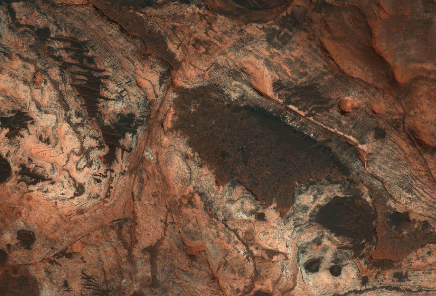
Excellent exposures of light-toned layered deposits occur along the northern edge of Hellas Basin, like those visible in this enhanced color image.
Some of these layered sediments have hydration features in CRISM data, and the various colors visible in this image suggests several different compositions may be present throughout the strata. The sediments may have been emplaced by hydrothermal activity associated with the impact event that created Hellas Basin.
Alternatively, they could be younger deposits that formed within this region when a lake existed here. Studies of the deposits using several data sets could distinguish between these two origins and may result in additional hypotheses for their formation.
This is a stereo pair with ESP_032425_1525.

Do you see what I see? These three side-by-side craters increase in size toward the bottom of the image. Looks like a snowman, only his eyes are missing.
Orbit Number: 44464 Latitude: 27.6878 Longitude: 43.2049 Instrument: VIS Captured: 2011-12-23 10:45

Landslides in Valles Marineris are truly enormous, sometimes stretching from one wall to the base of another. This 45-kilometer-long HiRISE image alone drops nearly 2 kilometers in elevation into Ius Chasma. This landslide, known as Ius Labes, would occupy the surface area of Delaware.
Here, we can see dark-toned material emanating from the landslide scarp and forming dunes and dark streaks that were carried downslope by the wind. Geologic context and compositional information from CRISM suggest this dune field was locally derived from landslide material. Other locations in this image show smaller ripples and smooth, rounded textures of the landslide, both attesting to long-lived wind transport and erosion.
This site records a long and complex geologic history of landscape evolution. This history likely includes: (1) ancient lava flows and ash fall deposits which were deposited horizontally and would eventually make what now is canyon wall material; (2) extensional forces rifted or faulted Valles Marineris; (3) mass wasting ensued where gravity forced weak and dislodged rock down into the canyon as massive landslides or smaller fans of boulders; (4) wind driven aeolian forces took small sand-sized particles to form dunes and ripples observable in this image, while also slowly eroding the landscape and modifying its shape.
The IAU Working Group for Planetary System Nomenclature has approved the name Martynov for a crater on Mars. For more information, see the map of MC-26 in the Gazetteer of Planetary Nomenclature.

This image shows a small portion of Mawrth Vallis, one of the many outflow channels feeding north into the Chryse Basin. This ancient valley once hosted flowing water. The erosive power of the flowing water rapidly cut down into the underlying layers of rock to expose a host of diverse geologic landforms visible today.
A focus of geologic study (at this site on Mars as well as many locations on Earth) is deciphering the juxtaposition of various rock structures and landforms. The superposition of one landform or strata above another, fractures and faults that disrupt one layer but not another, and the depths of certain mineralogical signatures all tell a story of the geological and climatological history of the region.
Intensely fractured bedrock is visible at all scales (meters to kilometers), revealing that subsurface rock has undergone a complex history of stresses and deformation, such as stretching, compression, and twisting. Wider dark ridges are also visible, crossing long distances through the fractured bedrock and between the various exposed layers. These ridges may be what geologists call "dikes," near vertical fissures in the subsurface rock that became injected with magma, and which later cooled into the is now an exposed vein of dark volcanic rock.
These dikes may be related to areas of dark and rough (likely volcanic) cap rock that now covers and protects the light toned strata below. Erosion through and around this cap rock has exposed a myriad of light toned layers. These layers reveal a past ancient environment where geologic material (perhaps volcanic ash, fine sand, and dust) settled slowly from the air or at the bottom of a standing body of water. In addition, spectroscopic signatures of phyllosilicate minerals (clays) indicates a history of geochemical alteration of primary minerals which in some way involved liquid water.
These geologic structures and the processes that formed them mostly predate the already ancient flood waters that carved Mawrth Vallis. However, processes continue to change and evolve the landscape into the present day. Overlying the surface are scattered dark dunes and small sand sheets. These landforms tells us that wind continues to move and shift the dark volcanic sands across the surface. In addition, lighter-toned loose soil and coatings of the ever present reddish dust (very fine grained weathered rock particles that is continuously blown around the planet) blankets much of the surface. The presence of this soil tell us that, while slow, rock continues to weather both physically and chemically, and break down into the finer soil particles.

The South Polar Layered Deposits of Mars are a thick stack of layers of ice and dust, deposited over millions of years. The rate of deposition changes over time, and in some times and places the stack is eroded.
Here, a low mesa or ring of hills occurs near the edge of the layered deposits. It is likely that this feature was once an impact crater. The floor of the crater became resistant, and was left behind as the rest of the surface eroded.
Images like this one can show us where the layered deposits are being eroded, and how much ice and dust has been lost. This, in turn, helps us understand the history recorded in the layers.
This is a stereo pair with ESP_023066_0955.

This image shows light-toned layered deposits at the contact between the Ladon Valles channel and Ladon Basin.
These deposits could either be fluvial sediments transported along Ladon Valles when water carved out this channel, or they could be sediments deposited in Ladon Basin, perhaps when a lake existed here. Some of these light-toned deposits have mineral signatures consistent with clays, indicating favorable water conditions for life.
This is a stereo pair with ESP_032719_1595.

Do you see what I see? There is a mickey mouse hat sitting on the top right side of this daytime infrared image.
Orbit Number: 33506 Latitude: -21.6082 Longitude: 85.9368 Instrument: IR Captured: 2009-07-04 04:10

Lower slopes of Mount Sharp appear at the top of this image taken by the right Navigation Camera (Navcam) of NASA's Mars rover Curiosity at the end of a drive of about 135 feet (41 meters) during the 329th Martian day, or sol, of the rover's work on Mars (July 9, 2013). That was the third drive by Curiosity since finishing observations at the mission's final science target in the "Glenelg" area east of the rover's landing site. The planned entry point to the lower layers of Mount Sharp, the mission's next major destination, lies about 5 miles (8 kilometers) to the southwest.
The turret of tools at the end of Curiosity's robotic arm is in the foreground, with the rover's rock-sampling drill in the lower left corner of the image.

Do you see what I see? A large bumble bee!
Orbit Number: 36521 Latitude: 4.44421 Longitude: 208.319 Instrument: VIS Captured: 2010-03-09 11:46

Planning for NASA's 2020 Mars rover envisions a basic structure that capitalizes on re-using the design and engineering work done for the NASA rover Curiosity, which landed on Mars in 2012, but with new science instruments selected through competition for accomplishing different science objectives with the 2020 mission.
Mars 2020 is a mission concept that NASA announced in late 2012 to re-use the basic engineering of Mars Science Laboratory to send a different rover to Mars, with new objectives and instruments, launching in 2020.
The IAU Working Group for Planetary System Nomenclature has approved the name Hadriacus Palus for a small plain on Mars. For more information, see the map of MC-21 in the Gazetteer of Planetary Nomenclature.

This well-preserved impact crater in Tyrrhena Terra, northeast of Hellas Planitia, is approximately 6 kilometers in diameter. The interior rims of this crater are lined with debris aprons consisting of material eroded from the alcoves at the top of the crater walls.
The resolution of the HiRISE camera is able to see accumulations of meter-scale rocks at the base of the debris aprons. The interior crater floor has exposures of bright-toned material and small aeolian ripples.
This is a stereo pair with ESP_031950_1545.

A portion of the southeastern flank of Olympus Mons as imaged by the High Resolution Stereo Camera on ESA’s Mars Express on 21 January 2013 (orbit 11524), with a ground resolution of approximately 17 m per pixel. The image center is located at approximately 14°N / 229°E. North is to the right.
The image highlights the stark contrast between the hundreds of narrow, individual lava flows on the flanks of the volcano, and the smooth lava plains that surround it.

Color-coded topographical map of the southeastern flank of the Olympus Mons volcano on Mars. The transitions from the sloping flanks of the volcano (white, red and yellow colors) to the steep cliff faces (green to light blue) and the smooth plains at its base (dark blue) can clearly be seen.
The image was taken by the High Resolution Stereo Camera on ESA’s Mars Express on 21 January 2013 (orbit 11524), with a ground resolution of approximately 17 m per pixel. The image center is located at approximately 14°N / 229°E.
This movie clip shows Phobos, the larger of the two moons of Mars, passing overhead, as observed by NASA's Mars rover Curiosity in a series of images centered straight overhead starting shortly after sunset. Phobos first appears near the lower center of the view and moves toward the top of the view. The clip runs at an accelerated speed; the amount of time covered in it is about 27 minutes.
The 86 frames combined into this clip were taken by the rover's Navigation Camera (Navcam) on the 317th Martian day of Curiosity's work on Mars (June 28, 2013, PDT). The apparent ring about halfway between the center of the frames and the edges is an artifact of the imaging due to scattering of light inside the camera.

This view shows the terrain that NASA's Mars Exploration Rover Opportunity is crossing in a flat area called "Botany Bay" on the way toward "Solander Point," which is visible on the horizon.
The rover used its rear hazard-identification camera to record this southward view at the end of a southward drive covering about 387 feet (118 meters) during the 3,355th Martian day of Opportunity's work on Mars (July 2, 2013). Rover planners have been driving Opportunity in reverse to mitigate wear on wheel actuators. For scale, the distance between the two rear wheels visible in the foreground is about 3.3 feet (1 meter). The underside of Opportunity's deck appears at the top of the image.
The surface Opportunity is driving upon while crossing Botany Bay has a mosaic pavement of fractured, light-toned bedrock. A mixture of darker-toned basaltic soil and small spherules nicknamed "blueberries" fills cracks between the bedrock pieces and thinly covers some of the bedrock.
The Working Group for Planetary System Nomenclature has approved new names for two craters on Mars: Blunck and Gringauz. For more information, see the Gazetteer of Planetary Nomenclature.
When NASA's Mars rover Opportunity blasted off from Cape Canaveral in 2003, many onlookers expected a relatively short mission. Landing on Mars is risky business. The Red Planet has a long history of destroying spacecraft that attempt to visit it. Even if Opportunity did land safely, it was only designed for a 3-month mission on the hostile Martian surface.
Few, if any, imagined that Opportunity would still be roving the red sands of Mars--and still making discoveries--ten years later.
On July 7, 2013, Opportunity celebrates the 10th anniversary of its launch and more than 9 years on Mars.
Opportunity is celebrating by driving. The rover is currently en route to "Solander Point," a place on the rim of Endurance Crater [an unusual mistake for NASA; Opportunity is actually at Endeavour Crater] where a treasure-trove of geological layers is exposed for investigation.
After nine-plus years of traveling, Opportunity recently set the US space program's all-time record for mileage on another planet. The milestone occurred on May 15, 2013, when the rover drove 80 meters, bringing its total odometry 35.760 kilometers or 22.220 miles.
The previous mark had been held by the Apollo 17 moon rover, which astronauts Gene Cernan and Harrison Schmitt drove for 35.74 km (22.21 miles) across the lunar surface in December 1972.
Over the years, Opportunity's travels have been punctuated by hundreds of stops to photograph and sample the Martian landscape. The surface of Mars of today is bone dry and hostile to life as we know it. Opportunity's mission is to hunt for places where it wasn't always so, places where ancient water might have nourished life forms native to Mars.
So far so good; the rover has found abundant evidence that liquid water was once present. For the past 20 months, Opportunity has been "working" the rim of Endeavour Crater. There, Opportunity found deposits of gypsum probably formed from groundwater seeping up through cracks in Martian soil. Also, Opportunity has also found signs of clay minerals in a rock named "Esperance".
"A lot of water moved through this rock," says Steve Squyres of Cornell University, principal investigator for the mission. "These results are some of the most important findings of our entire mission."
Solander Point, where Opportunity is heading now, has two key attractions:
For one thing, while Opportunity's most recent stop, Cape York, exposed just a few meters of geological layering, Solander Point exposes roughly 10 times as much. A visit to Solander Point will be like reading a Martian history book.
Second, and perhaps more importantly, there are north-facing slopes at Solander Point where the rover can tilt its solar panels toward the sun and ride out the coming winter. The minimum-sunshine days of this sixth Martian winter for Opportunity will come in February 2014.
If Opportunity survives another year--and who now would bet against it?--the rover might yet break the all-time extraterrestrial driving record set by Lunokhod 2, a Soviet robotic vehicle that traveled an estimated 26 miles (42 km) across the Moon in 1973.
After that lies the 26.2 mile mark. In other words, stay tuned for the first Martian Marathon.