Monday, May 31, 2010

Pit Craters of Tractus Catena


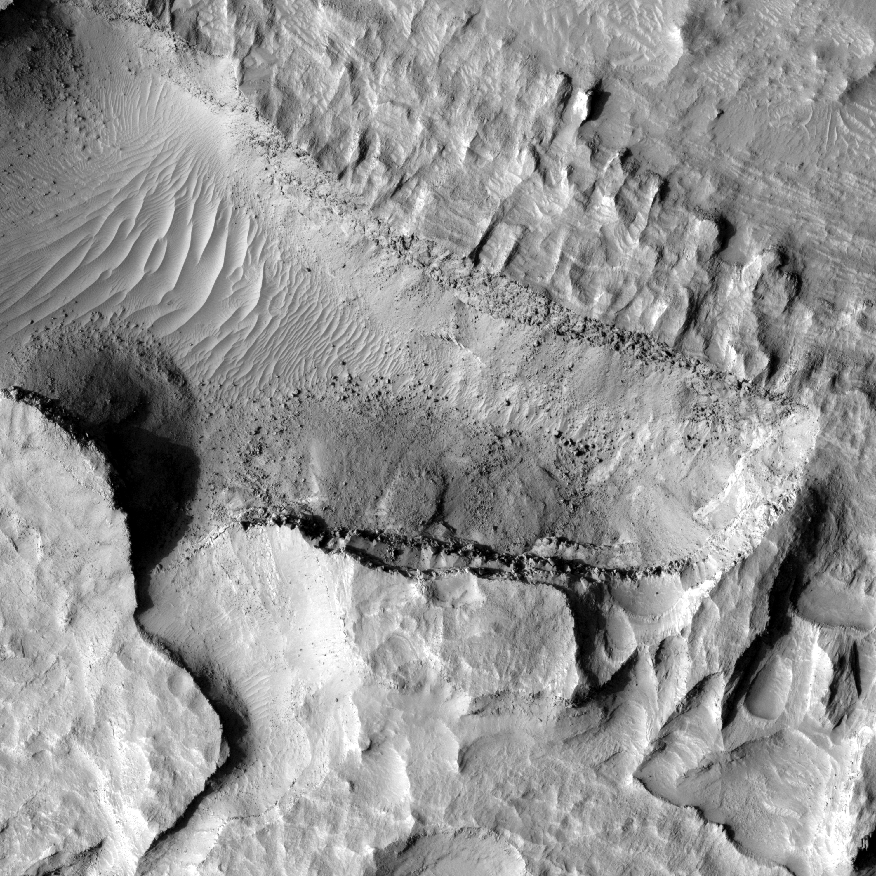
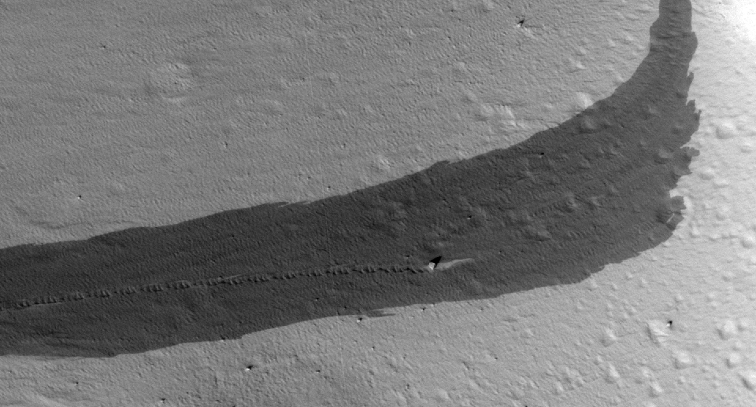
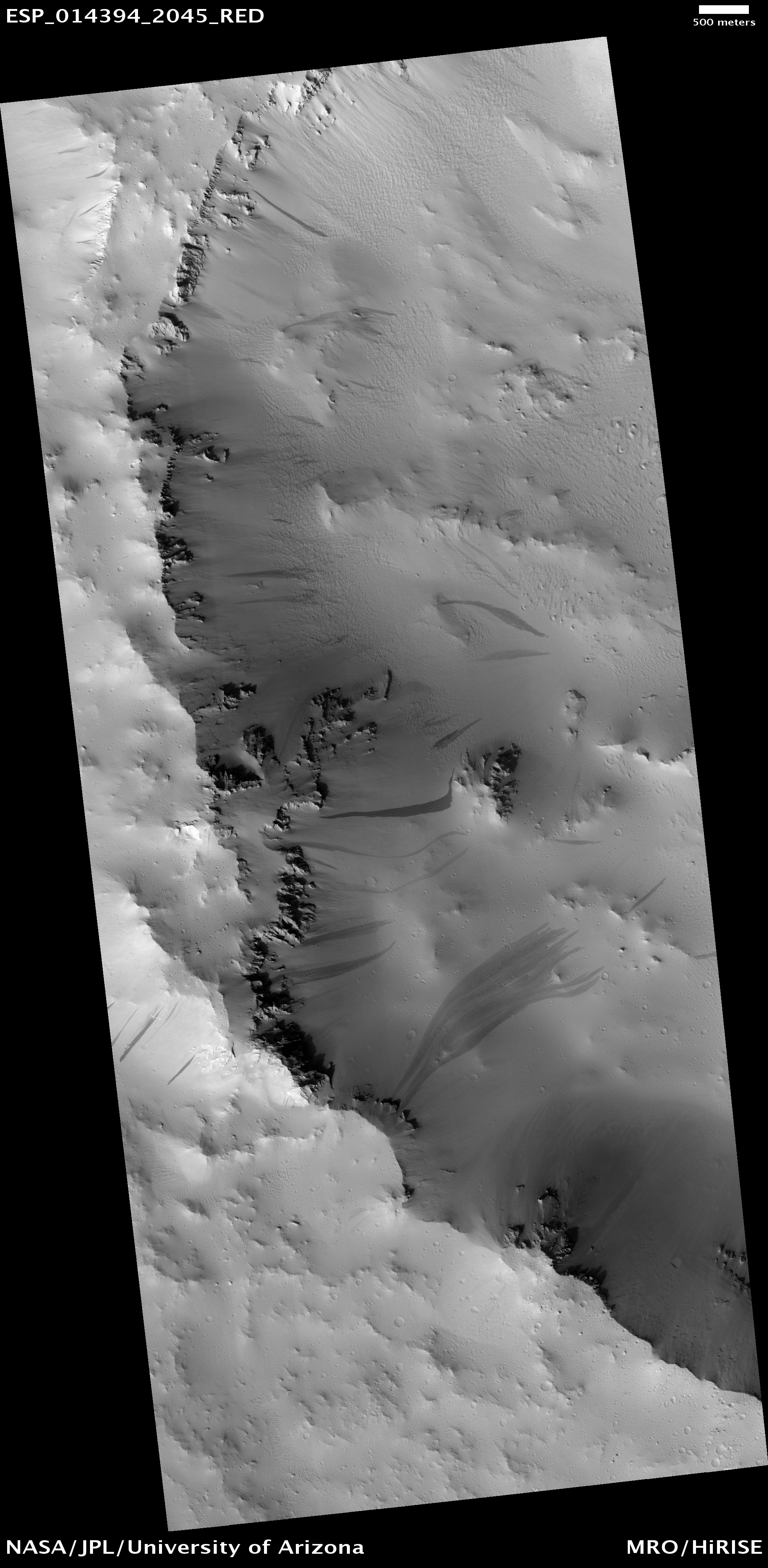
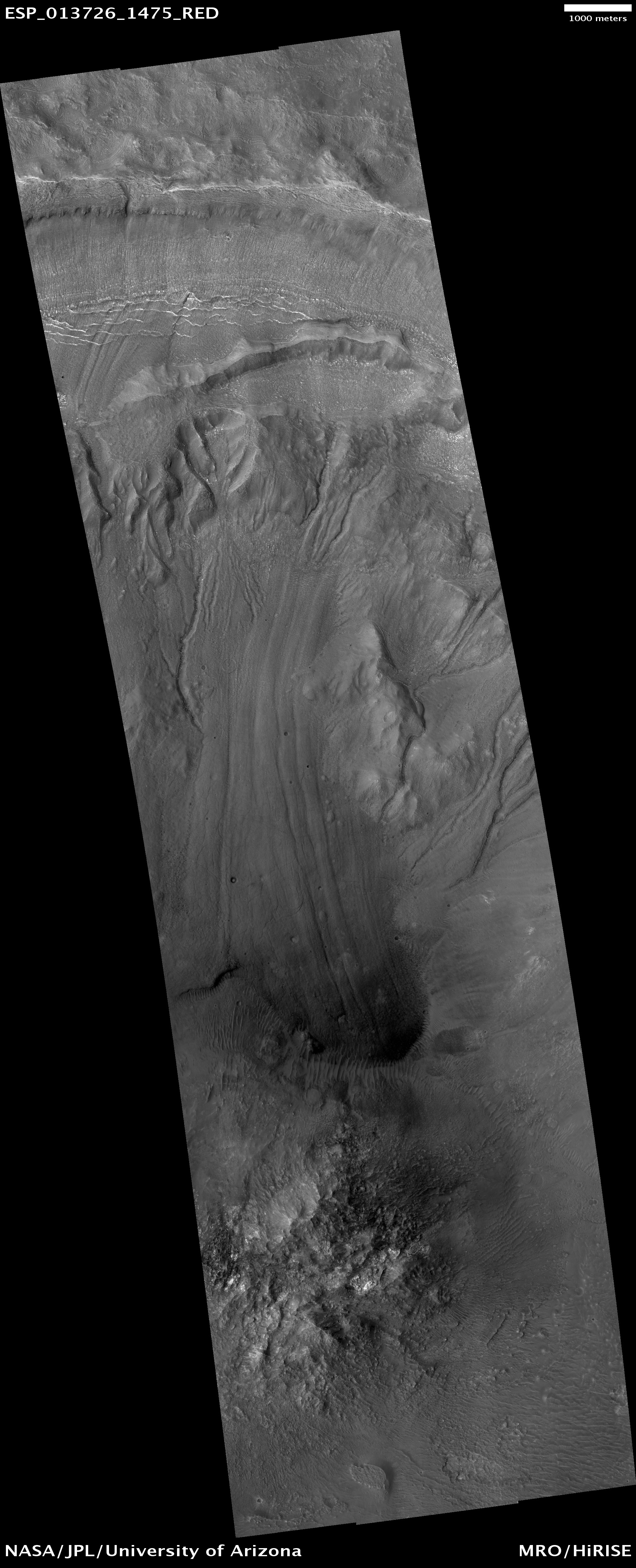
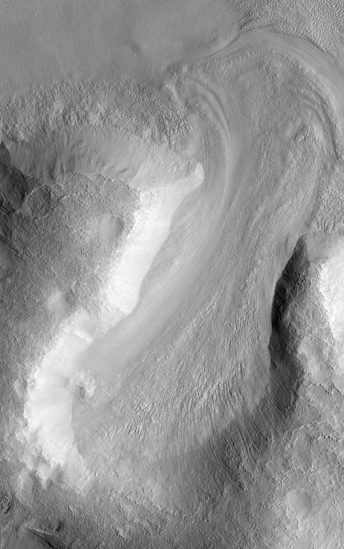
These pits formed through collapse above an underground void. The movement of rock along faults may have created this void deep underground.

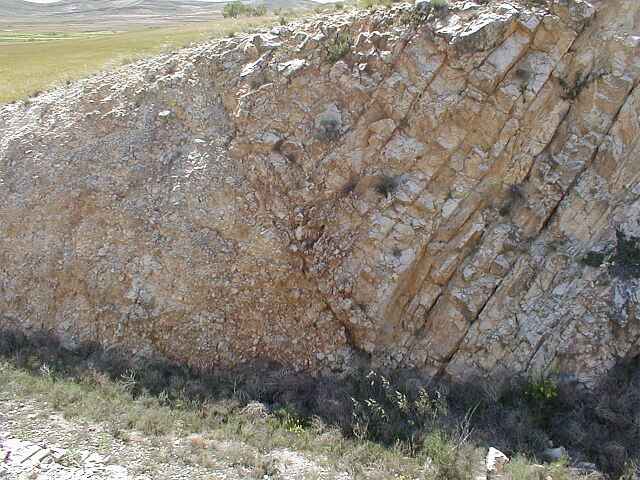
Faults are commonly thought of as planar cracks in the ground. In reality, faults have very rough surfaces that can create voids as the rocks slide along the fault. Alternatively, the movement of magma (molten rock) underground may have also created such underground voids. As magma moves underground, it pushes aside the bedrock, making an underground tunnel. This tunnel remains behind as the magma drains away and subsequent collapse can occur into it. A combination of processes may also result in pit crater formation, as faults are pre-made passageways for the magma to move underground.

There is much evidence of faulting in this scene. The series of stair-stepped cliffs are actually faults, with each cliff representing the approximate location of a fault. Thus it seems likely that faults played an important role in the formation of these pit craters.

The role of magma flow in the formation of these pit craters remains unknown. The presence of eruptive vents near these pits would be a clue to the past presence of magma. Such vents are not observed in this image, although the absence of these vents does not rule out magma. Magma does not always erupt at the surface and can remain entirely underground.

Photo credit: NASA/JPL/University of Arizona

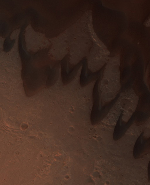
Note: Tractus Catena is a very long series of pit caves located in the region between Ascraeus Mons to the southwest and Alba Mons to the northwest.

Sunday, May 30, 2010

Nanedi Valles


(Today's caption by ASU stinks once more, so here's my own:)

Above is a portion of Nanedi Valles, an 800-kilometer canyon that is located in Xanthe Terra and flows roughly to the northeast. Nanedi Valles is located to the west of the much bigger and more impressive Shalbatana Vallis. As can be seen in the image above, Nanedi Valles is characterized by being very sinuous; it also has only a few short branches, which are not seen in the photo. The canyon walls tend to be steep, while the floor is relatively flat. How Nanedi Valles formed is unclear. Competing theories include sapping (erosion caused by ground-water outflow), a flow of liquid beneath an ice cover or a collapse of the surface in association with liquid flow.

This photo was taken by THEMIS on board the 2001 Mars Odyssey spacecraft.

Photo credit: NASA/JPL/Arizona State University

Planum Boreum


This image, combining data from two instruments aboard NASA's Mars Global Surveyor, depicts an orbital view of the north polar region of Mars.

The ice-rich polar cap (the quasi-circular white area at center) is approximately 1,000 kilometers (621 miles) across. The white cap is riven with dark, spiral-shaped bands. These are deep troughs that are in shadow. They do not reflect sunlight as well or have more internal layers exposed. To the right of center, a large canyon, Chasma Boreale, almost bisects the ice cap. Chasma Boreale is about the length of the United States' famous Grand Canyon and up to 2 kilometers (1.2 miles) deep.

New findings from the shallow radar instrument aboard the Mars Reconnaissance Orbiter have revealed subsurface geology in this region, allowing scientists to reconstruct the formation process of the large chasm and spiral troughs (see PIA13164).

The image synthesizes topographic data from Mars Orbiter Laser Altimeter (MOLA) and images from the Mars Orbiter Camera (MOC).

Mars Global Surveyor, launched in 1996, operated longer at Mars than any other spacecraft in history. It went silent in November 2006, after gathering data at Mars for more than four times as long as originally planned.

Photo credit: NASA/JPL-Caltech/MSSS

Notes: For more information, please see NASA Orbiter Penetrates Mysteries of Martian Ice Cap

Saturday, May 29, 2010

Ius Chasma


Large landslide deposits dominate this VIS image of Ius Chasma. Dunes are visible at the bottom of the frame.

Photo credit: NASA/JPL/Arizona State University

A Cross-Sectional Radar View of Mars' North Polar Ice Cap


This image shows a cross-section of a portion of the north polar ice cap of Mars, derived from data acquired by the Mars Reconnaissance Orbiter's Shallow Radar (SHARAD), one of six instruments on the spacecraft.

The data depict the region's internal ice structure, with annotations describing different layers. The ice depicted in this graphic is approximately 2 kilometers (1.2 miles) thick and 250 kilometers (155 miles) across. White lines show reflection of the radar signal back to the spacecraft. Each line represents a place where a layer sits on top of another. Scientists study how thick the pancake-like layers are, where they bulge and how they tilt up or down to understand what the surface of the ice sheet was like in the past as each new layer was deposited.


Photo credit: NASA/JPL-Caltech/ASI/UT

Friday, May 28, 2010

Kasei Valles


This VIS image shows a small portion of the complex channel system, Kasei Valles. In this image secondary channeling has cut down deeper into the main channel.

Photo credit: NASA/JPL/Arizona State University

Eroding Crater Fill


This image shows the edge of a mound of sediments in the center of a large impact crater near Amenthes Planum.

The mound probably once filled much more of the crater, but it is now eroding away. A broad view shows several small plateaus which have likely been preserved by a relatively resistant cap layer, while other levels are exposed elsewhere.

The subimage highlighted here shows several types of layers exposed in a pit. These variations point to a relatively complex geologic history at this site. Some layers appear to be fracturing into boulders which roll downslope, while others appear relatively smooth. There are also variations in tone, from light to dark. This diversity may be due to different types of rock, as well as varying strength.

Images such as this one indicate that rocks formed on Mars in a variety of ways, and by careful analysis it may be possible to deduce some of the history that has produced the geology at this site.

Photo credit: NASA/JPL/University of Arizona

Note: Amenthes Planum is a dagger-shaped plain located to the southeast of Isidis Planitia.

Thursday, May 27, 2010

Wind Effects Near Amazonis Mensa


Located near Amazonis Mensa, this region of Mars has undergone erosion by wind. Long linear hills being created by the wind are called yardangs.

NASA/JPL/Arizona State University

Icy Impact


A thick (approximately 3 kilometer or about 2 mile) sequence of ice and dust, stacked like a layer cake, covers the south pole of Mars. Impact craters that form here experience slightly different processes of modification and degradation than those that form in rocky areas.

One example of such a process is sublimation. Most of the material that makes up an icy crater is volatile, meaning it can melt or sublimate (change directly from a solid to a gas) if heated. Sublimation is more common on Mars because of its thin, dry atmosphere. Crater walls facing the Sun receive more direct light than their surroundings, and are therefore more easily warmed. If the ice in the walls sublimates, the rim structure of the crater becomes degraded.

The impact crater in this image is roughly 900 meters (a little over 0.5 mile) across. The remaining raised rim of the crater is illuminated from the bottom right of the image, causing preferential heating of the interior of the rim structure. The ice appears thin here (more brown material is exposed), with an even thinner cover on the remaining exterior rim. This could be caused by a number of possibilities: perhaps the exterior wall is steeper than the interior wall, resulting in more direct exposure to sunlight, causing more efficient sublimation when the Sun shines on that wall.

Once ice begins to melt, darker dustier material is exposed. The darker material absorbs more heat than white ice (just like standing in the Sun wearing a black shirt makes you warmer than wearing a white shirt, which reflects the Sun's light), causing more and more ice to sublimate near the dark material. You can observe this process happening around the exterior crater wall in this HiRISE image.

Photo credit: NASA/JPL/University of Arizona

Wednesday, May 26, 2010

Eberswalde Crater Delta


The channel entering Eberswalde Crater has deposited a fan-shaped delta on the crater floor.

Photo credit: NASA/JPL/Arizona State University

Phoenix Lander after One Mars Year


The latest HiRISE image appears to show that a solar panel of the Phoenix lander has collapsed.

HiRISE has been imaging the terrain around the landing site, including the Phoenix spacecraft itself, to study the seasonal changes that occur around this region. Phoenix landed on 25 May 2008 at 68 degrees North latitude during the Martian summer.

In the winter at this latitude the atmosphere and surface get so cold that carbon dioxide, which accounts for 95 percent of the gas in the Martian atmosphere, forms a frost on the surface as much as several decimeters (one or more feet) thick. This frost, also known as dry ice, blankets the entire northern landscape each winter, including any spacecraft that might be on the surface. In spring and summer this frost dissipates by sublimation, the process in which a solid ice evaporates directly to a gas without any melting.

This new image of the Phoenix landing site is a close match to the season and illumination and viewing angles of some of the first HiRISE images acquired after the successful landing on 25 May 2008. By comparison to PSP_009290_2485 (and other images acquired in 2008) we can see that the lander, heat shield, and backshell-plus-parachute are now covered by dust, so they lack the distinctive colors of the hardware or the surfaces where the pre-landing dust was disturbed.

But if the lander is structurally intact, it should cast the same shadows. While that is indeed the case for the shadow cast by the backshell (which came to rest on its side), that does not appear to be the case for the lander.

The 2008 lander images showed a very bright spot (from specular reflections) with relatively blue spots on either side corresponding to the clean circular solar panels. The shadows cast by the lander body and solar panels consists of three overlapping dark circles (see simulated image), although the specular reflection hides part of the shadows and the three shadows will merge together to a degree in actual HiRISE images.

In this observation, with illumination and viewing angles within 1 degree of those in PSP_009290_2485, we see a dark shadow that could be that of the lander body and eastern solar panel, but no shadow from the western solar panel is apparent. Because the specular reflection is no longer present on the dusty lander, the 2010 image should provide a better view of the of the west-array shadow, but it is absent.

The solar arrays were not designed to withstand significant loads such as that from perhaps 30 centimeters (1 foot) of carbon dioxide frost, so our interpretation is that this panel has collapsed. It is currently not know how much of the seasonal frost forms as falling dry-ice snow, in contrast to direct condensation of a surface ice which on Earth would be known as a hoar frost. Thus it is [not] known how fluffy or dense this frost might be.

The comparison of these images also reveals why it has proven so difficult to locate the failed 1999 Mars Polar Lander (MPL). HiRISE searched for MPL after several southern winters had passed, so the hardware likely appears similar to the Phoenix hardware in 2010. The bright parachute is completely hidden by dust and the bright specular reflections are gone. The lander appears as an unusually large shadow from what might appear to be a boulder that is undersized relative to the shadow. The backshell has an unusual shape for a boulder, because it came to rest on its side. There is still a dark spot where the heat shield came to rest, but the bounce mark to the west is not apparent. In other words, in 2010 there are only very subtle hints of the Phoenix landing event in HiRISE images.

If that's all we had to go by, if Phoenix had failed and we were searching for it over a large landing ellipse after a polar winter had come and gone, it would be extremely difficult to deduce that this was the landing site or to understand if the landing itself had succeeded.

Text credit: NASA/JPL/University of Arizona
Photo credit: NASA/JPL/University of Arizona

Note: For more information, read the NASA press release Phoenix Mars Lander is Silent, New Image Shows Damage

Tuesday, May 25, 2010

Martian Barchans


Barchan dunes are common on both Earth and Mars. These dunes are very distinctive in shape, and are important because they can tell scientists about the environment in which they formed.

Barchans form in wind regimes that blow in one dominant direction. The ridged arcs of sand that define the barchan dunes end in horns that point downwind. Sand is transported up the broad, relatively shallow windward slopes and once it overtops the dune crest, the sand falls down a shorter steeper slope between the horns, known as the slip face. Over time, the barchans migrate downwind, following their horns. (The subimage refers to the non-map projected version of the image.)

This HiRISE image shows an example of several barchans merging to form an even larger barchan dune. This can happen through a variety of circumstances, such as when smaller, faster dunes collide with larger, slower-moving dunes that absorb them, resulting in single, larger dunes. The distance between the merging horns of the large dune in this highlighted region is a little over 500 meters (about 1600 feet).

Photo credit: NASA/JPL/University of Arizona

Note: This image is located in an unnamed impact crater in Ophir Planum, located halfway between Mutch Crater and Ganges Chasma.

Monday, May 24, 2010

Candor Chasma


The ridge features at the top of this VIS image are called spurs. Spurs and gullies form the cliff sides of the Vallis Marineris chasmata. Sand dunes can be seen at the bottom of the image. Dunes are a common feature on the floors of the chasmata.

Photo credit: NASA/JPL/Arizona State University

Bouncing Boulder Blocks a Slope Streak


A boulder track is visible in the center of this subimage.

The track formed on the sloping wall of an impact crater when a rock bounced or rolled downhill leaving behind marks on the surface. In the full image, you can see its whole path, starting from a cliff to the east, from which it presumably originated. The boulder itself is visible as a brighter rock in the middle of the dark slope streak, where it finally came to a halt.

Slope streaks begin at a point, and it only takes a small disturbance at that point to initiate the streak, such as a dust devil or an impact crater. We have seen these streaks appear, so this is an ongoing process on Mars. The streaks tend to start out dark and fade as they get older; we have even seen some that are lighter in color than their surroundings. Scientists think these are caused by dry avalanches of dust or sand falling downhill, revealing darker material underneath. The streaks are very shallow and don't appear to disturb pre-existing features on the surface, like ripples, or in this case, the boulder tracks. This case is particularly interesting because the slope streak appears to have flowed around the boulder, leaving a patch of brighter material undisturbed in the lee of the rock. From this relationship, you can tell that the boulder must have fallen before the slope streak formed.

For scale, the boulder is about 6 meters (approximately 20 feet) across, and the dark streak is about 125 meters (approximately 400 feet) wide at its widest point.

Photo credit: NASA/JPL/University of Arizona

Note: This crater is located on the Tharsis bulge, northwest of Olympus Mons.

Sunday, May 23, 2010

Cerberus Fossae


The fractures in this VIS image are part of Cerberus Fossae.

Photo credit: NASA/JPL/Arizona State University

South Polar Carbon Dioxide Ice Cap


This HiRISE image is of a portion of Mars' south polar residual ice cap. Like Earth, Mars has concentrations of water ice at both poles.

Because Mars is so much colder, however, the seasonal ice that gets deposited at high latitudes in the winter and is removed in the spring (generally analogous to winter-time snow on Earth) is actually carbon dioxide ice. Around the south pole there are areas of this carbon dioxide ice that do not disappear every spring, but rather survive winter after winter. This persistent carbon dioxide ice is called the south polar residual cap, and is what we are looking at in this HiRISE image.

Relatively high-standing smooth material is broken up by semi-circular depressions and linear, branching troughs that make a pattern resembling those of your fingerprints. The high-standing areas are thicknesses of several meters of carbon dioxide ice. The depressions and troughs are thought to be caused by the removal of carbon dioxide ice by sublimation (the change of a material from solid directly to gas). HiRISE is observing this carbon dioxide terrain to try to determine how these patterns develop and how fast the depressions and troughs grow.

While the south polar residual cap as a whole is present every year, there are certainly changes taking place within it. With the high resolution of HiRISE, we intend to measure the amount of expansion of the depressions over multiple Mars years. Knowing the amount of carbon dioxide removed can give us an idea of the atmospheric, weather, and climate conditions over the course of a year.

In addition, looking for where carbon dioxide ice might be being deposited on top of this terrain may help us understand if there is any net loss or accumulation of the carbon-dioxide ice over time, which would be a good indicator of whether Mars' climate is in the process of changing or not.

Photo credit: NASA/JPL/University of Arizona

Saturday, May 22, 2010

Dunes in Moreux Crater


This image shows numerous sand dunes on the floor of Moreux Crater. Moreux is a large crater located in northern Arabia Terra, just to the south of Protonilus Mensae, and is named after the French astronomer, Theophile Moreux (1867-1954).

Photo image: NASA/JPL/Arizona State University

Megabreccia in Toro Crater


This false color image covers the western half of the central peak of Toro Crater, a 42 kilometer diameter crater in Syrtis Major.

The subimage shows a close-up of one of the features that make Toro Crater a great target for HiRISE images: colorful patches of megabreccia. Breccia is a mixture of chunks of rock (clasts) that have been broken by an energetic geologic event, such as a landslide or crater-forming impact, that are then cemented together in a finer grained material. Megabreccia features very large clasts that are big enough for HiRISE to see on the surface - some even larger than 30 feet across. In this 200 meter (about 1/8 of a mile) diameter exposure of megabreccia, clasts of various colors (indicating different kinds of rocks) and sizes have been exposed in the uplifted central peak of Toro Crater.

Scientists think that megabreccia may have formed early in Mars' history during a period of frequent impact crater formation. These early rocks were then covered by younger rock layers. HiRISE frequently targets the central peaks of craters, because these features tend to bring up rocks like these megabreccia that are usually buried under the surface.

So far, HiRISE has found megabreccia in more than a hundred places on Mars. In many of these locations, CRISM has identified clays in the material cementing the clasts together, providing yet another motivation for the study of megabreccia.

HiRISE first imaged Toro Crater (in PSP_005842_1970) because CRISM detected hydrated minerals, like clays, on the floor. The instruments of MRO often observe the same areas of Mars simultaneously through a process known as "ride-alongs." That earlier image was so interesting that HiRISE has since acquired a number of images over the crater (PSP_006910_1975, PSP_007266_1970, ESP_011538_1970).

Photo credit: NASA/JPL/University of Arizona

Note: Toro Crater is located to the west of Isidis Planitia.

Friday, May 21, 2010

Sandy Ganges Chasma


Sand is abundant of this portion of the floor of Ganges Chasma.

Photo credit: NASA/JPL/Arizona State University

Opportunity Looks Back


NASA's Mars Exploration Rover Opportunity used its navigation camera for this northward view of tracks the rover left on a drive from one energy-favorable position on the northern end of a sand ripple to another. The rover team calls this strategy hopping from lily pad to lily pad.

Opportunity took this image on the 2,235th Martian day, or sol, of the rover's mission on Mars (May 8, 2010). The tracks are from a 14.87-meter (49-foot) drive southward on the preceding sol. Mars' southern hemisphere was in the minimal sunshine period close to the winter solstice, which occurred May 13, 2010 (Universal Time).

Making progress on Opportunity's long trek to Endeavour Crater remains the extended mission's priority, but the amount of solar energy is so limited at this season that Opportunity needs to rest to recharge batteries for sols between drives. The sun crosses the sky low in the north. Choosing end points for drives that give a favorable northward tilt for the rover's solar panels makes the recharging go faster. The sand ripples in this part of Meridiani Planum are aligned generally north-south, so this means ending drives on the northern ends of the ripples.

Opportunity took this image from the northern end of a ripple that is not visible in the image.

For scale, the distance between the parallel wheel tracks is about 1 meter (3 feet).

Photo credit: NASA/JPL-Caltech

Special Note: This is the 200th post for Areology!

Thursday, May 20, 2010

Cydonia Mensae


Today's featured image from the JPL Photojournal is somewhat unusual in that the caption normally included from the THEMIS gallery webpage is missing, and the actual caption at the THEMIS website is pathetically lame ("This fractured region is part of Cydonai [sic] Mensae."). So I thought I'd write my own caption for this photo.

This photo is taken from the Cydonia Mensae region of Mars, which is a transitional area located between Arabia Terra to the south and Acidalia Planitia to the north. Mensae (the plural form of Mensa) is the word used by planetary geologists for mesas; however, in this photo, what we see are a number of interlocking channels. Any water that had flowed through these channels would have flowed north, toward the top of this photo.

Incidentally, the Cydonia region is home of the famous "Face on Mars," which is located to the northeast of this location.

Photo credit: NASA/JPL/Arizona State University

Gullies and Flow Features on Crater Wall


This HiRISE image shows a sample of the variety and complexity of processes that may occur on the walls of Martian craters, well after the impact crater formed.

At the very top of the image is the high crater rim; at the bottom of the image is the crater's central peak - a dome of material rising above the surrounding crater floor uplifted during the impact event.

Reaching down the walls of the crater are windy and crooked troughs, or gullies. Some of these gullies may have formed with the help of liquid water, melted from ice or snowpack on the crater walls or from groundwater within the walls. Also notable is the long tongue-like lobe stretching down the middle of the image, with a darker, rounded snout, and prominent parallel grooves on its surface. These characteristics, together with faint cracks on its surface, suggest that this lobe may have formed by movement of ice-rich material from up on the crater wall down to the crater floor.

Because surface features on this lobe, as well as most gullies, do not appear sharp and pristine, and wind-blown dunes have blown up on the front snout of the lobe, and because there are several small craters on the lobe's surface, the movement of ice-rich material, and possibly water, have probably not occurred very recently.

This image forms a stereo pair with ESP_013871_1475.

Photo credit: NASA/JPL/University of Arizona

Note: This crater is located in the Promethei Terra region of Mars, which is located to the northeast of Hellas Planitia.

Wednesday, May 19, 2010

North Polar Dunes


Dunes are common at both poles of Mars. These northern pole dunes are still covered in frost, as it is early springtime when this image was acquired.

Photo credit: NASA/JPL/Arizona State University

New Craters on Mars


Although most of the craters HiRISE usually images are ancient, impact cratering is an ongoing process on the Martian surface.

While very large craters are rare, smaller ones with diameters of a few meters form on timescales rapid enough for Mars missions to confirm the presence of a new crater. Data from the Mars Orbiter Camera (MOC) on the (now defunct) Mars Global Surveyor, the Context Camera (CTX) on MRO, and HiRISE have dated craters to within a few years or even months, based on repeat images that show no craters in the earlier image and craters present in the later image.

Most of the new craters identified by CTX and HiRISE have been located in Mars' dustiest areas, where a new impact will scour dust from the surface and reveal darker underlying rock. This color difference makes the craters easier to spot. Other, less dusty areas of Mars are certainly being bombarded as well, but the size of the craters makes them difficult to detect without stark color contrasts. Once a new dark spot has been identified by CTX, HiRISE will take a follow-up image to confirm that the dark spots are in fact impact craters.

Many of the newest craters are part of a crater cluster, like this one. This cluster is about 350 meters (almost a quarter mile) across at its longest, and the largest crater in the image is 5 meters (16 feet) in diameter. These clusters likely result from breaking up of the impactor before it strikes the surface. How widely dispersed the craters are depends on the strength and density of the impactor. Scientists can study these clusters to learn more about the object that created them.

Photo credit: NASA/JPL/University of Arizona

Note: These impact craters are located on the Tharsis bulge west of Pavonis Mons.

Tuesday, May 18, 2010

Syrtis Planum Landslide


This landslide deposit is located in an unnamed crater in Syrtis Planum.

Photo credit: NASA/JPL/Arizona State University

Note: I rather like this picture. The trail of the landslide is very clearly defined, with the high walls of regolith along the two sides. As for that knob of dirt and/or rock jutting out along the side of the crater, I thought at first that that was a second landslide deposit; however, now, I think it's part of the crater wall that didn't succumb to the force of the Martian soil that did fall.

Gullies on the Northwest Rim of Hale Crater


This image covers part of the northwest rim of Hale Crater. Gullies have formed down the interior rim of the crater in this location.

While the origin of these gullies is not clear, some have attributes similar to their counterparts on the Earth that result from flowing water. These include upper regions where gully tributaries have eroded into the source rocks, sinuous or "snake-like" channel middle reaches, and down slope regions where gullies distribute and terminate in deposits of sediment and debris.

Bright material deposits are evident along the walls of some gullies. These deposits might be the result of transport or exposure of finer-grained sediments, variations in the brightness of dust or materials, or the presence of ice or fresh deposits within the gullies.

Hale is an elliptical-shaped crater, approximately 150 by 125 kilometers, and is centered at 35.7 degrees South, 323.4 degrees East on Mars, just north of Argyre Basin.

Photo credit: NASA/JPL/University of Arizona

Monday, May 17, 2010

Dunes in Herschel Crater


The dunes in this VIS image are located on the floor of Herschel Crater.

Photo credit: NASA/JPL/Arizona State University

Megabreccia in the Central Uplift of Stokes Crater


Stokes is a large, approximately 60 kilometer diameter (38 miles) impact crater located in the Northern lowland plains of Mars.

Craters this large invariably have a central structural uplift, which form mountain peaks in or near the center of the crater. The Northern plains are largely covered by lavas and sediments, but craters such as Stokes allow us to observe the otherwise buried bedrock, exposed within its central uplift.

The first subimage shows a wide variety of colors and textures in a jumbled, fragmental pattern, i.e. "megabreccia." In the stereo anaglyph we can see that many of the fragmental blocks "stick out," indicating that they are more resistant to erosion than the the surrounding finer-grained material between the blocks. There is also an abundance of dark sand dunes and other smaller aeolian (wind-driven) bedforms on top of the area of exposed bedrock.

Megabreccia, consisting of very large fragments of pre-existing bedrock, is created by energetic processes, but especially by impact events on Mars. Although megabreccia deposits can coat central uplifts, it may not have been the Stokes impact that made this megabreccia.

The formation of a crater's central uplift does not commonly break up and jumble the deep bedrock. So if these megabreccias are exposures of the deep bedrock brought up to the surface by the central uplift, and are not merely deposits draped on the central uplift, then it is most likely that these megabreccias were created by much larger and older basin-forming impacts that now lie buried beneath the surface.

With the aid of high-resolution images, and especially the 3D anaglyphs, we hope to decipher whether the materials observed in the central uplift were formed by the host crater or prior to the formation of that crater. Either way, crater central uplifts can provide windows into the deepest and oldest geologic history of Mars. For example, if there was a very ancient ocean in the Northern lowlands, these rocks could include deposits from that ocean.

NOTE
This pair of images (also see ESP_016980_2360) was targeted to acquire stereo coverage of the Eastern slopes of the central uplift (see PSP_09332_2360 for an adjacent area).

Photo credit: NASA/JPL/University of Arizona

Sunday, May 16, 2010

Cerberus Fossae


This VIS image shows a small portion of the large fracture called Cerberus Fossae.

Photo credit: NASA/JPL/Arizona State University

Collapse!


This observation (forming a stereo pair with ESP_016538_2190) shows part of an unnamed crater whose fill material has collapsed.

This crater may have been filled with ice, then covered by sediments or lava. Later the ice was lost by melting or sublimation and the topmost layer of indurated material collapsed, forming the broken and bent layer seen today.

The original image description reads "Pristine channels in fractured materials on crater floor." That's because when the target suggestion was entered (by me), I thought there were some narrow dark curving channels from a quick examination of MOC image R1601469. This could indicate geologically-recent flow of water, the stuff we're supposed to follow.

However, the HiRISE images, especially viewed in stereo, show that these narrow dark features are actually the steep edges of escarpments created by the collapse. So beware of believing HiRISE image descriptions! Sometimes our initial impressions collapse.

Photo credit: NASA/JPL/University of Arizona

Note: This crater is located in Arabia Terra, just south of the "shore" of Acidalia Planitia to the north. It lies roughly halfway between the craters Sklodowska (named after the Nobel Prize-winning scientist, Madam Marie Sklodowska-Curie (Sklodowska being her maiden name) to the southwest and Semeykin to the northeast.

Saturday, May 15, 2010

Utopia Planitia


This image of central Utopia Planitia shows some dust devil tracks. These features are common in this region of Mars.

Photo credit: NASA/JPL/Arizona State University

Geezer Gullies at Tempe Terra


This image shows gullies in the walls of a large impact crater in Tempe Terra. These gullies look quite older than other gullies imaged by HiRISE elsewhere on Mars.

We cannot tell what is the absolute age of these "geezer gullies" (that is, how long ago they formed), because actual rock samples would have to be analyzed with radiometric dating techniques to get that information. However, this image indicates that they have been inactive for a long time.

This subimage shows some of these gullies in detail. The walls of these venerable gullies have gentle, smooth-looking slopes which contrast with the tall and steep walls of younger gullies. Their floor is even and lacks sharply incised channels that would indicate recent activity. The weathering processes required to produce such a smooth landscape are very slow and thus must have acted during a long period of time.

The gullies appear cut by long fractures that criss-cross the crater's walls, and pockmarked by numerous impact craters which are just a few meters (yards) in diameter. According to cross-cutting relationships (used by geologists, archaeologists, and other detective-types to establish relative ages), this means that the gullies must be older than the fractures and small craters. Crater counting is a valuable technique used to estimate the relative age of terrains on Mars and other planetary surfaces; the more time a terrain has been exposed at the surface, the more craters it has accumulated.

The color and brightness of the gullies is similar to that of their surroundings, probably due to a veneer of undisturbed, homogeneous dust mantling the entire region.

All these lines of evidence indicate that these gullies have remained inactive for a long period of time. Why are they "dormant," while other Martian gullies appear to show recent activity? Studying both old and young gullies will help us learn more about their processes of formation (erosion from seepage of subsurface water? melting of ground ice or surface snow? dry landslides?). Their differences will tell us how these processes (many of which depend on Mars' climate) may have evolved through time.

Photo credit: NASA/JPL/University of Arizona

Friday, May 14, 2010

Acheron Fossae


Acheron Fossae is a dissected region of rugged terrain located north of Olympus Mons. Numerous channels are visible in this image.

Photo credit: NASA/JPL/Arizona State University

Note:Channels? Or gullies? The context map on the catalog page clearly shows that the terrain on the left is a mountain ridge that slopes downhill to the right. The fossae look like gullies to me.

Viscous Flow in Protonilus Mensae


This subimage highlights a feature that resembles a terrestrial glacier, indicating that material has viscously flowed at this location. It appears that water ice has collected at the head of the valley (at bottom), allowing glacier-like flow toward the top of the subimage.

At the top right of the subimage, the flow appears to have slowed down and stopped, forming ridges perpendicular to the flow direction. Similar features are observed on terrestrial glaciers, but Martian examples are not as bright as many on Earth. The Martian glaciers appear to be covered by dust and other debris, hiding the ice below. Such debris-rich flows on Earth are called "rock glaciers" and may be good analogs for the flow seen here.

Photo credit: NASA/JPL/University of Arizona

Note: This photo was taken in the Protonilus Mensae region, which is located between the northeastern-most tip of Arabia Terra and Vastitas Borealis. The location of this glacier is roughly halfway between the craters of Moreux and Renaudot, being slightly closer to Renaudot.

Thursday, May 13, 2010

Wind Effects South of Olympus Mons


This VIS image is located south of Olympus Mons and east of Gordii Dorsum, in a heavily wind eroded region. The winds are predominately east/west in this area.

Photo credit: NASA/JPL/Arizona State University

Star Dunes in Crater in Tyrrhena Terra


An amazing aspect of Mars that is captured in many HiRISE images is geologic diversity within a small area. This image, of a crater in the Tyrrhena Terra region, was targeted to look at the geologic aspects of possible clays detected with the CRISM instrument.

Fortuitously, a beautiful set of star dunes are visible on the western edge of a small crater within the larger target crater (this smaller crater is in the southwest [lower left] of the image). Star dunes form when sand is blown by winds coming from multiple directions, which is common in craters. This results in intersecting dunes, forming a polygonal, or "star" pattern.

Here we show two zooms of the star dunes. The closest zoom (at right) shows lumpy deposits of sand in the interior of the star patterns, probably resulting from avalanches off of the dune slopes. The dune sands are most likely made of basalt, a common volcanic rock. The possible clay-bearing material is probably within the surrounding bedrock.

Photo credit: NASA/JPL/University of Arizona

Wednesday, May 12, 2010

Northern Terra Sabaea


Northern Terra Sabaea is dissected by numerous fractures and channels.

Photo credit: NASA/JPL/Arizona State University

Icy Northern Dunes


Like Earth, Mars has seasonal polar caps that grow in the winter and retreat in the spring, but on Mars the seasonal caps are composed primarily of carbon dioxide (dry ice). Carbon dioxide is the major component of the Martian atmosphere, and a significant fraction of the mass of the atmosphere is cycled through the seasonal caps every year.

This image shows sand dunes that are mostly covered by seasonal frost/ice in the northern spring. When the springtime sun shines on the ice, some of it penetrates to the base of the ice and warms the dark sand dune surface below. The warm sand evaporates the carbon dioxide ice from below, building gas pressure that apparently breaks the ice and carries sand to the surface as the pressure is released. The sand then cascades down the surface of the ice, forming the streaks seen in this image.

Photo image: NASA/JPL/University of Arizona

Notes: These sand dunes are located in the Vastitas Borealis, just south of the Planum Boreum. For the "streaks" link above, I chose to link to "Avalanches" as opposed to dark slope streaks, the reason being that, while the streaks of sand upon the ice are somewhat reminiscent of slope streaks, they are probably more similar to a very small scale avalanche of sand cascading down the ice. Dark slope streaks are formed when a small avalanche of bright dust and sand reveals a darker-colored substrate underneath; however, that is not the case here. Here, the opposite is happening, where dark sand is covering up the lighter-colored ice.

Tuesday, May 11, 2010

Two Worlds, One Sun


While humans' lives unfolded on Earth, NASA's Mars Exploration Rover Opportunity paused in its southward trek and captured this photomosaic around 15:00 local Mars time on May 2, 2010. ... Dusty, reddish brown dunes stretch southward to the horizon along the rover's route ahead.

The "Two Worlds, One Sun" theme is a reference to the motto inscribed on the Pancam calibration target, seen on the back of the rover deck at the bottom of this view. The target is used to properly calibrate and color-balance the Pancam images, and with its artistically styled shadow post, or gnomon, it doubles as a sundial (also known as a "Marsdial") for educational purposes. (See PIA05018.)

This scene is a three-tall by one-wide mosaic of Pancam images taken through the camera's red (602 nanometer), green (530 nanometer) and blue (480 nanometer) filters. It has been calibrated and processed to approximate the colors that would be seen by humans if they could be present for this lovely Martian view. The camera took the images during the 2,229th Martian day, or sol, of Opportunity's mission on Mars.

Photo credit: NASA/JPL-Caltech/Cornell University