Sunday, August 28, 2011

Spider Channels Near the South Pole


This HiRISE image shows erosional features formed by seasonal frost near the south pole of Mars.

During the winter, high latitudes (near the pole) on Mars build up deposits of carbon dioxide frost that can be several feet thick. In the spring these sublimate and turn back into gas. The gas sublimating at the bottom of the frost can move the underlying dust and even erode channels in it.

These channels form a variety of structures; examples like those at this site have been nicknamed "spiders" because many channels converge, giving a many-armed, spidery appearance.

This observation forms a stereo pair with ESP_023117_0980, and HiRISE has produced an anaglyph.

Photo credit: NASA/JPL/University of Arizona

Saturday, August 27, 2011

Exposures of Layered Rocks in the Argyre Region


This observation shows great exposures of layered rocks in Argyre region. Could it be evidence for an ancient sea or lake?

The Argyre region, also known as the Agyre quadrangle by the USGS, is also home of the Argyre impact basin, which contains some ancient eroded terrains, as well as other impact craters that HiRISE has imaged: Green Crater, Galle Crater, and Charitum Montes.

This subimage from the color swath (approximately 1.2 kilometers across) shows some of the rocks and layers in greater and impressive detail. (Note: the subimage is not map-projected so North is approximately down.)

This is a stereo pair with ESP_014167_1300.

Photo credit: NASA/JPL/University of Arizona

Thursday, August 25, 2011

The View Across Endeavour Crater


NASA's Mars Exploration Rover Opportunity used its panoramic camera to capture this raw image looking across Endeavour crater during the rover's 2,686th Martian day, or sol, of work on Mars (August 14, 2011).

Opportunity had arrived at the western rim of 13-mile-diameter (21-kilometer-diameter) Endeavour crater five days earlier. The distant horizon in this image is a portion of the east-northeastern rim of Endeavour. The large rock on the left in the foreground, informally named "Tisdale 1," is about 30 inches (about 80 centimeters) tall. It is part of a group of rocks that appear to have been ejected by the excavation of Odyssey crater on the rim of Endeavour crater.

Photo credit: NASA/JPL-Caltech/Cornell/Arizona State University

Wednesday, August 24, 2011

Ice, Salt and Warm-Season Flows on Mars


This map of Mars shows relative locations of three types of findings related to salt or frozen water, plus a new type of finding that may be related to both salt and water.

Coloring of the map is coded to concentrations of shallow subsurface water ice found by the Gamma Ray Spectrometer - Neutron Spectrometer on NASA's Mars Odyssey orbiter. Blue, at high latitudes north and south, indicates higher concentrations of water ice (deduced from detection of hydrogen); orange designates lowest concentrations. Some hydrogen, possibly in the form of bound water, is close to the surface even at middle latitudes.

The white squares in the northern hemisphere mark locations of small fresh impact craters that exposed water ice close to the surface and validated the neutron spectrometer data. Observations of these fresh craters were made by the Context Camera and the High Resolution Imaging Science Experiment camera on NASA's Mars Reconnaissance Orbiter.

The red squares mark locations of putative deposits of chloride based on observations by the Thermal Emission Imaging System on Mars Odyssey. Such salt deposits could have resulted from evaporation of salty water.

The blue squares mark locations of a type of feature reported in August 2011 based on sequences of observations by the High Resolution Imaging Science Experiment. The observations show relatively dark features appearing and incrementally growing down slopes during warm seasons. Researchers hypothesize that these features may result from action of briny water.

Map credit: NASA/JPL-Caltech/ASU/UA/LANL/MSSS

Tuesday, August 23, 2011

Pitted Materials in Bakhuysen Crater


Large impact craters often have pits on their floors. Some of these (with raised rims) are later impacts, but some are thought to originate immediately after the crater forms when slurries of molten and broken rocks occupy the crater floor.

Bakhuysen Crater, located in Noachis Terra, is thought to be the largest crater that possesses (and has preserved) these pitted materials.

This is a stereo pair with ESP_020731_1570.

Photo credit: NASA/JPL/University of Arizona

Monday, August 22, 2011

Hematite in Capri Chasma


Coarsely crystalline gray hematite is an iron oxide (Fe2O3) initially discovered from orbit by the instrument TES (Thermal Emission Spectrometer). TES has detected gray hematite in this area of Capri Chasma, one of several large depressions that make up the Valles Marineris canyon system.

This HiRISE image shows light-toned units beneath darker mantles. At the Opportunity landing site in Meridiani Planum, the same gray hematite is found in millimeter size globules that have weathered out of the sulfate outcrop and become concentrated along upper soils.

It is likely that the same scenario is taking place here in Capri with the hematite grains forming in the light-toned sulfates and then eroding out and concentrating in the darker mantle soils.

Photo credit: NASA/JPL/University of Arizona

Sunday, August 21, 2011

Frane Nella Valles Marineris


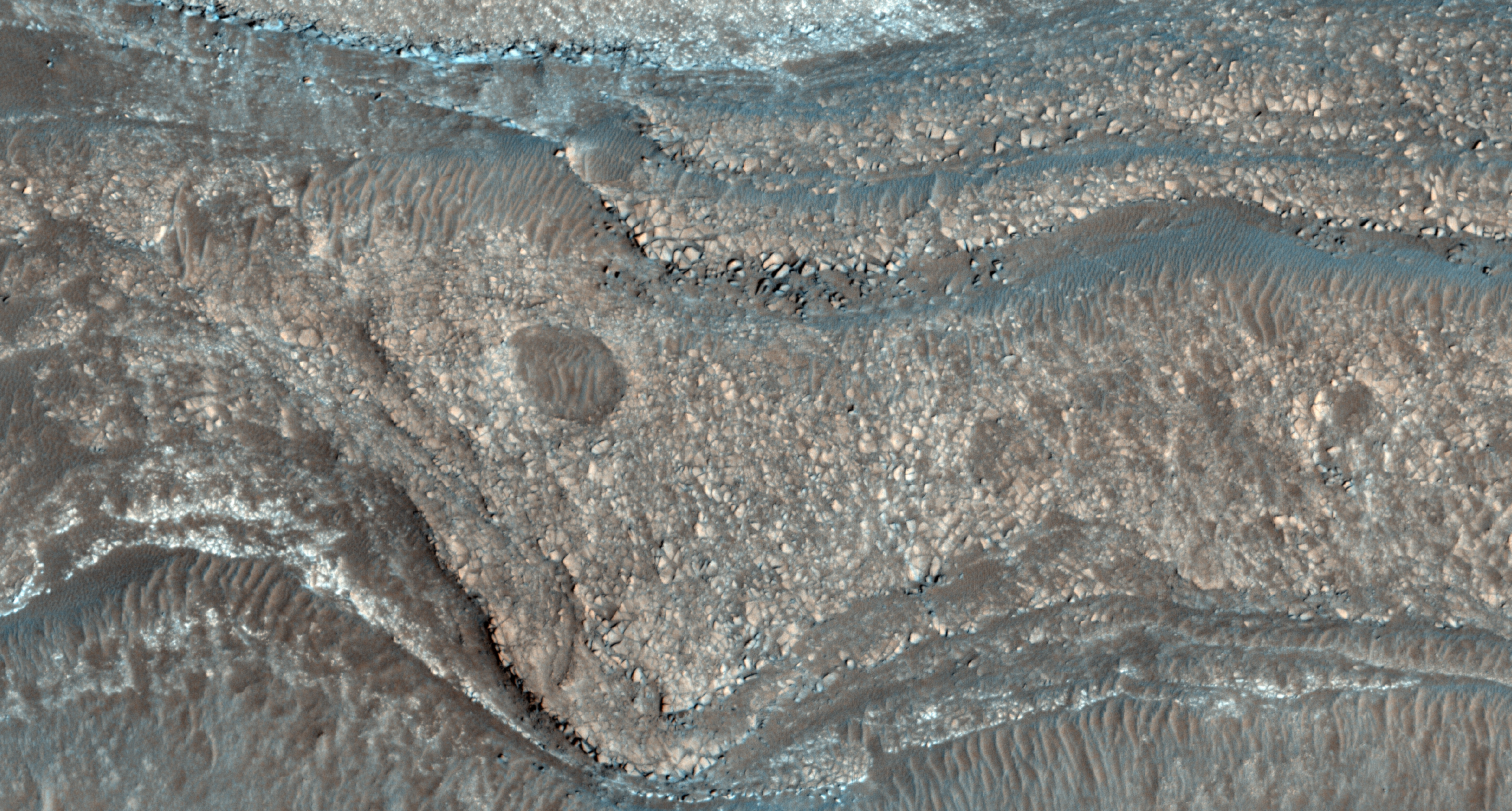
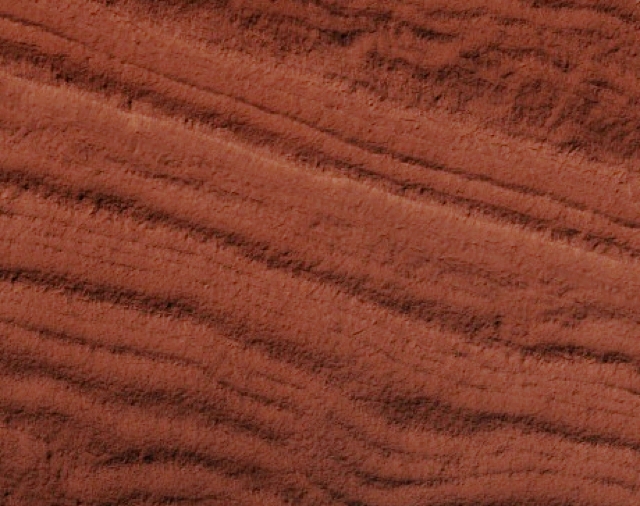
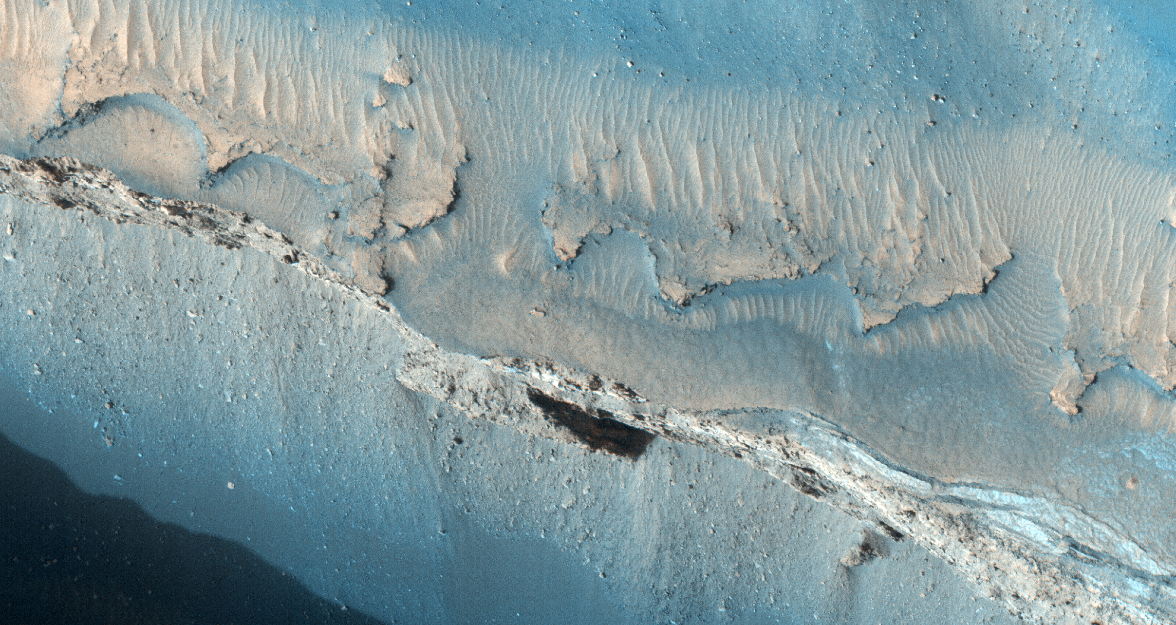
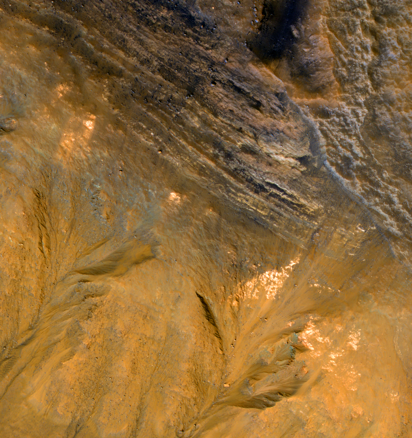
La Valles Marineris è il più grande sistema di canyon del sistema solare. Sovrapposta ad una mappa degli Stati Uniti, si estenderebbe da Los Angeles a Washington, D.C., per circa 4.000 chilometri (due volte la distanza tra Roma e Londra) ! L’ immagine qui presentata mostra perciò solo una piccolissima parte dell’ intero sistema.

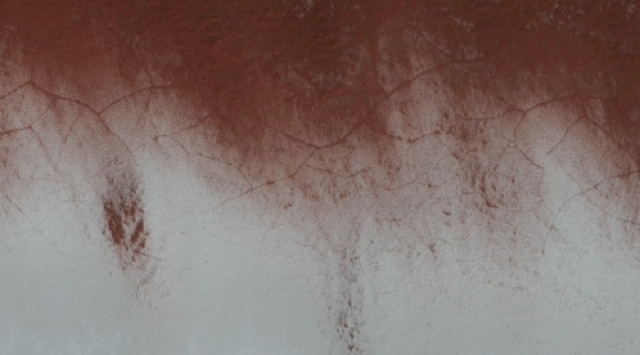
Questa osservazione ci mostra delle frane (fenomeni chiamati anche “dispersioni di massa”) che hanno assunto l’ aspetto di gole sulle pareti interne a strati della Valles Marineris. Si possono vedere anche nicchie e canali, come nell’ immagine PSP_004396_1675. Purtroppo la qualità di quest’ ultima immagine è molto scarsa a causa di una tempesta di sabbia e polvere in corso al momento dello scatto, per cui una futura, nuova ripresa della zona ci potrà fornire ulteriori informazioni di dettaglio sulla forma e sulle dimensioni delle formazioni qui presenti.

Photo credit: NASA/JPL/L'Università dell’Arizona

Note: The HiRise team writes captions to their photos in languages other than English. The above caption, for example, is in Italian. Below is the English translation, a la Google Translate. (Unfortunately, the quality of the translation is not quite as good as one might hope.) This particular landslide is located in Capri Chasma, which is part of the enormous Valles Marineris system.

Landslide in Valles Marineris

The Valles Marineris is the largest canyon system in the solar system. Superimposed on a map of the United States, it would stretch from Los Angeles to Washington, DC, for about 4,000 kilometers (twice the distance between Rome and London)! The image presented here shows, therefore, only a small part of the whole system.

This observation shows landslides (also called the phenomenon "mass disturbances") who have taken the look of layered grooves on the inner walls of the Valles Marineris. You can also see niches and channels, as in image PSP_004396_1675. Unfortunately the quality of this last image is very poor due to a sand and dust storm in progress at the time of shooting, so a future resumption of the new area we can provide additional detailed information about the shape and size of the training present here.

Saturday, August 20, 2011

Los Campos de Dunas en Marte


Las dunas de arena son las características eólicas más extendidas en Marte. Su distribución espacial y morfología, sensible a los cambios de condiciones de circulación del viento, corresponde a las pautas de erosión y deposición y puede determinar la historia de sedimentos del terreno circundante.

De hecho, las dunas están muy adecuadas para los estudios planetarios porque son abundantes en varias elevaciones y terrenos diversos. Por eso, un estudio a escala global de las dunas marcianas puede calificar a nuestra comprensión de dos procesos: clima y sedimento.

Photo credit: NASA/JPL/La Universidad de Arizona

Note: The HiRise team writes captions to their photos in languages other than English. The above caption, for example, is in Spanish. Below is the English translation, a la Google Translate. The dunes themselves are located in Ius Chasma, about halfway between Noctis Labyrinthus to the west and Melas Chasma to the east.

The Dune Fields on Mars

Sand dunes are the most prevalent wind features on Mars. Their spatial distribution and morphology, sensitive to changes in wind flow conditions, corresponds to the pattern of erosion and deposition and can determine the history of sediment from the surrounding terrain.

In fact, the dunes are well suited for planetary studies because they are abundant at various elevations and diverse terrain. Therefore, a global-scale study of Martian dunes can qualify our understanding of two processes: climate and sediment.

Friday, August 19, 2011

Crater and Skylight on Pavonis Mons


Earlier this year, the CTX camera team saw a crater containing a dark spot on the dusty slopes of the Pavonis Mons volcano. We took a closer look at this feature with HiRISE and found this unusual geologic feature.

The dark spot turned out to be a "skylight," an opening to an underground cavern, that is 35 meters (115 feet) across. Caves often form in volcanic regions like this when lava flows solidify on top, but keep flowing underneath their solid crust. These, now underground, rivers of lava can then drain away leaving the tube they flowed through empty. We can use the shadow cast on the floor of the pit to calculate that it is about 20 meters (65 feet) deep.

The origin of the larger hole that this pit is within is still obscure. You can see areas where material on the walls has slid into the pit. How much of the missing material has disappeared via the pit into the underground cavern?

Later this year, HiRISE will acquire a second image to create a stereo pair. Seeing this feature in stereo will help us unravel the mystery of its formation.

Photo credit: NASA/JPL/University of Arizona

Thursday, August 18, 2011

Windstreak in Daedalia Planum


The windstreak in today's VIS image is located on the volcanic flows of Daedalia Planum.

Photo credit: NASA/JPL/Arizona State University

Meandering Slope Streak in Lycus Sulci


This dusty region of Mars has many slope streaks, which are thought to form when dust cascades down a slope. In some cases it is possible to pinpoint what destabilized the slope and triggered the avalanche of dust, such as this slope streak which was triggered by a small impact event, or this slope streak, which appears to have been triggered by a dust devil.

Slope streaks generally begin at a point and widen downslope, but they are affected by the terrain and can be diverted, as shown here, where two slope streaks were diverted around a crater.

This observation shows a very unusual slope streak. Almost from its point of origination, the slope streak splits up into many fingers that appear to wind their way through the terrain, diverting around slight topographic highs. This unusual slope streak was first imaged by the Mars Orbiter Camera in the year 2000 (see the image here).

Photo credit: NASA/JPL/University of Arizona

Note: The location of this slope streak is in eastern Lycus Sulci.

Wednesday, August 17, 2011

At the Edge of Planum Australe


The full image captures the margin of the South polar residual ice cap where it meets the surrounding terrain. It was taken during the end of the Mars southern hemisphere summer.

Towards the north (left in the map-projected image), what is informally referred to as "Swiss cheese terrain" can be seen. This is thought to be formed as frozen carbon dioxide periodically sublimates (turns from solid directly to gas as the area warms).

Where the dust and ice meet, the dramatic color difference between these two materials serves to highlight a small area of polygonal cracking. Further south, the carbon dioxide ice has given way to more familiar, dusty Mars terrain, here organized in layers.

Scientists monitor the same polar locations within a Mars year to examine the development, erosion, and modification of ice features. However, many areas also warrant study from year-to-year to determine what role inter-annual variability plays in the changing landscape. Previous images from this area can be found here: ESP_012559_0945, ESP_014273_0945, ESP_014405_0945.

Photo credit: NASA/JPL/University of Arizona

Tuesday, August 16, 2011

Spirit Point


NASA's Mars Exploration Rover Opportunity arrived at the rim of Endeavour crater on August 9, 2011, after a trek of more than 13 miles (21 kilometers) lasting nearly three years since departing the rover's previous major destination, Victoria crater, in August 2008.

After arrival, Opportunity used its panoramic camera (Pancam) to record the images combined into this mosaic view. The view scene shows the "Spirit Point" area of the rim, including a small crater, "Odyssey" on the rim, and the interior of Endeavour beyond.

Photo credit: NASA/JPL-Caltech/Cornell/Arizona State University

Monday, August 15, 2011

Cerberus Fossae Fractures


Cerberus Fossae is an extensive fracture system in the southern part of Elysium Planitia.

These fractures have acted as a conduit for the release of water and lava onto the surface relatively recently in Martian geologic history. Dark sediment from the trough walls are visible, as well as some subsurface layers.

This is a stereo pair with PSP_004006_1900.

Photo credit: NASA/JPL/University of Arizona

Sunday, August 14, 2011

A Forest of Channels on the South Polar Layered Deposits


A series of regularly-spaced, branching channels is present near the top of this image of multiple exposures of the south polar layered deposits.

This image was taken towards the end of summer at the South Pole, so all of the seasonal carbon dioxide frost has disappeared from the surface via sublimation (transition from a solid to a gas). See the color subimage for a closer look at a few of the clusters, each about 300 meters (or 1/5 mile) long.

The sublimation of seasonal carbon dioxide in the Martian polar regions seems to erode connected channels on the underlying surface, as escaping carbon dioxide gas scours the surface beneath the carbon dioxide ice (see this image for some additional information). Such features are fairly common to the south polar region. However, the channel clusters here are unusually even in their spacing. The carbon dioxide gas-driven erosion will exploit pre-existing weakness in the underlying surface, so it's possible that these features are following joints or fractures that exist in the layered deposits.

The regularity of these features may suggest something about the thickness of ground ice deep below the surface. Certainly, the features we see at the surface are providing clues to what's going on underneath!

Photo credit: NASA/JPL/University of Arizona

Saturday, August 13, 2011

Valles Marineris


Today's VIS image shows the region between Candor Chasma and Melas Chasma.

Photo credit: NASA/JPL/Arizona State University

Troughs and Wind Features of the Tharsis Region


The Tharsis region, where this observation is located, contains numerous volcanoes, including the largest one in the Solar System, Olympus Mons. It also contains many tectonic faults such as those visible here in Ulysses Fossae.

The flat-floored troughs seen here are called "graben." They are formed when the terrain gets pulled apart and two parallel fractures form in the bedrock. As the terrain gets stretched apart the block of rock between the two fractures drops downwards.

Graben of different orientations criss-cross each other here, indicating that the terrain was stretched in different directions at different times.

There are also several dark slope streaks throughout this observation.

Photo credit: NASA/JPL/University of Arizona

Friday, August 12, 2011

Channels North of Hellas Planum


The channels in this VIS image are draining a highstanding region north of Hellas Planum.

Photo credit: NASA/JPL/Arizona State University

Note: These channels are located to the southeast of Huygens Crater.

The Western Edge of a Layered Mound in Juventae Chasma


This observation covers the western edge of a layered mound in Juventae Chasma. The CRISM instrument on MRO has detected high sulfates at the base of this mound, and the resolution power of HiRISE gives us a better look at the area's morphology.

Why are hydrated sulfates significant? Their existence here might indicate a past presence of water. Scientists may also ask how these minerals were deposited here. In this case, both CRISM and HiRISE can help determine a much clearer picture of the ancient Martian past.

Photo credit: NASA/JPL/University of Arizona

Thursday, August 11, 2011

Lava Channels on Ascraeus Mons


This VIS image of the northeastern flank of Ascraeus Mons shows several volcanic channels.

Photo credit: NASA/JPL/Arizona State University

Striated Highlands Near Claritas Rupes


This observation shows striated highlands that are probably the result of what is termed "mass wasting" when material higher up collapses and flows downslope.

This area was also imaged by MOC, but HiRISE resolution (which has a smaller footprint) can show greater detail, enabling us to look for objects such as boulders.

Claritas Rupes extends southward from the western edge of Noctis Labyrinthus and divides the volcanic flows of Deadalia Planum and Solis Planum. This area also has other interesting geological features, such as fractures and a graben, which is a depressed block of land bordered by parallel faults.

Photo credit: NASA/JPL/University of Arizona

Wednesday, August 10, 2011

Samara Valles


Today's VIS image shows a small section of Samara Valles.

Photo credit: NASA/JPL/Arizona State University

Crater Rim with Bedrock Layers and Gullies


This enhanced-color image shows a stack of bedrock layers exposed in the upper slope of an impact crater inside Kaiser Crater.

This observation reveals some of the materials that have largely filled the crater. There are also gullies on the lower slopes, extending up to the resistant bedrock layers. The gully-forming process erodes the loose materials much more readily than intact bedrock.

Photo credit: NASA/JPL/University of Arizona

Tuesday, August 9, 2011

Nearing Spirit Point


NASA's Mars Exploration Rover Opportunity used its panoramic camera (Pancam) to capture this view of a portion of Endeavour crater's rim after a drive during the rover's 2,676th Martian day, or sol, of working on Mars (August 4, 2011). The drive covered 396 feet (120.7 meters) and put the rover with about that much distance to go before reaching the chosen arrival site at the rim, called "Spirit Point."

Endeavour crater has been the rover team's destination for Opportunity since the rover finished exploring Victoria crater in August 2008. Endeavour, with a diameter of about 14 miles (22 kilometers), offers access to older geological deposits than any Opportunity has seen before.

This view looks toward a portion of the rim south of Spirit Point, including terrain that Opportunity may explore in the future.

Photo credit: NASA/JPL-Caltech/Cornell/Arizona State University

Slope of Gale Crater above MSL Landing Site


This image covers materials near Gale Crater just north of the planned Mars Science Laboratory landing site.

It is possible that hydrothermal deposits formed here in association with the creation and cooling of Gale Crater billions of years ago. This material could then have been transported into the landing ellipse by fluvial processes. Hydrothermal deposits may represent evidence for an ancient habitable environment on Mars.

Photo credit: NASA/JPL/University of Arizona

Monday, August 8, 2011

Dunes North of Aonia Planum


These dunes are located in a low plains region north of Aonia Planum.

Photo credit: NASA/JPL/Arizona State University

Note: The location of this photo is due West of Argyre Planitia, and to the Northeast of Douglass Crater.

Sunday, August 7, 2011

Opportunity's Traverse Map through Sol 2670


The yellow line on this map shows where NASA's Mars Rover Opportunity has driven from the place where it landed in January 2004 -- inside Eagle crater, at the upper left end of the track -- to a point approaching the rim of Endeavour crater. The map traces the route through the 2,670th Martian day, or sol, of Opportunity's work on Mars (July 29, 2011).

Endeavour crater has been the rover team's destination for Opportunity since the rover finished exploring Victoria crater in August 2008. Endeavour, with a diameter of about 14 miles (22 kilometers), offers access to older geological deposits than any Opportunity has seen before.

In honor of Opportunity's rover twin, the team has chosen "Spirit Point" as the informal name for the site on Endeavour's rim targeted for Opportunity's arrival at Endeavour. Spirit Point is the southern edge of a ridge called "Cape York." Farther south on the rim, a ridge called "Cape Tribulation" offers exposures identified from orbit as clay minerals.

The base map is a mosaic of images from the Context Camera on NASA's Mars Reconnaissance Orbiter. It is used by rover team member Larry Crumpler of the New Mexico Museum of Natural History and Science, Albuquerque, for showing the regional context of Opportunity's traverse.

Photo credit: NASA/JPL-Caltech/MSSS/NMMNHS

Note: For a wide-view photo of the traverse map, click here.

Saturday, August 6, 2011

Coprates Catena


Today's VIS image shows the shallower extension of Coprates Chamsa called Coprates Catena.

Photo credit: NASA/JPL/Arizona State University

Warm-Season Flows on Slope in Horowitz Crater


This series of images shows warm-season features that might be evidence of salty liquid water active on Mars today. Evidence for that possible interpretation is presented in a report by McEwen et al. in the Aug. 5, 2011, edition of Science.

These images come from observations of Horowitz crater, at 32 degrees south latitude, 141 degrees east longitude, by the High Resolution Imaging Science Experiment (HiRISE) camera on NASA's Mars Reconnaissance Orbiter. In time, the series spans from late summer of one Mars year to mid-summer of two years later. The images taken from oblique angles have been adjusted so that all steps in the sequence show the scene as if viewed from directly overhead.

The features that extend down the slope during warm seasons are called recurring slope lineae. They are narrow (one-half to five yards or meters wide), relatively dark markings on steep (25 to 40 degree) slopes at several southern hemisphere locations. Repeat imaging by HiRISE shows the features appear and incrementally grow during warm seasons and fade in cold seasons. They extend downslope from bedrock outcrops, often associated with small channels, and hundreds of them form in rare locations. They appear and lengthen in the southern spring and summer from 48 degrees to 32 degrees south latitudes favoring equator-facing slopes. These times and places have peak surface temperatures from about 10 degrees below zero Fahrenheit to 80 degree above zero Fahrenheit (about 250 to 300 Kelvin). Liquid brines near the surface might explain this activity, but the exact mechanism and source of the water are not understood.

The series is timed to dwell two seconds on the first and last frames and one second on intermediate frames, though network or computer performance may cause this to vary.

The legend on each image gives the exact HiRISE observation number so that additional image products from the observation and information about the observation can be found on the HiRISE website (e.g., the first image of the series is from PSP_005787_1475, at http://hirise.lpl.arizona.edu/PSP_005787_1475).

The legend also marks the Mars year and seasonal identifier (Ls) for each image. The Mars years begin with the first years of Mars exploration by robot spacecraft. This sequence includes images from Mars Year 28 and Mars Year 30. Ls stands for longitude of the sun, dividing the year into 360 degrees to mark the seasons. Ls = 180 is the beginning of southern spring, Ls = 270 is the beginning of southern summer, and Ls = 360 (or 0) is the beginning of southern autumn.

Other imagery related to these new findings from the Mars Reconnaissance Orbiter is at http://www.nasa.gov/mission_pages/MRO/multimedia/gallery/gallery-index.html.

Photo credit: NASA/JPL-Caltech/University of Arizona

Thursday, August 4, 2011

Dunes in Sisyphi Planum


The dunes in today's VIS image are located in an unnamed crater in Sisyphi Planum.

Photo credit: NASA/JPL/Arizona State University

The Crazy Floor of Hellas Basin


The deep floor of Hellas impact basin is often obscured by haze, but at times we get some clear views. There are some strange landforms down there, and this image is one example.

The image covers the rim region of a crater that appears filled in, perhaps by river sediment (the rim is breached by a channel). The colors (see enhanced color subimage) indicate that diverse minerals are present.

Photo credit: NASA/JPL/University of Arizona

Wednesday, August 3, 2011

Sirenum Fossae


Sirenum Fossae is comprised of long, parallel fracture systems, some of which are seen in today's VIS image.

Photo credit: NASA/JPL/Arizona State University