Friday, February 28, 2014

Subtle Windstreak Southwest of Olympus Mons


Windstreaks are a record of wind directions and are an important part of deciphering the history of the surface. This VIS image contains a very subtle windstreak in the bottom 1/3 of the image. Originating at a small crater, the windstreak records a wind that blew east to west. This VIS image is located southwest of Olympus Mons.

Orbit Number: 53560 Latitude: 12.798 Longitude: 220.87 Instrument: VIS Captured: 2014-01-10 00:48

Photo credit: NASA/JPL-Caltech/Arizona State University

Terraced Crater in Arcadia Planitia


Small impact craters usually have simple bowl shapes, but sometimes more complicated shapes can occur if the target is unusual. The crater in the center of this HiRISE image is unusual because there is a wide, flat bench, or terrace, between the outer rim and the inner section, making it appear somewhat like a bullseye.

Crater shapes like this can occur if material underground changes from weak to strong. In these cases, the level of the terrace shows where this change occurs. In the area covered by this observation, we have other reasons to suspect that the upper material is mostly ice.

Terraced craters like this one show us how thick this ice is, as the terrace formation shows us where the ice meets the underlying rock.

Photo credit: NASA/JPL/University of Arizona

Note: These craters are located in Arcadia Planitia.

Tuesday, February 25, 2014

Mawrth Vallis and Rosetta's Self-Portrait


On 25 February 2007 at 02:15 GMT, Rosetta passed just 250 km from the surface of Mars. Rosetta’s Philae lander took this image 4 minutes before closest approach, at a distance of 1000 km. It captures one of Rosetta’s 14 m-long solar wings, set against the northern hemisphere of Mars, where details in the Mawrth Vallis region can be seen.

Mawrth Vallis is of particular interest to scientists because it contains minerals formed in the presence of water – a discovery made by ESA’s Mars Express.

This image was originally published in 2007 and was taken in black-and-white. Representative color was added to the surface of Mars and, in this version, these colors have been slightly enhanced, along with some brightening of details in the solar wing.

On Sunday 2 March, Rosetta celebrates ten years since launch. The flyby at Mars was one of four planetary gravity assists (the other three were at Earth) needed to boost the spacecraft onto the correct trajectory to meet up with its target, comet 67P/Churyumov–Gerasimenko, in August 2014.

Rosetta will become the first space mission to rendezvous with a comet, the first to attempt a landing, and the first to follow a comet as it swings around the Sun.

Image credit: ESA/Rosetta/Philae/CIVA

Monday, February 24, 2014

Recurring Slope Lineae in Coprates Chasma


Recurring slope lineae (RSL) may be due to active seeps of water. These dark flows are abundant along the steep slopes of ancient bedrock in Coprates Chasma.

The enhanced-color cutout shows a full-resolution sample. The RSL are most prominent on the bright fans at the base of the bedrock, but actually extend back into the bedrock following small channels. MRO is continuing to monitor key sites to better understand this and other geologic activity on Mars.

This is a stereo pair with ESP_034619_1670.

Photo credit: NASA/JPL/University of Arizona

Sunday, February 23, 2014

Chevrons and Rafts in a Cerberus Planitia Lava Flow


Lava flows cool as they move allowing their surface to freeze solid. The constant movement below this surface can break it up into a rough mass of jumbled broken rock. Sometimes larger surface areas that are thicker can behave like rafts that are dragged along by the flow.

Both features are visible in this image of an ancient lava flow in Cerberus Planitia. Isolated rafts that are still high-standing are visible and frozen into the flow. The rough areas show where the flow was fastest and have merged in places forming the large chevron-shaped features we see here.

Photo credit: NASA/JPL/University of Arizona

Saturday, February 22, 2014

Three Faults in Melas Chasma


Melas Chasma is part of the Valles Marineris canyon system, the largest canyon in the Solar System. It has been recently suggested that Melas Chasma may have been produced by an impact crater. To test this idea, HiRISE has been imaging surrounding small faults such as the ones seen in this image.

There are actually three faults in this image. The two trench-like features are called “graben” and are caused when the surface stretches apart and blocks of rock drop downwards. The third fault is the wavy ridge the cuts across both of the graben. This type of fault is sometimes called a “wrinkle ridge” and occurs when surface rocks are compressed causing one block of rock to be thrust up on top of another. So this area has been both stretched in the north-south direction and squeezed in the east-west direction.

With enough HiRISE images scientists hope to reconstruct the full history of this area and uncover the origin of one of Mars’ most spectacular features.

This is a stereo pair with ESP_034817_1645.

Photo credit: NASA/JPL/University of Arizona

Friday, February 21, 2014

Opportunity at Endeavour Crater


The High Resolution Imaging Science Experiment (HiRISE) camera on NASA's Mars Reconnaissance Orbiter caught this view of NASA's Mars Exploration Rover Opportunity on February 14, 2014. The red arrow points to Opportunity at the center of the image. Blue arrows point to tracks left by the rover since it entered the area seen here, in October 2013. The scene covers a patch of ground about one-quarter mile (about 400 meters) wide. North is toward the top. The location is the "Murray Ridge" section of the western rim of Endeavour Crater.

Researchers built the commands in January 2014 for HiRISE to acquire this image. The stimulus for planning it was a pair of before-and-after images taken by Opportunity showing that a rock had appeared beside the rover in early January where that rock had not been present a few days earlier. Scientists considered from the start that the most likely explanation was that a rover wheel had moved the rock during a drive just before the "after" image. This new image from HiRISE was designed to check a less likely possibility, that a fresh crater-excavating impact had occurred and thrown the rock in front of the rover. The image shows no evidence of a fresh impact. Meanwhile, observations by Opportunity in February solved the mystery by finding where the rock had been struck, broken and moved by a rover wheel.

As of February 14, 2014, Opportunity had driven 24.07 miles (38.74 kilometers) since landing on Mars in January 2004. Murray Ridge is between "Solander Point" and "Cape Tribulation" on Endeavour's rim. For a wider-scale view of where it is in relation to Opportunity's full traverse, see PIA17558.


Image credit: NASA/JPL-Caltech/University of Arizona

Note: For more information, see NASA Mars Orbiter Views Opportunity Rover on Ridge and Opportunity Rover on Valentine's Day 2014.

Thursday, February 20, 2014

The Back Side of the Dingo Gap Dune


This look back at a dune that NASA's Curiosity Mars rover drove across was taken by the rover's Mast Camera (Mastcam) during the 538th Martian day, or sol, of Curiosity's work on Mars (February 9, 2004). The rover had driven over the dune three days earlier. For scale, the distance between the parallel wheel tracks is about 9 feet (2.7 meters). The dune is about 3 feet (1 meter) tall in the middle of its span across an opening called "Dingo Gap." This view is looking eastward.

The image has been white balanced to show what the Martian surface materials would look like if under the light of Earth's sky. A version with raw color, as recorded by the camera under Martian lighting conditions, is available as Figure 1.

Image credit: NASA/JPL-Caltech/MSSS

Note: For more information, see PIA17945: Curiosity Mars Rover's Shadow After Long Backward Drive, PIA17946: Map of Recent and Planned Driving by Curiosity as of February 18, 2014, and Curiosity Adds Reverse Driving for Wheel Protection.

Wednesday, February 19, 2014

Olympus Mons' Eastern Caldera Rim


Today's VIS image shows the eastern portion of the complex caldera at the summit of Olympus Mons.

Orbit Number: 53360 Latitude: 18.3789 Longitude: 227.401 Instrument: VIS Captured: 2013-12-24 13:47

Photo credit: NASA/JPL-Caltech/Arizona State University

McClure-Beverlin Escarpment


The boulder-studded ridge in this scene recorded by NASA's Mars Exploration Rover Opportunity is "McClure-Beverlin Escarpment," informally named for Jack Beverlin and Bill McClure, engineers who on February 14, 1969, risked their lives to save NASA's second successful Mars mission, Mariner 6, on its launch pad.

This view toward the south is a mosaic of images taken by Opportunity's panoramic camera (Pancam) during the 3,527th Martian day, or sol, of the rover's work on Mars (December 25, 2013). The rover team plans to use Opportunity during 2014 to investigate rock layers exposed on the slope upward toward the McClure-Beverlin Escarpment.

The view merges exposures taken through three of the Pancam's color filters and is presented in approximate true color. A version in false color, to emphasize subtle color differences among Martian surface materials, is available as Figure 1. A stereo version, Figure 2, appears three dimensional when viewed through red-blue glasses with the red lens on the left.

Image credit: NASA/JPL-Caltech/Cornell University/Arizona State University

Note: For more information, see Mars Rover Heads Uphill After Solving 'Doughnut' Riddle.

Tuesday, February 18, 2014

Pinnacle Island Rock and Stuart Island Rock


This image from the panoramic camera (Pancam) on NASA's Mars Exploration Rover Opportunity shows the location of a rock called "Pinnacle Island" had been before it appeared in front of the rover in early January 2014. This image was taken during the 3,567th Martian day, or sol, of Opportunity's work on Mars (February 4, 2014).

Pinnacle Island, (see arrow in Figure 3 in the lower left corner of the scene), has a dark-red center and white rim, an appearance that has been likened to a jelly doughnut. It showed up in front of Opportunity in an image taken on Sol 3540 (January 8, 2014) at a location where the rock had been absent in an image taken four sols earlier. Researchers used the microscopic imager and alpha particle X-ray spectrometer on Opportunity's robotic arm to examine Pinnacle Island for several days in January.

In this February image, a rock that has been dubbed "Stuart Island," with similar dark-red center and white edge, is visible just left the scene (see arrow in Figure 3 at near center). Its location is uphill from Pinnacle Island. The rover's own solar panels blocked a view of it while the robotic-arm instruments were studying Pinnacle Island. The wheel track beside Stuart Island helps tell the story: Opportunity drove over a rock and broke it open. One of the pieces, Pinnacle Island, was knocked downhill.

For scale, Pinnacle Island is about 3 feet (1 meter) from Stuart Island.

The view merges exposures taken through three of the Pancam's color filters and is presented in approximate true color. A version in false color, to emphasize subtle color differences among Martian surface materials, is available as Figure 1. A stereo version, Figure 2, appears three dimensional when viewed through red-blue glasses with the red lens on the left.

Image credit: NASA/JPL-Caltech/Cornell University/Arizona State University

Note: For more information, see Mars Rover Heads Uphill After Solving 'Doughnut' Riddle and Mars Rover Solves Doughnut Riddle.

Monday, February 17, 2014

Dingo Gap


In this image, we see the saddle between two valleys named Dingo Gap—in Gale Crater—where the rover Curiosity just traversed. The gap is spanned by a single dune visible both from the ground and from orbit. (The rover itself is not in this image as it was acquired before MSL landed.)

With images taken with the Mastcam on Curiosity, we can see a view looking northwest and the Dingo Gap where the rover recently crossed.

Photo credit: NASA/JPL/University of Arizona

Note: For more information, see PIA17983: Viewing Dingo Gap.

Sunday, February 16, 2014

Morning Clouds Over Valles Marineris


No NASA Mars orbiter has been in a position to observe morning daylight on Mars since the twin Viking orbiters of the 1970s. This image, taken by Viking Orbiter 1 on August 17, 1976, shows water-ice clouds in the Valles Marineris area of equatorial Mars during local morning time. North is to the upper left, and the scene is about 600 miles (about 1,000 kilometers) across.

Although a few observations of Mars in morning daylight have come from the Viking orbiters and the European Space Agency's Mars Express orbiter, no mission has systematically studied how morning features such as clouds, fogs and surface frost develop in different Martian seasons in different parts of the planet. NASA's Mars Odyssey orbiter, in 2014, is in the process of changing its orbit to enable such systematic morning daylight observations.

Photo credit: NASA/JPL

Note: For more information, see NASA Moves Longest-Serving Mars Spacecraft for New Observations.

Bright Sediments in Ladon Basin


This image shows some bright layered deposits exposed within a linear trough along the floor of the Ladon Basin.

There is a large channel system that flows into the basin, called Ladon Valles, and scientists think that the basin may have once filled with water before another channel to the north formed and drained it. These exposures of light-toned layered sediments provide clues about the environment that existed within Ladon Basin when water may have ponded and deposited these sediments.

This is a stereo pair with ESP_034143_1605.

Photo credit: NASA/JPL/University of Arizona

Note: For more information, see PIA17980: Bright Sediments on the Floor of Ladon Basin.

Saturday, February 15, 2014

Dune Field in Olympia Undae


This VIS image shows a portion of the huge dune field located at the north polar cap. As spring continues to deepen, the dunes are becoming darker and darker as they lose their winter frost cover.

Orbit Number: 53424 Latitude: 81.615 Longitude: 208.313 Instrument: VIS Captured: 2013-12-29 19:50

Photo credit: NASA/JPL-Caltech/Arizona State University

Dunes Near Mawrth Vallis


Migratory birds and military aircraft—like during World War II—often fly in a V-shaped formation. The “V” formation greatly boosts the efficiency and range of flying birds, because all except the first fly in the upward motion of air--called upwash--from the wingtip vortices of the bird ahead.

In this image of a dune field in a large crater near Mawrth Vallis, some of the dunes appear to be in formation. For dune fields, the spacing of individual dunes is a function of sand supply, wind speed, and topography.

Photo credit: NASA/JPL/University of Arizona

Note: For more information, see PIA17981: Dunes Flying in Formation.

Friday, February 14, 2014

(Yet More) Dust Devil Tracks in Utopia Planitia


Looking at yet another portion of Utopia Planitia, we still find hundreds of dust devil tracks.

Orbit Number: 53465 Latitude: 53.1584 Longitude: 86.4929 Instrument: VIS Captured: 2014-01-02 04:58

Photo credit: NASA/JPL-Caltech/Arizona State University

Yardang and Platy Flow in Elysium Planitia


One of the great strengths of HiRISE is that its high resolution can help resolve interesting questions: in this observation, is the platy flow material younger than the yardang-forming material?

A “yardang” is a streamlined hill made of loose rock and bedrock that’s been shaped by wind erosion. The volcanic platy flow material in the same area should be older than the yardang material. The purpose of this observation is to figure out whether the platy flow materials trap or catch (embay) the yardang-forming material, or are just covered by that material.

This is a stereo pair with ESP_025473_1840.

Photo credit: NASA/JPL/University of Arizona

Note: For more information, see PIA17982: Which Came First, the Yardang or the Platy Flow?

Thursday, February 13, 2014

(More) Dust Devil Tracks in Utopia Planitia


Today's VIS image shows a different part of Utopia Planitia than yesterday's image. Both are marked with hundreds of dust devil tracks.

Orbit Number: 53315 Latitude: 55.0129 Longitude: 91.1792 Instrument: VIS Captured: 2013-12-20 20:43

Photo credit: NASA/JPL-Caltech/Arizona State University

Traversing the Dune in Dingo Gap


The series of nine images making up this animation were taken by the rear Hazard-Avoidance Camera (rear Hazcam) on NASA's Curiosity Mars rover as the rover drove over a dune spanning "Dingo Gap" on Mars. The Hazcam, mounted low on the vehicle's chassis, provides a wide-angle view. Curiosity made this 23-foot (7 meter) drive during the 535th Martian day, or sol, of its work on Mars (February 6, 2014). At the start of the drive, the rover's right-front wheel was already at the crest of the 3-foot-tall (1-meter-tall) dune, with the rover still pointed uphill. By the last three images in the series, the rover was headed downhill.

The light-toned dome on the right side of the horizon is part of Mount Sharp. This drive was westward. The rover's long-term destination on the lower slope of Mount Sharp is still farther west and south from the rover's current location.

Dingo Gap provided an entryway into a valley to the west. The valley appealed to the rover team as a driving route because its terrain includes fewer sharp rocks than alternative routes considered.

Video credit: NASA/JPL-Caltech

Note: For more information, see PIA17939: Curiosity Making Headway West of 'Dingo Gap' and NASA's Curiosity Drives On After Crossing Martian Dune.

Wednesday, February 12, 2014

Dust Devil Tracks in Utopia Planitia


The dark markings in this VIS image are tracks made by the passage of "dust devils". Dust devils are common in the extensive plains of the northern latitudes. This image is located in Utopia Planitia.

Orbit Number: 53315 Latitude: 55.0129 Longitude: 91.1792 Instrument: VIS Captured: 2013-12-20 20:43

Photo credit: NASA/JPL-Caltech/Arizona State University

More Recurring Slope Lineae at Palikir Crater


Dark, seasonal flows emanate from bedrock exposures at Palikir Crater on Mars in this image from the High Resolution Imaging Science Experiment (HiRISE) camera on NASA's Mars Reconnaissance Orbiter. These flows, now documented at several places on Mars, form and grow during warm seasons when surface temperature is warm enough for salty ice to melt, and then fade or completely disappear in the colder season.

The location of this site is about 41.6 degrees south latitude, 202.3 degrees east longitude. The season was summer on southern Mars when this image was taken on June 27, 2011. Three arrows point to bright, smooth fans left behind by flows. The scale bar at lower right indicates 50 meters (164 feet). North is up.

These dark, warm-season flows are called "recurring slope lineae" or RSL. Researchers are using observations from Mars orbiters to study the possibility that RSL result from action of salty liquid water. Examples of RSL sites observed over a sequence of seasons are at PIA14472 and PIA14475.

This image, included in a paper by Lujendra Ojha of the Georgia Institute of Technology, Atlanta, and co-authors in Geophysical Research Letters, is one product from the HiRISE observation cataloged as ESP_023045_1380. Other products from the same observation are available at http://uahirise.org/ESP_023045_1380.

Image credit: NASA/JPL-Caltech/University of Arizona

Note: For more information, see NASA Mars Orbiters See Clues to Possible Water Flows.

Tuesday, February 11, 2014

Wind Streaks in Tartarus Colles


Bright windstreaks are located around several small craters at the top of this VIS image. The streaks indicate that the winds in this region are variable. There are streaks indicating winds blew from east to west, NNE to SSW, SW to NE and ESE to WNW. The brightest streaks are the E to W, which may indicate that they represent the most recent winds.

Orbit Number: 53312 Latitude: 19.5864 Longitude: 171.278 Instrument: VIS Captured: 2013-12-20 14:59

Photo credit: NASA/JPL-Caltech/Arizona State University

Recurring Slope Lineae at Palikir Crater


This image combines a photograph of seasonal dark flows on a Martian slope with a grid of colors based on data collected by a mineral-mapping spectrometer observing the same area. The area is at Palikir Crater in the southern hemisphere of Mars.

The photograph is from the High Resolution Imaging Science Experiment (HiRISE) camera. The composition information, as an image with pixels appearing as a grid of squares, is from the Compact Reconnaissance Imaging Spectrometer for Mars (CRISM). Both of these instruments are on NASA's Mars Reconnaissance Orbiter. The view is oriented with north toward the bottom. The scale bar at lower left indicates 90 meters (295 feet).

These dark, warm-season flows are called "recurring slope lineae" or RSL. Researchers are using observations from Mars orbiters to study the possibility that RSL result from action of salty liquid water. This image was included in a paper by Lujendra Ojha of Georgia Institute of Technology, Atlanta, and co-authors in Geophysical Research Letters.

The purple and pink colors of the CRISM image represent spectra with absorption of light at wavelengths of 920 nanometers and 530 nanometers. The strength of these absorption bands at this site varies seasonally -- weaker when the RSL are inactive and stronger when the RSL are active. Absorption at 530 nanometers can indicate a concentration of ferric iron, so this could be a clue that the fluctuations observed in the absorption bands of iron minerals may be related to the RSL activity. Other image products from the same Nov. 2, 2007, HiRISE observation are available at http://www.uahirise.org/PSP_005943_1380.

Image credit: NASA/JPL-Caltech/UA/JHU-APL

Note: For more information, see NASA Mars Orbiters See Clues to Possible Water Flows.

Monday, February 10, 2014

Channels in Phlegra Montes


The objective of this observation is to determine the nature of a group of what appears to be channels that trend in a west-east direction. There is also a mound with a mantle that appears to have layers.

Also visible in a Context Camera image, pictures like this can help us understand the fluvial and climate history of ancient Mars.

Image credit: NASA/JPL/University of Arizona

Sunday, February 9, 2014

Frosted Dunes in Russell Crater


Russell Crater dunes are a favorite target for HiRISE images not only because of their incredible beauty, but for how we can measure the accumulation of frost year after year in the fall, and its disappearance in the spring.

The frost is, of course, carbon dioxide ice that often sublimates (going directly from a solid to a gas) during the Martian spring. HiRISE takes images of the same areas on Mars in order to study seasonal changes like this. In an area like Russell Crater--a very ancient impact crater about 140 kilometers in diameter--we can follow changes in the terrain by comparing images taken at different times. This helps give us a better understanding of active processes on the Red Planet.

Image credit: NASA/JPL/University of Arizona

Saturday, February 8, 2014

Athabasca Valles


This VIS image shows a portion of Athabasca Valles.

Orbit Number: 53300 Latitude: 8.22229 Longitude: 155.625 Instrument: VIS Captured: 2013-12-19 15:21

Photo credit: NASA/JPL-Caltech/Arizona State University

The Earth and Moon from Mars


This view of the twilight sky and Martian horizon taken by NASA's Curiosity Mars rover includes Earth as the brightest point of light in the night sky. Earth is a little left of center in the image, and our moon is just below Earth. Two annotated versions of this image are also available in Figures 1 and 2.

Researchers used the left eye camera of Curiosity's Mast Camera (Mastcam) to capture this scene about 80 minutes after sunset on the 529th Martian day, or sol, of the rover's work on Mars (January 31, 2014). The image has been processed to remove effects of cosmic rays.

A human observer with normal vision, if standing on Mars, could easily see Earth and the moon as two distinct, bright "evening stars."

The distance between Earth and Mars when Curiosity took the photo was about 99 million miles (160 million kilometers).

Photo credit: NASA/JPL-Caltech/MSSS/TAMU

Note: For more information, see PIA17935: Curiosity Mars Rover's First Image of Earth and Earth's Moon and NASA Mars Rover Curiosity Sees 'Evening Star' Earth.

Friday, February 7, 2014

Alba Mons Lava Flows


The flows in this VIS image originated at Alba Mons.

Orbit Number: 53297 Latitude: 33.8759 Longitude: 245.921 Instrument: VIS Captured: 2013-12-19 09:17

Photo credit: NASA/JPL-Caltech/Arizona State University

Squiggly Sand Dunes in Noachis Terra


It is now late Northern spring on Mars, so the Southern middle latitudes get very low-sun illumination that accentuates subtle topography.

This image shows sand dunes mixed with rock outcrops on the floor of a large crater. Some of the dunes have squiggly crests, which is unusual. It looks like this is due to the outcrops, which anchor the dune in places as they migrate.

Image credit: NASA/JPL/University of Arizona

Note: This crater is located in Noachis Terra northwest of Russell Crater.

Thursday, February 6, 2014

Lava Flows Northeast of Ascraeus Mons


This VIS image shows a small portion of the extensive lava flows created by the large Tharsis volcanoes. These flows are located north east of Ascraeus Mons.

Orbit Number: 53296 Latitude: 16.4472 Longitude: 272.098 Instrument: VIS Captured: 2013-12-19 07:25

Photo credit: NASA/JPL-Caltech/Arizona State University

New Impact Crater in Syrtis Major Planum


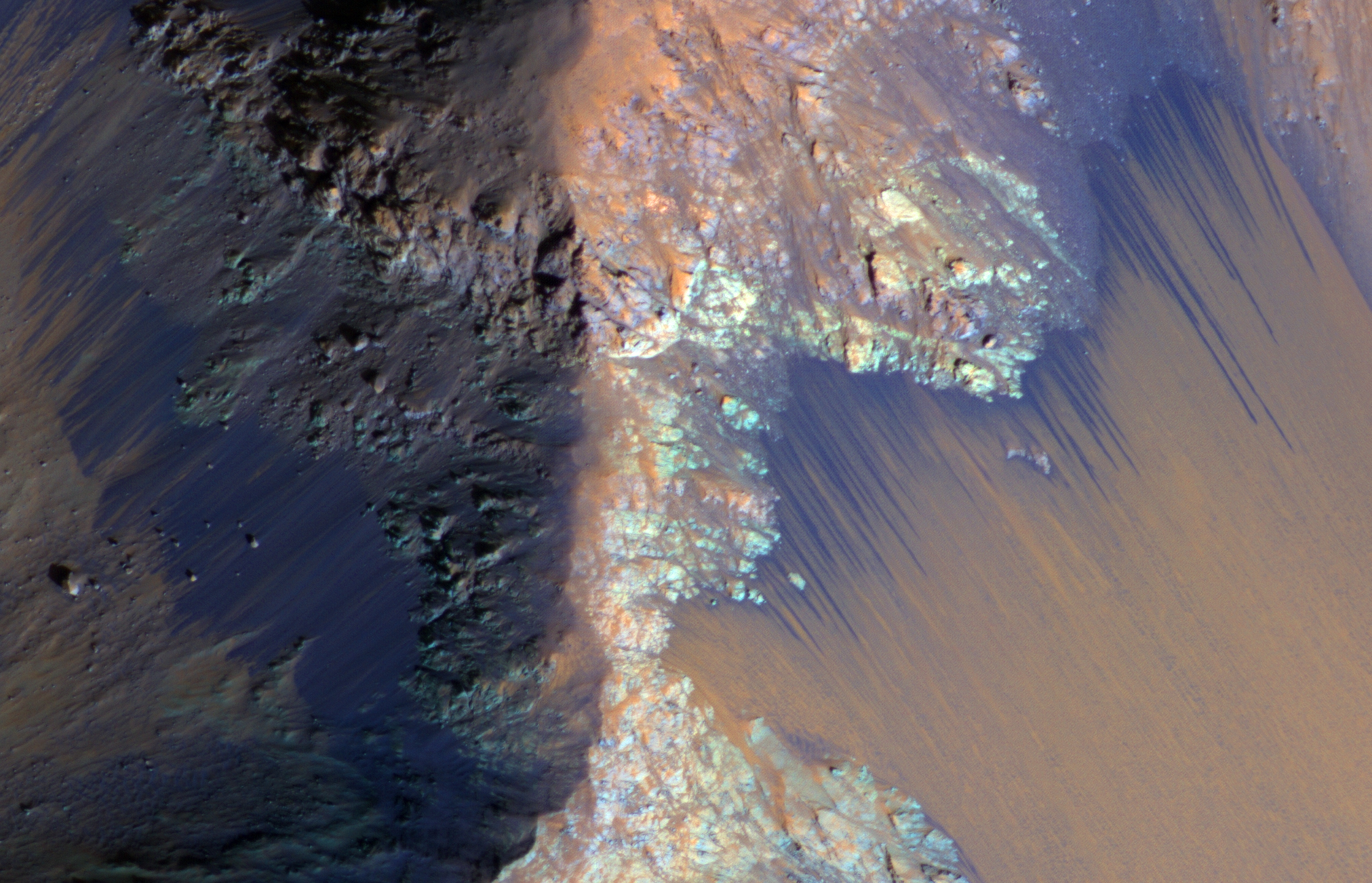
A dramatic, fresh impact crater dominates this image taken by the High Resolution Imaging Science Experiment (HiRISE) camera on NASA's Mars Reconnaissance Orbiter on November 19, 2013. Researchers used HiRISE to examine this site because the orbiter's Context Camera had revealed a change in appearance here between observations in July 2010 and May 2012, bracketing the formation of the crater between those observations.

The crater spans approximately 100 feet (30 meters) in diameter and is surrounded by a large, rayed blast zone. Because the terrain where the crater formed is dusty, the fresh crater appears blue in the enhanced color of the image, due to removal of the reddish dust in that area. Debris tossed outward during the formation of the crater is called ejecta. In examining ejecta's distribution, scientists can learn more about the impact event. The explosion that excavated this crater threw ejecta as far as 9.3 miles (15 kilometers).

The crater is at 3.7 degrees north latitude, 53.4 degrees east longitude on Mars. Before-and-after imaging that brackets appearance dates of fresh craters on Mars has indicated that impacts producing craters at least 12.8 feet (3.9 meters) in diameter occur at a rate exceeding 200 per year globally. Few of the scars are as dramatic in appearance as this one.

This image is one product from the HiRISE observation cataloged as ESP_034285_1835. Other products from the same observation are available at http://uahirise.org/ESP_034285_1835.

Image credit: NASA/JPL/University of Arizona

Note: For more information, see A Spectacular New Impact Crater and Its Ejecta and NASA Mars Orbiter Examines Dramatic New Crater. This crater is located in Syrtis Major Planum to the northwest of Schroeter Crater.

Wednesday, February 5, 2014

Olympus Mons Escarpment


This VIS image shows part of the escarpment that encircles Olympus Mons. This image is located on the southeastern flank of the volcano.

Orbit Number: 53285 Latitude: 14.2544 Longitude: 228.927 Instrument: VIS Captured: 2013-12-18 09:42

Photo credit: NASA/JPL-Caltech/Arizona State University

Tuesday, February 4, 2014

Lava Flows from Olympus Mons


The narrow lava flows in this VIS image are located on the northeastern flank of Olympus Mons.

Orbit Number: 53285 Latitude: 22.6584 Longitude: 230.131 Instrument: VIS Captured: 2013-12-18 09:39

Photo credit: NASA/JPL-Caltech/Arizona State University

Dingo Gap


This view combines several frames taken by the Mast Camera (Mastcam) on NASA's Mars rover Curiosity, looking into a valley to the west from the eastern side of a dune at the eastern end of the valley. The team operating Curiosity has chosen this valley as a likely route toward mid-term and long-term science destinations. The foreground dune, at a location called "Dingo Gap," is about 3 feet (1 meter) high in the middle and tapered at south and north ends onto low scarps on either side of the gap.

The component images were taken by Mastcam's left-eye camera during early afternoon, local solar time, of the 528th Martian day, or sol, of Curiosity's work on Mars (January 30, 2014). The center of the view is about 10 degrees south of straight west. The left edge is about 20 degrees west of straight south. The right edge is northwest. The largest of the dark rocks on the sand in the right half of the scene are about 2 feet (about 60 centimeters) across.

The image has been white-balanced to show what the rocks would look like if they were on Earth. A version with two 2-meter (79-inch) scale bars at distances of about 36 feet (11 meters) and 131 feet (40 meters) away from the rover is available as Figure 1. A version with raw color, as recorded by the camera under Martian lighting conditions, is available as Figure 2.

Image credit: NASA/JPL-Caltech/MSSS

Note: For more information, see NASA Mars Rover's Color View of Likely Route West.

Monday, February 3, 2014

Harrison Rock


This view of a Martian rock target called "Harrison" merges images from two cameras on NASA's Curiosity Mars rover to provide both color and microscopic detail. Curiosity inspected the rock's appearance and composition on the mission's 514th sol, or Martian day (January 15, 2014). The Remote Micro-Imager (RMI) of the rover's Chemistry and Camera (ChemCam) instrument obtained the detail shown in the center of this view. The right-eye, telephoto-lens camera of the rover's Mast Camera (Mastcam) instrument obtained the color information and wider context. ChemCam's laser and spectrometers provided composition information.

Harrison bears elongated, light-colored crystals in a darker matrix. Some of the crystals are about 0.4 inch (1 centimeter) in size. Figure A is a version of the image with a superimposed scale bar of 5 centimeters (about 2 inches).

Based on composition information gathered from an array of ChemCam laser shots on Harrison, the elongated crystals are likely feldspars, and the matrix is pyroxene-dominated. This mineral association is typical of basaltic igneous rocks. The texture provides compelling evidence for igneous rocks at Gale Crater, where Curiosity is on a traverse to reach the lower slopes of Mount Sharp near the center of the crater.

Photo credit: NASA/JPL-Caltech/LANL/CNES/IRAP/LPGNantes/CNRS/IAS/MSSS

Sunday, February 2, 2014

Looking Past the Dune in Dingo Gap


This mosaic of images from the Navigation Camera (Navcam) on NASA's Mars rover Curiosity shows the terrain to the west from the rover's position on the 528th Martian day, or sol, of the mission (January 30, 2014). The images were taken right after Curiosity had arrived at the eastern edge of a location called "Dingo Gap." A dune across the gap is about 3 feet (1 meter) high in the middle and tapered at south and north ends onto low scarps on either side of the gap. The rover team is evaluating possible driving routes on the other side before a decision whether the cross the gap.

The view covers a panorama from south, at the left edge, to north-northwest at the right edge. It is presented as a cylindrical projection.

Photo credit: NASA/JPL-Caltech

Note: For more information, see PIA17769: Curiosity's View Past Dune at 'Dingo Gap' (Stereo) and NASA Mars Rover's View of Possible Westward Route.

Saturday, February 1, 2014

Windstreaks Between Pavonis Mons and Noctis Fossae


The windstreaks in this VIS image are located on the lava plains between Pavonis Mons and Noctis Fossae. Streaks form on the down-wind side of positive topographic features (like hills and crater rims), indicating that the winds which created these streaks blew to the north east in this region.

Orbit Number: 53285 Latitude: -1.22511 Longitude: 255.604 Instrument: VIS Captured: 2013-12-18 07:48

Photo credit: NASA/JPL-Caltech/Arizona State University

South from Husband Hill


This section from a panorama that NASA's Mars Exploration Rover Spirit acquired in October 2005 from the top of "Husband Hill" presents the view toward the south from that summit. The entire 360-degree vista from Spirit's panoramic camera (Pancam) is available at http://photojournal.jpl.nasa.gov/catalog/pia03095.

After climbing Husband Hill, Spirit spent more than four years exploring locations within this view, including the "Comanche" outcrop and the "Home Plate" area. At Comanche, the rover found carbonate minerals, evidence of an ancient wet environment that was not acidic, and also a clue that some of the carbon dioxide in Mars' original atmosphere may have been converted to carbonates. Near Home Plate, Spirit found a deposit of nearly pure silica, evidence of an ancient environment of hot springs or steam vents.

The summit of Husband Hill is a broad plateau of rock outcrops and windblown drifts about 100 meters (300 feet) higher than the surrounding plains of Gusev Crater, where Spirit landed in January 2004.

This approximately true-color scene combines images taken through three different Pancam color filters, centered on wavelengths of 750 nanometers, 530 nanometers and 430 nanometers.

Image credit: NASA/JPL-Caltech/Cornell University