Tuesday, December 31, 2013

Crater Dunes in the Borderland Between Arabia Terra and Terra Sabaea


Dunes are found on the floor of this unnamed crater located on the margin between Arabia Terra and Terra Sabaea.

Orbit Number: 52843 Latitude: 6.34777 Longitude: 10.1768 Instrument: VIS Captured: 2013-11-12 00:49

Photo credit: NASA/JPL-Caltech/Arizona State University

Saturday, December 28, 2013

Lava Flows Near Athabasca Valles


This VIS image near Athabasca Valles shows thin plate of lava. This style of lava flow is very different from other lava flows in the nearby Elysium and Tharsis volcanic complexes.

Orbit Number: 52813 Latitude: 6.58962 Longitude: 155.034 Instrument: VIS Captured: 2013-11-09 13:03

Photo credit: NASA/JPL-Caltech/Arizona State University

Friday, December 27, 2013

Channels and Flows on the Northwestern Margin of Olympus Mons


The narrow flows and channels in this VIS image are located on the northeastern margin of Olympus Mons.

Orbit Number: 52773 Latitude: 22.0982 Longitude: 230.376 Instrument: VIS Captured: 2013-11-06 06:29

Photo credit: NASA/JPL-Caltech/Arizona State University

Thursday, December 26, 2013

Slope Streaks in Arabia Terra


Dark slope streaks mark the inner rim of this unnamed crater in Arabia Terra.

Orbit Number: 52743 Latitude: 20.8045 Longitude: 14.9941 Instrument: VIS Captured: 2013-11-03 19:15

Photo credit: NASA/JPL-Caltech/Arizona State University

Wednesday, December 25, 2013

Channels and Chaotic Terrain South of Chia Crater


This complex region of channels and chaos is located south of Chia crater and east of the much larger Maja Valles.

Orbit Number: 52733 Latitude: 0.085019 Longitude: 300.406 Instrument: VIS Captured: 2013-11-02 23:37

Photo credit: NASA/JPL-Caltech/Arizona State University

Tuesday, December 24, 2013

Olympus Mons' Shadow


The shadow in today's VIS image is being cast by the steep margin on the eastern flank of Olympus Mons.

Orbit Number: 52723 Latitude: 16.5295 Longitude: 230.997 Instrument: VIS Captured: 2013-11-02 03:46

Photo credit: NASA/JPL-Caltech/Arizona State University

Sunday, December 22, 2013

Gale Crater Panorama (December 8, 2013)


NASA's Mars rover Curiosity captured this 360-degree view using its Navigation Camera (Navcam) after a 17-foot (5.3 meter) drive on 477th Martian day, or sol, of the rover's work on Mars (December 8, 2013).

This drive brought the mission's total driving distance to 3.86 miles (4.61 kilometers). The rock-studded terrain Curiosity has traversed since October 2013 appears to have accelerated the pace of wear and tear on the rover's wheels. Future drives may be charted to cross smoother ground where available.

This seam-corrected mosaic is presented in a cylindrical projection. The center of the scene faces south. North is as both ends.

Image credit: NASA/JPL-Caltech

Note: For more information, see PIA17751: Left-Front Wheel of Curiosity Rover, Approaching Three Miles, PIA17584: Rocky Mars Ground Where Curiosity Has Been Driving (Stereo), and Curiosity Team Upgrades Software, Checks Wheel Wear.

Saturday, December 21, 2013

Tharsis Lava Flows


The lava flows in this VIS image are located of the eastern margin of the Tharsis Volcanic complex.

Orbit Number: 52709 Latitude: 3.26702 Longitude: 272.733 Instrument: VIS Captured: 2013-11-01 00:12

Photo credit: NASA/JPL-Caltech/Arizona State University

Recurring Slope Linea in Valles Marineris


These images from the High Resolution Imaging Science Experiment (HiRISE) camera on NASA's Mars Reconnaissance Orbiter show how the appearance of dark markings on Martian slope changes with the seasons. The marks, called recurrent slope linea, extend down slopes during warmer months and fade away during cooler months. This animation shows the same location at several times of year. The location is in a crater on the floor of Valles Marineris, near the Martian equator.

Photo credit: NASA/JPL-Caltech/University of Arizona

Note: For more information, see PIA17605: Long, Recurring Linear Marking on Martian Slope, PIA17606: Seasonal Changes in Dark Marks on an Equatorial Martian Slope, PIA17607: Maps of Recurrent Slope Linea Markings on Mars, and NASA Mars Spacecraft Reveals a More Dynamic Red Planet.

Friday, December 20, 2013

Havel Vallis


The channel in this VIS image is called Havel Vallis.

Orbit Number: 52683 Latitude: 0.440859 Longitude: 301.894 Instrument: VIS Captured: 2013-10-29 20:52

Photo credit: NASA/JPL-Caltech/Arizona State University

Newly Formed Impact Crater in Vastitas Borealis


This image taken on May 19, 2010, shows an impact crater that had not existed when the same location on Mars was previously observed in March 2008. The new impact excavated and scattered water ice that had been hidden beneath the surface. The location is at 63.9 degrees north latitude, 44.9 degrees east longitude. The 50-meter scale bar at lower right is about 55 yards long.

The image is an excerpt from an observation by the High Resolution Imaging Science Experiment camera (HiRISE) on NASA's Mars Reconnaissance Orbiter. Additional image products from the same observation are at http://www.uahirise.org/ESP_017868_2440. The image has been processed to allow details to be seen in both the bright ice and the darker soil.

Photo credit: NASA/JPL-Caltech/University of Arizona

Note: For more information, see PIA17608: Fresh Crater Exposing Buried Ice on Mid-Latitude Mars, PIA17609: Locations of Ice-Exposing Fresh Craters on Mars, PIA17750: Mars Orbiter Laser Altimeter, Thermal Emission Imaging System, and NASA Mars Spacecraft Reveals a More Dynamic Red Planet. The location of this impact crater is in Vastitas Borealis.

Thursday, December 19, 2013

Windstreaks in Daedalia Planum


The two dark windstreaks in this VIS image are located on the extensive lava plains of Daedalia Planum.

Orbit Number: 52674 Latitude: -14.0405 Longitude: 228.23 Instrument: VIS Captured: 2013-10-29 01:12

Photo credit: NASA/JPL-Caltech/Arizona State University

Scarp Erosion in Gale Crater


This mosaic of images from the Mast Camera (Mastcam) instrument on NASA's Curiosity Mars rover shows a series of sedimentary deposits in the Glenelg area of Gale Crater, from a perspective in Yellowknife Bay looking toward west-northwest.

Curiosity's science team has estimated that the "Cumberland" rock that the rover drilled for a sample of the Sheepbed mudstone deposit (at lower left in this scene) has been exposed at the surface for only about 80 million years. The estimate is based on amounts of certain gases that accumulate in a rock when it is close enough to the surface to be bombarded by cosmic rays. An explanation for that unexpectedly young exposure age comes from improved understanding of how the layers are eroding to expose underlying layers. The explanation proposes that the mudstone is being exposed by abrasion by windblown sand, indicated by arrows. The role for wind is strongly suggested by the undercutting of the Sheepbed layer below the Gillespie Lake sandstone.

The pattern here suggests that the Yellowknife Bay outcrop is being exposed by wind-driven scarp retreat -- the sideways erosion of a vertical face.

Mastcam took the images for this mosaic during the 188th Martian day, or sol, of Curiosity's work on Mars (February 14, 2013). The 100-centimeter scale bars are about 39 inches long. A rock ledge about 8 inches (20 centimeters) high at the bottom of the scene -- where the Gillespie Lake layer meets the Sheepbed layer -- is about 50 feet (about 15 meters) from the rover's location when the images were taken. The midfield escarpment called "Point Lake" is about 118 feet (36 meters) from the rover's location. The outcrop on the near horizon, marked with a white X, is about 43 feet (13 meters) higher in elevation than the Sheepbed-Gillespie contact and at a distance of about 780 feet (240 meters).

The image has been white-balanced to show what the rocks would look like if they were on Earth.

Image credit: NASA/JPL-Caltech/MSSS

Note: For more information, see PIA17604: Scarp Retreat Model and Exposure History of 'Yellowknife Bay'.

Wednesday, December 18, 2013

Escalante Crater Dunes


The small, dark sand dunes at the bottom of this VIS image are located on the floor of Escalante Crater.

Orbit Number: 52652 Latitude: -0.014852 Longitude: 115.525 Instrument: VIS Captured: 2013-10-27 07:39

Photo credit: NASA/JPL-Caltech/Arizona State University

Age Estimation of Mudstone in Gale Crater


A rock in the Sheepbed mudstone deposit in the Yellowknife Bay area inside Gale Crater is the first rock on Mars ever to be dated by laboratory analysis of its ingredients. The analysis using measurements of the rock's potassium and argon content by NASA's Curiosity Mars rover yielded an estimate that it is 3.86 billion to 4.56 billion years old.

The mudstone is a sedimentary rock formed by particles that had started in rocks at higher elevations -- labelled on this image as "sediment sources" -- and washed downslope before being deposited at Yellowknife Bay.

The age measured for the rock is not the depositional age of the mudstone. Researchers calculate that it is a mixture of the ages of the mineral components delivered to the mudstone via stream transport from the crater rim and the highlands beyond, as indicated by the yellow symbols. Estimates of age based on the density of impact craters on different areas of Mars put the Gale impact and surrounding highlands in the range 3.6 billion to 4.1 billion years old, a good match to the new age estimate from laboratory analysis.

An unannotated version of the underlying image is available at PIA16475. This image combines elevation data from the High Resolution Stereo Camera on the European Space Agency's Mars Express orbiter, image data from the Context Camera on NASA's Mars Reconnaissance Orbiter, and color information from Viking Orbiter imagery.

Image credit: NASA/JPL-Caltech

Tuesday, December 17, 2013

Lava Flow Toe in Daedalia Planum


This VIS image of Daedalia Planum contains a narrow lava flow and shows the end of the flow. The end of a lava flow is often called the "toe" and is formed when the eruption creating the flow slows down or stops.

Orbit Number: 52611 Latitude: -22.2339 Longitude: 243.286 Instrument: VIS Captured: 2013-10-23 20:49

Photo credit: NASA/JPL-Caltech/Arizona State University

Radiation Exposure Comparisons for a Trip to Mars


Measurements with the MSL Radiation Assessment Detector (RAD) on NASA's Curiosity Mars rover during the flight to Mars and now on the surface of Mars enable an estimate of the radiation astronauts would be exposed to on an expedition to Mars. NASA reference missions reckon with durations of 180 days for the trip to Mars, a 500-day stay on Mars, and another 180-day trip back to Earth. RAD measurements inside shielding provided by the spacecraft show that such a mission would result in a radiation exposure of about 1 sievert, with roughly equal contributions from the three stages of the expedition. A Sievert is a measurement unit of radiation exposure to biological tissue. This graphic shows the estimated amounts for humans on a Mars mission and amounts for some other activities.

Image credit: NASA/JPL-Caltech/SwRI

Note: For more information, see PIA17600: Radiation Measurements on Mars.

Monday, December 16, 2013

Possible Recent Erosion in Gale Crater


Images of locations in Gale Crater taken from orbit around Mars reveal evidence of erosion in recent geological times and development of small scarps, or vertical surfaces. These two images come from the High Resolution Imaging Science Experiment (HiRISE) camera on NASA's Mars Reconnaissance Orbiter.

The image on the left shows the Yellowknife Bay area examined by NASA's Curiosity Mars rover during the rover's first 11 months on Mars. The red arrow points to the contact between the Sheepbed and Gillespie geological members. The blue arrow points to the contact between the Gillespie Lake member and overlying Glenelg member, which also forms a small scarp. These two geological contacts form scarps due to variations in rock hardness as eroded by the wind. The effect is to generate rock exposures that are relatively youthful in a geological timescale, on the order of 70 million years.

The image on the right shows the KMS_9 area, which Curiosity may investigate on the rover's route to Mount Sharp. The purple arrow points to the contact between the lowermost striated unit and the middle bedded unit. The yellow arrow marks the contact between the middle bedded unit and the upper smooth hummocky material. It is possible that the rocks adjacent to these scarps have also been only recently exhumed and exposed due to wind erosion.

The left image is a portion of HiRISE observation ESP_028335_1755, taken on August 12, 2012. Other image products from this observation are available at http://www.uahirise.org/ESP_028335_1755. The right image was taken on August 9, 2010, and other products from the same observation are available at http://www.uahirise.org/ESP_018920_175.

Image credit: NASA/JPL-Caltech/MSSS

Sunday, December 15, 2013

Juventae Chasma Topography


Color-coded topography map of Juventae Chasma. White and red show the highest terrains, while blue and purple show the deepest.

The floor of Juventae Chasma sits some 5.8 km below the surrounding plateau. It is filled with sand in the southern part (left), which takes on a smooth appearance, in contrast to the northern (right) part of this image where many blocky rock fragments have slumped down from the chasma walls. Two large mounds of layered material sit inside Juventae Chasma and comprise minerals altered by water.

This region was imaged by the high-resolution stereo camera on ESA’s Mars Express on 4 November 2013 (orbit 12,508), with a ground resolution of 16 ms per pixel. The image center is at about 4°S / 298°E.

Image credit: ESA/DLR/FU Berlin (G. Neukum)

Note: For more information, see Juventae Chasma 3D.

Saturday, December 14, 2013

Tithonium Chasma


The steep northern wall of Tithonium Chasma crosses this VIS image. Landslide deposits from slope failure can be seen at the lower left corner of the image.

Orbit Number: 52610 Latitude: -4.11268 Longitude: 274.623 Instrument: VIS Captured: 2013-10-23 18:45

Photo credit: NASA/JPL-Caltech/Arizona State University

Juventae Chasma Perspective


The largest layered mound in Juventae Chasma is seen here in close-up perspective view. It is about 53 km long, up to 20 km wide and rises some 3.3 km above the surrounding area, comparable to a small mountain range on Earth.

Its surface is etched with grooves carved by strong prevailing winds blowing through the chasma. Layers in the mound consist of sulphate-rich materials, an indication that the rocks have been altered by water.

The mound is a relic of at least 3 billion years of martian history and its layers were most likely built up as lake deposits over time. But ice-laden dust raining out from the atmosphere – a phenomenon observed at the poles of Mars – may also have contributed to the formation of the layers.

This region was imaged by the high-resolution stereo camera on ESA’s Mars Express on 4 November 2013 (orbit 12,508), with a ground resolution of 16 m per pixel. The image center is at about 4°S / 298°E.

Image credit: ESA/DLR/FU Berlin (G. Neukum)

Friday, December 13, 2013

Channels in Elysium Planitia


The channels in this VIS image are located in Elysium Planitia and were likely created by lava flow.

Orbit Number: 52601 Latitude: 12.7686 Longitude: 147.552 Instrument: VIS Captured: 2013-10-23 02:51

Photo credit: NASA/JPL-Caltech/Arizona State University

Juventae Chasma


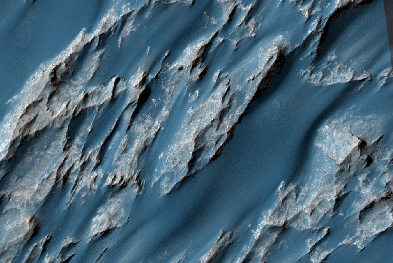
Intriguing mounds of light-toned layered deposits sit inside Juventae Chasma, surrounded by a bed of soft sand and dust.

The origin of the chasma is linked to faulting associated with volcanic activity more than 3 billion years ago, causing the chasma walls to collapse and slump inwards, as seen in the blocky terrain in the right-hand side of this image.

At the same time, fracturing and faulting allowed subsurface water to spill out and pool in the newly formed chasm. Observations by ESA’s Mars Express and NASA’s Mars Reconnaissance Orbiter show that the large mounds inside the chasma consist of sulphate-rich materials, an indication that the rocks were indeed altered by water.

The mounds contain numerous layers that were most likely built up as lake-deposits during the Chasma’s wet epoch. But ice-laden dust raining out from the atmosphere – a phenomenon observed at the poles of Mars – may also have contributed to the formation of the layers.

While the water has long gone, wind erosion prevails, etching grooves into the exposed surfaces of the mounds and whipping up the surrounding dust into ripples.

The image was taken by the high-resolution stereo camera on ESA’s Mars Express on 4 November 2013 (orbit 12 508), with a ground resolution of 16 m per pixel. The image center is at about 4°S / 298°E.

Image credit: ESA/DLR/FU Berlin (G. Neukum)

Note: For more information, see Juventae Chasma Context.

Thursday, December 12, 2013

Arcuate Fractures in Elysium Planitia


The arcuate or curved fractures in this VIS image are located on the eastern margin of Elysium Planitia.

Orbit Number: 52575 Latitude: -0.338087 Longitude: 175.334 Instrument: VIS Captured: 2013-10-20 23:34

Photo credit: NASA/JPL-Caltech/Arizona State University

Yellowknife Bay Geological Formations and Drill Sites


This mosaic of images from Curiosity's Mast Camera (Mastcam) shows geological members of the Yellowknife Bay formation, and the sites where Curiosity drilled into the lowest-lying member, called Sheepbed, at targets "John Klein" and "Cumberland." The scene has the Sheepbed mudstone in the foreground and rises up through Gillespie Lake member to the Point Lake outcrop. These rocks record superimposed ancient lake and stream deposits that offered past environmental conditions favorable for microbial life. Rocks here were exposed about 70 million years ago by removal of overlying layers due to erosion by the wind.

The 50-centimeter scale bars at different locations in the image are about 20 inches long. The lower scale bar is about 26 feet (8 meters) away from where Curiosity was positioned when the view was recorded. The upper scale bar is about 98 feet (30 meters) from the rover's location. The scene is a portion of a 111-image mosaic acquired during the 137th Martian day, or sol, of Curiosity's work on Mars (December 24, 2012). The foothills of Mount Sharp are visible in the distance, upper left, southwest of camera position.

Image credit: NASA/JPL-Caltech/MSSS

Wednesday, December 11, 2013

Candor Chasma


Shadows cast by the high walls and high hills within Candor Chasma are visible in this image. The Odyssey spacecraft and THEMIS camera are passing over the surface of Mars at a local time near 5 in the afternoon. The sun is close to the western horizon and shadows are being created by tall topographic features.

Orbit Number: 52547 Latitude: -6.7789 Longitude: 290.464 Instrument: VIS Captured: 2013-10-18 14:20

Photo credit: NASA/JPL-Caltech/Arizona State University

Possible Ancient Lake in Gale Crater


This illustration depicts a concept for the possible extent of an ancient lake inside Gale Crater. The existence of a lake there billions of years ago was confirmed from examination of mudstone in the crater's Yellowknife Bay area. For this illustration, the possible extent was estimated by mapping ancient lake and stream deposits and recognizing that water flowed from the crater rim into the basin (arrows). The water would have pooled in the linear depression created between the crater rim and Mt. Sharp. The area's history likely included the coming and going of multiple lakes of different sizes as climate conditions evolved.

The base map combines image data from the Context Camera on NASA's Mars Reconnaissance Orbiter and color information from Viking Orbiter imagery. The 25-kilometer scale bar at lower right is 15.5 miles long. North is up.

Image credit: NASA/JPL-Caltech/MSSS

Note: For more information, see PIA17594: View into 'John Klein' Drill Hole in Martian Mudstone, PIA17598: Clay Mineral Structure Similar to Clays Observed in Mudstone on Mars, PIA17599: Volatiles Released by Heating Sample Powder from Martian Rock 'Cumberland', and NASA Curiosity: First Mars Age Measurement and Human Exploration Help.

Tuesday, December 10, 2013

Dune Field in Olympia Undae


Today's VIS image shows another portion of the large dune field near the north polar cap.

Orbit Number: 52489 Latitude: 81.5273 Longitude: 162.846 Instrument: VIS Captured: 2013-10-13 21:01

Photo credit: NASA/JPL-Caltech/Arizona State University

Mars 360: The North Pole


Enjoy views of the martian north pole from all angles in this new animation from ESA’s Mars Express.

The ice cap has a diameter of about 1000 km and consists of many thin layers of ice mixed with dust that extend to a depth of around 2 km below the cap. The prominent gap in the ice cap is a 318 km-long, 2 km-deep chasm called Chasma Boreale.

The layers result from variations in the orbit and rotation of Mars that affect the amount of sunlight received at the poles, and thus the amount of melting and deposition of materials over time. Meanwhile, strong prevailing winds are thought to be responsible for shaping the spiral troughs.

The polar ice cap in this movie was constructed using data provided by the Mars Advanced Radar for Subsurface and Ionospheric Sounding instrument, MARSIS.

Low-frequency radio waves beamed towards the surface are reflected back to Mars Express from the planet’s surface and from interfaces between layers of different materials underground.

The strength and timing of the radar echoes are a gauge of the depths of different types of interfaces, such as between rock, water or ice. This information can then be translated into 3D views, as seen in this movie.

Video credit: ESA/ASI/NASA/JPL/La Sapienza University/INAF (A. Frigeri)

Saturday, December 7, 2013

Dunes in Olympia Undae


The sand dunes in this VIS image are located near the north polar cap. It is springtime and the dunes will darken with time as the winter frost sublimates in the sun.

Orbit Number: 52488 Latitude: 81.0121 Longitude: 190.215 Instrument: VIS Captured: 2013-10-13 19:18

Photo credit: NASA/JPL-Caltech/Arizona State University

Friday, December 6, 2013

Slope Streaks in Terra Sabaea


Numerous dark slope streaks are located on the inner rim of this unnamed crater in Terra Sabaea.

Orbit Number: 52480 Latitude: 0.505546 Longitude: 34.1236 Instrument: VIS Captured: 2013-10-13 03:57

Photo credit: NASA/JPL-Caltech/Arizona State University

Ithaca Rock


The rock "Ithaca" shown here, with a rougher lower texture and smoother texture on top, appears to be a piece of the local sedimentary bedrock protruding from the surrounding soil in Gale Crater. NASA's Curiosity Mars rover used its Mast Camera (Mastcam) to take this image during the 439th Martian day, or sol, of Curiosity's work on Mars (October 30, 2013). The black-outline rectangle indicates the area where the rover's Chemistry and Camera instrument (ChemCam) used its laser and remote micro-imager to inspect Ithaca. That inspection included the 100,000th laser shot fired by ChemCam on Mars. The 0.1 meter scale bar at lower left is about 4 inches.

Photo credit: NASA/JPL-Caltech/MSSS

Note: For more information, see PIA17591: Target for 100,000th Laser Shot by Curiosity on Mars, PIA17593: ChemCam Spectrum from Martian Rock Target 'Ithaca', and Laser Instrument on NASA Mars Rover Tops 100,000 Zaps.

Thursday, December 5, 2013

Slope Streaks in Terra Sabaea


Dark slope streaks mark the inner rim of this unnamed crater in Terra Sabaea.

Orbit Number: 52468 Latitude: 0.339369 Longitude: 20.0279 Instrument: VIS Captured: 2013-10-12 04:15

Photo credit: NASA/JPL-Caltech/Arizona State University

Climbing Murray Ridge


After driving uphill about 139 feet (42.5 meters) during the 3,485th Martian day, or sol, of its work on Mars (November 12, 2013), NASA's Mars Exploration Rover Opportunity captured this image with its navigation camera. The climb ascended "Murray Ridge" above "Solander Point" on the western rim of Endeavour Crater.

The view is toward the north-northeast. The distance between the two parallel tracks is about 3.3 feet (1 meter). This sol's drive brought Opportunity's cumulative driving distance to 24.01 miles (38.64 kilometers).

Photo credit: NASA/JPL-Caltech

Wednesday, December 4, 2013

Lava Channels West of Elysium Mons


The channels and linear depression in this VIS image are located on the western margin of the Elysium Volcanic complex. The channels were created by lava flow.

Orbit Number: 52464 Latitude: 29.9196 Longitude: 139.502 Instrument: VIS Captured: 2013-10-11 20:12

Photo credit: NASA/JPL-Caltech/Arizona State University

Opportunity's Traverse Map Through Sol 3486


NASA's Mars Exploration Rover Opportunity has been working on Mars since landing inside Eagle Crater on January 25, 2004 (Universal Time; evening of January 24, Pacific Standard Time). The gold line on this image shows Opportunity's route from the landing site, in upper left, to the area it is investigating on the western rim of Endeavour Crater as the date approaches for the rover's 10th anniversary on Mars, in Earth years.

The map shows Opportunity's location as of the 3,486th Martian day, or sol, of its exploration of Mars (November 13, 2013). By that sol, it had driven 24.01 miles (38.64 kilometers) and was ascending "Murray Ridge" above "Solander Point" on the rim of Endeavour Crater. The features are all within the Meridiani Planum region of equatorial Mars, which was chosen as Opportunity's landing area because of earlier detection of the mineral hematite from orbit.

The base image for the map is a mosaic of images taken by the Context Camera on NASA's Mars Reconnaissance Orbiter. The 5-kilometer scale bar is 3.1 miles long, and the diameter of Endeavour Crater is about 14 miles (22 kilometers). North is up.

Opportunity completed its three-month prime mission in April 2004 and has continued operations in bonus extended missions. It has found several types of evidence of ancient environments with abundant liquid water. The Mars Reconnaissance Orbiter reached Mars in 2006, completed its prime mission in 2010, and is also working in an extended mission.

Image credit: NASA/JPL-Caltech/MSSS/NMMNHS

Tuesday, December 3, 2013

Daedalia Planum


Today's VIS image shows a small portion of the lava flows that comprise Daedalia Planum.

Orbit Number: 52449 Latitude: -20.3058 Longitude: 233.727 Instrument: VIS Captured: 2013-10-10 12:05

Photo credit: NASA/JPL-Caltech/Arizona State University

Saturday, November 30, 2013

Lava Channel East of Olympus Mons


The channel in the bottom part of this VIS image was created by lava flow rather than water flow. This feature is located in the Tharsis plains east of Olympus Mons.

Orbit Number: 52423 Latitude: 20.9613 Longitude: 240.14 Instrument: VIS Captured: 2013-10-08 11:01

Photo credit: NASA/JPL-Caltech/Arizona State University

Friday, November 29, 2013

Rubicon Valles


Today's VIS image shows part of Rubicon Valles located on the northwestern flank of Alba Mons.

Orbit Number: 52423 Latitude: 44.6535 Longitude: 244.022 Instrument: VIS Captured: 2013-10-08 11:00

Photo credit: NASA/JPL-Caltech/Arizona State University

Thursday, November 28, 2013

Surface Textures Southeast of Aeolis Planum


The surface textures in this VIS image located southeast of Aeolis Planum likely had wind action as one of the contributing processes.

Orbit Number: 52402 Latitude: -7.56114 Longitude:150.354 Instrument: VIS Captured: 2013-10-06 15:59

Photo credit: NASA/JPL-Caltech/Arizona State University

Wednesday, November 27, 2013

Nicholson Crater


This VIS image shows part of the large deposit on the floor of Nicholson Crater.

Orbit Number: 52387 Latitude: 0.130557 Longitude: 194.999 Instrument: VIS Captured: 2013-10-05 12:18

Photo credit: NASA/JPL-Caltech/Arizona State University

Tuesday, November 26, 2013

Hydraotes Chaos


The ridges and mesas in this VIS image are part of Hydraotes Chaos.

Orbit Number: 52370 Latitude: 1.85829 Longitude: 325.257 Instrument: VIS Captured: 2013-10-04 02:43

Photo credit: NASA/JPL-Caltech/Arizona State University

Monday, November 25, 2013

Textured Mesa Southeast of Bosporus Planum


Also imaged by MRO's Context Camera, this observation shows one of two odd, rounded mesas with a knobby/pitted texture.

This mesa may be the last remnants of a formerly more extensive geologic unit. Given the particular pitted texture, this formation could be ice-rich.

High resolution images can greatly help to characterize the surface texture and allow us to compare other mid-latitude-type landforms, which may have some connection with ice and sublimation degradation processes.

Photo credit: NASA/JPL/University of Arizona

Note: These mesas are located southeast of Bosporus Planum. For more information, see PIA17703: A Textured Mesa.

Sunday, November 24, 2013

Intersection of Fractures in Echus Chasma


In this image, we see an intersection of several fractures on the floor of Echus Chasma. One "sector" appears to have been filled by a more recent viscous lava flow.

Echus Chasma is considered to be the water source region that formed Kasei Valles, a large valley that extends thousands of kilometers to the north. HiRISE may help determine the relative roles of lava and water in the region.

Photo credit: NASA/JPL/University of Arizona

Note: For more information, see PIA17704: Martian Intersection.

Saturday, November 23, 2013

Coprates Chasma


Today's VIS image shows part of Coprates Chasma.

Orbit Number: 52347 Latitude: -13.3246 Longitude: 295.016 Instrument: VIS Captured: 2013-10-02 03:24

Photo credit: NASA/JPL-Caltech/Arizona State University

Nirgal Vallis Tributaries


Nirgal Vallis is one of the largest and longest valley networks on Mars (approximately 400 kilometers in length). Oriented roughly east-west and located north of the Argyre impact basin, its western region contains numerous short, theater-headed tributaries that merge into a long, sinuous, and deeply entrenched main valley that extends eastward to Uzboi Vallis.

The area in this image (centered at -27.1730 latitude, 313.7340 longitude) is of the western most tributaries. Valley heads are steep and abrupt with blunt terminations. Although Nirgall Vallis formed long ago, likely by flowing water, abundant wind-blown sediments transformed into the dune fields that now line the valley floors. However, the distinctive valley pattern shape with steep walls and flat floors led many to propose that ground water flowed out to the surface along the valley heads and walls of the numerous tributaries. This process, known as sapping, begins with ground water flowing along subsurface fractures or permeable layers and carrying out sediments with it as it emerges at the cliff face.

Eventually, the loss of support from beneath undermines the cliff face, causing it to slump into the valley. With continued sapping, tributaries grow progressively in a headward direction. This kind of erosion is common in the Colorado Plateau of the Southwestern United States and helped form the distinctive shape of the Grand Canyon. Wrinkle ridges intersecting several tributaries may have provided additional avenues for ground water flow into the valley system.

Photo credit: NASA/JPL/University of Arizona

Note: For more information, see PIA17701: Nirgal Vallis Tributaries.

Friday, November 22, 2013

Gale Crater


This VIS image of Gale Crater shows the region of the crater that is "home" to the Curiosity Rover.

Orbit Number: 52340 Latitude: -4.58873 Longitude: 137.411 Instrument: VIS Captured: 2013-10-01 13:32

Photo credit: NASA/JPL-Caltech/Arizona State University

Hydrated Sulfate Landslides in Ophir Chasma


Giant landslides in Ophir Chasma host a variety of geologic surfaces and mineralogies. Some possess a variety of hydrated sulfate minerals that formed in the presence of partially acidic liquid water.

This image of an ancient, approximately 3 billion year-old landslide shows two distinct surface albedos, which are proportions of reflected light. These different toned surfaces also mark a transition from one sulfate mineralogy to another and variations in surface evolution.

The upper slopes to the north are light-toned due to an abundance of hydrated sulfate minerals and bright surface dust. The surfaces that make up the southern portions of the landslide are darker in tone due to the greater frequency of dark sediment that form strings of sand drifts. Additionally, the underlying units of bedrock consist of darker minerals with less hydration then those to the north, implying a change in the ancient aqueous environments that formed them.

Photo credit: NASA/JPL/University of Arizona

Note: For more information, see PIA17702: Hydrated Sulfate Landslides in Ophir Chasma.

Thursday, November 21, 2013

Iani Chaos


Several different surface textures are present on the lower elevations of Iani Chaos.

Orbit Number: 52283 Latitude: -0.827418 Longitude: 341.65 Instrument: VIS Captured: 2013-09-26 20:57

Photo credit: NASA/JPL-Caltech/Arizona State University

Murray Ridge on the Rim of Endeavour Crater


This scene shows the "Murray Ridge" portion of the western rim of Endeavour Crater on Mars. The ridge is the NASA's Mars Exploration Rover Opportunity's work area for the rover's sixth Martian winter.

The ridge rises about 130 feet (40 meters) above the surrounding plain, between "Solander Point" at the north end of the ridge and "Cape Tribulation," beyond Murray Ridge to the south. This view does not show the entire ridge. The visible ridge line is about 10 meters (33 feet) above the rover's location when the component images were taken.

The scene sweeps from east to south. The planar rocks in the foreground at the base of the hill are part of a layer of rocks laid down around the margins of the crater rim. At this location, Opportunity is sitting at the contact between the Meridiani Planum sandstone plains and the rocks of the Endeavour Crater rim. On the upper left, the view is directed about 22 kilometers (14 miles) across the center of Endeavour crater to the eastern rim.

Opportunity landed on Mars in January 2004 and has been investigating parts of Endeavour's western rim since August 2012.

The scene combines several images taken by the panoramic camera (Pancam) on NASA's Mars Exploration Rover Opportunity during the 3,446th Martian day, or sol, of the mission's work on Mars (October 3, 2013) and the following three sols. On Sol 3451 (October 8, 2013), Opportunity began climbing the ridge. The slope offers outcrops that contain clay minerals detected from orbit and also gives the rover a northward tilt that provides a solar-energy advantage during the Martian southern hemisphere's autumn and winter.

The rover team chose to call this feature Murray Ridge in tribute to Bruce Murray (1931-2013), an influential advocate for planetary exploration who was a member of the science teams for NASA's earliest missions to Mars and later served as director of NASA's Jet Propulsion Laboratory, in Pasadena.

This view is presented in approximately true color, merging exposures taken through three of the Pancam's color filters, centered on wavelengths of 753 nanometers (near-infrared), 535 nanometers (green) and 432 nanometers (violet).

Image credit: NASA/JPL-Caltech/Cornell/Arizona State University

Note: For more information, see PIA17583: 'Murray Ridge' on Rim of Endeavour Crater on Mars, False Color, PIA17585: Opportunity's View Climbing 'Murray Ridge', PIA17586: A New Perspective on Murray Ridge, PIA17588: 'Murray Ridge' in Stereo from Mars Rover Opportunity, and Mars Rover Teams Dub Sites in Memory of Bruce Murray.

Wednesday, November 20, 2013

Wind Streaks in Syrtis Major Planum


This image shows several wind streaks in Syrtis Major Planum.

Orbit Number: 52279 Latitude: 9.12948 Longitude: 69.5053 Instrument: VIS Captured: 2013-09-26 14:58

Photo credit: NASA/JPL-Caltech/Arizona State University