
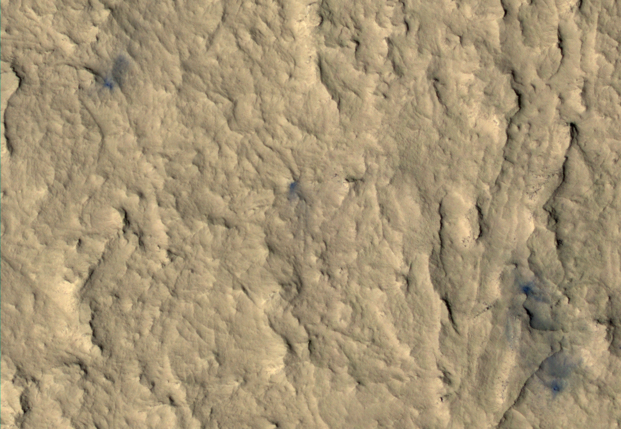
The windstreaks in this VIS image are located in Terra Sabaea.
Orbit Number: 49645 Latitude: -1.41541 Longitude: 71.1413 Instrument: VIS Captured: 2013-02-21 19:08
Photo credit: NASA/JPL-Caltech/Arizona State University
The windstreaks in this VIS image are located in Terra Sabaea.
Orbit Number: 49645 Latitude: -1.41541 Longitude: 71.1413 Instrument: VIS Captured: 2013-02-21 19:08

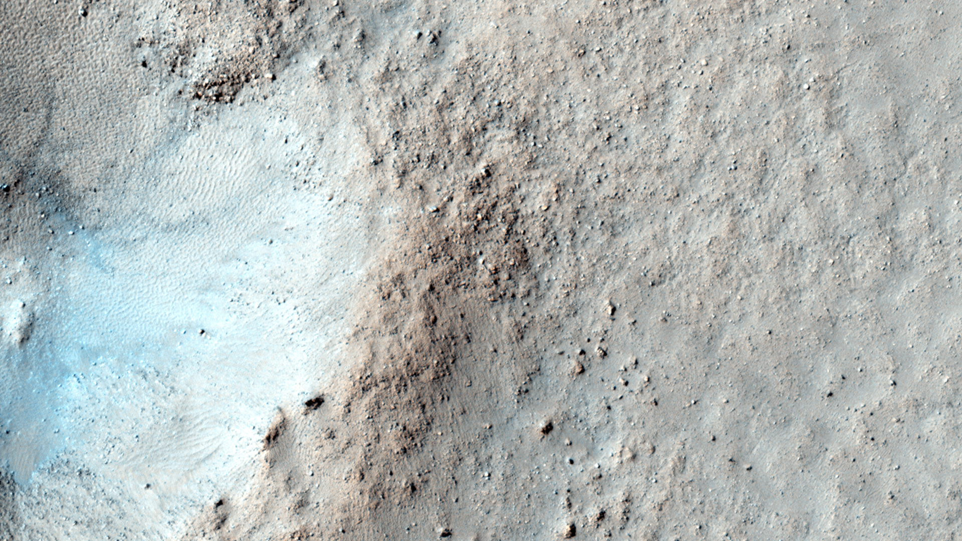
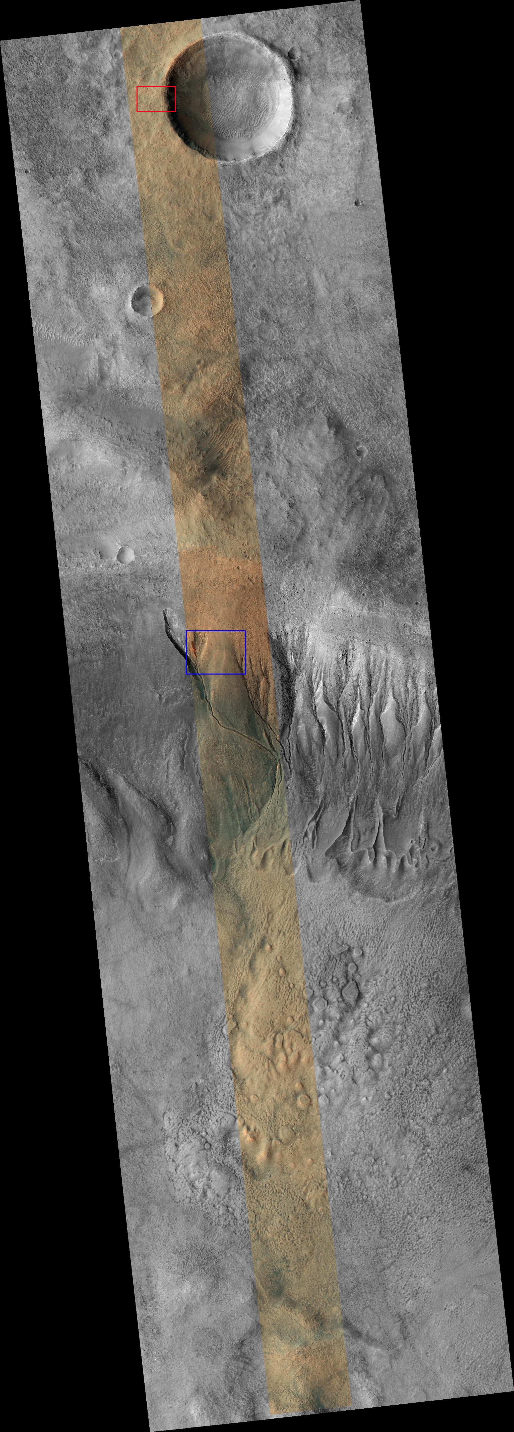
Mawrth Vallis, one of the oldest valleys on the Red Planet, was one of the final four candidate landing spots for the Mars Science Laboratory and for good reason: there are clay minerals here that most likely formed in the presence of water.
This particular image is part of a collection of observations to support assessment of potential future rover landing sites. The region is rich in aluminum- and iron-bearing clays.
This is a stereo pair with ESP_023567_2000.

The network of channels in this VIS image are part of Arda Valles.
Orbit Number: 49636 Latitude: -20.0135 Longitude: 328.071 Instrument: VIS Captured: 2013-02-21 01:27

This observation shows a crater with a surrounding bench. The crater's original rim appears to have been eroded, but mainly above a resistant layer. It's this sort of layering that gives the crater such a distinctive, "double-ring" appearance.
The image shows fine layering in both the bench and the inner crater walls. The interior of the crater--itself ringed by darker material--appears relatively featureless except for the ripples caused by wind.
This is a stereo pair with ESP_023382_1845.

The volcanic flows in today's VIS image are part of Daedalia Planum. The flows originated at Arsia Mons.
Orbit Number: 49639 Latitude: -20.7381 Longitude: 241.465 Instrument: VIS Captured: 2013-02-21 07:23

This image shows a small impact crater, about 400 meters (440 yards) wide. This crater is in the Southern mid-latitudes, at about 55 degrees south.
On Mars, fresh-looking craters are rare in the middle and high latitudes. Asteroids hit the surface there just as often as at the equator, but the craters are buried by frost and dust, or re-worked by ground ice expanding and contracting as it warms up and cools off each year.
Although this crater looks fresh, it is already showing signs that it is being filled in and eroded. Eventually, all that will be left is a shallow circular pit and perhaps a ring of boulders where the rim and ejecta used to be.

This VIS image shows a channel entering a crater in the region called Libya Montes.
Orbit Number: 49631 Latitude: 2.87567 Longitude: 86.5428 Instrument: VIS Captured: 2013-02-20 17:26

This VIS image shows a landslide deposit in Ganges Chasma.
Orbit Number: 49624 Latitude: -7.71118 Longitude: 315.758 Instrument: VIS Captured: 2013-02-20 01:41

This view of Curiosity's left-front and left-center wheels and of marks made by wheels on the ground in the "Yellowknife Bay" area comes from one of six cameras used on Mars for the first time more than six months after the rover landed. The left Navigation Camera (Navcam) linked to Curiosity's B-side computer took this image during the 223rd Martian day, or sol, of Curiosity's work on Mars (March 22, 2013). The wheels are 20 inches (50 centimeters) in diameter.
Curiosity carries a pair of main computers, redundant to each other, in order to have a backup available if one fails. Each of the computers, A-side and B-side, also has other redundant subsystems linked to just that computer. Curiosity operated on its A-side from before the August 2012 landing until February 28, when engineers commanded a switch to the B-side in response to a memory glitch on the A-side. One set of activities after switching to the B-side computer has been to check the six engineering cameras that are hard-linked to that computer. The rover's science instruments, including five science cameras, can each be operated by either the A-side or B-side computer, whichever is active. However, each of Curiosity's 12 engineering cameras is linked to just one of the computers. The engineering cameras are the Navigation Camera (Navcam), the Front Hazard-Avoidance Camera (Front Hazcam) and Rear Hazard-Avoidance Camera (Rear Hazcam). Each of those three named cameras has four cameras as part of it: two stereo pairs of cameras, with one pair linked to each computer. Only the pairs linked to the active computer can be used, and the A-side computer was active from before landing, in August, until February 28.
All six of the B-side engineering cameras have been used during March 2013 and checked out OK.

An arc of dunes covers part of the floor of this unnamed crater in Aonia Terra.
Orbit Number: 49601 Latitude: -55.8859 Longitude: 250.72 Instrument: VIS Captured: 2013-02-18 04:31

This mosaic shows part of the Noctis Labyrinthus region, the ‘Labyrinth of the Night’, on Mars. It was composed by Bill Dunford using scenes available in the Mars Express image archive, HRSCview.

This VIS image shows the complex region where Ladon Valles enters a topographic low in Margaritifer Terra.
Orbit Number: 49561 Latitude: -20.9097 Longitude: 330.385 Instrument: VIS Captured: 2013-02-14 21:19

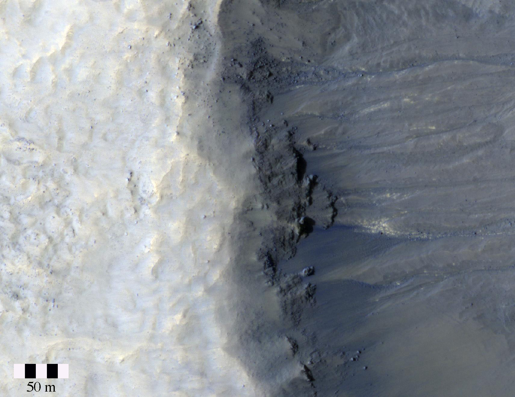
The purpose of this observation is to image dunes where substantial "gullies" formed in the previous Mars winter. These features likely formed due to carbon dioxide defrosting or the weight causing the surface to slump.
The gullies at this site are particularly large, which is intriguing, suggesting that this site be monitored to see if stages of gully formation or details of activity can be observed.

Today's VIS image shows a portion of Coprates Catena, a shallow system of connecting depressions south of Coprates Chasma.
Orbit Number: 49612 Latitude: -15.2258 Longitude: 300.704 Instrument: VIS Captured: 2013-02-19 02:01

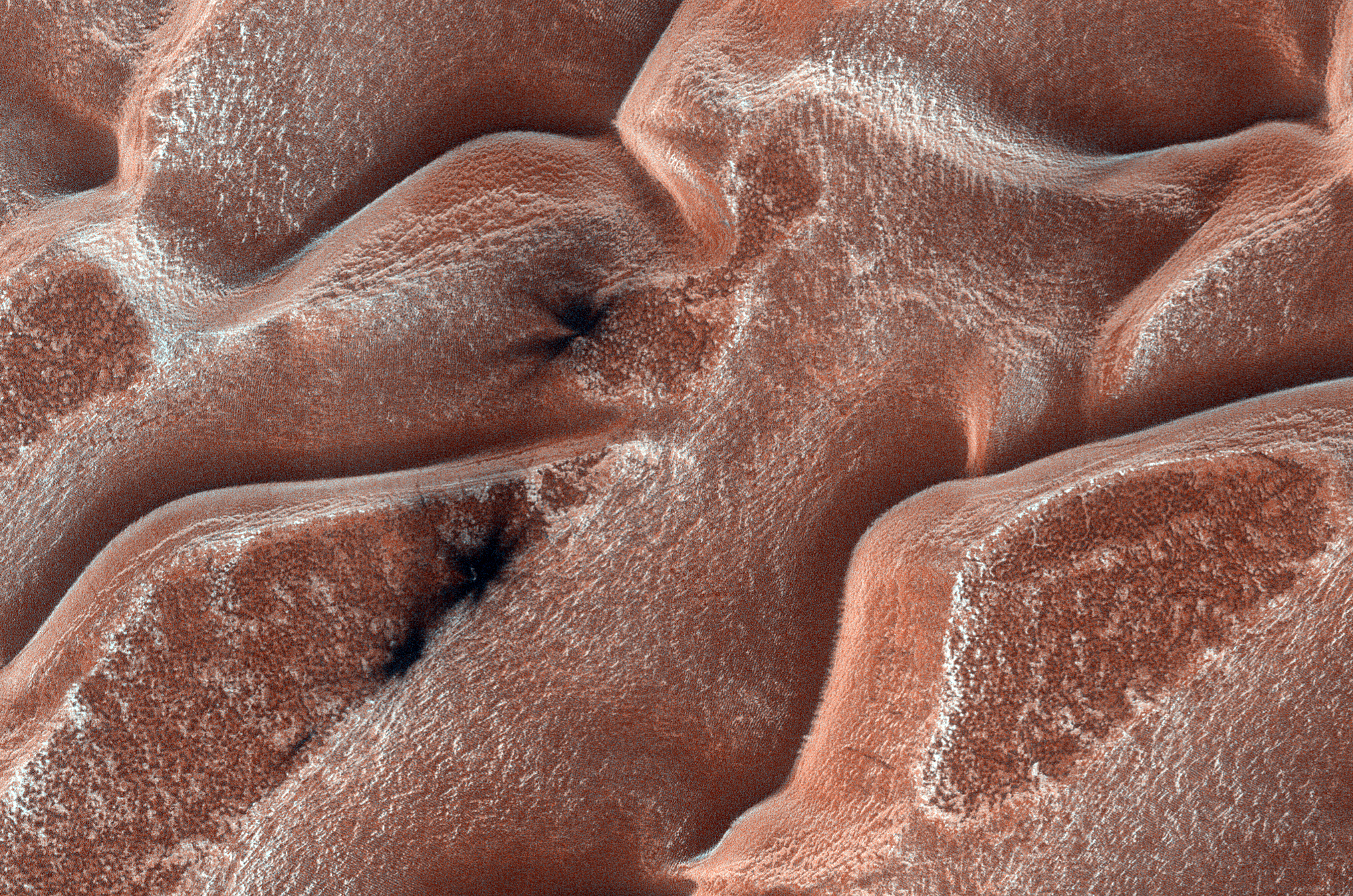
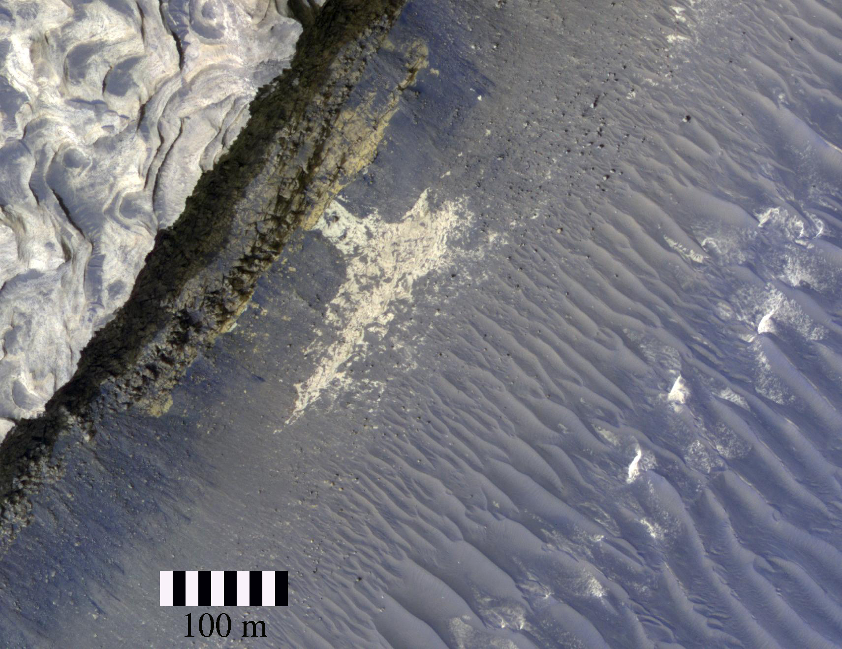
The most striking aspect of this image is the honeycomb-like pattern of the dunes.
This is a seasonal monitoring site, meaning HiRISE takes pictures across the seasons to view what changes occur and what causes them. The surface here is covered with seasonal carbon dioxide frost. In this case, we can compare locations of cracks in the frost to previous images.
In this subimage, [to be added], we see a dark spot on the slope of a dune. This is most likely caused by sublimation, where a solid passes directly into a gaseous state. The frost is translucent (some light passes through), so it sublimates at the base and pressure builds up. When the gas escapes, it can expose the dark ground or throw sand on top of the frost, producing dark spots like these.

Light-toned nodules and veins are visible in this image from NASA's Mars rover Curiosity of a patch of sedimentary rock called "Knorr." The target is in the "Yellowknife Bay" area of Gale Crater, close to where Curiosity found evidence of an ancient environment favorable for microbial life. The rover's Mast Camera (Mastcam) recorded this raw image during the 133rd Martian day, or sol, of Curiosity's work on Mars (December 20, 2012). The width of the area shown in the image is about 10 inches (25 centimeters).

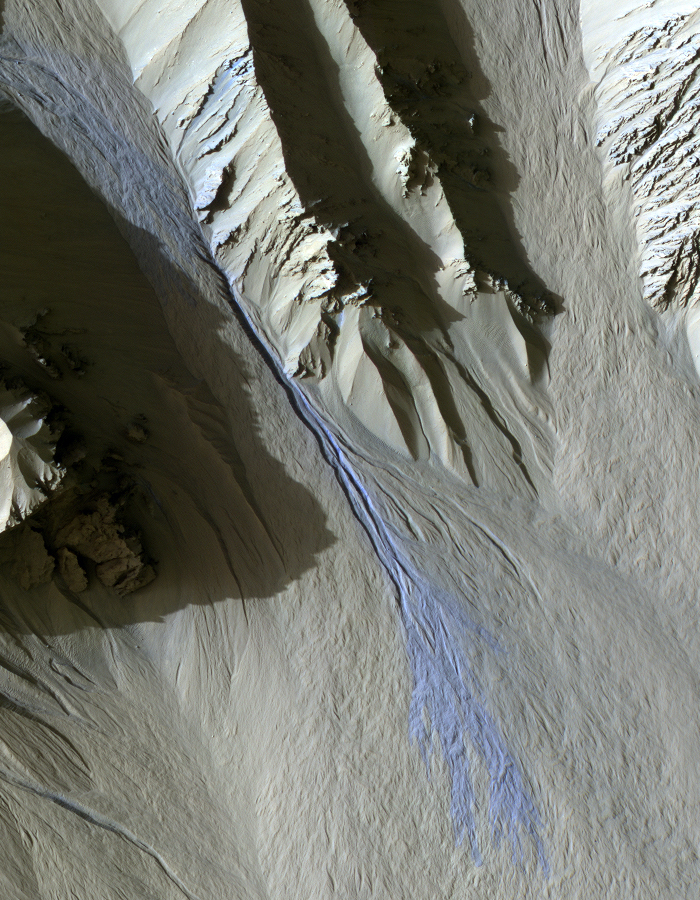
This observation shows a sinuous ridge that may be an inverted stream. Streams can be inverted (become ridges) if they are made of stronger material than their surroundings.
Another way to make high-standing channels is to have water and sediment flow through a channel in the ice at the bottom of a glacier. After the glacier is gone, the sediment can be left behind, forming a ridge called an esker.

The Mast Camera (Mastcam) on NASA's Mars rover Curiosity showed researchers interesting color and patterns in this unnamed rock imaged during the 27th Martian day, or sol, of the rover's work on Mars (September 2, 2012). The rock is about 2.4 inches (6 centimeters) across. This view is calibrated to estimated "natural" color, or approximately what the colors would look like if we were to view the scene ourselves on Mars. The rock shows a blue-black color overall, with lighter, whitish tones in patterns that may indicate the presence of distinct crystals of different material in the rock.

Although Mars has a thin atmosphere, the wind is nevertheless strong enough to move some sand dunes and ripples (collectively termed "bedforms"). Such changes have been recorded by HiRISE. Our team is continuing to monitor areas with bedforms to see if they have moved.
This image, of Aureum Chaos, is one such region. Aureum Chaos is a jumbled assemblage of large terrain blocks that were disrupted by some ancient process. The edges of the blocks commonly display layered rock strata and the lower regions between the blocks can trap sand. Both are visible here.
In a preliminary comparison with another image acquired two Mars years ago, no bedform changes are obvious, although a more thorough analysis is still needed (the best way to determine if motion has occurred is to get a topographic model of the region and then "warp" the images to fit the topography, thereby removing distortions inherent in the viewing geometry). Nevertheless, this image is rich in geologic detail. If we zoom into one region, abundant, large ripples are visible toward the lower right. On the wall at middle to upper right, two colors of rock are visible, an upper yellowish unit and a lower whitish one. These likely represent distinct rock strata that were deposited before Aureum Chaos formed.

The Mast Camera (Mastcam) on NASA's Mars rover Curiosity showed researchers interesting internal color in this rock called "Sutton Inlier," which was broken by the rover driving over it. The Mastcam took this image during the 174th Martian day, or sol, of the rover's work on Mars (January 31, 2013). The rock is about 5 inches (12 centimeters) wide at the end closest to the camera. This view is calibrated to estimated "natural" color, or approximately what the colors would look like if we were to view the scene ourselves on Mars. The inside of the rock, which is in the "Yellowknife Bay" area of Gale Crater, is much less red than typical Martian dust and rock surfaces, with a color verging on grayish to bluish.

This close-up view of "Tintina" was taken by the rover's Mars Hand Lens Imager (MAHLI) on Sol 160 (Jan. 17, 2013) and shows interesting linear textures in the bright white material on the rock. Curiosity studied Tintina with the Mast Camera (Mastcam) science filters on sols 160 and 162 (January 17 and 19, 2013). The size of the rock is roughly 1.2 inches by 1.6 inches (3 centimeters by 4 centimeters).
This raw image of "Tintina," a broken rock fragment in a rover wheel track, was taken by Curiosity's Mast Camera (Mastcam). When Curiosity drove over Tintina, the rock broke apart and exposed a fresh, bright white surface that may be the same as similarly bright material filling pale veins in the nearby bedrock of the "Yellowknife Bay" area. The Mast Camera (Mastcam) on NASA's Mars rover Curiosity took this image of Tintina during the 160th Martian day, or sol, of the rover's work on Mars (January 17, 2013). The size of the rock is roughly 1.2 inches by 1.6 inches (3 centimeters by 4 centimeters).

Gullies are found on many slopes in the middle and near-polar latitudes of Mars. Although they contain no liquid water today, whether and how much water may have been involved in their formation, and any water's origin, is a matter of considerable debate.
The gullies appear relatively young, so a current process, perhaps involving ground ice or condensed volatiles--water or carbon dioxide--may be at work. Regardless, HiRISE images provide insight on gully origins and processes.
In this image, we see gullies within two craters in Terra Sirenum. One closeup shows gully alcoves touching a crater wall. Dark sand fills the alcoves and scattered boulders are apparent. Some bright rocks on the gully walls are visible, perhaps exposed by the processes that carved the gullies.
Another closeup shows gullies that are much larger than those to the north. Intriguing yellowish colors are visible on some of the walls. Determining whether this represents chemical alteration of the walls by water, or exposed, unaltered bright rock, will require further study.

These three versions of the same image taken by the Mast Camera (Mastcam) on NASA's Mars rover Curiosity illustrate different choices that scientists can make in presenting the colors recorded by the camera. The left image is the raw, unprocessed color, as it is received directly from Mars (and as available on the MSL Raw Images Web site: http://mars.jpl.nasa.gov/msl/multimedia/raw/). The center rendering was produced after calibration of the image to show an estimate of "natural" color, or approximately what the colors would look like if we were to view the scene ourselves on Mars. The right image shows the result of then applying a processing method called white-balancing, which shows an estimate of the colors of the terrain as if illuminated under Earth-like, rather than Martian, lighting.
The image was taken by the Mastcam on Sol 19 of Curiosity's mission on Mars (August 23, 2012), using only the camera's red-green-blue Bayer filters. It looks south-southwest from the rover's landing site toward Mount Sharp.

Gully landforms like those in this image are found in many craters in the mid-latitudes of Mars. Changes in gullies were first seen in images from the Mars Orbiter Camera in 2006, and studying such activity has been a high priority for HiRISE. Many examples of new deposits in gullies are now known.
This image shows a new deposit in Gasa Crater, in the southern mid-latitudes. The deposit is distinctively blue in enhanced-color images. This image was acquired in southern spring, but the flow that formed the deposit occurred in the preceding winter.
Current gully activity appears to be concentrated in winter and early spring, and may be caused by the seasonal carbon dioxide frost that is visible in gully alcoves in the winter.

Planetary surfaces can be very complex and record many different events and modifications. Scientists try to reconstruct the history of these surfaces by looking to see how features overlap.
In this image you can see a circular impact crater about 2 kilometers (1.25 miles) across. Cutting through the crater is a trench running from the top of the image to the bottom. Geologists call these trenches "graben," which actually means trench in German. They are formed when the surface stretches apart to the left and right forming cracks. When these cracks open a block of rock can drop downwards, this block is the flat floor of the trench you see here.
In this case, the crater existed first before the graben formed. Half of the crater rim is sitting on the trench floor while the other half remains on the surrounding high ground. Despite being torn in two by the graben, both halves of the crater are in pristine condition indicating that these features are all geologically young.

This mosaic of images from the Mast Camera (Mastcam) on NASA's Mars rover Curiosity shows Mount Sharp in raw color as recorded by the camera. Raw color shows the scene's colors as they would look in a typical smart-phone camera photo, before any adjustment.
Mount Sharp, also called Aeolis Mons, is a layered mound in the center of Mars' Gale Crater, rising more than 3 miles (5 kilometers) above the crater floor, where Curiosity has been working since the rover's landing in August 2012. Lower slopes of Mount Sharp are the major destination for the mission, though the rover will first spend many more weeks around a location called "Yellowknife Bay," where it has found evidence of a past environment favorable for microbial life.
This mosaic was assembled from dozens of images from the 100-millimeter-focal-length telephoto lens camera mounted on the right side of the Mastcam instrument. The component images were taken during the 45th Martian day, or sol, of Curiosity's mission on Mars (September 20, 2012). The sky has been filled out by extrapolating color and brightness information from the portions of the sky that were captured in images of the terrain.

This mosaic of images from the Mast Camera (Mastcam) on NASA's Mars rover Curiosity shows Mount Sharp in a white-balanced color adjustment that makes the sky look overly blue but shows the terrain as if under Earth-like lighting. White-balancing helps scientists recognize rock materials based on their experience looking at rocks on Earth. The Martian sky would look more of a butterscotch color to the human eye. White balancing yields an overly blue hue in images that have very little blue information, such as Martian landscapes, because the white balancing tends to overcompensate for the low inherent blue content.

A small fan-shaped delta is located where a channel meets the floor of this unnamed crater in Terra Cimmeria.
Orbit Number: 49555 Latitude: -10.6514 Longitude: 144.802 Instrument: VIS Captured: 2013-02-14 09:02

Endeavour Crater is a large impact crater formed on Mars billions of years ago. Erosion and burial have filled in the depression and reduced the rim to a broken-up ring of hills made of rock that is older than the surrounding plains.
The Mars Exploration Rover (MER) Opportunity is currently exploring the west rim of the crater, and studying new types of rock that are very different from anything seen earlier in the mission. HiRISE images of the rest of the crater help the MER team plan their operations and understand how particular sites visited by the rover fit into the big picture.

Today's VIS image shows a small portion of the lava flows of Solis Planum.
Orbit Number: 49551 Latitude: -20.2719 Longitude: 258.768 Instrument: VIS Captured: 2013-02-14 01:34

This set of images shows the results from the rock abrasion tool from NASA's Mars Exploration Rover Opportunity (left) and the drill from NASA's Curiosity rover (right). Note how the rock grindings from Opportunity are brownish red, indicating the presence of hematite, a strongly oxidized iron-bearing mineral. Such minerals are less supportive of habitability and also may degrade organic compounds. The diameter of the abraded circle is 1.8 inches (4.5 centimeters). The image was cropped from an image http://marsrover.nasa.gov/gallery/press/opportunity/20040305a/15-jb-02-hole2-B041R1.jpg, taken on Sol 35 (the 35th Martian day of Opportunity's operations, or February 28, 2004, on Earth) by Opportunity's panoramic camera at a target called "Guadalupe" inside Eagle Crater.
On the right is the hole produced by Curiosity during the first drilling into a rock on Mars to collect a sample from inside the rock. In this case, the rock produced gray tailings -- not red -- suggesting the presence of iron that is less oxidized. One possibility is magnetite, which was determined to be present by Curiosity's Chemistry and Mineralogy instrument. Magnetite has less oxygen than hematite and would be more compatible with habitability and the preservation of organics, all other factors being equal. These other factors would include the primary concentration of organics in the sedimentary environment, in addition to later exposure of rock to surface radiation. The diameter of the hole is 0.63 inch (1.6 centimeters), which is approximately 1/3 of that on the left-hand image. The image was cropped from PIA16726. It was taken on Sol 182 (the 182d Martian day of Curiosity's operations, or February 8, 2013, on Earth) by the Mars Hand Lens Imager on Curiosity's arm after that day's drilling at a target rock called "John Klein."

A network of large and small channels dissect this highland region in Terra Cimmeria.
Orbit Number: 49492 Latitude: -34.9044 Longitude: 157.71 Instrument: VIS Captured: 2013-02-09 05:07

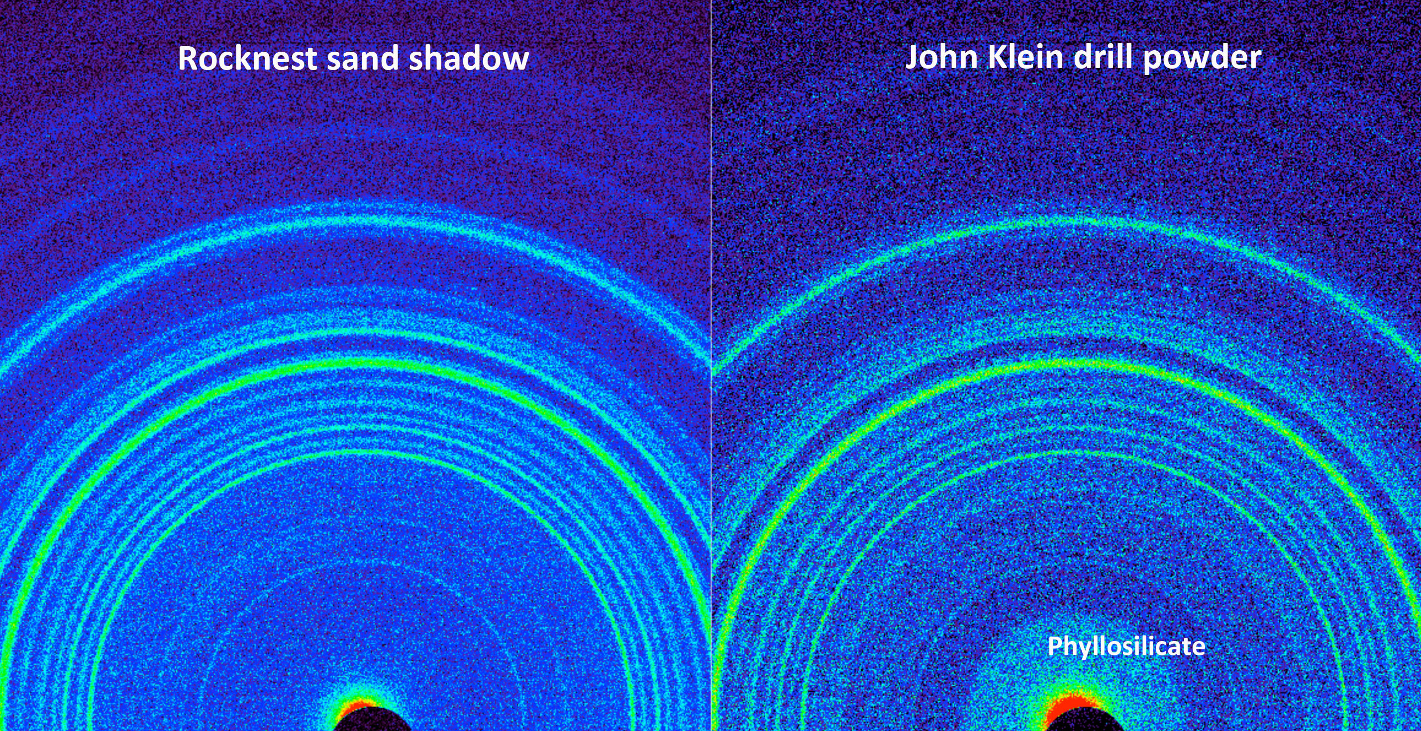
This side-by-side comparison shows the X-ray diffraction patterns of two different samples collected from the Martian surface by NASA's Curiosity rover. These images, made from data obtained by Curiosity's Chemistry and Mineralogy instrument (CheMin), show the patterns obtained from a drift of windblown dust and sand called "Rocknest" and from a powdered rock sample drilled from the "John Klein" bedrock.
The presence of abundant clay minerals in the John Klein drill powder and the lack of abundant salt suggest a fresh water environment. The presence of calcium sulfates rather than magnesium or iron sulfates (as found at Meridiani Planum by NASA's Mars Exploration Rover Opportunity) suggests a neutral to mildly alkaline pH environment. The Rocknest sand shadow mineralogy suggests a dry, aeolian (wind-shaped) environment with low water activity. The John Klein mineralogy suggests a lacustrine (lakebed) environment with high water activity.
As seen on the left, the Rocknest data reveal abundant plagioclase feldspar, pyroxene and olivine minerals. The data also indicate reveal small amounts of magnetite and anhydrite. In addition, the Rocknest sample contains 25 to 35 percent amorphous, or non-crystalline, material.
X-ray diffraction analysis of the John Klein drill powder reveals abundant phyllosilicate (a class of clay minerals called smectites that form by the action of relatively pure and neutral pH water on source minerals), plagioclase feldspar, pyroxene, magnetite and olivine. Alternatively, the clay minerals could have been transported by water from sources higher up the sediment fan to form the John Klein mineral assemblage. The region of the pattern indicating the phyllosilicates is labeled in the annotated version of this image. The data also show minor amounts of anhydrite and bassanite. The John Klein sample also contains about 20 percent amorphous material.

Many small channels dissect the rim of Martz Crater.
Orbit Number: 49480 Latitude: -34.614 Longitude: 143.722 Instrument: VIS Captured: 2013-02-08 05:24

This set of images compares rocks seen by NASA's Opportunity rover and Curiosity rover at two different parts of Mars. On the left is "Wopmay" rock, in Endurance Crater, Meridiani Planum, as studied by the Opportunity rover. On the right are the rocks of the "Sheepbed" unit in Yellowknife Bay, in Gale Crater, as seen by Curiosity.
The rock on the left is formed from sulfate-rich sandstone. Scientists think the particles were in part formed and cemented in the presence of water. They also think the concretions (spherical bumps distributed across rock face) were formed in the presence of water. The Meridiani rocks record an ancient aqueous environment that likely was not habitable due the extremely high acidity of the water, the very limited chemical gradients that would have restricted energy available, and the extreme salinity that would have impeded microbial metabolism -- if microrganisms had ever been present.
In the Sheepbed image on the right, these very fine-grained sediments represent the record of an ancient habitable environment. The Sheepbed sediments were likely deposited under water. Scientists think the water cemented the sediments, and also formed the concretions. The rock was then fractured and filled with sulfate minerals when water flowed through subsurface fracture networks (white lines running through rock). Data from several instruments on Curiosity -- the Alpha Particle X-ray Spectrometer, the Chemistry and Camera instrument, the Chemistry and Mineralogy instrument, the Mars Hand Lens Imager, the Mast Camera, and the Sample Analysis at Mars instrument -- all support these interpretations. They indicate a habitable environment characterized by neutral pH, chemical gradients that would have created energy for microbes, and a distinctly low salinity, which would have helped metabolism if microorganisms had ever been present.
Both color images have been white-€“balanced using the same technique to show roughly what they would look like if they were on Earth.
The "true color" image from Opportunity's panoramic camera (Pancam) was acquired on Sol 250 (the 250th Martian day of Opportunity's operations, which was October 6, 2004, on Earth).
The image from Sheepbed was from Curiosity's Mast Camera on Sol 192 (the 192d Martian day of Curiosity's operations, which was February 18, 2013, on Earth).

Wind has played a large role in sculpting the complex features in today's VIS image. This image is located north of Gusev Crater.
Orbit Number: 49454 Latitude: -12.3656 Longitude: 176.625 Instrument: VIS Captured: 2013-02-06 01:56
The IAU Working Group for Planetary System Nomenclature has approved new names for two features on Mars: Candor Sulci and Nia Tholus. For more information, see the IAU Gazetteer of Planetary Nomenclature.
The IAU Working Group for Planetary System Nomenclature has approved the name Farim for a crater on Mars. For more information, see the map of MC-29 in the Gazetteer of Planetary Nomenclature.

This map shows the Aram Chaos region of Mars - a crater 280 km in diameter lying almost directly on the Martian equator. In this region, the OMEGA instrument on board ESA's Mars Express found mineralogical evidence for large-scale deposits of ferric oxides (commonly known as 'rust' on Earth) and sulphates. The findings are relevant as these features are also common to other regions of Mars, widely separated from Aram Chaos, providing new hints to understand the past Martian climate.
This image is the results of the superimposition of a MOLA digital elevation model with THEMIS visible images. The inset indicates the location of Aram Chaos on a MOLA topographic map of Mars.

The finely ridged material in this VIS image are huge landslide deposits called Coprates Labes. These landslide deposits are located on the floor of Coprates Chasma.
Orbit Number: 49450 Latitude: -11.7442 Longitude: 292.003 Instrument: VIS Captured: 2013-02-05 18:02

The small channel in today's VIS image is located on the floor of Newton Crater.
Orbit Number: 49428 Latitude: -42.7553 Longitude: 201.606 Instrument: VIS Captured: 2013-02-03 22:04

This illustration schematically shows where the Shallow Radar instrument on NASA's Mars Reconnaissance Orbiter detected flood channels that had been buried by lava flows in the Elysium Planitia region of Mars.
Marte Vallis consists of multiple perched channels formed around streamlined islands. These channels feed a deeper and wider main channel.
In this illustration, the surface has been elevated, and scaled by a factor of one to 100 for clarity. The color scale represents the elevation of the buried channels relative to a Martian datum, or reference elevation. The reason the values are negative is because the elevation of the surface of Mars in this region is also a negative -- below average global elevation.

The parallel sides and low interior seen in this VIS image are faults and down-dropped material between the faults. This tectonic feature is called a graben. The graben in this image is located in Daedalia Planum.
Orbit Number: 49402 Latitude: -27.6842 Longitude: 233.651 Instrument: VIS Captured: 2013-02-01 19:18

A network of small channels is visible in today's VIS image.
Orbit Number: 49400 Latitude: -30.9108 Longitude: 290.799 Instrument: VIS Captured: 2013-02-01 15:23
The IAU Working Group for Planetary System Nomenclature has approved the name Tana Vallis for a valley on Mars. For more information, see the map of MC-11 in the Gazetteer of Planetary Nomenclature.

Comet 2013 A1 (Siding Spring) will make a very close approach to Mars in October 2014.
The latest trajectory of comet 2013 A1 (Siding Spring) generated by the Near-Earth Object Program Office at NASA's Jet Propulsion Laboratory in Pasadena, California, indicates the comet will pass within 186,000 miles (300,000 kilometers) of Mars and there is a strong possibility that it might pass much closer. The NEO Program Office's current estimate based on observations through March 1, 2013, has it passing about 31,000 miles (50,000 kilometers) from the Red Planet's surface. That distance is about two-and-a-half times that of the orbit of outermost moon, Deimos.
Scientists generated the trajectory for comet Siding Spring based on the data obtained by observations since October 2012. Further refinement to its orbit is expected as more observational data is obtained. At present, Mars lies within the range of possible paths for the comet and the possibility of an impact cannot be excluded. However, since the impact probability is currently less than one in 600, future observations are expected to provide data that will completely rule out a Mars impact.
During the close Mars approach the comet will likely achieve a total visual magnitude of zero or brighter, as seen from Mars-based assets. From Earth, the comet is not expected to reach naked eye brightness, but it may become bright enough (about magnitude 8) that it could be viewed from the southern hemisphere in mid-September 2014, using binoculars, or small telescopes.
Scientists at the Near-Earth Object Program Office estimate that comet Siding Spring has been on a more than a million-year journey, arriving from our solar system's distant Oort cloud. The comet could be complete with the volatile gases that short period comets often lack due to their frequent returns to the sun's neighborhood.
Rob McNaught discovered comet 2013 A1 Siding Spring on January 3, 2013, at Siding Spring Observatory in Australia. A study of germane archival observations has unearthed more images of the comet, extending the observation interval back to October 4, 2012.
The IAU Working Group for Planetary System Nomenclature has approved new names for two features on Mars: Aonia Mons and Aonia Tholus. For more information, see the IAU Gazetteer of Planetary Nomenclature.

Several gullies of different sizes are located on the southern rim of this unnamed crater in Terra Cimmeria. The gullies form on the north-facing rim which gets more sun related warming than the south-facing rim.
Orbit Number: 49393 Latitude: -48.25 Longitude: 129.612 Instrument: VIS Captured: 2013-02-01 01:39

This observation focuses on an unusually high density of cratered cones, imaged previously by the Mars Orbiter Camera. These cones could possibly be mud volcanos. On Earth, a large number of these formations are located in Gobustan, Azerbaijan and the Caspian Sea.
If they are mud volcanoes, what are the processes on Mars that might have created them? At HiRISE resolution, we can look for subtle flow features and compare these with other cratered cones elsewhere on Mars.
This is a stereo pair with ESP_025518_2210.

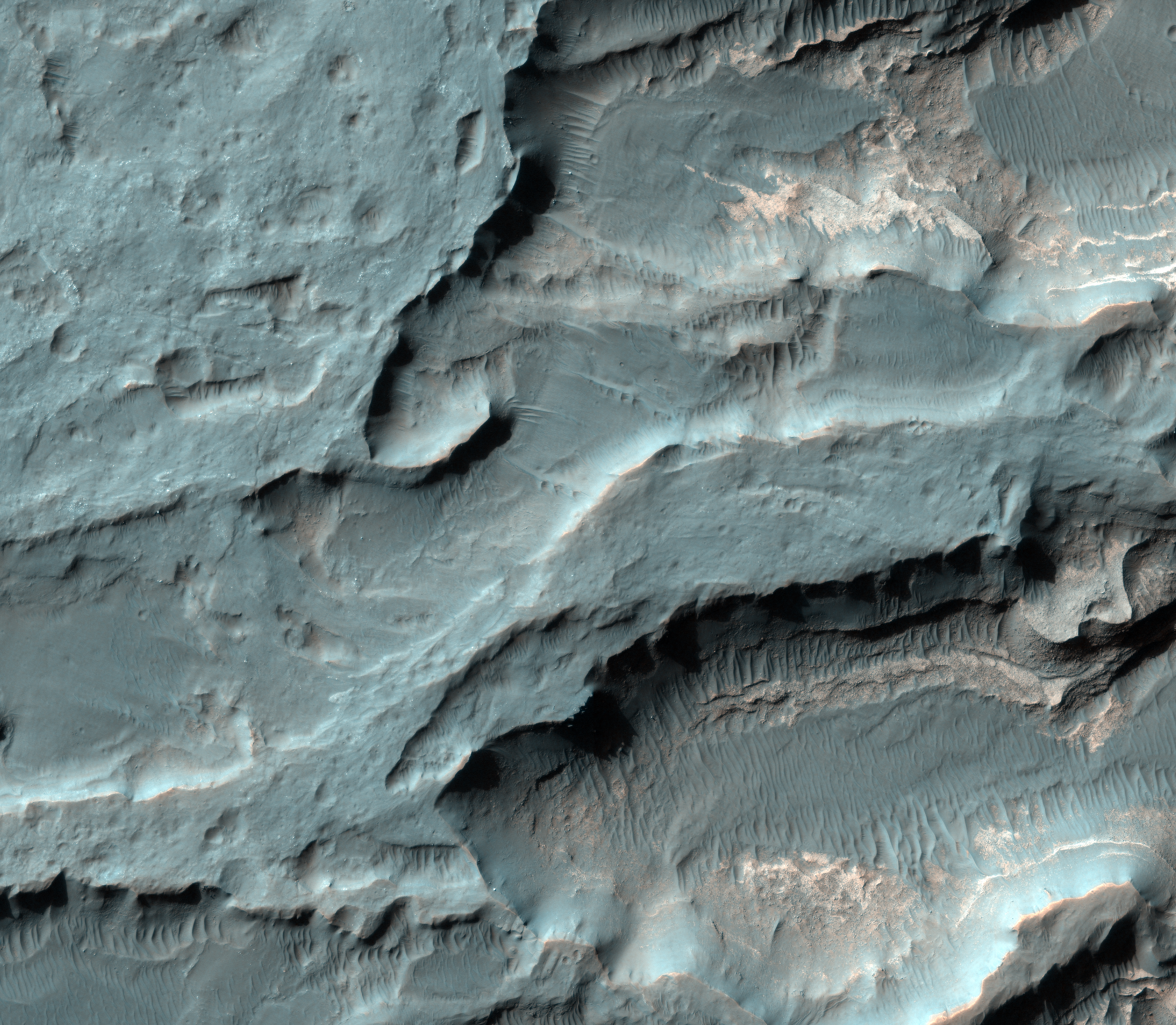
This image in Ius Chasma, a portion of the massive canyon system Vallis Marineris, draws our attention because a fault previously imaged by the Mars Orbiter Camera.
A valley cuts also cuts across the ridge. Is this the result of some tectonic process? A study in 2012 suggested that Mars possesses tectonic plates, but if so, how these processes work is still an area of study.
This is a stereo pair with ESP_017939_1720.

Several landslide deposits are visible in this VIS image of an unnamed crater in Terra Cimmeria. The bowl shaped depressions near the top of the crater rim are where the landslides started.
Orbit Number: 49355 Latitude: -36.2236 Longitude: 147.403 Instrument: VIS Captured: 2013-01-28 22:31

The Mars Science Laboratory mission released a total of 8 tungsten masses for balance purposes during entry and descent. Two 75-kilogram masses were released at the top of the atmosphere, and the resultant craters were probably imaged in ESP_029245_1755.
At a much lower altitude, six 25-kilogram masses were released shortly before deployment of the parachute in a maneuver called Straighten Up and Flight Right (SUFR), to realign the capsule center of mass with the parachute axis of symmetry. These six impact sites were first detected by CTX. This HiRISE image reveals impact craters about 2 meters wide. We captured four of these craters in enhanced color.
HiRISE has now imaged the crash sites for these 8 tungsten masses, parts of the cruise stage, the heat shield, the backshell and parachute, and the descent stage. Most of the stuff we sent to Mars crashed on the surface--everything except the Curiosity rover.

This VIS image shows windstreaks on the volcanic plains of Daedalia Planum. The "tails" indicate winds blowing from east to west (right to left on the image).
Orbit Number: 49340 Latitude: -8.97583 Longitude: 223.876 Instrument: VIS Captured: 2013-01-27 16:45

Eberswalde Crater contains layered rocks about 100-meters thick exposed in a a well-preserved delta (Malin and Edgett 2003, Moore et al. 2003).
This sedimentary deposit contains dozens of shallowly tilted, alternating bright and dark layers of varying thickness (1–10 meters). HiRISE terrain models reveal structures in these layers which are interpreted as lake-floor deposits (Lewis and Aharonson 2006, Pondrelli et al. 2008).
This delta is distinguished from other fan-shaped deposits on Mars by the presence of a preserved distributary network including lobes, inverted channels, and meander cutoffs. Another example of a fan with a distributary network can be found in Jezero Crater, which may represent a more degraded version of the same kind of system.
This is a stereo pair with PSP_001534_1560.