
The windstreaks in this VIS image are located on lava flows from Arsia Mons.
Photo credit: NASA/JPL/Arizona State University
Note: This location of this image is due west of Arsia Mons.
The windstreaks in this VIS image are located on lava flows from Arsia Mons.

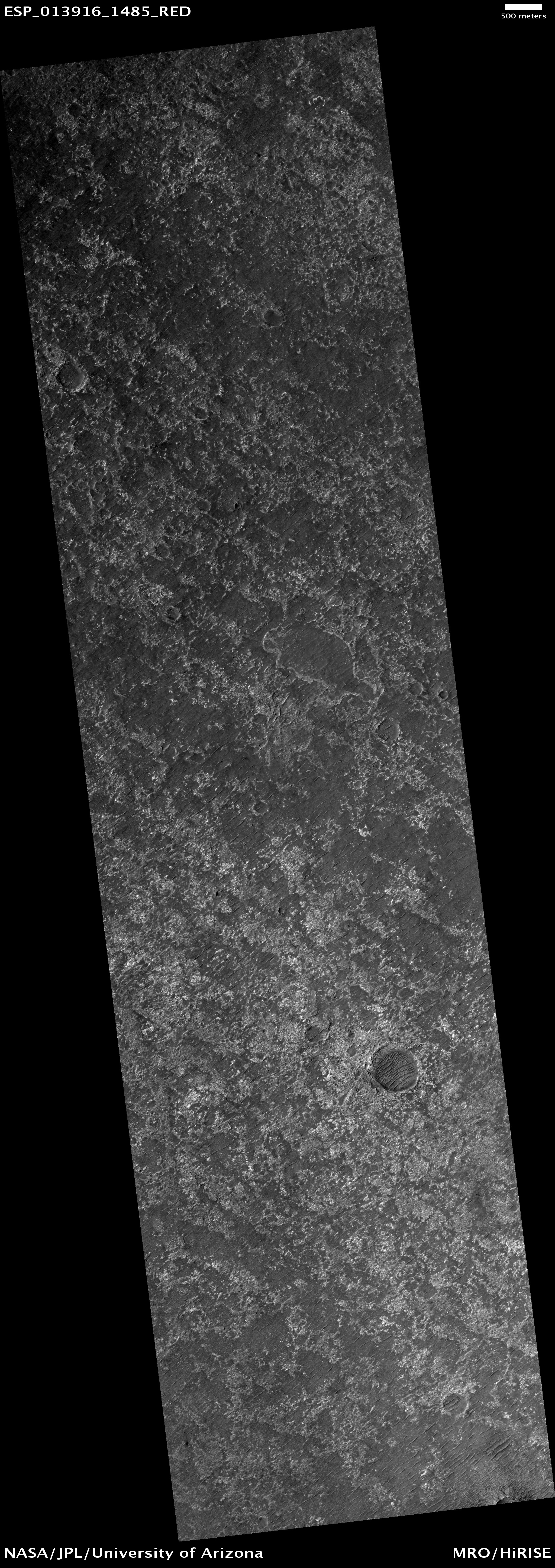
This observation shows part of an unnamed crater located in the Northern plains.
The intriguing landforms in the floor of this crater are known as "concentric crater fill." Such landforms are found at high latitudes (approximately above 30 degrees from the equator), where theoretical calculations indicate that ice may exist under the surface, mixed with rocks and soil. Examples of concentric crater fill were first observed in the 1970s, in images acquired by cameras on board the Viking orbiters.
The roughly concentric ridges and troughs in the crater's floor are believed to result from compression caused by viscous flow of a thick mixture of rocks, soils, and ice inward from the crater's walls.
Impact craters with concentric fill are usually shallower than other craters. The crater in this image is approximately 12 kilometers (7.5 miles) in diameter, and 200-400 meters (220-440 yards) deep; other Martian craters of similar diameter but without concentric fill may be as deep as 700 meters (765 yards). Unlike in "regular" craters, the slopes of the walls of craters with concentric fill tend to be convex, and the crater's rim is more rounded.
All these characteristics are consistent with deformation of an ice-rock mixture similar to what's observed in rock glaciers on Earth.

This VIS image shows dunes on the floor of an unnamed crater in Tyrrhena Terra.

Mars has a vast sea of sand dunes in the high latitude region encircling its North polar cap, known as the North polar erg. These dunes are made up of basalt and gypsum sand grains.
In some regions of the North polar erg where the sand supply is limited they take on an elongated crescent shape (see PSP_009324_2650). The icy ground that the dunes are on top of has irregular polygonal patterns. In other areas with an abundant supply of sand the dunes are continuous.
The entire North polar erg is covered in the winter with a seasonal polar cap composed of carbon dioxide (dry ice). In the springtime this seasonal polar cap evaporates. This image shows the dunes mostly still covered with dry ice, but the dark spots are places where the ice has evaporated and the dark sand of the dune is visible.

Only a portion of a large landslide deposit is shown in this VIS image. The landslide occurred on the rim of an unnamed crater southwest of Holden Crater.

The Mars Climate Sounder instrument on NASA's Mars Reconnaissance Orbiter maps the vertical distribution of temperatures, dust, water vapor and ice clouds in the Martian atmosphere as the orbiter flies a near-polar orbit.
This example of data from the instrument shows 13 orbits of nighttime temperatures at altitudes of zero to 80 kilometers (50 miles) above the surface, presented as curtains along the orbital track. Temperatures range from 120 Kelvin (minus 244 degrees Fahrenheit), coded purple, to 200 Kelvin (minus 100 degrees Fahrenheit), coded green.
The data are from March 1, 2008, which was during early spring on northern Mars. The globe of Mars depicted under the curtains is a Google Earth product using elevation data from the Mars Orbiter Laser Altimeter on NASA's Mars Global Surveyor.

Large fractures have formed 'steps' in this region of Tempe Terra.

This image displays several nice examples (see the subimage) of classical "alcove-channel-apron" gullies in a 10 kilometer (about 6 miles) diameter crater located in Mars' northern mid-latitudes.
The alcove is the cupped area near the crater rim where rock has eroded and been transported through the gully. The channel is the narrow route through which all of the alcove material is transported. That material is then deposited into the fan-shaped apron near the crater floor.
In 2006 the Mars Orbiter Camera (MOC) found evidence of new changes to the deposits in some Martian gullies. The formation mechanism for gullies on Mars is therefore an important topic of current debate: while gullies can form in the presence of water, there are also dry formation mechanisms that can produce very similar features. Scientists study gullies in part to try to help clarify the question of the history of water on Mars.

This unnamed channel is west of Flammarion Crater in Terra Sabaea.

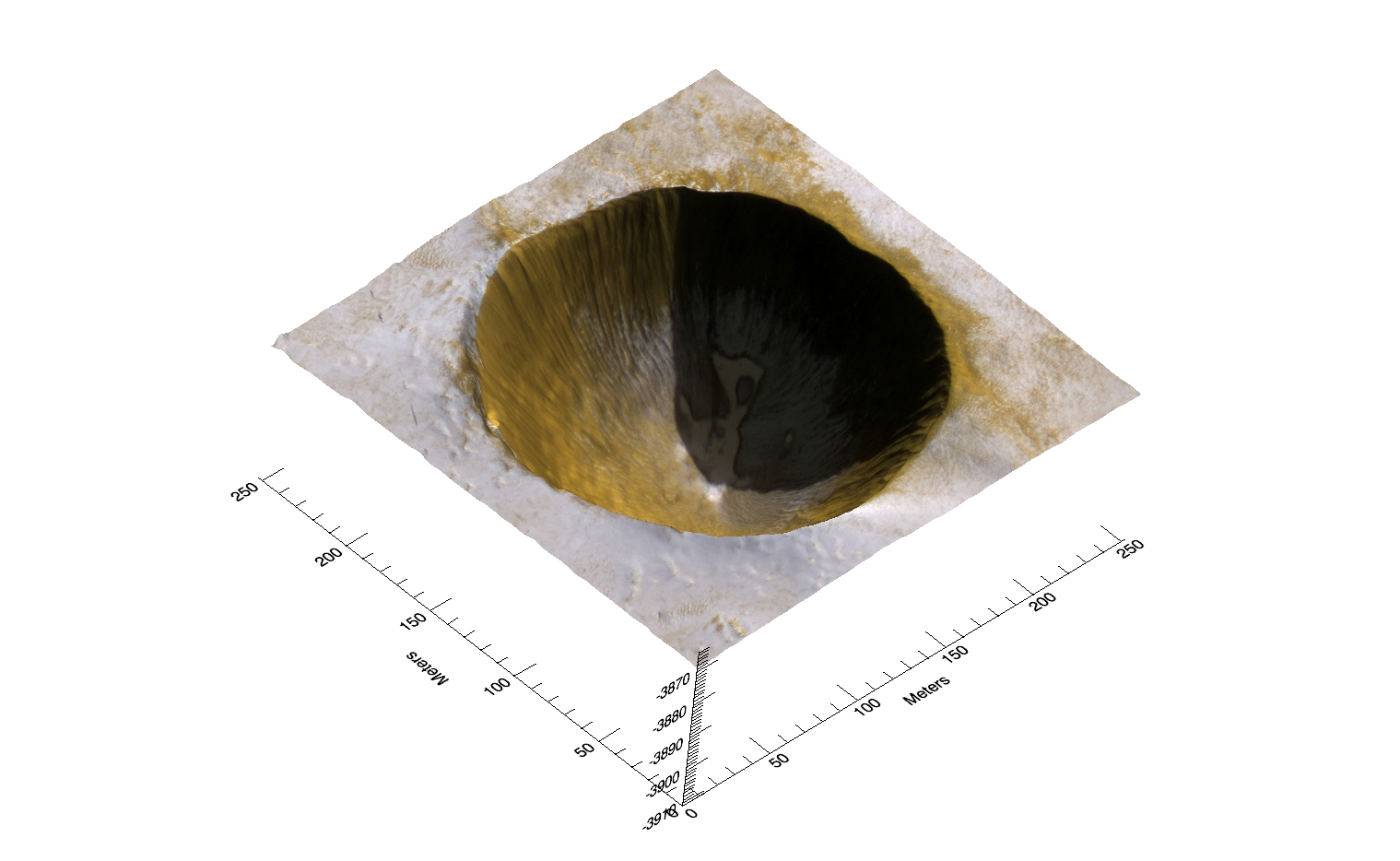
Impact craters on the North polar cap, such as the one in this digital terrain model, are rare which tells us that the landscape is being actively resurfaced. We know how often impact craters are formed and so we can deduce how fast they are being removed by looking at the size of the crater population. Craters are removed here when they fill up with fresh ice so information on how fast this ice forms can tell us about the climate of Mars both today and in the recent past.
The stereo topography allows us to calculate how much time the floor is in shadow, which determines its temperature and how fast ice accumulates there. The crater pictured here will likely last about 10,000 years before being completely filled with ice.
The perspective view shown here shows how we can combine the imagery and topography when investigating these features.

The small channels in this image of Utopia Planitia are south of Granicus Valles.

This image shows an outcrop of the south polar layered deposits (SPLD). The SPLD consist of layers of ice and admixed dust and make up the bulk of the dome-shaped Planum Australe.
Planum Australe is, in some ways, analogous to the Antarctic ice sheet. Troughs and scarps carved into Planum Australe by erosional processes have exposed SPLD layers within it. In this image, the darkest area at the bottom of the image is the bottom of the scarp. Except for the dark material at the bottom of the slope, much of the changes in brightness in this image are due to the lighting angle, the direction from which the Sun is illuminating the slope.
Much like ice cores from Greenland and Antarctica and deep sea sediment cores, the icy-dusty layers of the SPLD may have preserved a record of recent Mars climate history. Understanding that record is a complex process and involves, among many other types of analyses, examining the differences and similarities in appearance between each layer and attempting to classify layer types. This image shows nice examples of different layer textures. But what is especially interesting about this image are the faults cutting through the layers. These faults appear as diagonal lines, on either side of which, the layering is offset. Note that the faults are not clean, single lines, but appear in long groups of short lines.
What caused these faults is still under investigation, but, among other possibilities, they could be related to an earlier time when temperatures were higher and the ice was flowing at a much faster rate than it is today.

The wind-etched region in this VIS image is called Zephyria Planum.
The name Tivoli has been approved for the Martian crater located at 14.3S, 259.18W. For more information, see the database information and the map of MC-22 in the Gazetteer of Planetary Nomenclature.

HiRISE has helped the successful Mars Exploration Rovers and Phoenix Lander by giving these teams an "eye-in-the-sky" view. We are also trying to help understand why some missions were not successful.
One such mission was the Mars Polar Lander which went permanently silent after entering the Martian atmosphere in December 1999. It is speculated that the landing sequence failed when the legs were deployed and accidentally reported that the lander was on the ground. As a consequence, the parachute was cut while the lander was actually hundreds of feet in the air.
This HiRISE image is one of a sequence searching for either the parachute or the crumpled lander on the ground. However, we expect the debris from this mission to be covered with dust and ice, making it a challenge to identify them. The more eyes that search these images the better, so try your luck!
Most of the surface is covered with patches of small channels. It is thought that these have been carved by vaporized ice. On Mars, the ice goes straight to a gas (a process called "sublimation") rather than first melting. So, as the ice heats in the spring and summer, gas is generated and flows under the remaining ice. This flowing gas can move dust and slowly carve small channels.

This VIS image of the northern flank of Arsia Mons shows collapse/vent features.
The name Vaduz has been approved for the Martian crater located at 38.25N, 344.29W. For more information, see the list of Martian crater names and the map of MC-5 in the Gazetteer of Planetary Nomenclature.

UPDATED
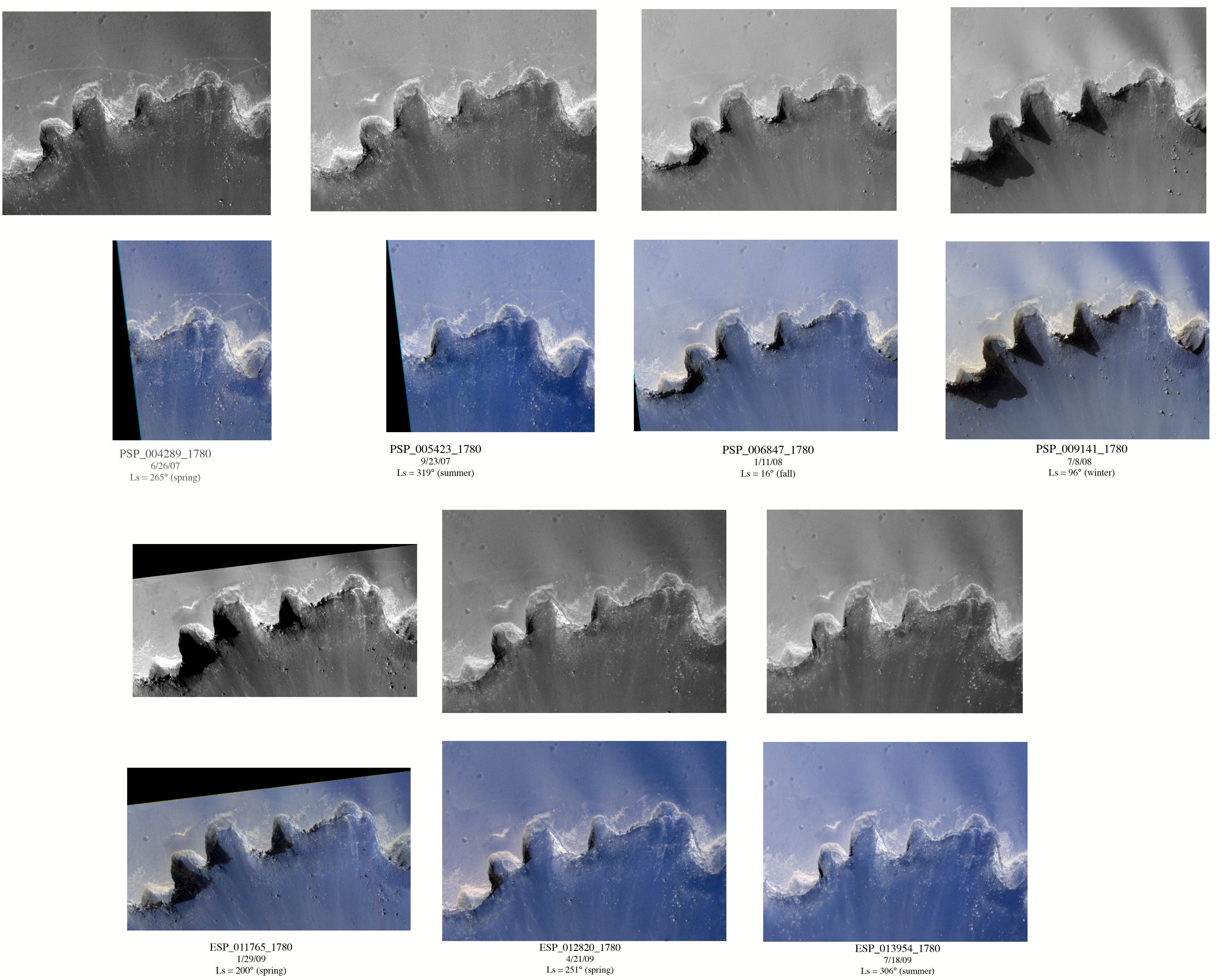
This image has an interesting perspective because of the oblique viewing geometry. In addition, the tracks of the Opportunity rover are visible just north of Victoria.
In this composite image, we show a close-up of the tracks, as well as 6 previous HiRISE views acquired since June 2007, shortly after Opportunity’s drive.
The span encompasses over a full Mars year, from southern spring to the following summer. Both the grayscale images at the top of each sequence and the color below show a progressive fading of the tracks over time. The color also shows that the tracks are initially fairly red and become bluer. This is because the weight of the rover pushed dark granules into the relatively bright, red Martian soil. Since then, dark sand has blown out of Victoria and partially covered the tracks, darkening the surface.
AN OBLIQUE VIEW OF VICTORIA CRATER
Victoria Crater was explored by Opportunity rover for more than a Mars year; HiRISE images have supported surface exploration and contributed to joint scientific studies.
HiRISE stereo data were used to measure slopes and help select safe paths for the intrepid rover. The most interesting exposures of geologic strata are in the steep walls of the crater, difficult to image from the overhead perspective of orbiting spacecraft like MRO. However, MRO can point to the sides, and did so in this case to get a better view of layers in the west-facing and sunlit slopes of the crater.
Especially prominent is a bright band near the top of the crater wall, interpreted by some MER scientists as having formed by diagenesis (chemical and physical changes in sediments after deposition). This bright band separates the bedrock from the impact ejecta deposits of Victoria Crater.
The subimage image has been rotated so that we are looking east, with MRO pointed 22 degrees east of straight down, so it is comparable to a view from an airplane window. Colors have been enhanced to show subtle differences.

This VIS image shows part of the floor of Arkhangelsky Crater. Small individual dunes are found in this region of the crater floor.

Throughout this entire image in Aonia Terra, it is possible to make out regular polygonally shaped patterns. Here on Earth, wherever ice-rich permafrost occurs (soil which stays frozen throughout the year), the ground may crack and form similar patterns to those we see on Mars.
Despite remaining below freezing, changes in seasons and ground temperature cause significant thermal-contraction stress, enough so that the terrain fractures into a honeycomb network of subsurface cracks.
Criss-crossed dark paths wind throughout this region. Dust devils, turbulent whirlwinds fueled by rising ground-warmed atmosphere, track across the surface, stripping the ground of bright surface dust as they go. Comparable to miniature tornadoes, they efficiently transport surface materials on Mars. Left in their passing is the darker coarse-grained soil underneath.
In this image, the Sun is low on the horizon; the shadows make it easier to see the scattered rocks and boulders. Sometimes, these boulders occur in rings, the remnants of an ancient impact whose crater has since eroded to a flat surface. The boulders are left behind, illustrating where the form of the crater once stood.

Dark slope streaks are found throughout Lycus Sulci.

This dune field in Aonia Terra shows sand dunes with a variety of morphologies.
These complex shapes often indicate that the dominating winds change direction, either over time or from one location to the next. Many of the dune fields in this region of Mars are banked up against topographic obstacles such as crater rims. The location of the dunes within impact craters gives an indication of the average regional winds, while details such as slip-face orientations and superposed ripples are controlled by the present day local winds.
The outlying dunes in this image appear as simple arc-shaped barchans formed by southerly winds. As the dunes migrated northwards, they encountered other dunes crowded against a confining scarp. Many of the barchans climbed up onto the upwind (stoss) slope of the next row of dunes. This migration is shown by the avalanches that have occurred on the downwind (slip) face of the dunes. The collision of the dunes altered the morphology of the barchans to star-shaped dunes with multiple arms that took on a linear appearance as the horns were modified.
There is also the presence of faint dark tracks from dust devils picking up a very thin veneer of dust on the dunes. The faintness of the tracks could be an indication that the dunes have actively saltating sand grains that clean much of the settled dust from the dunes.

Tempe Terra is criss-crossed with numerous fracture systems. This VIS image shows a region where the fractures are intersecting.

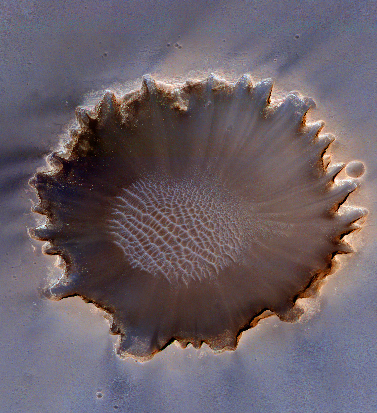
This image of Mars' south polar area shows an amazing series of elliptical rings. Could these have been made by a Zamboni on Mars driving around and around on the ice? No, of course not! But the answer in some ways more fun.
The ice caps on Mars are surrounded by a thick stack of layered deposits. HiRISE and other instruments have shown that these layers are composed of dusty ice. Imagine this stack of layers as a cake with alternating layers. Now someone comes and takes a big scoop out of the middle of the cake! While our first reaction might be to get mad at them for ruining the cake, take a moment to think what the pattern would look like: it would have rings going round and round the hole. This is what we are seeing in this image of Mars.
Some erosional process has scooped a big hole into the layered deposits. So, no Zamboni, but we do have giant scoops digging into layer-cakes of ice!

As northern summer approaches on Mars, dunes near the pole defrost and become darker appearing in VIS images.

This “etch-a-sketch” appearance indicates the presence of dust devil activity in the Thyles Rupes region of Mars.
The dark streaks are a result of a surface-atmosphere interaction that creates thermally-driven vortices. These Martian vortices are giant dust devils that “vacuum” the bright surface dust revealing the darker subsurface rock.
This image was taken in the late southern summer and shows that the dust devil direction of movement changes with the winds as the season progresses from spring to fall. Dust devils are sensitive to changes in low-speed ambient winds and will follow the dominant daytime wind direction.
The direction of the vortex is visible by the scallop pattern that is left behind as a dust devil will erase the front part of the circular track as it follows the wind.

The tectonic fractures in this VIS image are part of Aram Chaos.

A subimage of this observation shows a dust devil in action.
The swirling vortex of dust is visible near the center of the image. The shadow cast by this column of dust can be seen in the upper-left while the dark track left by the passage of the dust devil is evident in the lower-right.
Dust devils on Mars form the same way that they do on Earth. The ground heats up during the daytime, warming the air immediately above the surface. This hot layer of air rises and the cooler air above falls, creating vertical convection cells. A horizontal gust of wind will cause the convection cells to rotate, resulting in a dust devil.
As the dust devil moves across the surface of Mars, it can pick up and disturb loose dust leaving behind a darker track.

This wind eroded crater is located between Eumenides and Gordii Dorsa. The ejecta of the crater is more resistant to the wind than the surrounding materials.

This dune field is on the floor of a small crater in Noachis Terra located in the southern hemisphere of Mars.
The slip faces of the dunes have multiple directions, indicating that there were several wind directions and changes in wind strength when the dunes formed. The dominant dune type are transverse dunes (oriented perpendicular to the prevailing wind direction), with modified barchans (crescent-shaped dunes) in the northern region of the field and incipient linear dunes in the southern region.
The bright material scattered throughout the dune troughs, as well as at the bottom of the image, are outcrops of underlying bedrock.
The bottom of the image clearly displays a mass of dark dust devil tracks. Dust devils are wind funnels that suck up dust as they travel over the surface exposing the dark sandy substrate.

The dunes in this VIS image are near the north polar cap.

This observation shows a lava plain near the Martian equator. The lava is superposed by a small, fresh crater that is itself surrounded by boulders that were ejected from the surface when the impact occurred.
There are dunes on the crater floor, indicating that the crater has been present long enough for wind to blown fine material into the crater and form the material into dunes.

This VIS image of Coprates Chasma shows several landslide deposits.

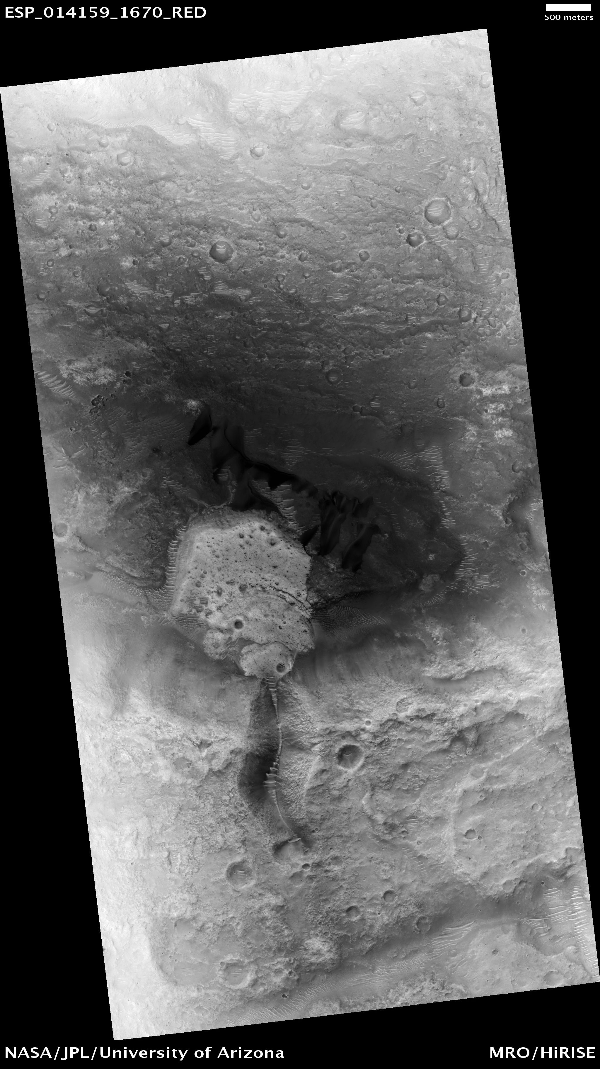
This HiRISE image shows a close-up view of the terrain northeast of Zilair Crater.
In lower-resolution images, from the Context Camera (also on board the Mars Reconnaissance Orbiter), this area looks quite rough. The reasons for this rough texture are difficult to determine; however, clues from the surrounding area help solve this mystery. Many large impact craters surround this image, but there are no volcanoes nearby making it unlikely that the rough surface is from fresh, blocky lava flows.
The high-resolution image shown here reveals a few fresh, irregularly-shaped craters on top of this rough terrain. An irregular crater, approximately 600 meters (2,000 feet) in diameter, is visible just right of center, about a third of the way up from the bottom of the image. Its shape suggests that it formed from a body that impacted the surface at a relatively low angle and slow speed. This makes it likely that it is a secondary crater (a crater that forms from debris blasted out of a nearby crater).
The rough terrain here is therefore likely to be a mix of impact material and secondary craters from nearby impacts, such as the one that formed the nearby large crater Zilair.

The interconnected collapse pits at the top of this VIS image are part of Coprates Catena. Notice the dunes in the bottom of each pit.

Several years ago gullies carved into hill-slopes and the walls of impact craters like the ones pictured here were discovered. Scientists are excited to study these features because, on Earth, they usually form through the action of liquid water - long thought to be absent on the Martian surface. Whether gullies form under today's cold dry conditions is a major question that planetary scientists are trying to answer.
The gullies pictured here are great examples of what a typical Martian gully looks like. You can see wide V-shaped channels running downhill (from top to bottom) where the material that carved the gully flowed. At the bottom of the channel this material empties out onto a fan-shaped mound. Several gullies are visible here and the fans from each gully overlap one other in complicated ways.
At the tops of the channels, large amphitheater-shaped alcoves are carved in the rock. The material removed from these alcoves likely flowed downhill to the aprons through the gullies.
Gullies at this site are especially interesting because scientists recently discovered examples at similar locations to be still active. Images separated by several years showed changes in the appearance of some of these gullies. Today, planetary scientists are using the HiRISE camera to examine gullies for ongoing change and investigate what that might mean for the occurrence of liquid water on the surface of Mars.

This VIS image of part of Meridiani Planum contains windstreaks that formed in several directions around a single crater. This indicates that wind directions changed, forming new tails for each prevailing wind direction.

Many channels formed by water (when the climate of Mars was very different to that of today) cut the ancient highlands of Mars. Water running through these channels picks up rocky debris and carries it or rolls it along the channel bed. Occasionally these channels will empty into a crater or other low point in the terrain and the water will drop the material it is transporting. This material can build up in large fan-shaped mounds at the end of the channel.
In this observation, this is likely what has happened. The fan-shaped mound (which appears bluish in this false-color image) sits at the end of a short channel. Analysis of spectroscopic data shows that the composition of this material indicates a history of interaction with liquid water. The full resolution version of this HiRISE image shows layering that indicates this material was dumped here in at least three separate episodes.
Although they may once have been common, features like this are now rare. Scientists study them to try and understand how much liquid water affected the composition and appearance of Mars in its early history.

These dark dunes are located on the floor of Danielson Crater in Meridiani Planum.
The name Milna has been approved for the Martian crater located at 23.46S, 12.31W. For more information, see the list of Martian crater names and the map of MC-19 in the Gazetteer of Planetary Nomenclature.

The south polar layered deposits are a stack of ice and dust about 3 kilometers (2 miles) thick. The many layers that make up this feature are of great interest to planetary scientists because, just as with ice sheets on Earth, they are thought to contain a record of the planet’s climate in previous times.
As with the rest of Mars, impact craters form continuously on these polar deposits. Rarely, a very large impact will occur and the crater will excavate all the way through this ice sheet to the rocky terrain underneath. This is what happened in the case of McMurdo, a crater roughly 20 kilometers (12.5 miles) across which punched through the ice-sheet in the past.
This HiRISE image shows the wall of this crater, only half of which has been preserved until current times. You can see the many layers that comprise the south polar layered deposits exposed here. Scientists study exposures like this to try to understand the length of the climatic record that is recorded in the icy material at the poles of Mars.

This streamlined island is located within Maja Valles.

This image views the ground a little over 500 kilometers (300 miles) from Hale Crater, a 125 x 150 kilometer (78 x 93 mile) impact crater located on the northern rim of the Argyre Basin.
The ground appears to have a linear pattern (somewhat easier to see viewing the entire image at once) extending from the bottom right to the top left of the image. The linear pattern of the light bedrock is especially evident in nighttime infrared images, where it appears as a series of bright streaks. The pattern points directly back to Hale Crater. It is most prominent near the crater, outside of the Argyre Basin, but a hint of it extends almost to Valles Marineris, over 1,000 kilometers (600 miles) away.
This image shows areas of bedrock (light areas) that appear to have been grooved or scoured in a uniform direction. Superimposed on this in the low-lying areas are dark areas that consist of small ridges trending in the opposite direction to the scoured bedrock. The dark areas are sand and dust, and the small ridges are aeolian bedforms (that look like linear sand dunes, averaging approximately 100-300 meters, or 300-1,000 feet) that cross the image.
The suggestion that the pattern arises from bedrock that has been scoured along a linear trend away from Hale Crater is interesting because an outward-expanding blast of pulverized debris–known as a base surge–is thought to be one of the features associated with the formation of impact craters. Images such as this may be evidence that base surges are an important part of the impact process.

This VIS image shows multiple landslide deposits within Ganges Chasma.
