Saturday, August 31, 2013

Mangala Valles


Today's VIS image was collected at the same time as yesterday's IR image. Streamlined islands are located in the channel of Mangala Valles, a portion of which is shown in the image.

Orbit Number: 51226 Latitude: -14.5365 Longitude: 209.862 Instrument: VIS Captured: 2013-07-01 21:39

Photo credit: NASA/JPL-Caltech/Arizona State University

Hadriacus Mons and Dao Vallis


This daytime IR image shows part of the patera (summit depression) and eroded flank of Hadriacus Mons at the top of the image and a section of Dao Vallis at the bottom of the image.

Orbit Number: 51230 Latitude: -33.0654 Longitude: 91.7634 Instrument: IR Captured: 2013-07-02 05:38

Image credit: NASA/JPL-Caltech/Arizona State University

Artik Crater

From the USGS Astrogeology Science Center:

The IAU Working Group for Planetary System Nomenclature has approved the name Artik for a crater on Mars. For more information, see the map of MC-29 in the Gazetteer of Planetary Nomenclature.

Lava Flow in an Impact Crater in Tartarus Montes


In this image, we can see a small notch in a crater rim with a well-formed channel. Lava appears to have flowed through this notch and filled in this approximately 10-kilometer (6-mile) diameter crater.

Obtaining another image of the same area at a different angle (what we then call a "stereo pair") can help us see this terrain in three dimensions and answer some questions about what happened here, e.g., is the high-lava mark consistent with the lava overtopping the exterior? Did the crater fill to the level of the lava outside?

This is a stereo pair with ESP_028637_2040.

Photo credit: NASA/JPL/University of Arizona

Friday, August 30, 2013

Curiosity's Route Map from Landing to Mount Sharp


NASA's Mars rover Curiosity left the "Glenelg" area on July 4, 2013, on a "rapid transit route" to the entry point for the mission's next major destination, the lower layers of Mount Sharp. As of Aug. 27, 2013, NASA's Mars rover Curiosity has driven about 0.86 mile (1.39 kilometers) since leaving Glenelg, with about 4.46 miles (7.18 kilometers) remaining to get to the entry point. The rover's drive on August 27, the 376th sol (Martian day) of the mission, was the first Curiosity drive using the rover's autonomous navigation capability to safely drive beyond the area that rover drivers on Earth could evaluate from images before the drive. The rover can analyze stereo images that it takes during the drive and choose the best path to continue driving.

The rapid transit route was plotted on the basis of images from the High Resolution Imaging Science Experiment (HiRISE) camera on NASA's Mars Reconnaissance Orbiter. Actual drives are based on images from Curiosity's own cameras, and the total driving distance to the entry point could differ from the length of the rapid transit route.

Curiosity's science team has identified some geological waypoints along the rapid transit route where driving may be suspended for a few sols to allow time for studying local features. The rover has about 0.31 mile (500 meters) left to go before reaching the first of these waypoints. For a broader-context image of the area, see http://photojournal.jpl.nasa.gov/catalog/PIA16058.

This map shows Curiosity's location at the end of the Sol 376 drive, in the context of the mission's initial drive from the landing site at Bradbury Landing to Glenelg and the route of the current drive from Glenelg to the Mount Sharp entry point. Geological waypoints along the route are also indicated. The base map is from the orbiting HiRISE camera. North is toward the top. The dark ground south of the rapid transit route has dunes of dark, wind-blown material. The 4-kilometer scale bar on the map is about 2.5 miles long.

Image credit: NASA/JPL-Caltech

Oxbows and Cutoffs in Idaeus Fossae


As rivers age they can meander and occasionally these meanders get so pronounced that the river cuts off these curving loops at their narrow end leaving them as isolated as oxbow lakes.

The objective of this observation is to check for the presence of these features. At HiRISE resolution, we should be able to test for traces of former meandering river channels in what looks like an oxbow feature in images from lower-resolution cameras.

Photo credit: NASA/JPL/University of Arizona

Thursday, August 29, 2013

Mangala Valles


This IR image shows streamlined islands in the channel of Mangala Valles.

Orbit Number: 51226 Latitude: -15.5089 Longitude: 209.731 Instrument: VIS Captured: 2013-07-01 21:39

Image credit: NASA/JPL-Caltech/Arizona State University

Annular Eclipse of the Sun by Phobos


This set of three images shows views three seconds apart as the larger of Mars' two moons, Phobos, passed directly in front of the sun as seen by NASA's Mars rover Curiosity. Curiosity photographed this annular, or ring, eclipse with the telephoto-lens camera of the rover's Mast Camera pair (right Mastcam) on August 20, 2013, the 369th Martian day, or sol, of Curiosity's work on Mars.

Curiosity paused during its drive that sol for a set of observations that the camera team carefully calculated to record this celestial event. The rover's observations of Phobos help researchers to make measurements of the moon's orbit even more precise. Because this eclipse occurred near mid-day at Curiosity's location on Mars, Phobos was nearly overhead, closer to the rover than it would have been earlier in the morning or later in the afternoon. This timing made Phobos' silhouette larger against the sun -- as close to a total eclipse of the sun as is possible from Mars.

Image credit: NASA/JPL-Caltech/Malin Space Science Systems/Texas A&M University

Note: For more information, see NASA Mars Rover Views Eclipse of the Sun by Phobos.

Wednesday, August 28, 2013

Hebes Chasma


This VIS image shows part of the wall of Hebes Chasma as well as the complex floor materials.

Orbit Number: 51210 Latitude: -0.400442 Longitude: 284.162 Instrument: VIS Captured: 2013-06-30 15:57

Photo credit: NASA/JPL-Caltech/Arizona State University

Discovery Ridge and Sand Ripples


This mosaic of images from the Navigation Camera (Navcam) on NASA's Mars rover Curiosity shows the scene from the rover's position on the 376th Martian day, or sol, of the mission (August 27, 2013). The images were taken right after Curiosity completed the first drive during which it used autonomous navigation on unknown ground.

The view is centered toward the southwest and spans from east, at left, to north, at right. The prominent rock pile in the middle distance, left of center, is called "Discovery Ridge." The largest rocks in that pile are about 1 foot (0.3 meter) across. About 26 feet (8 meters) to the right of Discovery Ridge is a ripple of wind-deposited material. The ripple is about 13 feet (4 meters) long and begins about 33 feet (10 meters) from the rover.

The mosaic is presented as a cylindrical projection.

Image credit: NASA/JPL-Caltech

Note: For more information, see NASA'S Mars Curiosity Debuts Autonomous Navigation.

Tuesday, August 27, 2013

Arsia Mons


This VIS image shows part of the summit caldera on Arsia Mons.

Orbit Number: 51200 Latitude: -10.169 Longitude: 239.951 Instrument: VIS Captured: 2013-06-29 18:17

Photo credit: NASA/JPL-Caltech/Arizona State University

Monday, August 26, 2013

"Whiskers" West of Alba Mons


This image was intended to search for surface changes after three Mars years in a dust-covered region west of the Alba Mons volcano. It was acquired at almost the exact same season as another image in 2007, and the illumination and viewing angles are very similar.

The earlier image showed thick dust deposits accumulated downwind of topographic obstacles, apparently formed by winds blowing across the surface. These deposits, nicknamed “whiskers,” are evidently rare on Mars, so far found in only a few places such as the summit of Tharsis and on the flanks of the giant volcanoes. Their ages and origins are still poorly known. We expected that wind-related changes could be taking place here in particular because of the location's low elevation in comparison to similar dust deposits elsewhere on Mars. The atmosphere is denser at this elevation, near Martian “sea-level,” than at the tops of the giant volcanoes, so the winds are more effective at eroding and transporting sediment.

A comparison of the new image with the image taken in 2007 shows no discernible differences in the dust deposits. Analysis of the full image is still ongoing, but it is already clear that no major surface changes took place in this location over the three Mars year interval between the two pictures. This is instructive because it tells us that the dust deposits are resistant to wind erosion (under normal winds at least; the last major global dust storm was in early 2007, before PSP_006271_2210 was taken) and that no new dust deposition has taken place.

This result suggests that either these deposits form and evolve very slowly, over time scales much longer than three years, or else they formed during a past period when the winds were much stronger than they are today.

Photo credit: NASA/JPL/University of Arizona

Sunday, August 25, 2013

Frosted Impact Crater in Scandia Colles


This image was planned to search for gully activity in the Northern Hemisphere. Changing gullies have so far been documented only in the Southern Hemisphere, where a greater thickness of carbon dioxide frost forms in the winter.

The gullies are active when this frost is present, especially in the late winter and spring as it sublimates. The well-preserved crater here has a bright gully deposit (visible in prior images acquired in late northern summer), which suggests recent activity. An animated GIF blinking between these two images (at reduced resolution) shows how it changes in appearance with the seasons.

Photo credit: NASA/JPL/University of Arizona

Note: This crater is located in the Scandia Colles region of Vastitas Boreales.

Saturday, August 24, 2013

Samara Valles


Today's VIS image shows a portion of Samara Valles.

Orbit Number: 51159 Latitude: -22.3929 Longitude: 340.178 Instrument: VIS Captured: 2013-06-26 09:23

Photo credit: NASA/JPL-Caltech/Arizona State University

Lava Against an Impact Crater in Elysium Planitia


This image shows lava crumpled against the upstream side of an impact crater. In places where we see smaller ridges in the lava, they have steep faces that retain less dust and look rocky. Because of the lesser amount of dust, we might be able to see better details of the topography.

The crater itself is extremely old, having long been filled in with dust and its rim severely eroded. Note also the flat surrounding terrain.

This is a stereo pair with ESP_019170_1860.

Photo credit: NASA/JPL/University of Arizona

Friday, August 23, 2013

Asimov Crater


This VIS image shows some of the depressions in the material that fills Asimov Crater.

Orbit Number: 51158 Latitude: -47.1293 Longitude: 4.95194 Instrument: VIS Captured: 2013-06-26 07:03

Photo credit: NASA/JPL-Caltech/Arizona State University

Light-Toned Material in Pollack Crater


This observation shows a small crater in within the much larger Pollack Crater containing light-toned material. Pollack Crater is a 90-kilometer diameter impact crater first imaged by the Mariner 9 spacecraft.

This material was first observed by the THEMIS team, and there are multiple Context Camera and Mars Orbiter Camera images showing that this light-toned material may be similar to the large “White Rock” outcrop to the northwest. HiRISE has also imaged White Rock several times. In these cases, we can see how different teams can work together to get an interesting image at high resolution for further study.

Photo credit: NASA/JPL/University of Arizona

Thursday, August 22, 2013

Rabe Crater Dunes in Visible Light


Today's VIS image was collected at the same time as yesterday's IR image. In the visible wavelengths, the dunes are darker than their surroundings. Compare to yesterday's IR image, where the dunes are bright because of their warmer temperature.

Orbit Number: 51157 Latitude: -43.6777 Longitude: 34.3986 Instrument: VIS Captured: 2013-06-26 05:33

Photo credit: NASA/JPL/Arizona State University

Wednesday, August 21, 2013

Rabe Crater Dunes in Infrared


This daytime IR image shows part of the dune field on the floor of Rabe Crater. The dunes show up as brighter than the surrounding materials because they are warmer.

Orbit Number: 51157 Latitude: -43.6589 Longitude: 34.4001 Instrument: IR: Captured: 2013-06-26 05:32

Photo credit: NASA/JPL/Arizona State University

Tuesday, August 20, 2013

Valley Networks in Aonia Terra


The numerous valleys in this VIS image are dissecting part of Aonia Terra.

Orbit Number: 51073 Latitude: -48.9491 Longitude: 294.943 Instrument: VIS Captured: 2013-06-19 07:41

Photo credit: NASA/JPL/Arizona State University

Sunday, August 18, 2013

Daedalia Planum


This VIS image shows part of the extensive lava flows that make up Daedalia Planum.

Orbit Number: 51050 Latitude: -18.9164 Longitude: 242.97 Instrument: VIS Captured: 2013-06-17 10:00

Photo credit: NASA/JPL/Arizona State University

Northern Tip of Solander Point


NASA's Mars Exploration Rover Opportunity used its navigation camera (Navcam) to record this image of the northern end of "Solander Point," a raised section of the western rim of Endeavour Crater.

The rover team is using Opportunity to study outcrops around the edge of Solander Point and plans to drive the rover onto Solander Point to continue mobile operations through the upcoming Martian southern hemisphere winter.

This view was taken during the mission's 3,391st Martian day, or sol (August 8, 2013). It is centered toward west-northwest, looking across the northern tip of Solander Point.

Photo credit: NASA/JPL-Caltech

Saturday, August 17, 2013

Dunes in Herschel Crater


The dunes in this VIS image are located on the floor of Herschel Crater.

Orbit Number: 51029 Latitude: -13.6442 Longitude: 129.104 Instrument: VIS Captured: 2013-06-15 16:36

Photo credit: NASA/JPL/Arizona State University

Phobos Occulting Deimos


This movie clip shows the larger of Mars' two moons, Phobos, passing in front of the smaller Martian moon, Deimos, as observed by NASA's Mars rover Curiosity. The series of 41 images is shown at increased speed. The actual elapsed time is 55 seconds.

The images were taken by the telephoto-lens camera of the Mast Camera pair (right Mastcam) on Curiosity on August 1, 2013, during the 351st Martian day, or sol, of Curiosity's work on Mars. These observations of Phobos and Deimos help researchers make knowledge of the moons' orbits even more precise.

On Phobos, Stickney Crater is visible on the bottom. It is on the leading hemisphere of Phobos. Hall Crater, in the south, is the prominent feature on the right hand side.

Video credit: NASA/JPL-Caltech/Malin Space Science Systems/Texas A&M University

Note: For more information, see PIA17350: Two Moons of Mars in One Enhanced View, PIA17351: Illustration Comparing Apparent Sizes of Moons, PIA17352: Smoothed Movie of Phobos Passing Deimos in Martian Sky, PIA17353: Before and After Occultation of Deimos by Phobos, and NASA Rover Gets Movie as a Mars Moon Passes Another.

Friday, August 16, 2013

Reull Vallis


The complex channel in this VIS image is a small section of Reull Vallis.

Orbit Number: 51017 Latitude: -39.2644 Longitude: 111.174 Instrument: VIS Captured: 2013-06-14 17:02

Photo credit: NASA/JPL/Arizona State University

Geological Boundary at Solander Point


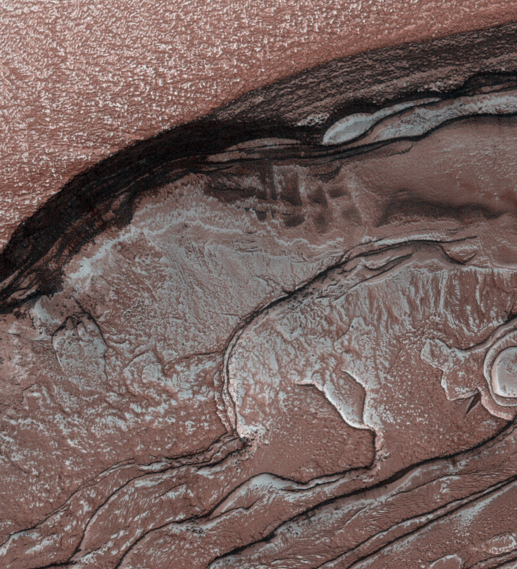
This view from NASA's Mars Exploration Rover Opportunity shows an area where a pale-toned geological unit called the "Burns Foundation," in the foreground, abuts a different geological unit. The darker unit, believed to be older, marks the edge of "Solander Point," a raised segment of the western rim of Endeavour Crater.

The rover team intends to study this geological contact area with Opportunity before driving the rover up onto Solander Point to examine rocks there. The point's north-facing slope offers an advantage for power output from rover's solar panels during the upcoming southern hemisphere winter.

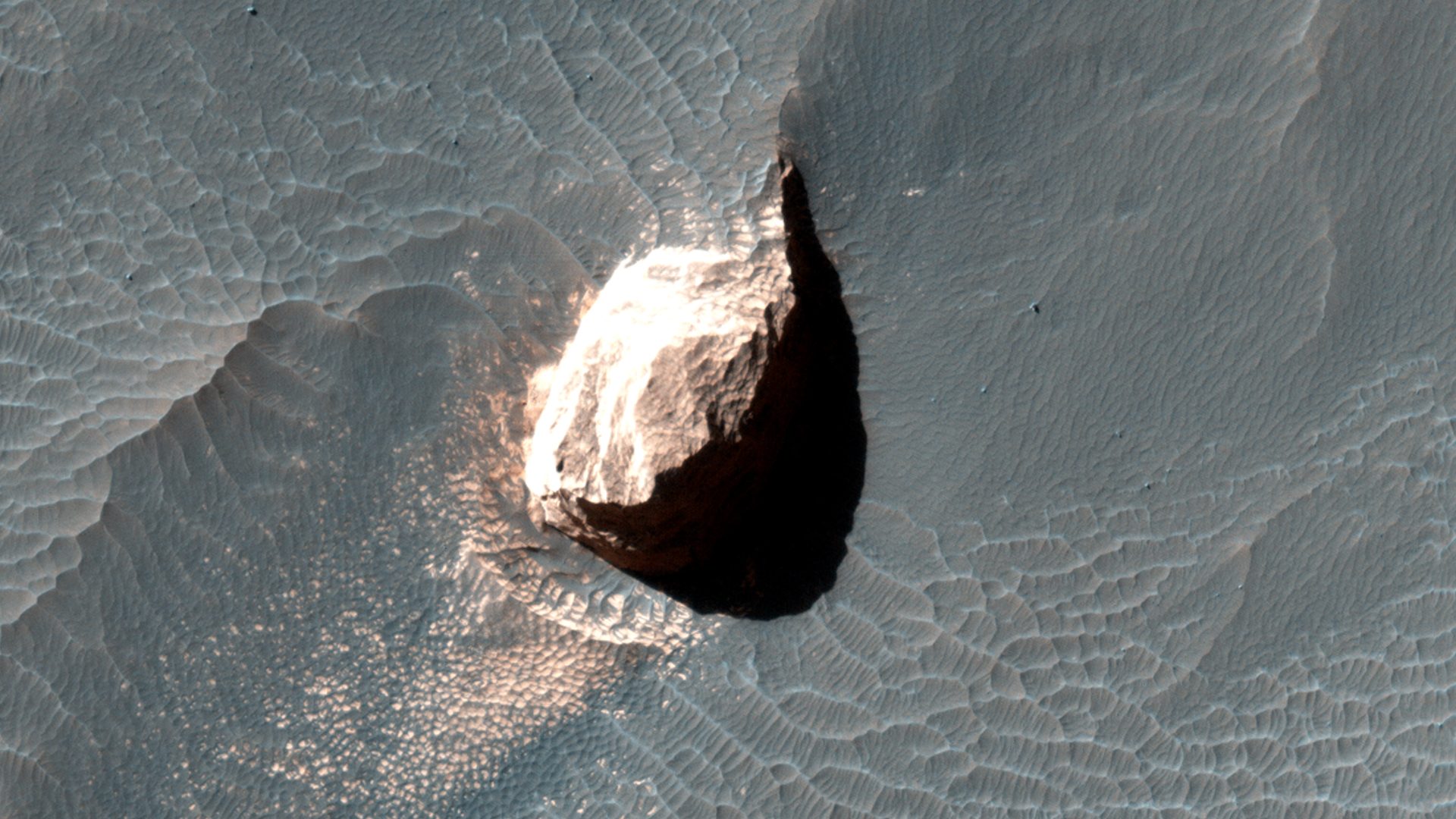
Opportunity used the navigation camera (Navcam) on its mast to capture this southward facing scene along the eastern flank of Solander Point during the 3,387 Martian day, or sol, of the rover's work on Mars (August 3, 2013).

The rock at the far right-hand side of the scene, informally named "Tick Bush," is about 1 foot (30 centimeters) across. In the week after this image was taken, Opportunity used tools on the rover's robotic arm to examine textures and composition of Tick Bush. The larger rock near the center of the image is informally named "Cheese Tree."

Photo credit: NASA/JPL-Caltech

Note: For more information, see Mars Rover Opportunity Working at Edge of 'Solander'.

Thursday, August 15, 2013

Possible Cyclic Bedding within a Crater in Arabia Terra


This observation covers an outcrop of possible cyclic bedding within a crater in Arabia Terra.

"Cyclic bedding" refers to a pattern of layering caused by repeated fluctuations in the amount of available sediment that creates new rock layers. These fluctuations are caused by long-term changes in the region's climate, with periods on the order of millions, or possibly hundreds of millions of years. It's possible that even the wobble of the planet might be a contributing factor to cyclic bedding.

An image at HiRISE resolution can help evaluate the cyclicity of the beds, as well as test possible regional stratigraphic correlations, and perhaps, indications of a wetter past environment.

This is a stereo pair with ESP_019347_1890.

Photo credit: NASA/JPL/University of Arizona

Wednesday, August 14, 2013

Landslide in Margaritifer Terra


This small landslide deposit is located in an unnamed crater in Margaritifer Terra.

Orbit Number: 51009 Latitude: -18.9654 Longitude: 344.961 Instrument: VIS Captured: 2013-06-14 01:07

Photo credit: NASA/JPL/Arizona State University

Polygonal Surface Patterns at the Martian South Pole


Like Earth, Mars has concentrations of water ice at both poles. Because Mars is so much colder, however, the seasonal ice that gets deposited at high latitudes in the winter and is removed in the spring (generally analogous to winter-time snow on Earth) is actually carbon-dioxide ice. Around the South Pole there are areas of this carbon dioxide ice that do not disappear every spring, but rather survive winter after winter. This persistent carbon-dioxide ice is called the "South Polar residual cap."

The white portions of this observation are part of that residual ice cap, and the sunlight is coming from roughly the bottom of this non-map projected image. It is made of solid, frozen carbon dioxide and is very bright relative to the background. This is despite the background terrain having a very high water-ice content, which is darkened by very fine rocky particles, or dust.

Very interesting and picturesque in this scene are the different scales of polygons present in each terrain. The relatively medium-toned lines in the dark terrain divide it into polygons that are up to approximately 10 to 15 meters (30 to 45 feet) wide. Typically, temperature changes of the ground over the seasons cause it to expand and contract, forming cracks and troughs between sections of ground that may partially fill with frost, forming the polygonal pattern viewed from above.

The polygons in the bright carbon dioxide terrain are different. First, they are much larger, up to 20 to 40 meters (60 to125 feet) wide. Second, they are (in most cases) traced out by thin ridges rather than narrow troughs. In rare cases there appears to be a trough where a ridge might be expected, attesting to the complicated patterns that develop in a type of ice that doesn't occur naturally on Earth (meaning, solid carbon dioxide) under conditions that are greatly different from our planet: very cold and very low pressure.

Photo credit: NASA/JPL/University of Arizona

Tuesday, August 13, 2013

Channel in Terra Sabaea


The small channel at the top of this VIS image is located on the rim of an unnamed crater in Terra Sabaea.

Orbit Number: 50995 Latitude: -24.3698 Longitude: 27.795 Instrument: VIS Captured: 2013-06-12 21:30

Photo credit: NASA/JPL-Caltech/Arizona State University

Four Newly Named Features on Mars

From the USGS Astrogeology Science Center:

The Working Group for Planetary System Nomenclature has approved new names for four features on Mars: Electris Mons, Eridania Mons, Sirenum Mons, and Sirenum Tholus. For more information, see the Gazetteer of Planetary Nomenclature.

Hellas Planitia and the South Polar Ice Cap by MARSIS


A radar view of the southern highlands of Mars, captured by the Mars Advanced Radar for Subsurface and Ionospheric Sounding (MARSIS) instrument on ESA’s Mars Express. The radar track covers 5580 km and features the Hellas Basin at the far right, and the south polar ice cap with its associated layered deposits just left of center.

The gap to the left of the south pole is an artificial effect due to a distortion in the measurements; it does not correspond to any geological feature.

Image credit: ESA/NASA/JPL/ASI/Univ. Rome

Monday, August 12, 2013

Frost on the Chasma Boreale Scarp


Sunlight was just starting to reach the high northern latitudes in late winter when HiRISE captured this image of part of the steep scarps around portions of the North Polar layered deposits.

The sunlight is highly diffused by atmospheric scattering, with the sun less than 0.5 degrees above the horizon. This diffuse light gives the image a unique appearance, almost like a painting. The surface is entirely covered by carbon dioxide frost mixed with dust.

Photo credit: NASA/JPL/University of Arizona

Sunday, August 11, 2013

Thermokarst in Utopia Planitia


The Martian landscape often owes its existence to the influences of liquid water and ice. This observation shows a couple of landforms that may result from the loss of large amounts of ice from subsurface deposits: polygonal patterns of troughs and large scallop-shaped depressions. Collectively, such landforms are referred to as "thermokarst."

Cold ice is generally strong and supports the weight of overlying soil. But when ice is lost through melting or sublimation, the supported surface can subside or collapse into the gradually growing cavity left behind by the lost ice. The shapes of the resulting depressions can offer us with clues (and lingering questions) to the origin of the ice.

Under the proper climate conditions ice may form and seasonally accumulate in a honeycomb network of vertical fractures that appear when ice-rich soil contracts each winter. On Earth this form of subsurface ice is called an "ice wedge." Special conditions are needed for this ice to accumulate and develop into a large wedge, namely warm temperature and abundant surface water. A thick layer of thawed wet soil forms allowing water to percolate into the open contraction cracks within the permafrost beneath. Later, loss of this wedge ice, by for example sublimation, results in deep depressions marking the honeycomb network.

Likewise, the larger scallop depressions might point to a past climate of frozen ponds or local patches of windblown snow collected in hollows. These surface ice deposits could later be covered by the ever-shifting soils and dust. In either case, the currently bitter cold and dry climate of Mars is not conducive to forming either of these buried-ice forms. Therefore, these landforms point to a warmer, but still cold, climate in the geologic past.

Photo credit: NASA/JPL/University of Arizona

Saturday, August 10, 2013

Fracture in Arcadia Planitia


Today's VIS image shows a channel-like feature. This feature is actually a large fracture that cuts through a small highlands.

Orbit Number: 50927 Latitude: 31.344 Longitude: 167.122 Instrument: VIS Captured: 2013-06-07 08:53

Photo credit: NASA/JPL-Caltech/Arizona State University

Note: This fracture is located in Arcadia Planitia a short distance east of Adams Crater.

Bright Dunes in Syria Planum


This image shows curious bright deposits in Syria Planum, a high elevation region near the summit of the Tharsis rise.

Syria Planum has a history of surface changes documented in telescopic and low resolution orbital observations since the Viking era. The surface changes result from the relentless deposition and removal of bright dust, as the dust is transported by winds blowing from north to south across the rocky dark surface.

Isolated patches where thick dust deposits have accumulated can be identified in THEMIS night-time infrared observations. The dust deposits are cooler (darker) than the rocky surface both in daytime and at night. Our HiRISE image was centered on one of these cold spots to observe the interaction of the dust deposits with local topography.

Examining the image shows that the dust here has accumulated into linear arrays of broken ridges spaced about 50 meters apart, and extending from tens to hundreds of meters in length. Dust deposits are visible along the rim of the impact crater but much of the crater's ejecta deposits are strangely dust free.

At full resolution, the ridges appear to have a morphology that is clearly distinct from sand dunes and bright transverse aeolian ridges common elsewhere on Mars. Their steep faces are on the upwind side (in the present day wind regime), opposite to the sand dunes. The ridge crests are crenulated, suggesting that the deposits are currently being eroded by the wind. Fine layering is visible in the deposits, possibly indicating an alternation of dust and sand deposition.

Deposits such as these hint that while modern Mars is relatively benign, the surface of the planet was battered by much more ferocious winds in the recent past, perhaps during periods of high obliquity.

Photo credit: NASA/JPL/University of Arizona

Friday, August 9, 2013

Fractures in Gorgonum Chaos


Several fractures cross through Gorgonum Chaos in this VIS image.

Orbit Number: 50827 Latitude: -38.1121 Longitude: 188.825 Instrument: VIS Captured: 2013-05-30 01:48

Photo credit: NASA/JPL-Caltech/Arizona State University

Thursday, August 8, 2013

Dunes in Aonia Terra


This VIS image shows small sets of dunes on the plains of Aonia Terra.

Orbit Number: 50825 Latitude: -46.8769 Longitude: 244.778 Instrument: VIS Captured: 2013-05-29 21:54

Photo credit: NASA/JPL-Caltech/Arizona State University

Wednesday, August 7, 2013

Aeolian Erosion Near Aeolis Planum


The wind is responsible for the erosion seen in this VIS image near Aeolis Planum.

Orbit Number: 50816 Latitude: -6.83397 Longitude: 150.485 Instrument: VIS Captured: 2013-05-29 03:54

Photo credit: NASA/JPL-Caltech/Arizona State University

Tuesday, August 6, 2013

Lava Flows in Southwestern Daedalia Planum


The volcanic flows in this image are at the far southwestern margin of Daedalia Planum.

Orbit Number: 50651 Latitude: -35.6702 Longitude: 222.955 Instrument: VIS Captured: 2013-05-15 14:12

Photo credit: NASA/JPL-Caltech/Arizona State University

Belyov, Reutov and Tyuratam Craters

From the USGS Astrogeology Science Center:

The Working Group for Planetary System Nomenclature has approved new names for three craters on Mars: Belyov, Reutov, and Tyuratam. For more information, see the Gazetteer of Planetary Nomenclature.

Twin Cairns Island


This scene combines seven images from the telephoto-lens camera on the right side of the Mast Camera (Mastcam) instrument on NASA's Mars rover Curiosity. The component images were taken between 11:39 and 11:43 a.m., local solar time, on 343rd Martian day, or sol, of the rover's work on Mars (July 24, 2013). That was shortly before Curiosity's Sol 343 drive of 111 feet (33.7 meters). The rover had driven 205 feet (62.4 meters) on Sol 342 to arrive at the location providing this vista. The center of the scene is toward the southwest.

A rise topped by two gray rocks near the center of the scene is informally named "Twin Cairns Island." It is about 100 feet (30 meters) from Curiosity's position. The two gray rocks, combined, are about 10 feet (3 meters) wide, as seen from this angle.

This mosaic has been white-balanced to show what the scene would look like under Earth lighting conditions, which is helpful in distinguishing and recognizing materials in the rocks and soil.

Photo credit: NASA/JPL-Caltech/Malin Space Science Systems

Note: For more information, see NASA's Curiosity Nearing First Anniversary on Mars.

Monday, August 5, 2013

MSL Traversal Through August 1, 2013


The total distance driven by NASA's Mars rover Curiosity passed the one-mile mark a few days before the first anniversary of the rover's landing on Mars.

This map traces where Curiosity drove between landing at "Bradbury Landing" on August 5, 2012, PDT, (August 6, 2012 (Universal Time and EDT) and the position reached during the mission's 351st Martian day, or sol, (August 1, 2013). The Sol 351 leg added 279 feet (85.1 meters) and brought the odometry since landing to about 1.05 miles (1,686 meters).

The mapped area is within Gale Crater and north of the mountain called Mount Sharp in the middle of the crater. After the first use of the drill, the rover's main science destination will be on the lower reaches of Mount Sharp. For broader-context images of the area, see PIA16064 and PIA16058.

The base image from the map is from the High Resolution Imaging Science Experiment Camera (HiRISE) on NASA's Mars Reconnaissance Orbiter.

Image credit: NASA/JPL-Caltech/University of Arizona

Curiosity's First Twelve Months in Two Minutes


Here is a rover's eye view of driving, scooping and drilling during Curiosity's first year on Mars, August 2012 through July 2013. This animation combines 556 frames taken by NASA's Mars rover's Hazard-Avoidance camera (Hazcam).

Video credit: NASA/JPL-Caltech

Sunday, August 4, 2013

Gale Crater Interior


NASA's Mars rover Curiosity used the Navigation Camera (Navcam) on its mast to record this westward look on the 347th Martian day, or sol, of the rover's work on Mars (July 28, 2013). The rover had completed a southwestward drive of 60.1 meters on that sol.

The prominent rock in the right foreground, informally named "East Bull Rock," is about 20 inches (half a meter) high. The rock-studded local rise dominating the image is called "Elsie Mountain." A distant portion of the rim of Gale Crater is visible in the upper portion of the view.

Photo credit: NASA/JPL-Caltech

Tagus Valles


In the ancient cratered southern highlands of Mars, the faint traces of a wet past are seen in the form of channels (lower center), fluidized debris around craters (bottom right) and blocks of eroded sediments (top left). Volcanic activity may have deposited the fine dusting of dark material visible in the top left.

The image was taken by the High Resolution Stereo Camera on ESA’s Mars Express on 15 January 2013 (orbit 11504), with a ground resolution of approximately 22 m per pixel. The image center lies at about 4°S / 114°E, close to Tagus Valles in an unnamed region north of Hesperia Planum.

Photo credit: ESA/DLR/FU Berlin (G. Neukum)

Note: For more information, see Tagus Valles Topography and Tagus Valles 3D.

Saturday, August 3, 2013

Daedalia Planum


The extensive volcanic flows in this VIS image are part of Daedalia Planum.

Orbit Number: 50613 Latitude: -21.1694 Longitude: 240.671 Instrument: VIS Captured: 2013-05-12 11:00

Photo credit: NASA/JPL-Caltech/Arizona State University

Flooded Crater in Tagus Valles


This close-up perspective view focuses on the craters in the center of the main color image. Here, a smaller crater clearly overlies the older, larger crater. To the right in this orientation lies a heavily deformed crater. Nearby, a channel appears to flow from the crater – perhaps this once transported water and sediments from a crater lake.

Photo credit: ESA/DLR/FU Berlin (G. Neukum)

Friday, August 2, 2013

Kaiser Crater Dunes


This daytime IR image shows part of the dune field on the floor of Kaiser Crater. The dune sand is warmer than the surrounding materials, so it appears bright in the IR image.

Orbit Number: 50658 Latitude: -46.8214 Longitude: 19.182 Instrument: IR Captured: 2013-05-16 04:05

Image credit: NASA/JPL-Caltech/Arizona State University

Landslides Within a Crater


One of the deepest craters in the region of the main color image lies in the foreground of this perspective view. Numerous landslides have occurred within this crater, leaving grooves in the crater wall as material slumped to the floor below.

Photo credit: ESA/DLR/FU Berlin (G. Neukum)

Thursday, August 1, 2013

Reull Vallis


This VIS image shows a small section of Reull Vallis.

Orbit Number: 50555 Latitude: -39.7059 Longitude: 109.896 Instrument: VIS Captured: 2013-05-07 16:37

Photo credit: NASA/JPL-Caltech/Arizona State University