Wednesday, July 25, 2012

Tyrrhena Terra


The 1000 × 2000 km area region of Tyrrhena Terra (outlined by the white box in the inset) sits between two regions of low altitude – Hellas Planitia and Isidis Planitia – in Mars' southern hemisphere, as shown in this global topography map. Hydrated minerals were found in 175 locations associated with impact craters in Tyrrhena Terra, such as inside the walls of craters, along crater rims, or in material excavated by the impact. Analysis suggests that these minerals were formed in the presence of water that persisted at depth for an extended period of time.

Map credit: NASA/MOLA Science Team/D. Loizeau et al.

Sunday, July 22, 2012

Streaks on the North Polar Layered Deposits


This image shows an exposure of the north polar layered deposits with strange streaks superimposed on the layers.

These streaks may be formed by winds blowing bright water frost over the surface, removing frost from the surface, or blowing dark material over the frost. These streaks make it a bit more difficult to see the angular unconformity running from upper left to lower right. The unconformity can be traced by finding where the layers at the top of the image are truncated by the layers at the bottom of the image.

This relationship shows that the layered deposits were eroded in this area, probably thousands to millions of years ago, before younger layers were deposited over them. The streaks over them were formed during the current northern summer, and may not persist for long.

Photo credit: NASA/JPL/University of Arizona

Saturday, July 21, 2012

Active Sand Abrasion in the Northern Polar Region of Mars


The large dune field which surrounds Mars' North Polar cap is actively being modified by the wind, with dunes moving at rates of a meter or more per year (PDF). This new HiRISE image shows that the blowing sand is also abrading the ice-rich ground over which the dunes migrate.

Clearly visible in the black and white and color HiRISE frames is a linear texture on the interdune surface that is oriented north-northeast to south-southwest. This orientation matches that of the horns and slipfaces of the barchan dunes, which together indicate migration from the north-northeast to the south-southwest. Visible here are four zoomed views that provide details of this texture. Zoom A/blue box shows a typical barchan dune. The linear texture is visible, albeit subtly, on the surrounding ground surface.

The texture is more apparent in the next views: A zoom of an interdune surface (Zoom B/red box) shows the wind-etched topography as a series topographic high and lows, with the directional trend indicated by the white arrows. This is also clearly seen next to another dune (Zoom C/yellow box). Further zooming in shows that the topographic highs contain boulders, which may be ice rich (Zoom D/orange box). Most of the sand abrasion probably occurs within the topographic troughs, accentuating topography and abrading away boulders, leaving remnant rocks on the highs. This shows that sand abrasion is actively modifying the surface in Mars' northern latitudes.

This is a stereo pair with ESP_027248_2550.

Photo credit: NASA/JPL/University of Arizona

Friday, July 20, 2012

Layered Material Cut by a Valley Connected to East Jezero Crater


This image shows layered bedrock composed of light- and intermediate-toned materials. There are also darker bed forms that fill in low-lying topography, such as impact craters.

In the center of the image is a valley with darker fill extending from left to right. The darker materials within the valley might be fluvial sediments. At HiRISE resolution, we might be able to decipher the properties of the bedrock as well as what deposited the sediments.

Photo credit: NASA/JPL/University of Arizona

Thursday, July 19, 2012

Wavy-Looking Layers in the North Polar Layered Deposits


These layers near the North Pole of Mars probably record global climate changes, similar to ice ages on Earth.

They appear wavy here either because flat-lying layers have been eroded into shallow valleys and ridges, or because the layers are not horizontal. Some of these layers are truncated, or appear to pinch out against other layers, evidence of a period of erosion followed by continued deposition of new layers.

The orientations of both the wavy-looking layers and the "unconformity" or erosional surface will be determined once this image and its stereo pair have been used to measure the surface topography.

This is a stereo pair with ESP_026662_2625.

Photo credit: NASA/JPL/University of Arizona

Note: This image is located in the Gemini Scopuli region of Planum Boreum; the closest named feature to this location is Udzha Crater, to the southeast.

Wednesday, July 18, 2012

Flows in Hellas Planitia


Hellas Planitia is the interior of the Hellas impact basin, is one of the largest visible impact craters in the Solar System. Hellas is located in the Southern highlands and formed very early in the planet's history. The floor of Hellas includes the lowest elevations on Mars and some of the strangest landscapes.

The most striking feature of this observation are the incredible banded features, probably due to the flow of surface material. Although Martian flow features may have Earth analogs such as rock glaciers, it's uncertain as to what types of fluvial, glacial and mass-wasting processes are involved in their formation.

This is a stereo pair with ESP_017644_1420.

Photo credit: NASA/JPL/University of Arizona

Tuesday, July 17, 2012

Geological Diversity at Curiosity's Landing Site


The area where NASA's Curiosity rover will land on August 5 PDT (August 6 EDT) has a geological diversity that scientists are eager to investigate, as seen in this false-color map based on data from NASA's Mars Odyssey orbiter. The image was obtained by Odyssey's Thermal Emission Imaging System. It merges topographical data with thermal inertia data that record the ability of the surface to hold onto heat.

The yellow oval shows the elliptical landing target for Curiosity's landing site.

An alluvial fan is visible around a crater to the northwest of the landing area. A series of undulating lines traveling southeast from the crater indicates similar material moving down a slope. The material, which appears bluish-green in this image, also forms a fan shape.

An area in red indicates a surface material that is more tightly cemented together than rocks around it and likely has a high concentration of minerals. An attractive interpretation for this texture is that water could have been present there some time in the past.

Curiosity is expected to land within the large Gale Crater. The rim of a smaller crater (about a half mile, or 1 kilometer, in diameter) inside of Gale is visible at the bottom right of the image.

Map credit: NASA/JPL-Caltech/Arizona State University

Note: For more information, see NASA's Car-Sized Rover Nears Daring Landing on Mars

Monday, July 16, 2012

Gully Monitoring on Crater Slopes in Terra Sirenum


These crater gullies lie on the northern wall of an unnamed 9-kilometer diameter southern hemisphere crater in Terra Sirenum. The image was acquired during early winter in the southern hemisphere, so the crater wall is in shadow.

These gullies were first imaged by HiRISE in 2006. Since that time the possible role of seasonal frost in gully formation along with the association of polygonal terrain with these and other gullies has garnered considerable interest. As a result, these gullies have become one of several locations being monitored by HiRISE throughout multiple Mars years. Over a dozen images of these gullies have been acquired to date throughout different Mars seasons.

In this image, frost (likely water-ice) is once again forming on these southern hemisphere mid-latitude crater slopes. The subimage shows gullies on the shadowed polar-facing slope. The large dynamic range of the HiRISE camera allows one to see into the shadows dimly lit by sunlight scattered by the surface and the atmosphere. These gullies are thinly veiled with frost and range in width from several meters to tens of meters and in length from a couple kilometers or so. Dark regions within the gullies are warmer areas where frost likely evaporated or melted exposing the darker underlying surface.

Photo credit: NASA/JPL/University of Arizona

Sunday, July 15, 2012

Frosted Gullies in Newton Crater


This image shows a crater wall in the southern hemisphere, with gully landforms.

Gullies like these are mostly found in the mid-latitudes, between 30-50 degrees north or south. In the Martian winter, frost (mostly carbon dioxide) can build up in the gullies, especially on the cold slopes that face the pole.

The bright, bluish (enhanced-color) frost can be clearly seen in the upper alcoves of gullies here. We now know that Martian gullies are active, and that most changes occur in the winter--it is likely that frost like this causes the activity in some way.

Photo credit: NASA/JPL/University of Arizona

Note: This landscape is located on the eastern wall of Newton Crater. The Mars 3 landing site is located to the southwest of this location.

Saturday, July 14, 2012

A Fading Impact Crater in Lucus Planum


This cluster of craters formed quite recently from a weak impactor that broke apart in Mars' thin atmosphere before smashing into the surface. It was discovered by the MRO Context Camera (CTX) Team, who found a dark spot in a CTX image taken in August 2008 that was not present in earlier Mars Odyssey Mission THEMIS images from July 2005. HiRISE examined the feature in October 2008 and verified that the dark spot was impact ejecta excavated from beneath the bright surface.

On June 25 2012, HiRISE took another look at the young crater to see how it had fared after two Martian years. This image was timed to closely match the illumination and viewing conditions of the earlier HiRISE image. A comparison of the two images shows that the dark halo surrounding the crater cluster has nearly vanished. The delicate rays extending beyond the halo are also significantly faded. Only the individual craters remain distinctly dark in the new image.

This observation is important for two reasons. First, it raises questions about the Martian winds and sediments that produce such changes. Did the dark ejecta blow away, or was it buried by a layer of bright dust? Second, it tells us that the window for detection of these young craters can be very short. In this case, the dark spot that drew the attention of the Context Camera Team was the 200-meter diameter halo of ejecta that encircled the crater cluster. After two Martian years, the halo is gone and the impact cluster would not be easily detected.

Photo credit: NASA/JPL/University of Arizona

Note: This feature is located in Lucus Planum to the west of Memnonia Sulci.

Friday, July 13, 2012

Ridges in Meridiani Planum


When terrain gets squeezed by geologic forces, deep rocks sometimes break and get pushed upwards forming raised wrinkles on the surface. These wrinkle ridges are common on a lot of planets including Mars.

One of these ridges exists south of this image but seems to have been buried there. With HiRISE, we might be able to figure out the sequence of events by comparing the topography of the ridge with the younger layer that buries it.

Meridiani Planum is famous for another reason. This is where the rover Opportunity landed and has been exploring since 2004.

This is a stereo pair with ESP_025663_1800.

Photo credit: NASA/JPL/University of Arizona

Thursday, July 12, 2012

Antoniadi Crater


Some of of the challenges of exploring Mars is not only finding a safe landing spot for a future rover, but a place that is scientifically compelling as well.

HiRISE has taken scores of observations for other missions like Phoenix and the Mars Science Laboratory to help those science teams better understand possible terrain hazards. In this observation, we are trying to explore for the presence of minerals called quartz and feldspar, which are even more common on Earth than Mars.

Antoniadi Crater was identified, even prior to the MRO mission, as a likely ancient lake (now dry) that was supplied by both surface water and ground water. Note also how "flat" the terrain appears, an important factor for any potential landing spot.

Photo credit: NASA/JPL/University of Arizona

Wednesday, July 11, 2012

Rough Surfaces in Deuteronilus Mensae


The objective of this observation is to examine what may be formerly ice-rich terrain that has just lost ice to the atmosphere.

Research with the Shallow Radar instrument onboard the Mars Reconnaissance Orbiter has found that many areas in Deuteronilus Mensae are glaciers with a thin layer of debris on top of them. This image may show a transition from ice-rich to ice-poor terrain.

Removal of buried ice can cause collapse and may be responsible for the strange appearance of this terrain. Understanding the origin of features in this image tells us something about when buried ice was stable or unstable and therefore helps us figure out how the climate of Mars has changed.

Photo credit: NASA/JPL/University of Arizona

Tuesday, July 10, 2012

Colorful Layers in Nili Fossae


This enhanced-color version of the central part of the HiRISE image shows colorful layers that may contain carbonate minerals.

Carbonates are commonly formed on Earth by marine organisms; the origin of these carbonates on Mars is unknown, but probably involved liquid water.

This image was taken along with the CRISM instrument, also onboard MRO, in what is called "ridealong" mode.

Photo credit: NASA/JPL/University of Arizona

Notes: This picture was taken in the Nili Fossae area to the northeast of Hargraves Crater. For the Spanish translation of this page, see Estratos de Colores en Nili Fossae.

Monday, July 9, 2012

Sinuous Ridges in Aeolis Planum


In this image, we see several very sinuous ridges, some very eroded, and others still very well defined.

The eroded ridges are located in a trough, while the well-preserved ridges are at higher elevation. The image allows scientists to characterize the morphology and the local texture of both type of ridges and determine whether those where part of the same network or where formed at two different stratigraphic levels, during different fluvial episodes.

This is a stereo pair with ESP_026818_1740.

Photo credit: NASA/JPL/University of Arizona

Sunday, July 8, 2012

Two Craters in Terra Sabaea: Which Came First?


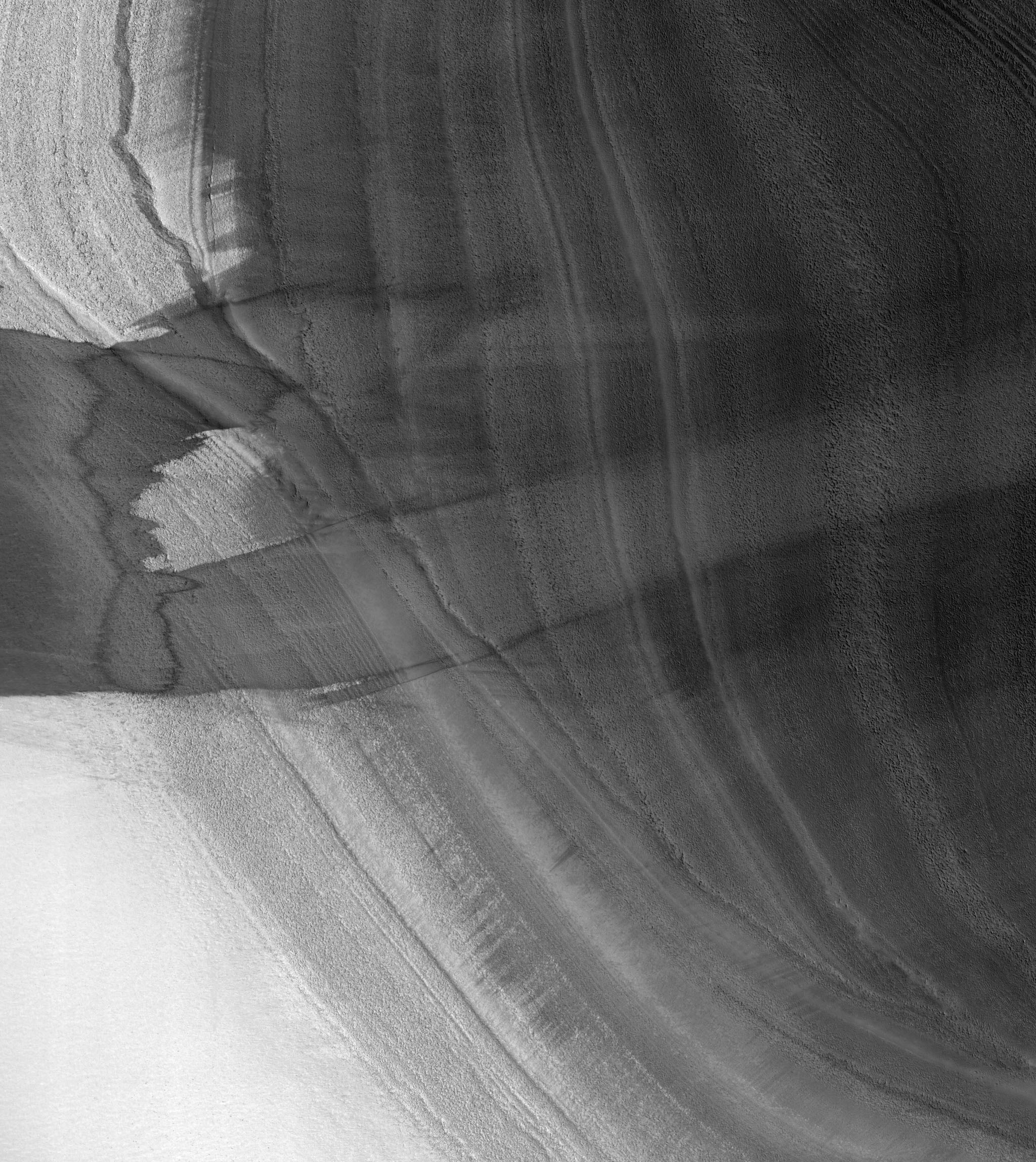
This image shows two craters, both approximately the same diameter (not quite 3 kilometers, or about 1.8 miles), but quite different in appearance otherwise.

The slightly smaller crater to the south seems to have a sharper rim and steeper sides than its partner to the north, which also appears to contain more small craters inside it and along its rim. The interior of the northern crater, in particular its south-facing wall, appears to have a similar texture to the ejecta around the southern crater. This is the second image in a stereo pair (the first is ESP_019346_1690), so we have an anaglyph of these craters.

Although it would require a digital terrain model and more analysis to be certain, in the anaglyph it appears that the southern crater has a higher rim and a deeper center than the northern crater. All these signs point to the northern crater being quite a bit older than the southern crater, rather than the two craters forming in the same impact event. For an example of two craters that might have formed at the same time (see ESP_020894_1395).

Compare the similarity of those two craters with the disparate appearance of the ones in this image.

This is a stereo pair with ESP_019346_1690.

Photo credit: NASA/JPL/University of Arizona

Note: This image is located in southwestern Terra Sabaea, near the Noachis Terra border. The closest named feature is Pollack Crater, which is a short distance to the north.

Saturday, July 7, 2012

Greeley Haven Panorama


This full-circle scene combines 817 images taken by the panoramic camera (Pancam) on NASA's Mars Exploration Rover Opportunity. It shows the terrain that surrounded the rover while it was stationary for four months of work during its most recent Martian winter.

Opportunity's Pancam took the component images between the 2,811th Martian day, or sol, of the rover's Mars surface mission (December 21, 2011) and Sol 2,947 (May 8, 2012). Opportunity spent those months on a northward sloped outcrop, "Greeley Haven," which angled the rover's solar panels toward the sun low in the northern sky during southern hemisphere winter. The outcrop's informal name is a tribute to Ronald Greeley (1939-2011), who was a member of the mission team and who taught generations of planetary scientists at Arizona State University, Tempe. The site is near the northern tip of the "Cape York" segment of the western rim of Endeavour Crater.

North is at the center of the image. South is at both ends. On the far left at the horizon is "Rich Morris Hill." That outcrop on Cape York was informally named in memory of John R. "Rich" Morris (1973-2011), an aerospace engineer and musician who was a Mars rover team member and mission manager at NASA's Jet Propulsion Laboratory, Pasadena.

Bright wind-blown deposits on the left are banked up against the Greeley Haven outcrop. Opportunity's tracks can be seen extending from the south, with a turn-in-place and other maneuvers evident from activities to position the rover at Greeley Haven. The tracks in some locations have exposed darker underlying soils by disturbing a thin, bright dust cover.

Other bright, dusty deposits can be seen to the north, northeast, and east of Greeley Haven. The deposit at the center of the image, due north from the rover's winter location, is a dusty patch called "North Pole." Opportunity drove to it and investigated it in May 2012 as an example of wind-blown Martian dust.

The interior of Endeavour Crater can been seen just below the horizon in the right half of the scene, to the northeast and east of Cape York. The crater spans 14 miles (22 kilometers) in diameter.

Opportunity's solar panels and other structures show dust that has accumulated over the lifetime of the mission. Opportunity has been working on Mars since January 2004.

During the recent four months that Opportunity worked at Greeley Haven, activities included radio-science observations to better understand Martian spin axis dynamics and thus interior structure, investigations of the composition and textures of an outcrop exposing an impact-jumbled rock formation on the crater rim, monitoring the atmosphere and surface for changes, and acquisition of this full-color mosaic of the surroundings.

The panorama combines exposures taken through Pancam filters centered on wavelengths of 753 nanometers (near infrared), 535 nanometers (green) and 432 nanometers (violet). The view is presented in false color to make some differences between materials easier to see.

Photo credit: NASA/JPL-Caltech/Cornell/Arizona State University

Note: For more information, see Mars Panorama: Next Best Thing to Being There.

Friday, July 6, 2012

Melas Dorsa


High-Resolution Stereo Camera (HRSC) nadir and color channel data taken during revolution 10532 on 17 April 2012 by ESA’s Mars Express have been combined to form a natural-color view of the Melas Dorsa region. Centered at around 18°S and 288°E, this image has a ground resolution of about 18 m per pixel. The image shows the wrinkle ridges bisected by crustal displacement faults known as ‘en-echelon’ faults along with the large impact crater with its butterfly-shaped fluidized ejecta blanket. En-echelon faults are closely spaced, parallel overlapping or step-like fault structures, which in this view can be seen at the far left of the image, intersecting the wrinkle ridges.

Photo credit: ESA/DLR/FU Berlin (G. Neukum)