Monday, January 31, 2011

Galaxias Fossae


RUNNING STRAIGHT toward the horizon, Galaxias Fossae carves a line across Mars' Utopia plains. The channel formed in ground laden with ice and water when a ribbon of molten rock rose within a geologic fault. The heat triggered the escape of water, undermining the surface and creating a network of shallow channels. This view (which has no vertical exaggeration) looks west.

Photo credit: NASA/JPL/Arizona State University, R. Luk

Note: For more information, see Galaxias Fossae: The Fire Below.

Sunday, January 30, 2011

Cydonia's Mystery Mesa


SO WHERE'S THE ALIEN CIVILIZATION? The famous mesa formerly known as The Face lies in the foreground at right, where it is slowly eroding along with the other mesas in Cydonia. About 300 meters (1,000 feet) high, its north and east sides (seen here) are covered with "pasted-on terrain." This is the term geologists give to a mantle of material that may be ice-rich and which they think was deposited during the last Martian ice age, more than half a million years ago. This view looks south.

Photo credit: NASA/JPL/Arizona State University, R. Luk

Note: For more information, see Cydonia: Martian Mystery Region.

Saturday, January 29, 2011

Thursday, January 27, 2011

Linear Ridges in Meridiani Planum


Linear ridges are located in the topographic lows in this image located just north of Meridiani Planum. The ridges are likely caused by material that filled tectonic fractures which is more resistant to erosion than the surrounding materials. When the less resistant material is removed the ridges remain to mark the location of former tectonic fractures.

Photo credit: NASA/JPL/Arizona State University

Note: This image is located south of Marth Crater.

Wednesday, January 26, 2011

Monday, January 24, 2011

Lava Channels in Southern Elysium Planitia


Located on the southern part of the Elysium Mons Volcanic region the channels in this VIS image where likely formed by the flow of lava.

Photo credit: NASA/JPL/Arizona State University

Seasonal Changes in Northern Dunes


Three images of the same location taken at different times on Mars show seasonal activity causing sand avalanches and ripple changes on a Martian dune. Time sequence of the images progresses from top to bottom. Each image covers an area 285 meters (312 yards) by 140 meters (153 yards). The crest of a dune curves across the upper and left portions of the image.

The High Resolution Imaging Science Experiment (HiRISE) camera on NASA's Mars Reconnaissance Orbiter took these images. The site is at 84 degrees north latitude, 233 degrees east longitude, in a vast region of dunes at the edge of Mars' north polar ice cap [i.e., Olympia Undae]. The area is covered by carbon-dioxide ice in winter but is ice-free in summer. The top and bottom images show part of one dune about one Mars year apart, at a time of year when all the seasonal ice has disappeared: in late spring of one year (top) and early summer of the following year (bottom). The middle image is from the second year's mid-spring, when the region was still covered by seasonal carbon-dioxide ice.

Spring evaporation of the seasonal layer of ice is manifested as dark streaks of fine particles carried to the top of the ice layer by escaping gas. The bottom of the ice layer, in contact with the dark ground, warms faster than the top of the ice does in the spring. Carbon-dioxide gas produced by the thawing of the bottom ice is temporarily trapped under the top ice. As the ice evaporates from the bottom, flow of gas under the ice destabilizes the sand on the dune and causes the sand to avalanche down the dune slipface. A before-and-after comparison of the dune shows new alcoves and extension of the debris apron on the slipface of the dune caused by descending grains of sand. New wind ripples appear on the debris apron.

The top image is a portion of the HiRISE observation cataloged as PSP_008867_2640, taken on June 17, 2008.

The middle image is a portion of the HiRISE observation cataloged as ESP_016779_2640, taken on February 23, 2010.

The bottom image is a portion of the HiRISE observation cataloged as ESP_018427_2640, taken on July 2, 2010.

Photo credit: NASA/JPL-Caltech/University of Arizona

Sunday, January 23, 2011

Wind Effects East of Medusae Fossae


The pits at the top of this VIS image are created by the action of the wind.

Photo credit: NASA/JPL/Arizona State University

Note: This image is located east of Medusae Fossae.

Arkhangelsky Crater Dunes


This observation shows dunes on the floor of the large, degraded Arkhangelsky Crater in the southern hemisphere of Mars.

Most of the dunes visible in this observation are barchan dunes. On barchan dunes, the steep slip face is between two "horns" that point downwind. In this case the dunes tell us that the wind direction is approximately from South-Southeast to North-Northwest.

Dust devils that pass through this area strip dust off of the ground, leaving tracks. In this observation, the dust devil tracks are clearly visible on the dunes, but are much less obvious on the rocky crater floor. When the thin coating of bright dust that covers the dunes is removed from the relatively dark dunes by dust devils, there is a clear contrast between the newly clean dune surface and the rest of the dune.

Although it is difficult to see the dust devil tracks on the crater floor, if you look closely, you can actually follow tracks from a dune to the crater floor and even back onto another dune such as in this subimage which is approximately .75 kilometers (.46 miles) wide.

Photo credit: NASA/JPL/University of Arizona

Saturday, January 22, 2011

South Polar Layers


The south polar cap of Mars is comprised of alternating layers of ice and dust. The darker dust layers help show the layering, especially on steep slopes.

Photo credit: NASA/JPL/Arizona State University

Note: The location of this image is near the "source" of Chasma Australe. The dusty remains of numerous geysers can be seen throughout this photo.

Chain Gang


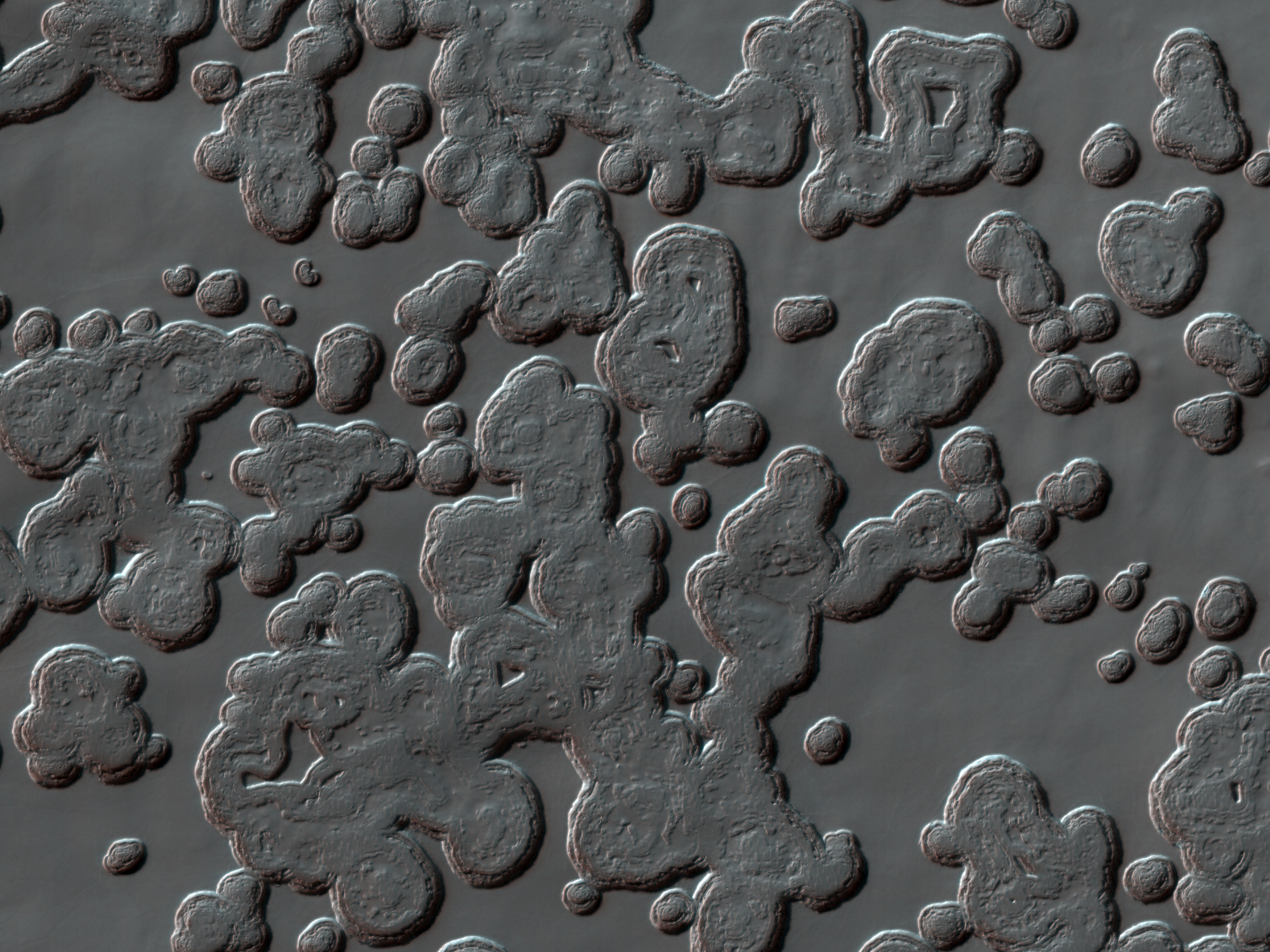
This chain of secondary craters just happened to be well-aligned with HiRISE's groundtrack (the path across the surface that a spot directly below the MRO spacecraft would trace out). Because of this favorable alignment, HiRISE was able to capture most of the chain in one 25 kilometer-long (15.6 mile) image.

Secondary craters occur during the formation of an impact crater. Impacts are very high-energy events, and while some rock gets melted or vaporized, other rock gets broken into large chunks and flung outward from the crater. Some of these pieces have enough energy to form small craters themselves when they reimpact the surface of Mars.

These craters can be of the same diameter as primary craters (those created directly from bodies entering the Martian atmosphere from space). In addition, primary crater clusters also exist (see examples like PSP_010200_1805, PSP_010292_1785, and ESP_017270_2265), leading to difficulties in determining the process responsible for creating a particular group of craters. One distinguishing feature of secondary craters is that they tend to be irregularly shaped, due to the lower velocity of crater ejecta.

Photo credit: NASA/JPL/University of Arizona

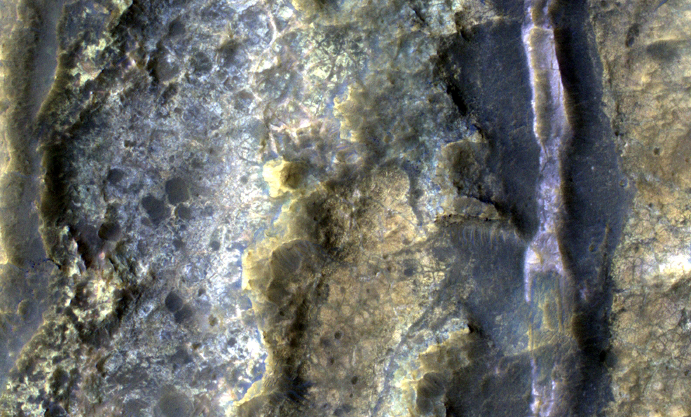
Note: This image is located inside the northwestern edge of Isidis Planitia.

Friday, January 21, 2011

Wind Erosion near Medusae Fossae


Constant sand-blasting by the winds on Mars have eroded and sculpted the surface in the equatorial region around Medusae Fossae.

Photo credit: NASA/JPL/Arizona State University

Paisley Terrain in Valles Marineris


Remember those paisley shirts during the summer of love in 1967? If so, this terrain may look somewhat familiar.

How did this terrain really form? One theory is that its a landslide deposit, perhaps associated with draining an ancient lake.

Photo credit: NASA/JPL/University of Arizona

Thursday, January 20, 2011

Eos Chasma


At the eastern end of Valles Marineris the chasma floors are typically filled with the hills and mounds of chaos terrain.

Photo credit: NASA/JPL/Arizona State University

Distinctive Rayed Impact Crater in Meridiani Planum


This "fresh" (very well-preserved) impact crater has created a radial pattern of dark rays. The image was suggested to address the question of why the rays are dark.

Is the crater so fresh and recent that there hasn't been time for bright dust to settle on the rays? That doesn't seem likely, as we can see windblown deposits inside the crater, which requires at least thousands of years to form after the impact event. Also, fresh craters with dark ejecta are common in Meridiani, and they can't all be extremely recent.

Did the crater eject a subsurface layer of dark material? Maybe, but all of the bedrock exposures in the surrounding region are relatively bright. The surface layer is darker than the bedrock because dark materials like hematite concretions ("blueberries" found by Opportunity rover) are resistant to wind erosion and get left as a lag deposit. At HiRISE scale the rays are seen to be a thin deposit, perhaps less than 1 meter thick.

The more distant ray segments contain many small secondary craters created by impact of rocks ejected from the primary crater. Maybe these are lag deposits from the original rays. In other words, a mix of broken-up target material was deposited, but the relatively bright materials have blown away since the crater formed. The darker sand or granule-sized materials might eventually be moved by the wind and trapped inside craters, as commonly seen over Meridiani Planum, but there hasn't been sufficient time since crater formation for this process to remove the rays.

The coarser particles might not be movable by wind in the current climate regime of Mars, but that changes over thousands and millions of years as Mars experiences periodic changes in orbital parameters such as tilt of the rotational axis. There has been some sand movement since the crater formed, since we see deposits inside the crater, but not enough to remove the rays.

Photo credit: NASA/JPL/University of Arizona

Wednesday, January 19, 2011

Swiss Cheese Terrain at Planum Australe


The pitted appearance of the south polar cap ice in this VIS image is similar to the appearance of a slice of swiss cheese.

Photo credit: NASA/JPL/Arizona State University

Canala Crater

From the USGS Astrogeology Science Center:

The name Canala has been approved for the Martian crater located at 24.35N, 80.0W. For more information, see the database information and the map of MC-10 in the Gazetteer of Planetary Nomenclature.

Note: Canala crater is a very small impact crater located at the western end of Nilus Chaos, which itself is along the northwestern boundary of Echus Chasma, a very long and major channel that ultimately fed Kasei Valles and Chryse Planitia.

The Textures of Santa Maria Crater


This image from NASA's Mars Exploration Rover at the edge of "Santa Maria" crater shows diverse textures of the crater. Contrast has been enhanced to emphasize the textures.

Opportunity used its navigation camera to record this view during the 2,476th Martian day, or sol, of the rover's work on Mars (January 10, 2011). The rover's position was close to the crater's lip on the southeastern edge of the crater. Santa Maria is about 90 meters (295 feet) in diameter.

Photo credit: NASA/JPL-Caltech

Note: For other pictures in this series, see PIA13756: View of 'Santa Maria' Crater from Western Rim, Sol 2454, PIA13757: View of 'Santa Maria' Crater from Western Rim, Sol 2454 (Stereo), PIA13758: View of 'Santa Maria' Crater from Western Rim, Sol 2454 (Polar), and PIA13759: View of 'Santa Maria' Crater from Western Rim, Sol 2454 (Vertical).

Tuesday, January 18, 2011

Melas Chasma


This VIS image shows the northern sidewall of Melas Chasma.

Photo credit: NASA/JPL/Arizona State University

Dusty Summit of Pavonis Mons


Pavonis Mons is one of the three giant Tharsis Montes shield volcanoes. Its summit rises so far above the surface that the atmosphere is extremely thin, even for Mars.

Dust that reaches these heights (for example, during major dust storms) is hard to remove, so the upper parts of these volcanoes are covered by vast deposits of dust. The dust is moved a little by the thin winds, producing ripples and other textures near the limit of HiRISE's resolution. The fluffy, ripply surface looks "smudged" or out of focus, but by looking at some of the small impact craters you can see that the HiRISE camera is, indeed, properly focused. It's the surface of Mars that is blurry!

The impact craters also show that the dust is not a thin veneer. Instead, it is a thick coat, at least several meters (yards) deep. This mantling of dust hides the details of the lava flows and vents, frustrating volcanologists but delighting those who study dust!

Photo credit: NASA/JPL/University of Arizona

Monday, January 17, 2011

Noctis Labyrinthus


Located at the westernmost end of Valles Marineris is the complexly fractured region called Noctis Labyrinthus. The canyon systems in Noctis Labyrinthus do not reach the depths of the chasma of Valles Marineris.

Photo credit: NASA/JPL/Arizona State University

Bright and Dark Plains near Ganges Chasma


This HiRISE image shows a mixture of bright and dark terrain along the plains just west of Ganges Chasma.

The concentration of these bright patches adjacent to an old impact crater suggests that the bright patches could represent ejecta from when the crater formed. This would be an interesting discovery because it would mean that a different unit underlies the surface we now see. Alternatively, much of the plains in this region appear to have a dark surficial cover, probably aeolian debris. Where this darker debris has been removed by the wind, the underlying brighter substrate would be exposed.

Mineralogic information from the CRISM instrument would be very useful for determining if the bright patches contain minerals indicative of water, such as clays, or if they are basalts produced from volcanic eruptions.

Photo credit: NASA/JPL/University of Arizona

Swiss Cheese Terrain


This image represents a Martian terrain containing "Swiss cheese" features. This terrain is found only within the residue of the southern polar cap, which comprises of mostly frozen carbon dioxide and water.

These particular features are flat-floored, circular depressions that are believed to form from different rates in the seasonal changes of the carbon dioxide and water ices. Varying rates in sublimation - when these ices change directly to vapors upon heat and back to deposited solids upon cooling - produces these rimmed depressions from the flat polar ice plane. It is hypothesized that the depression areas are made up of dry ice, carbon dioxide, and the material below consists of the water ice.

This carbon dioxide solid rises and slightly evaporates into the thin atmosphere in the summer while the water layer remains in place. As the south pole cools with seasonal change, the "Swiss cheese" formation is obtained with risen carbon dioxide rimmed depressions and flat water mesas. The Martian north pole will evaporate all of its carbon dioxide in the summer; however the south pole is colder and this may explain why this terrain is only found in this area.

Some of the circular features in the full image show distinct cusps that point in the direction of the pole. These cusps suggest insolation, a measure of solar radiation that is pushing the movement/formation of these depressions away from the pole. There is also an observed lateral outward growth of the features at the rate of about one-to-three meters a year, indicating to scientists that the depressions must form in a carbon dioxide medium.

Photo credit: NASA/JPL/University of Arizona

Sunday, January 16, 2011

Shadow of the Wind


Wind shadow and real shadow combine with an impact crater to produce a "comet." Winds blowing over the crater's rim have scoured the ground behind the crater free of light-colored dust, leaving exposed a relatively bare lava flow. The crater spans a width of about 3 kilometers (2 miles).

Photo credit: NASA/JPL/Arizona State University

Layering in Mawrth Vallis Crater


Mawrth Vallis has a rich mineral diversity, including clay minerals that formed by the chemical alteration of rocks or loose “regolith” (soil) by water. There is a high surface area of bedded phyllosilicate (clay) exposures (tens of kilometers), located in the bright-toned materials.

The CRISM instrument on the MRO spacecraft detects a variety of clay minerals here, which could signify different processes of formation. The high resolution of the HiRISE camera helps us to see and trace out layers, polygonal fractures, and with CRISM, examine the distribution of various minerals across the surface.

This surface is scientifically compelling for the Mars Science Laboratory (MSL) rover Curiosity and this region is one of four candidate landing sites for MSL.

Photo credit: NASA/JPL/University of Arizona

Saturday, January 15, 2011

Tigre Valles

From the USGS Astrogeology Science Center:

The name Tigre Valles has been approved for the Martian valley system located at 12S, 37W. For more information, see the database information and the map of MC-19 in the Gazetteer of Planetary Nomenclature.

Note: Tigre Valles is named after the Tigre River, which is a tributary of the Amazon River located in the country of Peru. Tigre Valles is located in the northeastern uplands south of Eos Chasma.

Bright Layers North of Meridiani Planum


This HiRISE image is located north of Meridiani Planum near the landing site of the Mars Exploration Rover Opportunity.

The surface adjacent to the edge of the crater is characterized by light-toned, regularly layered sedimentary rock, dark-toned material trapped in degraded crater floors, and knobs. The layered rocks are faulted (offset) in places and folded (see inset of false color image, 1 kilometer/0.6 miles across).

Photo credit: NASA/JPL/University of Arizona

Friday, January 14, 2011

Coprates Chasma


This VIS image shows a portion of Coprates Chasma.

Photo credit: NASA/JPL/Arizona State University

Light-Toned Mounds in Ganges Chasma


This formation of light-toned mounds on the floor of Ganges Chasma have been shaped by two erosional processes: landslides and wind.

The steeper sides of these mounds show a spur-and-gully shape which is indicative of down-slope mass movement and slope failures (little landslides). The "top" of the larger, center mound and other areas of the mounds show the streamlined forms of rock carved by eons of the wind at work.

You can also see the pattern of dark dunes that line the Ganges Chasma floor change as they interact with these mounds, showing a kind of parabolic exclusion zone along the east end of the mounds, indicating that the dominant wind direction is to the west.

These mounds are very similar to the much larger Ganges Mensa formation farther west in Ganges Chasma. These outcrops may in fact be an erosional remnant of a rock formation that filled the whole chasma, with Ganges Mensa being the biggest remnant and this and others being the only remaining outliers.

Photo credit: NASA/JPL/University of Arizona

Thursday, January 13, 2011

Wegener Crater Dunes


Located at 64 degrees South latitude, the dunes in Wegener Crater are just beginning to lose their frost cover. The 'salt and pepper' appearance is bright frost and dark dune on the crater floor.

Photo credit: NASA/JPL/Arizona State University

Russell Crater Dune Gullies


Russell Crater has a large field of dunes, including a mega-dune over 500 meters high.

This image was acquired in winter on Mars, when the dunes are covered with carbon dioxide ice (dry ice). The Sun has just come up, and is just 3 degrees above the horizon. At this low light level small ridges cast long shadows and the sides of channels facing the Sun are bright. This lighting emphasizes the troughs on the dunes and even small ripples can be detected.

Also apparent are "sublimation spots" that are caused by the evaporation of the dry ice. They will fade when the ice is gone.

Photo credit: NASA/JPL/University of Arizona

Wednesday, January 12, 2011

Russell Crater Dunes


This beautiful huge dune and associated smaller dunes are located on the floor of Russell Crater.

Photo credit: NASA/JPL/Arizona State University

Inverted Topography near Juventae Chasma


This image displays several nice examples of inverted channels near Juventae Chasma, part of the Valles Marineris system.

Inverted topography - when a feature that ordinarily would be lower in elevation than the surrounding terrain is instead higher in elevation - forms when low-lying features are filled with erosion-resistant materials (like lava, large rocks or cemented sediments). The softer surrounding material is more easily eroded, which results in the filled-in feature becoming a high spot instead of a dip.

In this image, the inverted relief preserves sinuous branching features, possibly ancient streambeds. And while it isn't exactly inverted topography, several of the craters in the image also seem to have been subject to a similar process - the erosion-resistant ejecta blankets stand higher than the surrounding terrain, forming an abrupt transition at the edge of the ejecta.

Photo credit: NASA/JPL/University of Arizona

Tuesday, January 11, 2011

Avernus Colles


This VIS image shows a portion of Avernus Colles. The term "colles" means small hills, and the surface here is being fractured into many small hills and mesas.

Photo credit: NASA/JPL/Arizona State University

Exclamation Mark on Mars


Turn this image sideways (so North is to the right) and the highstanding landforms look like an exclamation mark.

The origin of these hills may be difficult to understand on such ancient terrain. The straight edges suggest fractures related to faults. Maybe this feature was lifted up by the faulting, maybe the surrounding terrain has been eroded down over billions of years, or both.

Photo credit: NASA/JPL/University of Arizona

Note: This landform is located in Isidis Planitia, northwest of Du Martheray Crater.

Monday, January 10, 2011

Ius Chasma Landslide


Today's VIS image shows a portion of a large landslide deposit in Ius Chasma.

Photo credit: NASA/JPL/Arizona State University

Active Gullies on Martian Sand Dunes


The dark sand dunes here are eroded in many places, forming gullies. Some of these gullies were not present in prior images of this spot, or have grown in size.

Monitoring of dune gullies by HiRISE has shown us when the gullies are active: in the winter or early spring! This was a surprise, because the gullies look like ones on Earth that are formed by flowing water or wet debris.

It is far too cold for water to be liquid in the Martian winter, but there is carbon dioxide frost (dry ice) on the ground, lasting through the spring at high latitudes. This frost may serve to reduce grain-to-grain friction, allowing the sand to flow on the steep slopes.

Photo credit: NASA/JPL/University of Arizona

Note: These dune gullies are located in an impact crater in Noachis Terra, roughly halfway between Russell Crater and Kaiser Crater.

Sunday, January 9, 2011

The Mound in Gale Crater


A thick stack of sedimentary debris stands in Gale Crater, a possible target for exploration by NASA's Mars Science Laboratory. This view looks southwest, toward the crater's central peak in the left background.

Photo credit: NASA/JPL/Arizona State University, R. Luk

Note: For more information, see Gale Crater's History Book.

Ice-Rich Lobate Debris Aprons in Promethei Terra


This image shows a portion of a lobate debris apron along the bottom of a hill in the Promethei Terra region of Mars. This region contains many such mesas surrounded by lobate debris aprons that are thought to be ice-rich. These aprons have been interpreted as a variety of possible features including rock glaciers, ice-rich mass movements, or debris-covered glacial flows. Recent radar data have shown them to be composed of nearly 100% pure ice. Parallel grooves and ridges indicate the direction of flow.

Both the debris apron and the plains beyond it are blanketed with an ice-rich mantle that is common throughout the Martian mid-latitudes. The mantle deposits are pitted and grooved perhaps due to the sublimation of ice. This mantle is thought to have been deposited as snow around 10 million years ago during a period of high obliquity, when the planet's axis was more tilted and environmental conditions could have been more conducive to snowfall in these regions.

Several small impact craters are visible on the plains that appear to have been filled with mantling deposits that have subsequently been partially removed. These craters give us clues to the erosional history of the deposit.

Photo credit: NASA/JPL/University of Arizona

Note: This hill is located southwest of Pál Crater.

Saturday, January 8, 2011

Richardson Crater Dunes


These dunes in Richardson Crater are still frost covered. As spring deepens the frost will sublimate and the dark dunes will appear.

Photo credit: NASA/JPL/Arizona State University

Fan and Valley within Crater


This HiRISE image shows a fan-shaped deposit at the distal end of a valley. The fan is approximately 3.5 x 3.7 kilometers in size.

While other similar fans on Mars display stair-step terracing along their edges, this particular fan does not show any terraces. There is a valley to the upper left that is the source of material that now composes much of the fan.

Martian fans are thought to be either alluvial or deltaic in origin. On Earth, alluvial fans form when material upslope is eroded and transported by water down a confined valley until reaching a flatter, broader surface downslope where the material is deposited to produce a fan-shape.

Deltaic fans form when rivers transport sediment downstream until an unconfined and flatter surface is reached under water, at which time the sediment is deposited in a fan-shape. Whether the Martian fan formed by alluvial or deltaic processes in unknown, but both processes require a fluid (most likely water) that carved the valley and transported the sediment downstream.

Photo credit: NASA/JPL/University of Arizona

Note: This image is located in an unnamed impact crater just to the northwest of Becquerel Crater in Arabia Terra.

Friday, January 7, 2011

Planum Australe


It is early springtime in the southern hemisphere of Mars. The south polar cap is now illuminated by the Sun and we can study the surface as it changes with the passage of spring.

Photo credit: NASA/JPL/Arizona State University

Aerosols in the Air


HiRISE images are monochromatic across much of the scene, but in the center we return color data. The color strip down the center of this image gives us insight into aerosols (particles of dust and frost) suspended in the atmosphere and the seasonal processes that get them there.

In the winter Mars' south polar region is covered by a layer of carbon dioxide ice (dry ice). In the spring this ice evaporates from the top and the bottom of the seasonal ice layer (typically tens of centimeters thick). Where there are cracks in the ice the gas from below escapes, carrying fine particles from the surface up to the top of the ice. Larger particles fall back onto the ground in fan-shaped deposits pointing in a direction determined by the local winds.

We see the smaller particles (dust) suspended in the air locally over the cracks as the bluish tone over the regions with fans. Over regions without fans, where gas and dust from the surface are not escaping into the atmosphere, the surface is a more pinkish tone.

Photo credit: NASA/JPL/University of Arizona

Note: This image is located in Promethei Planum, which lies just north of Planum Australe.

Thursday, January 6, 2011

Wind Erosion in Gordii Dorsum


This ridge of material on the northern end of Gordii Dorsum is being reduced in size by the erosive effect of the wind.

Photo credit: NASA/JPL/Arizona State University

Thawing Richardson Crater Dunes


This image shows a portion of the dunes that fill Richardson Crater, a 55 kilometer diameter crater in the south polar region of Mars and a frequent repeat target for the HiRISE camera.

During southern fall and winter, these dunes are coated with seasonal carbon dioxide frost, which then sublimates (goes directly from a solid to a gas) into the atmosphere as the temperature rises in spring and summer.

The enhanced-color subimage shows a boundary between dunes that are mostly covered with seasonal frost and dunes that have mostly thawed. The color of many dunes on Mars can change dramatically depending on the season. Frost tends to be very bright in HiRISE images, particularly in the blue-green filter, but dune sand itself is very dark.

The dark streaks and spots on the frost-covered regions represent areas that are in the process of thawing out. In some areas, the frost has sublimated away. In others, a small avalanche of sand or dust may have spilled on top of the frost. Some of them may also be patches of coarse-grained ice that are relatively clear so that we can see the sand below. As spring advances toward summer in the south on Mars, these dunes continue to appear darker and more red to HiRISE.

Dunes near the polar regions of Mars are studied both by scientists who are interested in the effects of this seasonal cycle of thawing and frosting over, and by scientists who wait for the frost to disappear so that they can study the dunes themselves.

Repeat Target Images of Dunes
PSP_002041_1075, PSP_003175_1080, PSP_004006_1080, and PSP_004665_1080. These are images of the dunes from last Mars year.

Photo credit: NASA/JPL/University of Arizona

Wednesday, January 5, 2011

Channel in Tharsis


This channel is located within the Tharsis volcanic flows. It was most likely carved by the flow of molten lava.

Photo credit: NASA/JPL/Arizona State University

Note: This channel is located about halfway between the northern end of Ulysses Fossae and Jovis Tholus.

Small Valleys and Colorful Bedrock in Terra Cimmeria


This image shows a network of small valleys in the Terra Cimmeria region of the Martian southern highlands. This location is approximately 1,000 kilometers (600 miles) south of Gusev Crater, the landing site of the Mars Exploration Rover Spirit.

The valleys in this image are carved into light-toned bedrock exhibiting a range of colors, which likely reflect a range of mineralogical compositions. The bedrock is pervasively fractured, and some of the fractures appear to be filled with material of a different color, possibly composed of minerals that crystallized or were cemented together when fluids (perhaps water) circulated through the fractures.

On the right side of the subimage is a valley filled with dark material and a central, bright ridge. If the valley was carved by liquid water, then this ridge may mark a former stream channel where coarse-grained sediment was deposited, which has survived erosion more effectively than the finer-grained sediment in the valley outside the channel.

Similar “inverted channel” deposits are visible elsewhere on Mars, and some examples in the southern highlands have been inferred to contain chloride salts (similar to table salt). The color and texture of the possible inverted channels in this image are similar to those inferred to contain chlorides, which may have been deposited when salty water evaporated.

Considered together, the features in this image attest to a history of water-related activity at this location on Mars.

Photo credit: NASA/JPL/University of Arizona

Note: This image is located about halfway between Ariadnes Colles and the source of Ma'adim Vallis.

Tuesday, January 4, 2011

Panorama of Santa Maria Crater


A football-field-size crater, informally named "Santa Maria," dominates the scene in this 360-degree view from NASA's Mars Exploration Rover Opportunity.

Following a 25-meter (82-foot) drive on the 2,451st Martian day, or sol, of the rover's work on Mars (December 16, 2010), Opportunity used its navigation camera to take the frames combined into this mosaic. South is at the center. North is at both ends. The view is presented as a cylindrical projection.

Photo credit: NASA/JPL-Caltech

Note: For other photographs in this series, see: PIA13751: 'Santa Maria' Crater in 360-Degree View, Sol 2451 (Stereo), PIA13752: 'Santa Maria' Crater in 360-Degree View, Sol 2451 (Polar), and PIA13753: 'Santa Maria' Crater in 360-Degree View, Sol 2451 (Vertical).

Branched Features on the Floor of Antoniadi Crater


The dark branched features in the floor of Antoniadi Crater look like giant ferns, or fern casts. However, these ferns would be several miles in size and are composed of rough rocky materials.

A more likely hypothesis is that this represents a channel network that now stands in inverted relief. The channels may have been lined or filled by indurated materials, making the channel fill more resistant to erosion by the wind than surrounding materials. After probably billions of years of wind erosion the resistant channels are now relatively high-standing. The material between the branched ridges has a fracture pattern and color similar to deposits elsewhere on Mars that are known to be rich in hydrated minerals such as clays.

The inverted channels have short, stubby branches characteristic of formation by groundwater sapping. Spring water seeps into the channels and undercuts overlying layers which collapse, so the channels grow headward. These images tell the story of an ancient wet environment on Mars, where life could have been possible. Ancient Martian life was most likely to consist of microorganisms rather than giant tree ferns.

Photo credit: NASA/JPL/University of Arizona

Note: This image, along with this photo, forms an anaglyph image that can be found here.