Saturday, September 20, 2014

Swiss Cheese Terrain in Planum Australe


Today's polar image shows an unusual surface texture. The circular depressions look like Swiss cheese.

Orbit Number: 56475 Latitude: -86.65 Longitude: 355.117 Instrument: VIS Captured: 2014-09-06 21:13

Photo credit: NASA/JPL-Caltech/Arizona State University

Friday, September 19, 2014

Planum Australe


Today's VIS image shows a small part of the south polar cap.

Orbit Number: 56419 Latitude: -86.7159 Longitude: 160.247 Instrument: VIS Captured: 2014-09-02 06:34

Photo credit: NASA/JPL-Caltech/Arizona State University

Hooke Crater and Argyre Planitia


Color-coded topography map of a region of the Argyre basin, featuring Hooke crater and part of the floor of the basin known as Argyre Planitia. White and red show the highest terrains, while blue and purple show the deepest. The image is based on a digital terrain model of the region, from which the topography of the landscape can be derived. The region clearly slopes to the south (left).

The image was acquired by the High Resolution Stereo Camera on Mars Express on 20 April 2014 during orbit 13,082. The ground resolution is about 63 m per pixel. Hooke crater is located at about 46°S / 316°E. North is right and East is down.

Image credit: ESA/DLR/FU Berlin

Thursday, September 18, 2014

Layered Deposits at Planum Australe


Spring has arrived at the south pole of Mars. The multitude of layers that make up the cap are readily visible in today's THEMIS VIS image.

Orbit Number: 56290 Latitude: -84.0207 Longitude: 220.827 Instrument: VIS Captured: 2014-08-22 15:42

Photo credit: NASA/JPL-Caltech/Arizona State University

Overlapping Lobate Lava Flows in Daedalia Planum


Lava flows south of Arsia Mons in Daedalia Planum transition from younger flows with elongated, sinuous morphologies to the northeast, to older, broader lobes and sheet flows to the southwest. (The time scale we’re talking about is approximately 100 million to 1 billion years.) At the southern margin of the Tharsis region, older, probably 3-billion year old volcanic plains have been identified where Tharsis flows contact the ancient highlands.

The high-resolution of HiRISE images allows for reconstruction of complex volcanic surfaces, including delineation of individual flow lobes and superposition relationships within a flow field. This image shows a contact between two of the younger, elongate flows to the northeast. Populations of small, superposed impact craters can be used to derive relative and absolute age constraints for individual flows and flow sequences.

Image credit: NASA/JPL/University of Arizona

Note: For more information, see PIA18807: Overlapping Lobate Lava Flows in Daedalia Planum.

Wednesday, September 17, 2014

Gigas Sulci


The region shown in this VIS image is part of Gigas Sulci.

Orbit Number: 56151 Latitude: 8.50082 Longitude: 230.099 Instrument: VIS Captured: 2014-08-11 05:33

Photo credit: NASA/JPL-Caltech/Arizona State University

Banded TARs in Iapygia


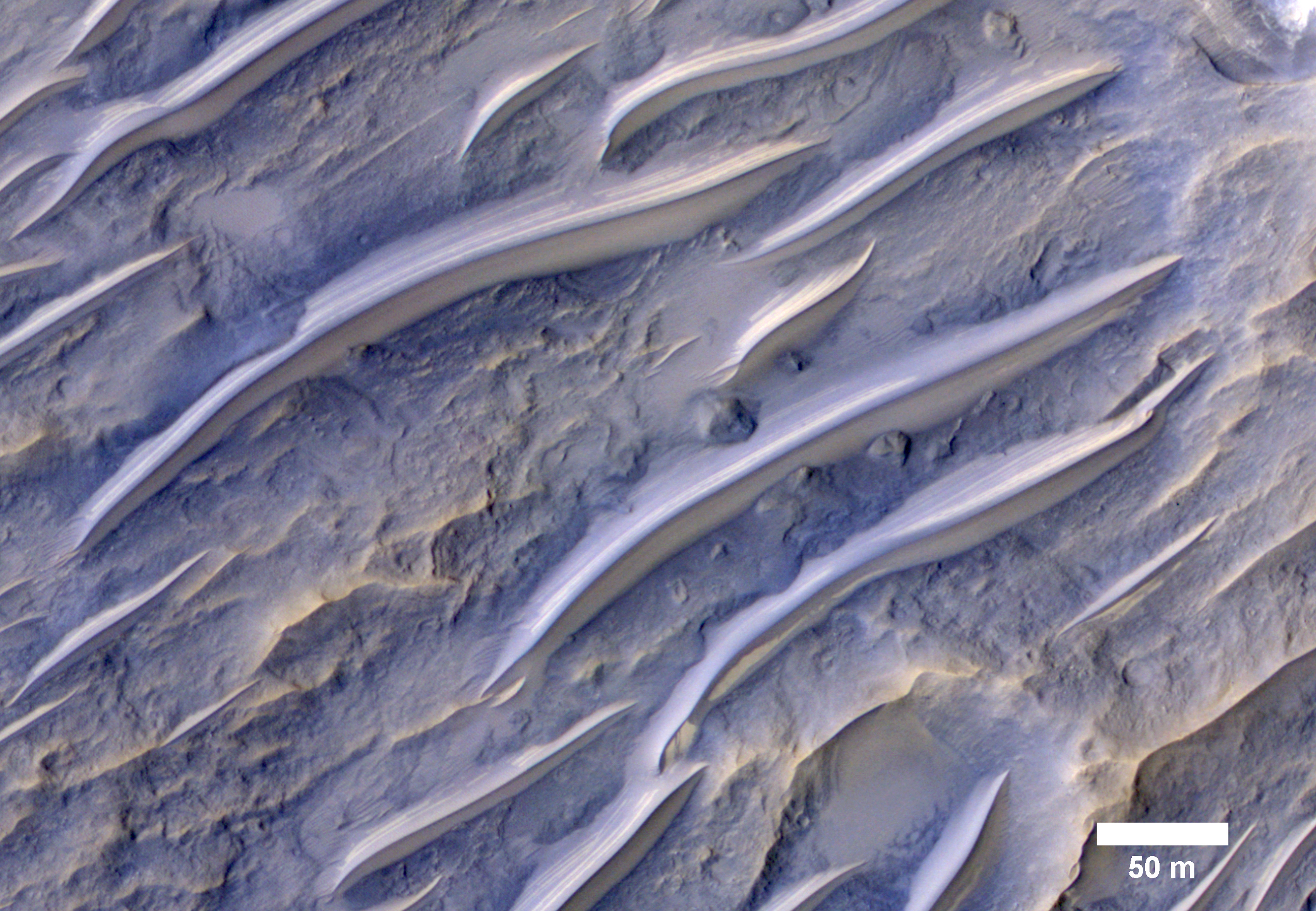
The tropics of Mars are commonly littered with small bright ripples that were somehow shaped by the wind. Called "transverse aeolian ridges", or TARs, the features stand up to 6 meters tall and are spaced a few tens of meters apart. They are typically oriented transverse to modern day wind directions, and often found in channels and crater interiors. The physical process that produces these features is still mysterious. Most TARs display no evidence of internal structure, so it is difficult to discern exactly how they were formed.

While validating a HiRISE digital terrain model of the area, Sarah Mattson of the University of Arizona discovered these rare banded TARs in Iapygia, south of Syrtis Major. These features resemble TARs elsewhere on Mars, except that they show bands or layers on their northwest faces but fewer or none on the southeast sides.

One possible interpretation of this strange layering is that these particular TARs are made up of wedge-shaped layers, as shown in the schematic cross-section illustrating the inferred structure of the TARs. If this hypothesis is correct, it implies that the ripples grew vertically over time, as material accreted at the crests of the ridges. It also suggests that the banded slopes faced upwind.

This observation might provide a valuable clue to the formation of TARs elsewhere on Mars, if they have a similar internal structure but that structure cannot be seen because they are made up of homogeneous materials that are uniform in color.

This is a stereo pair with ESP_021639_1610.

Image credit: NASA/JPL/University of Arizona

Note: For more information, see PIA18806: Banded TARs in Iapygia.

Tuesday, September 16, 2014

Northern Slope of Melas Chasma


Today's VIS image shows part of Melas Chasma.

Orbit Number: 56149 Latitude: -10.2791 Longitude: 290.34 Instrument: VIS Captured: 2014-08-11 01:30

Photo credit: NASA/JPL-Caltech/Arizona State University

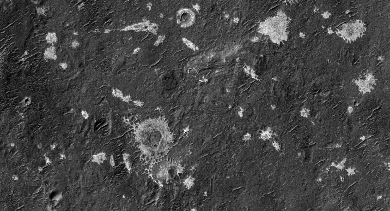
Light-Toned Deposits in Vinogradov Crater


Vinogradov is an old, 224-kilometer diameter, heavily degraded impact crater in southern Margaritifer Terra.

The southeastern floor of Vinogradov is covered with several mysterious light-toned, sub-meter scale “blobs” that lack obvious layering. In some places the light-toned material appears to have filled pre-existing craters giving them a circular appearance.

The light-toned material has a northwest-southeast orientation and tends to be associated with a smooth, darker-toned deposit. This material may be related to ejecta from a nearby crater, eroded from the rim of Vinogradov or emplaced by some other process.

This is a stereo pair with ESP_037519_1590.

Image credit: NASA/JPL/University of Arizona

Note: For more information, see PIA18805: Mysterious Light-Toned Deposit in Vinogradov Crater.

Monday, September 15, 2014

Chaotic Terrain in Eridania Basin


Eridania is the name of topographically enclosed basin located in the southern highlands of Mars that has been suggested to be the site of a large ancient lake or inland sea.

A chaotic jumble of relatively bright blocks sits on the lowest floor regions of the basin, sampled in this image. These blocks contain a variety of hydrated minerals that could have formed in the water, perhaps preserving information about an ancient habitable environment.

This lake or sea partially drained to form the Ma'adim Vallis, a large channel that itself drained into Gusev Crater to the north. The Spirit rover landed in Gusev Crater in 2004 to study the expected lake deposits, but found that the floor of the crater had been covered by lava that was younger than the fluvial activity.

Eridania is a better place to find lake sediments, but is too rough and dangerous for the landing systems sent to Mars in the past.

Image credit: NASA/JPL/University of Arizona

Note: For more information, see PIA18804: Chaos in Eridania Basin.

Sunday, September 14, 2014

Murray Buttes Mesa


This image, taken with the High Resolution Imaging Science Experiment (HiRISE) camera, shows a mesa within the "Murray Buttes" area on Mars showing a complex fracture pattern (black arrow) protruding from the eroding rock. This mesa, which likely represents a remnant of crater floor sediments, lies on top of the sedimentary rocks of the Murray Formation. NASA's Curiosity rover will be exploring this formation.

Image credit: NASA/JPL-Caltech/University of Arizona

Note: For more information, see PIA18784: Bands on the 'Murray Formation' and PIA18785: Geological Transition.

Saturday, September 13, 2014

Daedalia Planum Lava Flows


The region of this VIS image shows several different flow surfaces, including platy and lobate. These flows are part of Daedalia Planum.

Orbit Number: 56139 Latitude: -20.1869 Longitude: 220.191 Instrument: VIS Captured: 2014-08-10 05:41

Photo credit: NASA/JPL-Caltech/Arizona State University

Strata Thickening in Amargosa Valley


This portion of a color mosaic taken by NASA's Mars Curiosity rover shows strata exposed along the margins of the valleys in the "Pahrump Hills" region on Mars. The scale of layering increases upward, providing what's called a "thickening upward" trend. This is consistent with a variety of ancient environments, in particular those that involved water.

This image was taken by the rover's Mast Camera (Mastcam). It has been white-balanced to show how the scene would appear under Earth's lighting conditions.

Image credit: NASA/JPL-Caltech/MSSS

Friday, September 12, 2014

Western Flank of Pavonis Mons


Today's VIS image shows part of the western flank of Pavonis Mons.

Orbit Number: 56138 Latitude: 1.02298 Longitude: 246.073 Instrument: VIS Captured: 2014-08-10 03:49

Photo credit: NASA/JPL-Caltech/Arizona State University

Amargosa Valley


This image from NASA's Mars Curiosity rover shows the "Amargosa Valley," on the slopes leading up to Mount Sharp on Mars. The rover is headed toward the "Pahrump Hills" outcrop, seen above the scale bar. This area represents a boundary between the plains of Gale Crater, named Aeolis Palus, and the layered slopes of Mount Sharp, or Aeolis Mons. Curiosity has recently crossed into this terrain and now is on the Mount Sharp side of the transition zone.

This image was taken by the rover's Mast Camera (Mastcam). It has been white-balanced to show how the scene would appear under Earth's lighting conditions.

Image credit: NASA/JPL-Caltech/MSSS

Note: For more information, see
* PIA18474: Slopes of Mount Sharp
* PIA18475: Curiosity's Next Steps
* PIA18780: Curiosity Rover Planned Route
* PIA18781: Map of Lower Mount Sharp
* PIA18782: Geologic Cross-Section
* NASA's Mars Curiosity Rover Arrives at Martian Mountain

Thursday, September 11, 2014

Aeolis Mensae


This VIS image shows a small portion of Aeolis Mensae, a complex region of hills, plateaus and graben. The prominent channel in the lower half of the image is a fault bounded graben.

Orbit Number: 56129 Latitude: -6.33435 Longitude: 146.63 Instrument: VIS Captured: 2014-08-09 10:00

Photo credit: NASA/JPL-Caltech/Arizona State University

Wednesday, September 10, 2014

Avernus Colles


The hills in this VIS image are part of Avernus Colles.

Orbit Number: 56128 Latitude: -1.54092 Longitude: 174.827 Instrument: VIS Captured: 2014-08-09 08:03

Photo credit: NASA/JPL-Caltech/Arizona State University

Opportunity's Tracks Along the Western Rim of Endeavour Crater


This scene from the panoramic camera (Pancam) on NASA's Mars Exploration Rover Opportunity looks back toward part of the west rim of Endeavour Crater that the rover drove along, heading southward, during the summer of 2014.

The vista merges multiple Pancam exposures taken on August 15, 2014, during the 3,754th Martian day, or sol, of Opportunity's work on Mars.

The high point on the rim in the left half of the scene is the southern end of "Murray Ridge." Tracks from drives from mid-July 2014 are faintly visible near there, and tracks from subsequent drives advance to the foreground. For scale, the distance between Opportunity's parallel wheel tracks is about 3.3 feet (1 meter).

The most distant visible tracks are from nearly half a mile (more than 700 meters) prior to Opportunity's arrival at the viewpoint from which this scene was recorded.

This version of the image is presented in approximate true color by combing exposures taken through three of the Pancam's color filters, centered on wavelengths of 753 nanometers (near-infrared), 535 nanometers (green) and 432 nanometers (violet).

A false-color version, at http://photojournal.jpl.nasa.gov/catalog/PIA18605, makes the tracks more visible. A video at http://www.jpl.nasa.gov/video/?id=1325 places the scene into context of the rover's entire route of more than 25 miles (40 kilometers) since its 2004 landing. A map indicating the rover's Sol 3754 location (as the location reached by a Sol 3752 drive) is online at http://mars.nasa.gov/mer/mission/tm-opportunity/opportunity-sol3757.html.

Image credit: NASA/JPL-Caltech/Cornell University/Arizona State University

Note: For more information, see PIA18605: Rover Tracks in Northward View Along West Rim of Endeavour, False Color, PIA18606: Rover's Tracks in Stereo View Along Rim of Endeavour Crater, and Mars Rover Opportunity's Vista Includes Long Tracks.

Tuesday, September 9, 2014

Ma'adim Vallis


This VIS image shows a portion of Ma'adim Vallis, which is a large channel that enters Gusev Crater from the south. Gusev Crater is the "home" of the MER rover named Spirit.

Orbit Number: 56128 Latitude: -18.5885 Longitude: 177.177 Instrument: VIS Captured: 2014-08-09 07:57

Photo credit: NASA/JPL-Caltech/Arizona State University

Saturday, September 6, 2014

Lava Flows on the Southeastern Flank of Olympus Mons


The lava flows in this VIS image are located on the eastern flank of Olympus Mons.

Orbit Number: 56126 Latitude: 16.5299 Longitude: 230.021 Instrument: VIS Captured: 2014-08-09 04:12

Photo credit: NASA/JPL-Caltech/Arizona State University