Saturday, August 31, 2013

Mangala Valles


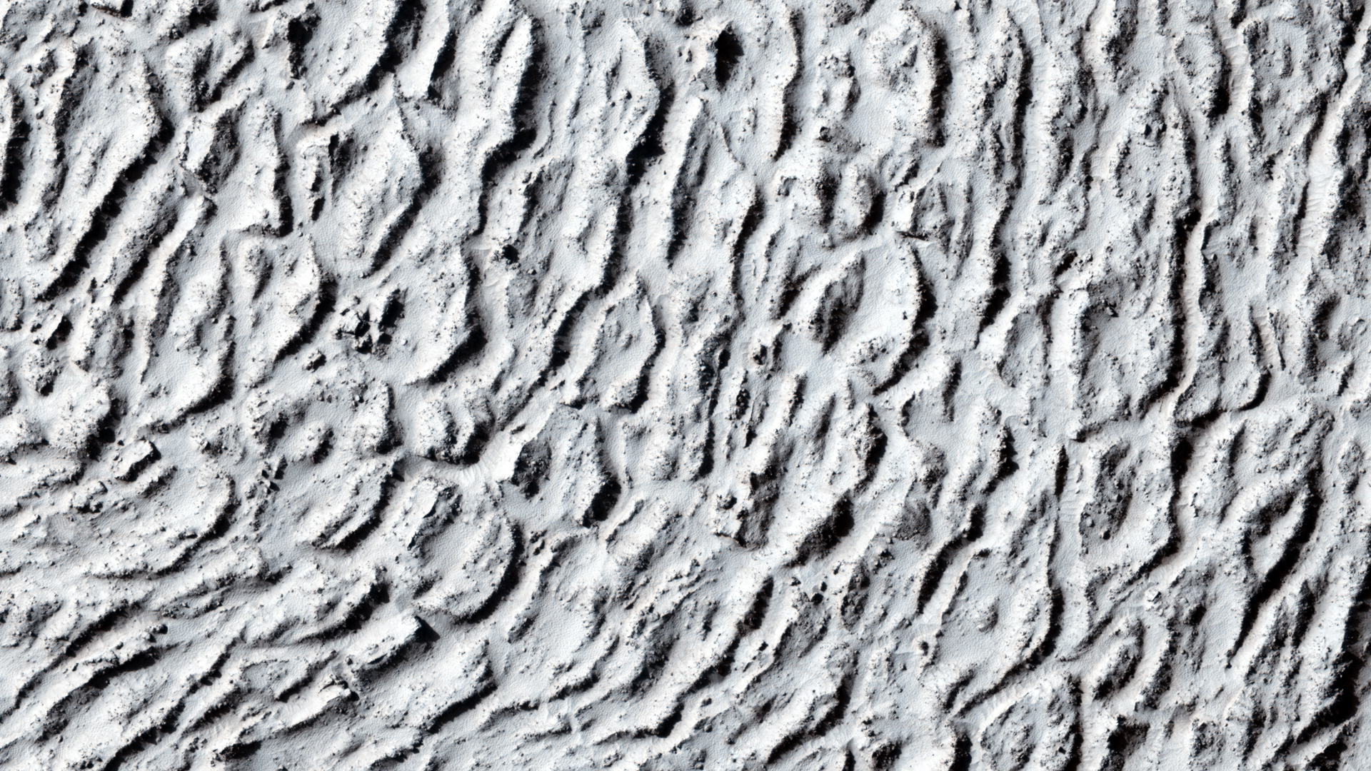
Today's VIS image was collected at the same time as yesterday's IR image. Streamlined islands are located in the channel of Mangala Valles, a portion of which is shown in the image.

Orbit Number: 51226 Latitude: -14.5365 Longitude: 209.862 Instrument: VIS Captured: 2013-07-01 21:39

Photo credit: NASA/JPL-Caltech/Arizona State University

Hadriacus Mons and Dao Vallis


This daytime IR image shows part of the patera (summit depression) and eroded flank of Hadriacus Mons at the top of the image and a section of Dao Vallis at the bottom of the image.

Orbit Number: 51230 Latitude: -33.0654 Longitude: 91.7634 Instrument: IR Captured: 2013-07-02 05:38

Image credit: NASA/JPL-Caltech/Arizona State University

Artik Crater

From the USGS Astrogeology Science Center:

The IAU Working Group for Planetary System Nomenclature has approved the name Artik for a crater on Mars. For more information, see the map of MC-29 in the Gazetteer of Planetary Nomenclature.

Lava Flow in an Impact Crater in Tartarus Montes


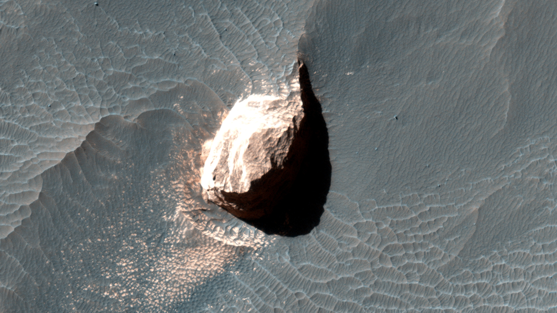
In this image, we can see a small notch in a crater rim with a well-formed channel. Lava appears to have flowed through this notch and filled in this approximately 10-kilometer (6-mile) diameter crater.

Obtaining another image of the same area at a different angle (what we then call a "stereo pair") can help us see this terrain in three dimensions and answer some questions about what happened here, e.g., is the high-lava mark consistent with the lava overtopping the exterior? Did the crater fill to the level of the lava outside?

This is a stereo pair with ESP_028637_2040.

Photo credit: NASA/JPL/University of Arizona

Friday, August 30, 2013

Curiosity's Route Map from Landing to Mount Sharp


NASA's Mars rover Curiosity left the "Glenelg" area on July 4, 2013, on a "rapid transit route" to the entry point for the mission's next major destination, the lower layers of Mount Sharp. As of Aug. 27, 2013, NASA's Mars rover Curiosity has driven about 0.86 mile (1.39 kilometers) since leaving Glenelg, with about 4.46 miles (7.18 kilometers) remaining to get to the entry point. The rover's drive on August 27, the 376th sol (Martian day) of the mission, was the first Curiosity drive using the rover's autonomous navigation capability to safely drive beyond the area that rover drivers on Earth could evaluate from images before the drive. The rover can analyze stereo images that it takes during the drive and choose the best path to continue driving.

The rapid transit route was plotted on the basis of images from the High Resolution Imaging Science Experiment (HiRISE) camera on NASA's Mars Reconnaissance Orbiter. Actual drives are based on images from Curiosity's own cameras, and the total driving distance to the entry point could differ from the length of the rapid transit route.

Curiosity's science team has identified some geological waypoints along the rapid transit route where driving may be suspended for a few sols to allow time for studying local features. The rover has about 0.31 mile (500 meters) left to go before reaching the first of these waypoints. For a broader-context image of the area, see http://photojournal.jpl.nasa.gov/catalog/PIA16058.

This map shows Curiosity's location at the end of the Sol 376 drive, in the context of the mission's initial drive from the landing site at Bradbury Landing to Glenelg and the route of the current drive from Glenelg to the Mount Sharp entry point. Geological waypoints along the route are also indicated. The base map is from the orbiting HiRISE camera. North is toward the top. The dark ground south of the rapid transit route has dunes of dark, wind-blown material. The 4-kilometer scale bar on the map is about 2.5 miles long.

Image credit: NASA/JPL-Caltech

Oxbows and Cutoffs in Idaeus Fossae


As rivers age they can meander and occasionally these meanders get so pronounced that the river cuts off these curving loops at their narrow end leaving them as isolated as oxbow lakes.

The objective of this observation is to check for the presence of these features. At HiRISE resolution, we should be able to test for traces of former meandering river channels in what looks like an oxbow feature in images from lower-resolution cameras.

Photo credit: NASA/JPL/University of Arizona

Thursday, August 29, 2013

Mangala Valles


This IR image shows streamlined islands in the channel of Mangala Valles.

Orbit Number: 51226 Latitude: -15.5089 Longitude: 209.731 Instrument: VIS Captured: 2013-07-01 21:39

Image credit: NASA/JPL-Caltech/Arizona State University

Annular Eclipse of the Sun by Phobos


This set of three images shows views three seconds apart as the larger of Mars' two moons, Phobos, passed directly in front of the sun as seen by NASA's Mars rover Curiosity. Curiosity photographed this annular, or ring, eclipse with the telephoto-lens camera of the rover's Mast Camera pair (right Mastcam) on August 20, 2013, the 369th Martian day, or sol, of Curiosity's work on Mars.

Curiosity paused during its drive that sol for a set of observations that the camera team carefully calculated to record this celestial event. The rover's observations of Phobos help researchers to make measurements of the moon's orbit even more precise. Because this eclipse occurred near mid-day at Curiosity's location on Mars, Phobos was nearly overhead, closer to the rover than it would have been earlier in the morning or later in the afternoon. This timing made Phobos' silhouette larger against the sun -- as close to a total eclipse of the sun as is possible from Mars.

Image credit: NASA/JPL-Caltech/Malin Space Science Systems/Texas A&M University

Note: For more information, see NASA Mars Rover Views Eclipse of the Sun by Phobos.

Wednesday, August 28, 2013

Hebes Chasma


This VIS image shows part of the wall of Hebes Chasma as well as the complex floor materials.

Orbit Number: 51210 Latitude: -0.400442 Longitude: 284.162 Instrument: VIS Captured: 2013-06-30 15:57

Photo credit: NASA/JPL-Caltech/Arizona State University

Discovery Ridge and Sand Ripples


This mosaic of images from the Navigation Camera (Navcam) on NASA's Mars rover Curiosity shows the scene from the rover's position on the 376th Martian day, or sol, of the mission (August 27, 2013). The images were taken right after Curiosity completed the first drive during which it used autonomous navigation on unknown ground.

The view is centered toward the southwest and spans from east, at left, to north, at right. The prominent rock pile in the middle distance, left of center, is called "Discovery Ridge." The largest rocks in that pile are about 1 foot (0.3 meter) across. About 26 feet (8 meters) to the right of Discovery Ridge is a ripple of wind-deposited material. The ripple is about 13 feet (4 meters) long and begins about 33 feet (10 meters) from the rover.

The mosaic is presented as a cylindrical projection.

Image credit: NASA/JPL-Caltech

Note: For more information, see NASA'S Mars Curiosity Debuts Autonomous Navigation.

Tuesday, August 27, 2013

Arsia Mons


This VIS image shows part of the summit caldera on Arsia Mons.

Orbit Number: 51200 Latitude: -10.169 Longitude: 239.951 Instrument: VIS Captured: 2013-06-29 18:17

Photo credit: NASA/JPL-Caltech/Arizona State University

Monday, August 26, 2013

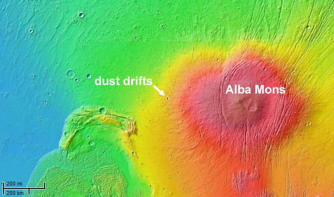
"Whiskers" West of Alba Mons


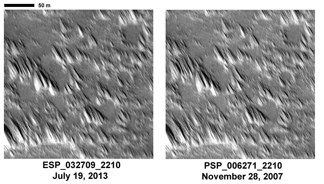
This image was intended to search for surface changes after three Mars years in a dust-covered region west of the Alba Mons volcano. It was acquired at almost the exact same season as another image in 2007, and the illumination and viewing angles are very similar.

The earlier image showed thick dust deposits accumulated downwind of topographic obstacles, apparently formed by winds blowing across the surface. These deposits, nicknamed “whiskers,” are evidently rare on Mars, so far found in only a few places such as the summit of Tharsis and on the flanks of the giant volcanoes. Their ages and origins are still poorly known. We expected that wind-related changes could be taking place here in particular because of the location's low elevation in comparison to similar dust deposits elsewhere on Mars. The atmosphere is denser at this elevation, near Martian “sea-level,” than at the tops of the giant volcanoes, so the winds are more effective at eroding and transporting sediment.

A comparison of the new image with the image taken in 2007 shows no discernible differences in the dust deposits. Analysis of the full image is still ongoing, but it is already clear that no major surface changes took place in this location over the three Mars year interval between the two pictures. This is instructive because it tells us that the dust deposits are resistant to wind erosion (under normal winds at least; the last major global dust storm was in early 2007, before PSP_006271_2210 was taken) and that no new dust deposition has taken place.

This result suggests that either these deposits form and evolve very slowly, over time scales much longer than three years, or else they formed during a past period when the winds were much stronger than they are today.

Photo credit: NASA/JPL/University of Arizona

Sunday, August 25, 2013

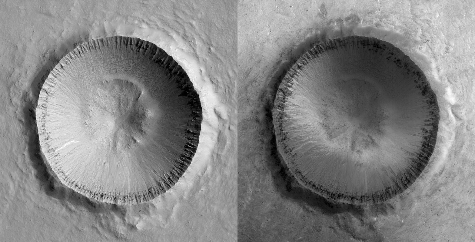
Frosted Impact Crater in Scandia Colles


This image was planned to search for gully activity in the Northern Hemisphere. Changing gullies have so far been documented only in the Southern Hemisphere, where a greater thickness of carbon dioxide frost forms in the winter.

The gullies are active when this frost is present, especially in the late winter and spring as it sublimates. The well-preserved crater here has a bright gully deposit (visible in prior images acquired in late northern summer), which suggests recent activity. An animated GIF blinking between these two images (at reduced resolution) shows how it changes in appearance with the seasons.

Photo credit: NASA/JPL/University of Arizona

Note: This crater is located in the Scandia Colles region of Vastitas Boreales.

Saturday, August 24, 2013

Samara Valles


Today's VIS image shows a portion of Samara Valles.

Orbit Number: 51159 Latitude: -22.3929 Longitude: 340.178 Instrument: VIS Captured: 2013-06-26 09:23

Photo credit: NASA/JPL-Caltech/Arizona State University

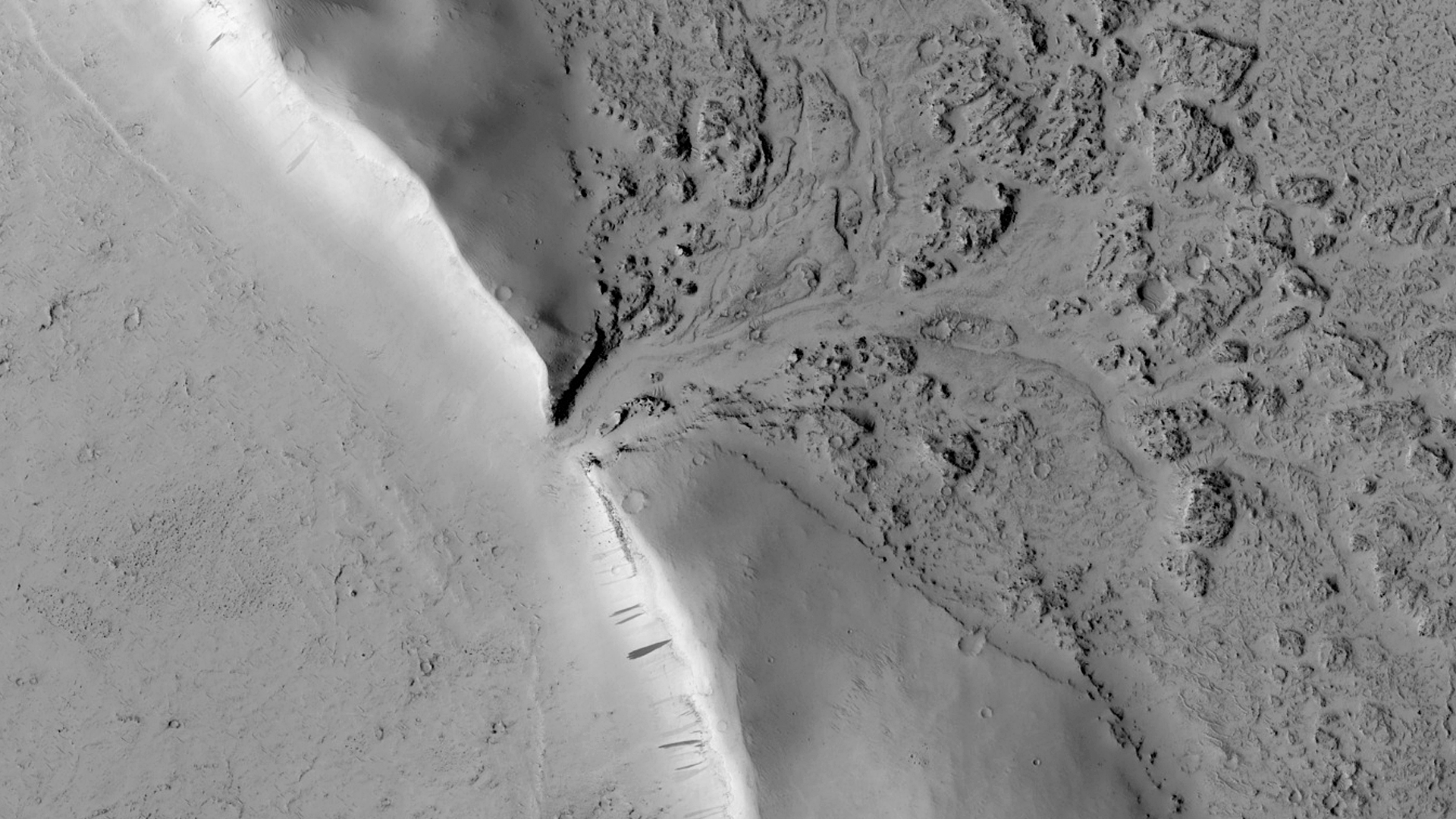
Lava Against an Impact Crater in Elysium Planitia


This image shows lava crumpled against the upstream side of an impact crater. In places where we see smaller ridges in the lava, they have steep faces that retain less dust and look rocky. Because of the lesser amount of dust, we might be able to see better details of the topography.

The crater itself is extremely old, having long been filled in with dust and its rim severely eroded. Note also the flat surrounding terrain.

This is a stereo pair with ESP_019170_1860.

Photo credit: NASA/JPL/University of Arizona

Friday, August 23, 2013

Asimov Crater


This VIS image shows some of the depressions in the material that fills Asimov Crater.

Orbit Number: 51158 Latitude: -47.1293 Longitude: 4.95194 Instrument: VIS Captured: 2013-06-26 07:03

Photo credit: NASA/JPL-Caltech/Arizona State University

Light-Toned Material in Pollack Crater


This observation shows a small crater in within the much larger Pollack Crater containing light-toned material. Pollack Crater is a 90-kilometer diameter impact crater first imaged by the Mariner 9 spacecraft.

This material was first observed by the THEMIS team, and there are multiple Context Camera and Mars Orbiter Camera images showing that this light-toned material may be similar to the large “White Rock” outcrop to the northwest. HiRISE has also imaged White Rock several times. In these cases, we can see how different teams can work together to get an interesting image at high resolution for further study.

Photo credit: NASA/JPL/University of Arizona

Thursday, August 22, 2013

Rabe Crater Dunes in Visible Light


Today's VIS image was collected at the same time as yesterday's IR image. In the visible wavelengths, the dunes are darker than their surroundings. Compare to yesterday's IR image, where the dunes are bright because of their warmer temperature.

Orbit Number: 51157 Latitude: -43.6777 Longitude: 34.3986 Instrument: VIS Captured: 2013-06-26 05:33

Photo credit: NASA/JPL/Arizona State University

Wednesday, August 21, 2013

Rabe Crater Dunes in Infrared


This daytime IR image shows part of the dune field on the floor of Rabe Crater. The dunes show up as brighter than the surrounding materials because they are warmer.

Orbit Number: 51157 Latitude: -43.6589 Longitude: 34.4001 Instrument: IR: Captured: 2013-06-26 05:32

Photo credit: NASA/JPL/Arizona State University

Tuesday, August 20, 2013

Valley Networks in Aonia Terra


The numerous valleys in this VIS image are dissecting part of Aonia Terra.

Orbit Number: 51073 Latitude: -48.9491 Longitude: 294.943 Instrument: VIS Captured: 2013-06-19 07:41

Photo credit: NASA/JPL/Arizona State University